
The Mosgiel-Taieri Safer School Streets Project aims to alleviate safety issues and barriers to active transport that students and parents experience when travelling to and from schools and recreational activities. Project partners are four schools (Elmgrove School, Silverstream Primary, Taieri College and Outram School), the Mosgiel-Taieri Community Board and DCC Transport.
Safety improvements such as pedestrian crossings and refuge islands are planned to be installed in surrounding streets for three schools in Mosgiel-Taieri, making it safer for families to pick up or drop off their children farther from the school. This will reduce congestion and improve road safety for everyone in the area.
The design for these safety enhancements has been developed based on feedback received from the previous live trials held in October, 2020.
These safety improvements will support the recently approved 30km/h speed limit change for school zones as outlined in the Interim Speed Management Plan 2023/24, which are currently being implemented.
Elmgrove School
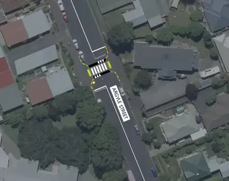
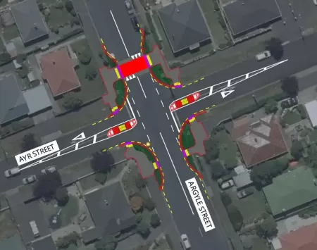
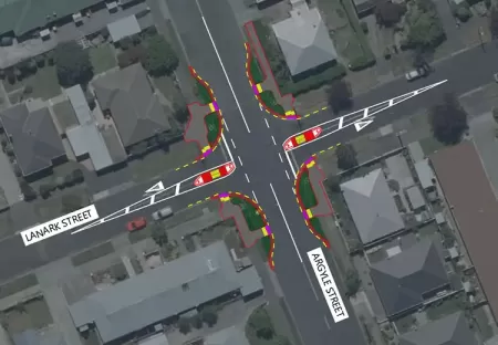
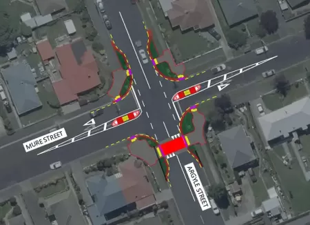
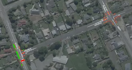
The installation of safety improvements around Elmgrove School in Mosgiel has ensured four intersections on Argyle St will have improved crossing points.
The planned timeline for this work is for completion by the end of June 2024.
The map shows the extent of the confirmed works, which include:
- Argyle & Lanark St – Kerb buildout with a refuge island, crossing points, and road markings.
- Argyle & Ayr St - Kerb buildout with a refuge island, raised courtesy crossing, crossing points, and road markings.
- Argyle St – The existing crossing will be upgraded to a raised pedestrian (zebra) crossing.
- Argyle & Mure St - Kerb buildout with a refuge island, raised courtesy crossing, crossing points and road markings.
Changes maps
Elmgrove School maps - click on the images to view full screen
Outram School
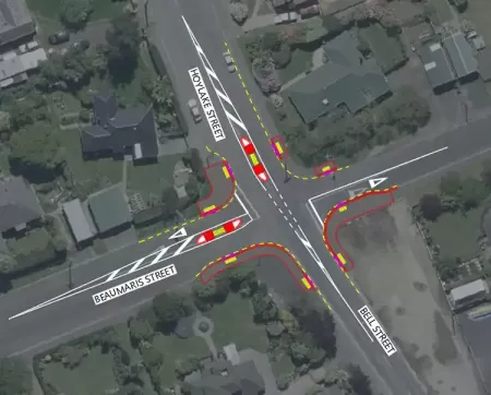
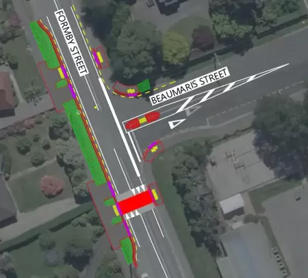
DCC contractors are installing safety enhancements at Formby/Beaumaris St and the Bell/Hoylake/Beaumaris St intersection.
These changes will facilitate safer crossings for pedestrians at the Formby/Beaumaris St and Bell/Hoylake/Beaumaris St intersections. The planned timeline for this work is for completion before end of June 2024.
The extent of the confirmed works include:
- Formby & Beaumaris St – Kerb buildouts, crossing points, pedestrian refuge island, raised courtesy crossing and road markings.
- Bell, Hoylake & Beaumaris St – Kerb buildouts, crossing points, pedestrian refuge island and road markings.
Changes maps
Outram School maps - click on the images to view full screen
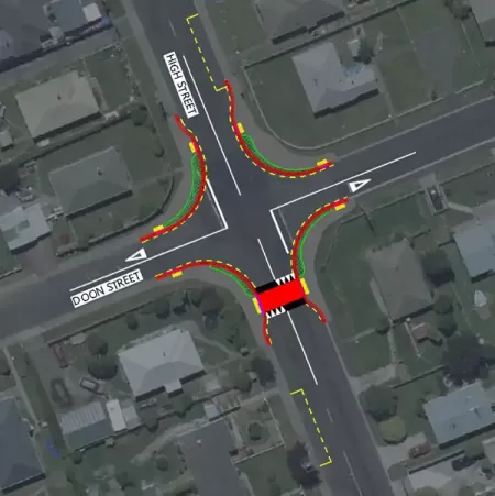
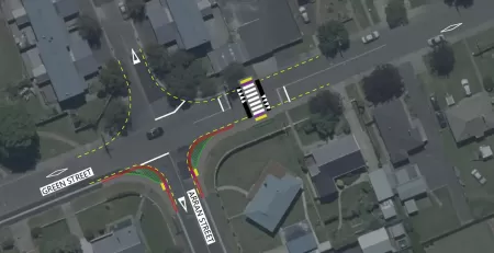
Taieri/Silverstream
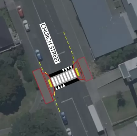
Safety enhancements are installed on Church St, Green/Arran St and High/Doon St intersections.
These changes will facilitate safer crossings for pedestrians at the Church St, Green/Arran St and High/Doon St intersections. This will make it safer for families to pick up or drop off their children farther from both Silverstream School and Taieri College.
The planned timeline for this work is for completion before end of June 2024.
The extent of the confirmed works include:
- Church St – Existing pedestrian crossing will be raised.
- Green/Arran St – Kerb buildouts, crossing points, raised pedestrian crossing and road markings.
- High/Doon St – Kerb buildouts, crossing points, raised courtesy crossing, bus stop relocation and road markings.
Changes maps
Silverstream School and Taieri College maps
Silverstream School and Taieri College maps - click on the images to view full screen
Mosgiel-Taieri Safer Schools trial information and feedback 2021
-
Safer School Streets trials June 2021
End of trial – June 2021
The Mosgiel-Taieri Safer School Streets trial has been completed. Outcomes of the trial include support for introducing speed zones and lower speed limits around schools and the installation of pedestrian crossings and walking, cycling and scootering infrastructure. There were mixed views about new intersection layouts with concerns about vehicles and bicycles being unable to safely navigate the layouts.
As part of our road safety improvements programme around Dunedin schools, we will be consulting on permanent infrastructure next. The proposed improvements include raised crossings outside schools and reducing speed limits using electronic speed zone signs and kerb buildouts at intersections. This work is likely to be carried out in 2021 - 2022 near Outram and Silverstream Schools and in 2022 - 2023 around Elmgrove School, subject to funding.
We have removed bollards outside Elmgrove School.
See engagement report below
Adjusting Mosgiel-Taieri Safer School Streets trials
In response to community feedback, the Dunedin City Council is adjusting its trial road safety work in Mosgiel and Outram streets.
The Mosgiel-Taieri Safer School Streets project aims to provide a safer environment for children getting to and from school and to encourage parents to let their children bike, scooter and walk to school. The project was initiated following a request by the Mosgiel-Taieri Community Board in 2018.
There have been serious crashes on some of the roads the DCC wants to improve. More importantly, it wants to prevent future crashes. A major factor for road safety is vehicle speeds which are currently too high on popular routes to school.
The DCC received feedback from 280 people following its recent trial and has listened. The majority of people didn’t like the planter boxes so they will be removed.
It received feedback from the community about the removal of a bus stop outside the Mosgiel Medical Centre and that will be reinstated.
The DCC also received a lot of feedback about where crossings and associated kerb builds outs were located, which it has taken on board and will change. Crossings reduce the lane width to reduce the crossing distance for pedestrians and help slow vehicle speeds.
Changes to be made to the crossing points in Mosgiel are a direct result of feedback from the community.
As part of the DCC’s ongoing safety work, it also wants to talk to the community about the introduction of a cycle lane and, as part of DCC’s Art in Infrastructure Policy, introducing street art. The community will be asked about painting art on the road inside the new kerb build outs outside Silverstream and Elmgrove Schools (see image below).
The DCC will survey the community about whether they would like a cycle lane on High Street, between Factory Road and Green Street. This would connect the Factory Road cycle lane and service the area near Silverstream School and Taieri College. The road is wide here and there would be no loss to parking as a result of a cycle lane.
The DCC will send letters to Berwick and Montrose Street residents and ask the community if they support a month-long trial closure of these streets to through traffic. These streets were chosen because children walk along them to school and the closure would reduce traffic volumes, making them safer for walking, cycling, and scooting. It would also reduce the number of side roads that pedestrians and cyclists need to cross on Bush Road. A decision on whether to go ahead with this will depend on the outcome of residents’ and community feedback and will not go ahead unless supported by the majority of residents and community surveyed.
The DCC Transport team will also be available to talk about the project at the Mosgiel Library on 1 – 4 March .
This trial work is a new approach to project delivery and community engagement and is in line with Waka Kotahi NZ Transport Agency’s Innovating Streets for People Programme, which is funding 90% of this project and is consistent with Waka Kotahi’s guidelines on street design.
To date, installation of the trials in Mosgiel and Outram has cost $31,000 and DCC’s contribution is $3,100.

Information for the trials
-
FAQS
What is the purpose of the project trials?
Through a survey of Mosgiel and Outram schools, many parents told us they don’t feel it’s safe for their children to walk or scoot to school. This is mainly because of the lack of crossings, driver behavior and vehicle speeds on routes to schools. The project aims to improve roads and pedestrian infrastructure for children and their caregivers, so they feel safer walking and scooting to and from school. We’re seeking to achieve this mainly through more crossings and crossings with shorter crossing distances and intersection layouts which aim to slow down vehicles.
Who asked for this project?
The Mosgiel-Taieri Community Board asked us in 2018 to develop this project.
How do the trials work?
The trials are a new approach of consulting as people’s opinions on the work helps us get it right. They allow residents to see what their streets would look like and enable more informed, real-time feedback, rather than from paper plans. Trials enable infrastructure to be tested, feedback and other data to be collected and changes to be made until a design has evolved that’s fit for permanent implementation
What changes have been made to the infrastructure installed in 2020?
Crossings have been moved and removed, a new crossing installed and the planter boxes removed.
Why have these changes been made?
Because of feedback we received from 280 people during consultation in 2020 and from site observations and other information sources.
What changes are being planned or proposed for the near future?
In a few weeks’ time, some crossings immediately outside schools will be painted red and artwork will be painted inside kerb buildouts. The purpose of this is to encourage slower speeds and awareness of crossings and walking activities. We will hold a community workshop before the kerb build outs are painted to co-design the artwork.
We are currently surveying affected residents about whether they would like a cycle lane on High Street, between Factory Road and Green Street. This would connect the Factory Road cycle lane and service the area near Silverstream School and Taieri College. The road is wide here and there would be no loss to parking as a result of a cycle lane.
We are proposing a month-long trial closure of Berwick and Montrose Streets at the Bush Road end create quieter streets that are safer for walking, cycling and scooting. A decision on whether to go ahead with this will depend on the outcome of residents’ opinions and will not go ahead unless supported by the majority of residents surveyed.
What do we want to achieve by closing off Montrose and Berwick St at Bush Road?
- To reduce the number of side roads that pedestrians and cyclists need to cross when travelling on Bush Road.
- To reduce vehicle volumes on those side streets, making them safer for people walking, cycling and scooting.
- There are four access points from Bush Road into the area around Elmgrove School. It is not necessary to have that many access points. Two of the access points/streets can be made quiet and therefore being more suitable for pedestrians and cyclists while the other two access points can still be used by cars.
Why did you choose those two streets?
- Because the residential area being serviced by Berwick and Montrose Streets and Bush Road is small and contained, so it won’t affect too many people and traffic volumes being directed to the Bush Road - Argyle Street intersection are low. We anticipate the Bush Road - Argyle St intersection will be able to cope with extra traffic.
- Because Berwick Street and Montrose Street are on the route to school for many children travelling from the residential area on the other side of Bush Rd.
Will the changes you have made on the streets stay this way?
This will depend on the feedback we receive and observations we make, so it’s too early to say. Once the trials process has evolved into a design that is fit for permanent implementation, we aim to make them permanent in the next three-year funding cycle.
When does the trial end?
It ends when permanent infrastructure is put in place.
Waka Kotahi funding ends in June 2021, so we expect that the trial phase of this project will end then.
What is the cost of the trial?
The implementation of stage 1 trials have cost $31,000, of which DCC’s share is $3,100. The remainder is being paid by Waka Kotahi NZ Transport Agency. The changes that are currently being made to the trials are expected to cost less.
What are the next steps?
We’ll analyse the feedback we receive and discuss it with the working group, made up of community board and school representatives. We’ll also consider speed counts, site observations and other information sources. We will use the feedback to help refine the design of this work and define next steps. We’ll let the community know about changes, findings and next steps through school newsletters, social media and online.
-
Statistics
Mosgiel-Taieri Safer School Streets statistics
More people are dying or are seriously injured on Dunedin roads.
Speed is a major factor.
63% of deaths and serious injuries happen on 50km city roads.
More than half involved children, the elderly, walkers, cyclists and motorcyclists.
Vehicle speeds
Data collected by the DCC in Mosgiel and Outram in 2018 – 2020 showed:
- Argyle St – 85% of vehicles travelled at or below 55km/h before the 2020 trails. During the trials, 85% of vehicles travelled at or below 52km/h. That is a 5.5% reduction.
- Bush Rd – 85% of vehicles travelled at or below 54km/h before the trails. During the trials, 85% of vehicles travelled at or below 53km/h. That is a 2% reduction.
- Green St – 85% of vehicles travelled at or below 48km/h during the trial.
Crashes
Stats from the last 10 years show three accidents were reported involving pedestrians within the trial area. Two people had minor injuries and one a serious injury.
Mosgiel-Taieri school rolls in 2020
Total: 2317
- Taieri College – 1052
- Silverstream School – 285
- Elmgrove School – 328
- Outram School – 168
- St Mary’s School – 144
- Amana Christian School – 15
- East Taieri School – 325
Transport modes
Of students surveyed in 2018 (we received 142 responses):
- 11 biked
- 13 bused
- 95 were driven
- 6 scooted
- 17 walked
-
Timeline
Mosgiel-Taieri Safer School Streets timeline
Past
2017
Mosgiel Taieri Community Board’s Annual Plan proposes a network of accessways/cycleways project.
2018
- October – DCC partners with board to develop this project
- November –Schools, board and DCC form project team
- December – School parents surveyed.
2019
- January – Survey results show parents want more crossings and cycle lanes. They are concerned about driver behaviour and high vehicle speeds
- February 2019 – Project team develops concept.
2020
- June – Waka Kotahi NZ Transport Authority agrees to fund 90% of the project cost
- October– DCC installs trial crossings and kerb build outs
- October – November: Feedback collected and analysed.
2021
- December – January 2021: Project team planned changes to trials.
Feedback and results from the trials
-
Mosgiel-Taieri Safer School Streets feedback results
We received 280 submissions which gives us a better understanding of the community’s view on the project trials.
Feedback topics include crossings points (locations, dimensions and type and the impact on cycling). the need for cycle lanes, road and intersection width, speed calming and speed limits, loss of parking, impact on bus stops, look and use of planter boxes, education of parents and children and the engagement process.
We are currently analysing the feedback and the next step will be discussing it with the project working group, made up of community board and school representatives. We’ll also consider speed counts, site observations and other information sources. We'll use the feedback to help refine the design of this work and define the next steps of this project.
We’ll keep you updated about changes and findings through www.dunedin.govt.nz/Taieri-safer-streets, school newsletters and social media.
-
Answers to questions raised during feedback
What is the purpose of the project trials?
Through our 2019 survey of Mosgiel and Outram schools, many parents told us they don’t feel it’s safe for their children to walk or scoot to school. This is mainly because of the lack of crossings, driver behavior and vehicle speeds on routes to schools. The project aims to improve roads and pedestrian infrastructure for children and their caregivers, so they feel safer walking and scooting to and from school. We’re seeking to achieve this through more crossing points and crossings with shorter crossing distances and intersection layouts that aim to slow down vehicles.
Why weren’t we consulted before the trials were implemented?
The feedback we received in 2019 from students and parents from Mosgiel and Outram schools and input from the Mosgiel-Taieri Community board and schools helped us design the trial infrastructure.
The trials are our way of consulting as people’s opinions on the work helps us get it right. Local knowledge gives us a better understanding of the area, the community’s needs and improvements that can be made to the design.
Will the changes you have made on the streets stay this way?
No, these are just trials. The permanent work will look quite different. Also, they might be of a different nature or in different locations, depending on trial outcomes.
The trials allow residents to see what their streets would look like and enable more informed, real-time feedback, rather than from paper plans. Trials enable infrastructure to be tested, feedback and other data to be collected and changes to be made until we have achieved the best possible outcome.
I’m not happy with the look of the trials. Why do they look like this?
Trials are made up of low cost and easily movable materials such as bollards, line marking and removable planter boxes. They’re effective in testing and adjusting designs. Permanent infrastructure will look different. You can see examples of permanent infrastructure near central city schools in Dunedin here

Are ratepayers paying for the trials?
This project will receive 90% of its funding from Waka Kotahi NZ Transport Agency’s Innovating Streets for People Fund. The remaining 10% is funded by DCC, partly funded through residents’ rates.
Why aren’t you installing zebra crossings instead of crossing points?
Zebra crossings can’t be temporarily installed, adjusted and removed easily due to legal requirements for signage, markings and the need to be raised. Also, zebra crossings aren’t as safe as people might think, especially in areas with low pedestrian numbers. People in cars often don’t expect, look for or give way to pedestrians even though they have the right of way on zebra crossings.
Crossing points mark areas where it’s safe for pedestrians to cross if the road is clear. These crossings must have unobstructed visibility and short crossing distances.
Is it true the trials make it dangerous for people on bikes and in cars to share the road?
No, but in the absence of a dedicated cycle lane, people in cars and on bikes need to share the road safely. People in cars should give space to cyclists and cyclists should act predictably and carefully near cars.
Trial intersection layouts and crossing points reduce the lane width to reduce the crossing distance for pedestrians and slow vehicle speeds. People cycling in the parking lane now need to come into the vehicle lane as they cycle around these kerb buildouts, just like they need to when cycling around parked cars.
Intersections are too tight now and I can’t turn safely now. Can you fix this?
The width of the roads is still within the minimum best practice requirements and we ensured the intersections allow enough room for rubbish trucks to turn. We drove the routes before implementing the trials to make sure the layouts are safe and fit for purpose. Vehicles should slow down before turning to safely navigate the intersections. This will remove the need to cross the painted centreline.
How many crashes have there been on the roads involved in the trials?
There’ve been serious crashes on some of the roads we want to improve. More importantly, we want to prevent future crashes. A major factor for road safety is vehicle speeds. These are currently too high on routes to school, particularly on Bush Road, Argyle Street, Formby Street. Speed determines both the likelihood of a crash occurring and the severity of the outcome and vulnerable road users are particularly at risk. Lower speeds and better infrastructure such as crossing points with shorter crossing distances and better visibility increase safety.
We also want to make people feel safe enough to allow their children to walk and scoot to and from school. More children walking and cycling means less chaos at the school gates and increased road safety for everyone.
What are the next steps
We’ll analyse the feedback we’ve received and discuss it with the working group, made up of community board and school representatives. We’ll also consider speed counts, site observations and other information sources. We’ll use the feedback to help refine the design of this work and define next steps.
-
Mosgiel Safer school streets video
-
What the trial looked like.
What’s planned?
The Mosgiel-Taieri Safer School Streets project aims to provide a safer environment for all road users and encourage more walking, cycling and scooting to and from Mosgiel and Outram schools.
Road safety improvements are planned in September – October 2020 for Factory and Bush Roads and Argyle and Green Streets in Mosgiel and Beaumaris and Formby Streets in Outram.
A range of measures will be used to slow down traffic and make access easier and safer for pedestrians. These include pedestrian crossings, kerb buildouts and refuge islands (see the images in the pages linked below).
We want to hear your thoughts about these measures.
Trialling the proposed changes
We trial our road safety work to test it before committing to major investment. It also enables you to see what your streets could be like so you can give more informed feedback.
This project will receive 90% of its funding from Waka Kotahi NZ Transport Agency’s Innovating Streets for People Fund. Innovating Streets supports councils and communities to change how streets are functioning to create safer, healthier and more people-friendly towns and cities.
We will be making the changes in two stages.
Stage 1 Trials Seven new crossing points and upgrading of three existing crossing points. Upgrading of five intersections with kerb buildouts, such as using road markings and bollards.
Stage 2 Permanent improvements Permanent crossing points, kerb buildouts and potentially other changes such as slower speeds outside schools, subject to funding.
Why are these changes needed?

Because vulnerable road users are at risk
Too many people are dying or being seriously injured on Dunedin’s roads and nearly half of those deaths and injuries involve vulnerable roads users – children, the elderly, pedestrians and people on bikes or motorcycles.
One of the most effective ways of minimising road trauma involves reducing vehicle speeds by improving intersections and crossings. Speed determines both the likelihood of a crash occurring and the severity of the outcome.
We recorded vehicle speeds near Mosgiel and Outram Schools in 2018 and 2019 and they are currently too high.
The proposed speed calming measures will help to create a slower speed environment and reduce the risk of crashes, making the streets safer for everyone.
We will continue to regularly monitor speeds to evaluate whether the new infrastructure has been effective in reducing speeds.
Why this area?
Our transport safety engineers have selected the type and location of each road safety measure based on criteria including:
- Lack of appropriate walking and cycling infrastructure.
- Proximity to schools and routes to schools where there are a high number of children walking or wheeling.
- Traffic statistics such as vehicle speeds, volumes and crash statistics.
- Feedback from parents (survey December 2019), schools and the community board.
- Space available between driveways and/or bus stops.
- International best practice guidelines for road safety improvements.
What are we seeking feedback on?
We want your feedback to help us improve our plan for this work. Local knowledge will help give us a better understanding of the area, your needs and improvements that can be made to the design.
It will also help us find out whether you support further changes.
What will we do with your feedback?
We will use your feedback to help refine the design of this work and to attract funding for permanent improvements.

