subslength = 30 subs = [{"id":"655817","name":"Alcohol licensing","href":"http://www.dunedin.govt.nz/services/licensing","assetType":"page_standard","openType":"_self","titleText":"","children":[{"id":"1132920","name":"Alcohol licensing regulation and compliance","href":"http://www.dunedin.govt.nz/services/licensing/alcohol-licensing-regulation-and-compliance","assetType":"page_standard","openType":"_self","titleText":"","children":[]},{"id":"683762","name":"Applying or renewing an alcohol licence","href":"http://www.dunedin.govt.nz/services/licensing/applying-or-renewing-an-alcohol-licence","assetType":"page_standard","openType":"_self","titleText":"","children":[]},{"id":"683754","name":"Alcohol licensing fees","href":"http://www.dunedin.govt.nz/services/licensing/alcohol-licensing-fees","assetType":"page_standard","openType":"_self","titleText":"","children":[]},{"id":"683778","name":"Applying for a manager's licence","href":"http://www.dunedin.govt.nz/services/licensing/applying-for-a-managers-licence","assetType":"page_standard","openType":"_self","titleText":"","children":[]},{"id":"683790","name":"Licence holder responsibilities","href":"http://www.dunedin.govt.nz/services/licensing/licence-holder-responsibilities","assetType":"page_standard","openType":"_self","titleText":"","children":[]},{"id":"684714","name":"Publicly notified licence applications","href":"http://www.dunedin.govt.nz/services/licensing/alcohol-licence-applications","assetType":"page_standard","openType":"_self","titleText":"","children":[]},{"id":"683774","name":"Objecting to an alcohol licence application","href":"http://www.dunedin.govt.nz/services/licensing/objecting-to-an-alcohol-licence-application","assetType":"page_standard","openType":"_self","titleText":"","children":[]},{"id":"549241","name":"Alcohol licence application decisions","href":"http://www.dunedin.govt.nz/services/licensing/alcohol-licence-application-decisions","assetType":"page_standard","openType":"_self","titleText":"","children":[]}]},{"id":"697876","name":"Arts and culture - Ara Toi","href":"http://www.dunedin.govt.nz/services/arts-and-culture","assetType":"page_standard","openType":"_self","titleText":"","children":[{"id":"1055263","name":"Ōtepoti Dunedin Community Gallery","href":"http://www.dunedin.govt.nz/services/arts-and-culture/community-gallery","assetType":"page_redirect","openType":"_self","titleText":"","children":[]},{"id":"1028451","name":"Arts grants","href":"http://www.dunedin.govt.nz/services/arts-and-culture/arts-grants","assetType":"page_redirect","openType":"_self","titleText":"","children":[]},{"id":"726705","name":"Ara Toi Creative - registration of interest","href":"http://www.dunedin.govt.nz/services/arts-and-culture/ara-toi-creative-registration-of-interest","assetType":"page_redirect","openType":"_self","titleText":"","children":[]},{"id":"1033721","name":"Ōtepoti Live Music Action Plan","href":"http://www.dunedin.govt.nz/services/arts-and-culture/otepoti-live-music-action-plan","assetType":"page_standard","openType":"_self","titleText":"","children":[]},{"id":"772252","name":"Public Artwork","href":"http://www.dunedin.govt.nz/services/arts-and-culture/public-artwork","assetType":"page_standard","openType":"_self","titleText":"","children":[{"name":"All From Water","href":"http://www.dunedin.govt.nz/services/arts-and-culture/public-artwork/all-from-water","assetType":"page_standard","openType":"_self","titleText":"","children":[]},{"name":"Ko te Tūhono","href":"http://www.dunedin.govt.nz/services/arts-and-culture/public-artwork/ko-te-tuhono","assetType":"page_standard","openType":"_self","titleText":"","children":[]}]},{"id":"782175","name":"Ara Toi Strategy Framework","href":"http://www.dunedin.govt.nz/services/arts-and-culture/ara-toi-strategy-framework2","assetType":"page_redirect","openType":"_self","titleText":"","children":[]},{"id":"1050505","name":"Toi Oho – Ara Toi newsletter","href":"http://www.dunedin.govt.nz/services/arts-and-culture/ara-toi-toi-oho-issue-18","assetType":"page_redirect","openType":"_self","titleText":"","children":[]},{"id":"782140","name":"Performing arts feasibility study","href":"http://www.dunedin.govt.nz/services/arts-and-culture/performing-arts-feasibility-study","assetType":"page_standard","openType":"_self","titleText":"","children":[]}]},{"id":"655780","name":"Building services","href":"http://www.dunedin.govt.nz/services/building-services","assetType":"page_standard","openType":"_self","titleText":"","children":[{"id":"1136347","name":"Building forms, guides and fees","href":"http://www.dunedin.govt.nz/services/building-services/forms-guides-and-fees","assetType":"page_standard","openType":"_self","titleText":"","children":[{"name":"Building consent fees and charges ","href":"http://www.dunedin.govt.nz/services/building-services/forms-guides-and-fees/fees-and-charges","assetType":"page_standard","openType":"_self","titleText":"","children":[]},{"name":"Building forms and guidance","href":"http://www.dunedin.govt.nz/services/building-services/forms-guides-and-fees/forms-and-checksheets","assetType":"page_standard","openType":"_self","titleText":"","children":[]},{"name":"Building general fees and charges","href":"http://www.dunedin.govt.nz/services/building-services/forms-guides-and-fees/building-services-charges","assetType":"page_standard","openType":"_self","titleText":"","children":[]},{"name":"Building infringement offences and fees","href":"http://www.dunedin.govt.nz/services/building-services/forms-guides-and-fees/building-infringement-offences-and-fees","assetType":"page_standard","openType":"_self","titleText":"","children":[]},{"name":"Drainage fees and charges ","href":"http://www.dunedin.govt.nz/services/building-services/forms-guides-and-fees/drainage-fees-and-charges","assetType":"page_standard","openType":"_self","titleText":"","children":[]}]},{"id":"975332","name":"The building basics","href":"http://www.dunedin.govt.nz/services/building-services/the-building-basics","assetType":"page_standard","openType":"_self","titleText":"","children":[]},{"id":"1136367","name":"Planning your project","href":"http://www.dunedin.govt.nz/services/building-services/planning-your-project","assetType":"page_standard","openType":"_self","titleText":"","children":[{"name":"Advice on back yard sheds","href":"http://www.dunedin.govt.nz/services/building-services/planning-your-project/sheds","assetType":"page_standard","openType":"_self","titleText":"","children":[]},{"name":"Alterations to existing buildings","href":"http://www.dunedin.govt.nz/services/building-services/planning-your-project/alterations-to-existing-buildings","assetType":"page_standard","openType":"_self","titleText":"","children":[]},{"name":"Carrying out drainage work involving Council land or infrastructure ","href":"http://www.dunedin.govt.nz/services/building-services/planning-your-project/carrying-out-drainage-work-involving-council-land-or-infrastructure","assetType":"page_standard","openType":"_self","titleText":"","children":[]},{"name":"Earthquake prone buildings ","href":"http://www.dunedin.govt.nz/services/building-services/planning-your-project/earthquake-prone-buildings","assetType":"page_standard","openType":"_self","titleText":"","children":[]},{"name":"Eco design","href":"http://www.dunedin.govt.nz/services/building-services/planning-your-project/eco-design","assetType":"page_redirect","openType":"_self","titleText":"","children":[]},{"name":"HAIL and lead from paint","href":"http://www.dunedin.govt.nz/services/building-services/planning-your-project/hail-and-lead-from-paint","assetType":"page_redirect","openType":"_self","titleText":"","children":[]},{"name":"Liquefaction-prone land","href":"http://www.dunedin.govt.nz/services/building-services/planning-your-project/liquefaction-prone-land","assetType":"page_standard","openType":"_self","titleText":"","children":[]},{"name":"Minimum floor levels","href":"http://www.dunedin.govt.nz/services/building-services/planning-your-project/minimum-floor-levels","assetType":"page_standard","openType":"_self","titleText":"","children":[]},{"name":"Residential pools/spa barriers","href":"http://www.dunedin.govt.nz/services/building-services/planning-your-project/pool-fencing","assetType":"page_standard","openType":"_self","titleText":"","children":[]},{"name":"Short term visitor accommodation – compliance considerations","href":"http://www.dunedin.govt.nz/services/building-services/planning-your-project/short-term-visitor-accommodation","assetType":"page_standard","openType":"_self","titleText":"","children":[]}]},{"id":"1136351","name":"Before you start","href":"http://www.dunedin.govt.nz/services/building-services/before-you-start","assetType":"page_standard","openType":"_self","titleText":"","children":[{"name":"Before you begin","href":"http://www.dunedin.govt.nz/services/building-services/before-you-start/before-you-begin","assetType":"page_standard","openType":"_self","titleText":"","children":[]},{"name":"Building Services general information","href":"http://www.dunedin.govt.nz/services/building-services/before-you-start/general-information","assetType":"page_standard","openType":"_self","titleText":"","children":[]},{"name":"Consumer protection measures","href":"http://www.dunedin.govt.nz/services/building-services/before-you-start/consumer-protection-measures-for-homeowners-building-and-renovating","assetType":"page_standard","openType":"_self","titleText":"","children":[]},{"name":"Do you need consent","href":"http://www.dunedin.govt.nz/services/building-services/before-you-start/do-you-need-consent","assetType":"page_standard","openType":"_self","titleText":"","children":[]}]},{"id":"1136355","name":"Apply for a building consent","href":"http://www.dunedin.govt.nz/services/building-services/apply-for-a-building-consent","assetType":"page_standard","openType":"_self","titleText":"","children":[{"name":"How to complete an application form ","href":"http://www.dunedin.govt.nz/services/building-services/apply-for-a-building-consent/how-to-complete-an-application-form","assetType":"page_standard","openType":"_self","titleText":"","children":[]},{"name":"Making an application for building consent","href":"http://www.dunedin.govt.nz/services/building-services/apply-for-a-building-consent/making-an-application-for-building-consent","assetType":"page_standard","openType":"_self","titleText":"","children":[]},{"name":"Submit building applications online","href":"http://www.dunedin.govt.nz/do-it-online/apply/building-consent-applications","assetType":"page_standard","openType":"_self","titleText":"","children":[]}]},{"id":"1136359","name":"Processing applications","href":"http://www.dunedin.govt.nz/services/building-services/processing-applications","assetType":"page_standard","openType":"_self","titleText":"","children":[{"name":"Building consent process","href":"http://www.dunedin.govt.nz/services/building-services/processing-applications/consent-process","assetType":"page_standard","openType":"_self","titleText":"","children":[]},{"name":"Making changes to a building consent","href":"http://www.dunedin.govt.nz/services/building-services/processing-applications/making-changes-to-a-building-consent","assetType":"page_standard","openType":"_self","titleText":"","children":[]}]},{"id":"683118","name":"Starting work and inspections","href":"http://www.dunedin.govt.nz/services/building-services/inspections","assetType":"page_standard","openType":"_self","titleText":"","children":[]},{"id":"1136363","name":"Compliance and certifying","href":"http://www.dunedin.govt.nz/services/building-services/compliance-and-certifying","assetType":"page_standard","openType":"_self","titleText":"","children":[{"name":"Code compliance certificate","href":"http://www.dunedin.govt.nz/services/building-services/compliance-and-certifying/code-compliance-certificate","assetType":"page_standard","openType":"_self","titleText":"","children":[]},{"name":"Compliance schedule and building warrant of fitness","href":"http://www.dunedin.govt.nz/services/building-services/compliance-and-certifying/compliance-schedule-and-specified-system-information","assetType":"page_standard","openType":"_self","titleText":"","children":[]}]},{"id":"683230","name":"Amusement devices","href":"http://www.dunedin.govt.nz/services/building-services/amusement-devices","assetType":"page_standard","openType":"_self","titleText":"","children":[]},{"id":"797420","name":"Southern Building Controls Group (SBCG)","href":"http://www.dunedin.govt.nz/services/building-services/southern-building-controls-group","assetType":"page_standard","openType":"_self","titleText":"","children":[]},{"id":"683236","name":"Building Services newsletter","href":"http://www.dunedin.govt.nz/do-it-online/subscribe/building-services-newsletter","assetType":"page_standard","openType":"_self","titleText":"","children":[]},{"id":"1136371","name":"Complaints","href":"http://www.dunedin.govt.nz/services/building-services/complaints","assetType":"page_standard","openType":"_self","titleText":"","children":[]}]},{"id":"655804","name":"Business support","href":"http://www.dunedin.govt.nz/services/business-support","assetType":"page_standard","openType":"_self","titleText":"","children":[{"id":"679626","name":"DCC rules that might affect your business","href":"http://www.dunedin.govt.nz/services/business-support/council-rules-that-might-affect-your-business","assetType":"page_standard","openType":"_self","titleText":"","children":[]},{"id":"680891","name":"Commercial use of footpaths","href":"http://www.dunedin.govt.nz/services/business-support/commercial-use-of-footpaths","assetType":"page_standard","openType":"_self","titleText":"","children":[]},{"id":"679634","name":"Employing newcomers","href":"http://www.dunedin.govt.nz/services/business-support/moving-here-or-employing-newcomers","assetType":"page_standard","openType":"_self","titleText":"","children":[]},{"id":"1083774","name":"Good Food Dunedin","href":"http://www.dunedin.govt.nz/services/business-support/good-food-dunedin","assetType":"page_standard","openType":"_self","titleText":"","children":[]}]},{"id":"658056","name":"Cemeteries","href":"http://www.dunedin.govt.nz/services/cemeteries","assetType":"page_standard","openType":"_self","titleText":"","children":[{"id":"680167","name":"Ash burials","href":"http://www.dunedin.govt.nz/services/cemeteries/ash-burials","assetType":"page_standard","openType":"_self","titleText":"","children":[]},{"id":"680195","name":"Book of Remembrance","href":"http://www.dunedin.govt.nz/services/cemeteries/book-of-remembrance","assetType":"page_standard","openType":"_self","titleText":"","children":[]},{"id":"680137","name":"Burials","href":"http://www.dunedin.govt.nz/services/cemeteries/burials","assetType":"page_standard","openType":"_self","titleText":"","children":[]},{"id":"680141","name":"Burial and related fees","href":"http://www.dunedin.govt.nz/services/cemeteries/burial-and-related-fees","assetType":"page_standard","openType":"_self","titleText":"","children":[]},{"id":"790366","name":"Cemeteries Booking","href":"http://www.dunedin.govt.nz/services/cemeteries/cemeteries-booking","assetType":"page_redirect","openType":"_self","titleText":"","children":[]},{"id":"700083","name":"Cemeteries search","href":"http://www.dunedin.govt.nz/do-it-online/search/cemeteries-search","assetType":"page_remote_content","openType":"_self","titleText":"","children":[]},{"id":"680163","name":"Cemetery locations","href":"http://www.dunedin.govt.nz/services/cemeteries/cemetery-locations","assetType":"page_standard","openType":"_self","titleText":"","children":[]},{"id":"680171","name":"Crematorium fees","href":"http://www.dunedin.govt.nz/services/cemeteries/crematorium-fees","assetType":"page_standard","openType":"_self","titleText":"","children":[]},{"id":"680187","name":"Memorials","href":"http://www.dunedin.govt.nz/services/cemeteries/memorials","assetType":"page_standard","openType":"_self","titleText":"","children":[]},{"id":"680191","name":"Natural burials","href":"http://www.dunedin.govt.nz/services/cemeteries/natural-burials","assetType":"page_standard","openType":"_self","titleText":"","children":[]},{"id":"680203","name":"Queen Elisabeth Medal recipients","href":"http://www.dunedin.govt.nz/services/cemeteries/queen-elisabeth-medal-recipients","assetType":"page_standard","openType":"_self","titleText":"","children":[]}]},{"id":"658060","name":"City safety","href":"http://www.dunedin.govt.nz/services/city-safety","assetType":"page_standard","openType":"_self","titleText":"","children":[]},{"id":"658064","name":"Community support","href":"http://www.dunedin.govt.nz/services/community-support","assetType":"page_standard","openType":"_self","titleText":"","children":[{"id":"680775","name":"Community directories","href":"http://www.dunedin.govt.nz/services/community-support/community-directories","assetType":"page_standard","openType":"_self","titleText":"","children":[]},{"id":"699797","name":"Enviroschools","href":"http://www.dunedin.govt.nz/services/community-support/enviroschools","assetType":"page_standard","openType":"_self","titleText":"","children":[]},{"id":"681264","name":"Refugee support","href":"http://www.dunedin.govt.nz/services/new-to-dunedin/refugee-support","assetType":"page_standard","openType":"_self","titleText":"","children":[]},{"id":"355561","name":"Keep Dunedin Beautiful","href":"http://www.dunedin.govt.nz/services/community-support/keep-dunedin-beautiful","assetType":"page_standard","openType":"_self","titleText":"","children":[]},{"id":"680785","name":"Ōtepoti Youth Vision","href":"http://www.dunedin.govt.nz/services/community-support/young-people","assetType":"page_standard","openType":"_self","titleText":"","children":[]},{"id":"842394","name":"Pāsifika Communities in Ōtepoti Dunedin - Directory","href":"http://www.dunedin.govt.nz/services/community-support/pasifika-communities-in-otepoti-dunedin-directory","assetType":"page_standard","openType":"_self","titleText":"","children":[]},{"id":"1277293","name":"Dunedin Youth Council","href":"http://www.dunedin.govt.nz/services/community-support/dunedin-youth-council","assetType":"page_standard","openType":"_self","titleText":"","children":[]}]},{"id":"658068","name":"Council archives","href":"http://www.dunedin.govt.nz/services/council-archives","assetType":"page_standard","openType":"_self","titleText":"","children":[]},{"id":"699366","name":"Dunedin Heritage","href":"http://www.dunedin.govt.nz/services/dunedin-heritage","assetType":"page_standard","openType":"_self","titleText":"","children":[{"id":"699370","name":"Heritage Buildings and Archaeological Sites","href":"http://www.dunedin.govt.nz/services/dunedin-heritage/heritage-buildings-and-archaeological-sites","assetType":"page_standard","openType":"_self","titleText":"","children":[]},{"id":"699377","name":"Owning heritage buildings","href":"http://www.dunedin.govt.nz/services/dunedin-heritage/owning-heritage-buildings","assetType":"page_standard","openType":"_self","titleText":"","children":[{"name":"Adaptive Re-use","href":"http://www.dunedin.govt.nz/services/dunedin-heritage/owning-heritage-buildings/economic-re-use","assetType":"page_standard","openType":"_self","titleText":"","children":[]},{"name":"Heritage Buildings Maintenance Checklist","href":"http://www.dunedin.govt.nz/services/dunedin-heritage/owning-heritage-buildings/heritage-buildings-maintenance-checklist","assetType":"page_standard","openType":"_self","titleText":"","children":[]},{"name":"Heritage resource consents","href":"http://www.dunedin.govt.nz/services/dunedin-heritage/owning-heritage-buildings/heritage-resource-consents","assetType":"page_standard","openType":"_self","titleText":"","children":[]}]},{"id":"699389","name":"Ways we can help","href":"http://www.dunedin.govt.nz/services/dunedin-heritage/how-can-we-help","assetType":"page_standard","openType":"_self","titleText":"","children":[{"name":"Dunedin Heritage Fund","href":"http://www.dunedin.govt.nz/services/dunedin-heritage/how-can-we-help/heritage-fund","assetType":"page_standard","openType":"_self","titleText":"","children":[]}]},{"id":"699393","name":"Heritage Awards","href":"http://www.dunedin.govt.nz/services/dunedin-heritage/awards","assetType":"page_standard","openType":"_self","titleText":"","children":[]},{"id":"699381","name":"Dunedin Thematic Study","href":"http://www.dunedin.govt.nz/services/dunedin-heritage/thematic-study","assetType":"page_standard","openType":"_self","titleText":"","children":[]},{"id":"981616","name":"Heritage Action Plan","href":"http://www.dunedin.govt.nz/services/dunedin-heritage/heritage-action-plan","assetType":"page_standard","openType":"_self","titleText":"","children":[]}]},{"id":"685114","name":"Eco-design advisor service ","href":"http://www.dunedin.govt.nz/services/eco-house-design","assetType":"page_standard","openType":"_self","titleText":"","children":[]},{"id":"720140","name":"Fees and charges","href":"http://www.dunedin.govt.nz/services/fees-and-charges","assetType":"page_standard","openType":"_self","titleText":"","children":[{"id":"720220","name":"Administration and Information Services ","href":"http://www.dunedin.govt.nz/services/fees-and-charges/administration-services","assetType":"page_standard","openType":"_self","titleText":"","children":[]},{"id":"720248","name":"Alcohol Licensing","href":"http://www.dunedin.govt.nz/services/fees-and-charges/alcohol-licensing","assetType":"page_standard","openType":"_self","titleText":"","children":[]},{"id":"720301","name":"Aquatic Services","href":"http://www.dunedin.govt.nz/services/fees-and-charges/aquatic-services","assetType":"page_standard","openType":"_self","titleText":"","children":[]},{"id":"720319","name":"Building Services","href":"http://www.dunedin.govt.nz/services/fees-and-charges/building-services","assetType":"page_standard","openType":"_self","titleText":"","children":[]},{"id":"720335","name":"Cemeteries and Crematorium","href":"http://www.dunedin.govt.nz/services/fees-and-charges/cemeteries-and-crematorium","assetType":"page_standard","openType":"_self","titleText":"","children":[]},{"id":"720343","name":"Galleries museums and gardens","href":"http://www.dunedin.govt.nz/services/fees-and-charges/chinese-garden","assetType":"page_standard","openType":"_self","titleText":"","children":[]},{"id":"720252","name":"Dogs and other animals","href":"http://www.dunedin.govt.nz/services/fees-and-charges/animal-services","assetType":"page_standard","openType":"_self","titleText":"","children":[]},{"id":"720386","name":"Environmental Health","href":"http://www.dunedin.govt.nz/services/fees-and-charges/environmental-health","assetType":"page_standard","openType":"_self","titleText":"","children":[]},{"id":"720378","name":"Filming in Dunedin","href":"http://www.dunedin.govt.nz/services/fees-and-charges/economic-development","assetType":"page_standard","openType":"_self","titleText":"","children":[]},{"id":"720402","name":"Housing","href":"http://www.dunedin.govt.nz/services/fees-and-charges/housing","assetType":"page_standard","openType":"_self","titleText":"","children":[]},{"id":"720418","name":"Libraries","href":"http://www.dunedin.govt.nz/services/fees-and-charges/libraries","assetType":"page_standard","openType":"_self","titleText":"","children":[]},{"id":"720450","name":"Parking ","href":"http://www.dunedin.govt.nz/services/fees-and-charges/parking","assetType":"page_standard","openType":"_self","titleText":"","children":[]},{"id":"1280260","name":"Parking infringements","href":"http://www.dunedin.govt.nz/services/fees-and-charges/parking-infringements","assetType":"page_standard","openType":"_self","titleText":"","children":[]},{"id":"720434","name":"Reserves and facilities","href":"http://www.dunedin.govt.nz/services/fees-and-charges/parks-and-recreation-facilities","assetType":"page_standard","openType":"_self","titleText":"","children":[]},{"id":"720351","name":"Resource consents","href":"http://www.dunedin.govt.nz/services/fees-and-charges/city-planning","assetType":"page_standard","openType":"_self","titleText":"","children":[]},{"id":"720474","name":"Roads and footpaths","href":"http://www.dunedin.govt.nz/services/fees-and-charges/transport","assetType":"page_standard","openType":"_self","titleText":"","children":[]},{"id":"720482","name":"Rubbish and recycling","href":"http://www.dunedin.govt.nz/services/fees-and-charges/waste-and-environmental-solutions","assetType":"page_standard","openType":"_self","titleText":"","children":[]},{"id":"720442","name":"Sportsgrounds","href":"http://www.dunedin.govt.nz/services/fees-and-charges/parks-and-recreation-sportsgrounds","assetType":"page_standard","openType":"_self","titleText":"","children":[]},{"id":"720494","name":"Trade waste and wastewater","href":"http://www.dunedin.govt.nz/services/fees-and-charges/wastewater","assetType":"page_standard","openType":"_self","titleText":"","children":[]},{"id":"720502","name":"Water Supply","href":"http://www.dunedin.govt.nz/services/fees-and-charges/water-supply","assetType":"page_standard","openType":"_self","titleText":"","children":[]},{"id":"708104","name":"Paying your DCC accounts","href":"http://www.dunedin.govt.nz/services/fees-and-charges/paying-your-dcc-accounts","assetType":"page_standard","openType":"_self","titleText":"","children":[]}]},{"id":"878158","name":"Food for sale","href":"http://www.dunedin.govt.nz/services/food-for-sale","assetType":"page_standard","openType":"_self","titleText":"","children":[]},{"id":"658120","name":"Funding and grants","href":"http://www.dunedin.govt.nz/services/funding-and-grants","assetType":"page_standard","openType":"_self","titleText":"","children":[{"id":"681957","name":"Arts grants","href":"http://www.dunedin.govt.nz/services/funding-and-grants/arts-funding","assetType":"page_standard","openType":"_self","titleText":"","children":[{"name":"Arts Capability Funding (Otago Community Trust/DCC funded)","href":"http://www.dunedin.govt.nz/services/funding-and-grants/arts-funding/arts-capability-funding-otago-community-trustdcc-funded","assetType":"page_redirect","openType":"_blank","titleText":"title=\"Arts Capability Funding (Otago Community Trust/DCC funded) - Opens in a new window.\"","children":[]},{"name":"City service and city projects grants","href":"http://www.dunedin.govt.nz/services/funding-and-grants/arts-funding/city-service-and-city-projects-grants","assetType":"page_redirect","openType":"_self","titleText":"","children":[]},{"name":"Creative Communities funding","href":"http://www.dunedin.govt.nz/services/funding-and-grants/arts-funding/creative-communities-funding","assetType":"page_standard","openType":"_self","titleText":"","children":[]},{"name":"DCC Arts Grants ","href":"http://www.dunedin.govt.nz/services/funding-and-grants/arts-funding/dcc-arts-grants","assetType":"page_standard","openType":"_self","titleText":"","children":[]},{"name":"Professional theatre fund","href":"http://www.dunedin.govt.nz/services/funding-and-grants/arts-funding/professional-theatre-fund","assetType":"page_standard","openType":"_self","titleText":"","children":[]},{"name":"Small Arts Grants","href":"http://www.dunedin.govt.nz/services/funding-and-grants/arts-funding/small-arts-grants2","assetType":"page_standard","openType":"_self","titleText":"","children":[]}]},{"id":"705035","name":"Biodiversity funding","href":"http://www.dunedin.govt.nz/services/funding-and-grants/biodiversity-funding","assetType":"page_standard","openType":"_self","titleText":"","children":[{"name":"Dunedin Biodiversity Fund guide for applicants","href":"http://www.dunedin.govt.nz/services/funding-and-grants/biodiversity-funding/dunedin-biodiversity-fund-guide-for-applicants","assetType":"page_standard","openType":"_self","titleText":"","children":[]}]},{"id":"681961","name":"City service and city project grants","href":"http://www.dunedin.govt.nz/services/funding-and-grants/city-service-and-city-project-grants","assetType":"page_standard","openType":"_self","titleText":"","children":[{"name":"City Projects grants criteria","href":"http://www.dunedin.govt.nz/services/funding-and-grants/city-service-and-city-project-grants/city-projects-grants","assetType":"page_standard","openType":"_self","titleText":"","children":[]},{"name":"City Service grants criteria","href":"http://www.dunedin.govt.nz/services/funding-and-grants/city-service-and-city-project-grants/city-service-grants","assetType":"page_standard","openType":"_self","titleText":"","children":[]},{"name":"Funding Strategic Criteria","href":"http://www.dunedin.govt.nz/services/funding-and-grants/events-funding/funding-strategic-criteria","assetType":"page_standard","openType":"_self","titleText":"","children":[]}]},{"id":"681965","name":"Community funding and grants","href":"http://www.dunedin.govt.nz/services/funding-and-grants/funding-and-grants","assetType":"page_standard","openType":"_self","titleText":"","children":[]},{"id":"681979","name":"Electricity fund","href":"http://www.dunedin.govt.nz/services/funding-and-grants/electricity-fund","assetType":"page_standard","openType":"_self","titleText":"","children":[{"name":"Dunedin City Council Consumers Electricity Fund criteria","href":"http://www.dunedin.govt.nz/services/funding-and-grants/electricity-fund/electricity-and-healthy-homes-grants","assetType":"page_standard","openType":"_self","titleText":"","children":[]}]},{"id":"681983","name":"Events funding","href":"http://www.dunedin.govt.nz/services/funding-and-grants/events-funding","assetType":"page_standard","openType":"_self","titleText":"","children":[{"name":"Community Event grants criteria","href":"http://www.dunedin.govt.nz/services/funding-and-grants/events-funding/community-event-grants","assetType":"page_standard","openType":"_self","titleText":"","children":[]},{"name":"Funding Strategic Criteria","href":"http://www.dunedin.govt.nz/services/funding-and-grants/events-funding/funding-strategic-criteria","assetType":"page_standard","openType":"_self","titleText":"","children":[]}]},{"id":"788621","name":"Hapori Māori Fund and Pāsifika Development Fund","href":"http://www.dunedin.govt.nz/services/funding-and-grants/hapori-maori-fund-and-pasifika-development-fund","assetType":"page_standard","openType":"_self","titleText":"","children":[]},{"id":"681997","name":"Heritage Fund","href":"http://www.dunedin.govt.nz/services/funding-and-grants/heritage-fund2","assetType":"page_redirect","openType":"_self","titleText":"","children":[]},{"id":"682002","name":"Neighbourhood matching grant","href":"http://www.dunedin.govt.nz/services/funding-and-grants/neighbourhood-matching-grant","assetType":"page_standard","openType":"_self","titleText":"","children":[{"name":"Neighbourhood Matching grant criteria","href":"http://www.dunedin.govt.nz/services/funding-and-grants/neighbourhood-matching-grant/4.6-neighbourhood-matching-grant","assetType":"page_standard","openType":"_self","titleText":"","children":[]}]},{"id":"682006","name":"Rates relief for community groups and organisations","href":"http://www.dunedin.govt.nz/services/rates-information/rates-relief","assetType":"page_standard","openType":"_self","titleText":"","children":[]},{"id":"682010","name":"Place-based community grants fund ","href":"http://www.dunedin.govt.nz/services/funding-and-grants/place-based-community-grants-fund","assetType":"page_standard","openType":"_self","titleText":"","children":[{"name":"Place-based community grants fund criteria","href":"http://www.dunedin.govt.nz/services/funding-and-grants/place-based-community-grants-fund/place-based-community-grants-fund-criteria","assetType":"page_standard","openType":"_self","titleText":"","children":[]}]},{"id":"749884","name":"Dunedin Puaka Matariki Festival 2026","href":"http://www.dunedin.govt.nz/services/funding-and-grants/puaka-matariki","assetType":"page_standard","openType":"_self","titleText":"","children":[]},{"id":"682016","name":"Small project grants ","href":"http://www.dunedin.govt.nz/services/funding-and-grants/small-project-grants","assetType":"page_standard","openType":"_self","titleText":"","children":[{"name":"Small project grant criteria","href":"http://www.dunedin.govt.nz/services/funding-and-grants/small-project-grants/4.5-small-project-grant","assetType":"page_standard","openType":"_self","titleText":"","children":[]}]},{"id":"705374","name":"Waste minimisation funds","href":"http://www.dunedin.govt.nz/services/funding-and-grants/waste-minimisation-funds","assetType":"page_standard","openType":"_self","titleText":"","children":[]},{"id":"437618","name":"Capital Loan Guarantees","href":"http://www.dunedin.govt.nz/services/funding-and-grants/other-assistance","assetType":"page_standard","openType":"_self","titleText":"","children":[]}]},{"id":"655812","name":"Keeping dogs","href":"http://www.dunedin.govt.nz/services/dogs","assetType":"page_standard","openType":"_self","titleText":"","children":[{"id":"997623","name":"Dog Control Bylaw and Dog Control Policy","href":"http://www.dunedin.govt.nz/services/dogs/dog-control-bylaw-and-policy","assetType":"page_standard","openType":"_self","titleText":"","children":[]},{"id":"679038","name":"Desexing your dog","href":"http://www.dunedin.govt.nz/services/dogs/desexing-your-dog","assetType":"page_standard","openType":"_self","titleText":"","children":[]},{"id":"679044","name":"Where you can walk your dog","href":"http://www.dunedin.govt.nz/services/dogs/dog-exercise-areas","assetType":"page_standard","openType":"_self","titleText":"","children":[]},{"id":"679048","name":"Dog ownership records ","href":"http://www.dunedin.govt.nz/services/dogs/dog-owner-details","assetType":"page_standard","openType":"_self","titleText":"","children":[]},{"id":"679052","name":"Dog registration information","href":"http://www.dunedin.govt.nz/services/dogs/dog-registration","assetType":"page_standard","openType":"_self","titleText":"","children":[]},{"id":"910662","name":"Dog refunds and updates","href":"http://www.dunedin.govt.nz/services/dogs/dog-refunds-and-updates","assetType":"page_standard","openType":"_self","titleText":"","children":[]},{"id":"679060","name":"Animal Services fees and charges","href":"http://www.dunedin.govt.nz/services/dogs/fees","assetType":"page_standard","openType":"_self","titleText":"","children":[]},{"id":"679066","name":"Wandering dogs and animals","href":"http://www.dunedin.govt.nz/services/dogs/found","assetType":"page_standard","openType":"_self","titleText":"","children":[]},{"id":"679070","name":"Impounded dogs","href":"http://www.dunedin.govt.nz/services/dogs/impoundings","assetType":"page_standard","openType":"_self","titleText":"","children":[]},{"id":"679074","name":"Lost dogs and other animals","href":"http://www.dunedin.govt.nz/services/dogs/lost","assetType":"page_standard","openType":"_self","titleText":"","children":[]},{"id":"679080","name":"Legislation to keep you and your pet safe","href":"http://www.dunedin.govt.nz/services/dogs/legislation-and-bylaws","assetType":"page_standard","openType":"_self","titleText":"","children":[]},{"id":"679084","name":"Microchipping your dog","href":"http://www.dunedin.govt.nz/services/dogs/microchipping","assetType":"page_standard","openType":"_self","titleText":"","children":[]},{"id":"679088","name":"Paying Animal Services infringement notices","href":"http://www.dunedin.govt.nz/services/dogs/paying-animal-control-infringement-notices","assetType":"page_standard","openType":"_self","titleText":"","children":[]},{"id":"679094","name":"Permits and Responsible Dog Owner status","href":"http://www.dunedin.govt.nz/services/dogs/licences-and-selected-owners","assetType":"page_standard","openType":"_self","titleText":"","children":[]},{"id":"679098","name":"Dog behaviour","href":"http://www.dunedin.govt.nz/services/dogs/dog-behaviour","assetType":"page_standard","openType":"_self","titleText":"","children":[]},{"id":"679102","name":"Dog safety education ","href":"http://www.dunedin.govt.nz/services/dogs/dog-safety-education","assetType":"page_standard","openType":"_self","titleText":"","children":[]},{"id":"1026131","name":"Best Friend, Best Behaviour: Tips for Dog Owners","href":"http://www.dunedin.govt.nz/services/dogs/dog-behaviour-tips","assetType":"page_standard","openType":"_self","titleText":"","children":[]}]},{"id":"655825","name":"Keeping other animals","href":"http://www.dunedin.govt.nz/services/other-animals","assetType":"page_standard","openType":"_self","titleText":"","children":[]},{"id":"699815","name":"Mobile trading","href":"http://www.dunedin.govt.nz/services/mobile-trading","assetType":"page_standard","openType":"_self","titleText":"","children":[]},{"id":"699242","name":"New to Dunedin","href":"http://www.dunedin.govt.nz/services/new-to-dunedin","assetType":"page_standard","openType":"_self","titleText":"","children":[{"id":"733619","name":"Mayor’s welcome","href":"http://www.dunedin.govt.nz/services/new-to-dunedin/mayors-welcome","assetType":"page_standard","openType":"_self","titleText":"","children":[]},{"id":"730940","name":"Annual holidays and other regular events","href":"http://www.dunedin.govt.nz/services/new-to-dunedin/annual-holidays-and-other-regular-events2","assetType":"page_standard","openType":"_self","titleText":"","children":[]},{"id":"699470","name":"Banking","href":"http://www.dunedin.govt.nz/services/new-to-dunedin/banking","assetType":"page_standard","openType":"_self","titleText":"","children":[]},{"id":"680822","name":"Education","href":"http://www.dunedin.govt.nz/services/new-to-dunedin/education","assetType":"page_standard","openType":"_self","titleText":"","children":[]},{"id":"680826","name":"Employment","href":"http://www.dunedin.govt.nz/services/new-to-dunedin/employment","assetType":"page_standard","openType":"_self","titleText":"","children":[]},{"id":"714642","name":"Getting around Dunedin","href":"http://www.dunedin.govt.nz/services/new-to-dunedin/getting-around-dunedin","assetType":"page_redirect","openType":"_self","titleText":"","children":[]},{"id":"699246","name":"Housing","href":"http://www.dunedin.govt.nz/services/new-to-dunedin/housing","assetType":"page_standard","openType":"_self","titleText":"","children":[{"name":"Buying a house","href":"http://www.dunedin.govt.nz/services/new-to-dunedin/housing/buying-a-house","assetType":"page_standard","openType":"_self","titleText":"","children":[]},{"name":"Renting a house","href":"http://www.dunedin.govt.nz/services/new-to-dunedin/housing/renting-a-house","assetType":"page_standard","openType":"_self","titleText":"","children":[]},{"name":"Your new house","href":"http://www.dunedin.govt.nz/services/new-to-dunedin/housing/your-new-house","assetType":"page_standard","openType":"_self","titleText":"","children":[]}]},{"id":"734900","name":"Keeping safe and healthy in Dunedin","href":"http://www.dunedin.govt.nz/services/new-to-dunedin/keeping-safe-and-healthy-in-dunedin","assetType":"page_standard","openType":"_self","titleText":"","children":[{"name":"Family violence","href":"http://www.dunedin.govt.nz/services/new-to-dunedin/keeping-safe-and-healthy-in-dunedin/family-violence","assetType":"page_standard","openType":"_self","titleText":"","children":[]},{"name":"Health care","href":"http://www.dunedin.govt.nz/services/new-to-dunedin/keeping-safe-and-healthy-in-dunedin/health-care","assetType":"page_standard","openType":"_self","titleText":"","children":[]},{"name":"How to prepare for an emergency in Dunedin","href":"http://www.dunedin.govt.nz/services/new-to-dunedin/keeping-safe-and-healthy-in-dunedin/how-to-prepare-for-an-emergency-in-dunedin","assetType":"page_redirect","openType":"_self","titleText":"","children":[]},{"name":"New Zealand Police","href":"http://www.dunedin.govt.nz/services/new-to-dunedin/keeping-safe-and-healthy-in-dunedin/new-zealand-police","assetType":"page_standard","openType":"_self","titleText":"","children":[]},{"name":"Travelling safely in cars with children","href":"http://www.dunedin.govt.nz/services/new-to-dunedin/keeping-safe-and-healthy-in-dunedin/travelling-safely-with-children","assetType":"page_standard","openType":"_self","titleText":"","children":[]}]},{"id":"680834","name":"English language skills","href":"http://www.dunedin.govt.nz/services/new-to-dunedin/language-skill","assetType":"page_standard","openType":"_self","titleText":"","children":[]},{"id":"733580","name":"Māori in Ōtepoti Dunedin","href":"http://www.dunedin.govt.nz/services/new-to-dunedin/maori-in-otepoti-dunedin","assetType":"page_standard","openType":"_self","titleText":"","children":[]},{"id":"681264","name":"Refugee support","href":"http://www.dunedin.govt.nz/services/new-to-dunedin/refugee-support","assetType":"page_standard","openType":"_self","titleText":"","children":[]},{"id":"733544","name":"Local media, TV and radio","href":"http://www.dunedin.govt.nz/services/new-to-dunedin/local-media,-tv-and-radio","assetType":"page_standard","openType":"_self","titleText":"","children":[]},{"id":"680838","name":"Shopping info","href":"http://www.dunedin.govt.nz/services/new-to-dunedin/shopping-info","assetType":"page_standard","openType":"_self","titleText":"","children":[]},{"id":"699272","name":"Social and sporting connections","href":"http://www.dunedin.govt.nz/services/new-to-dunedin/social-life","assetType":"page_standard","openType":"_self","titleText":"","children":[]},{"id":"699466","name":"More information sources","href":"http://www.dunedin.govt.nz/services/new-to-dunedin/information-centres","assetType":"page_standard","openType":"_self","titleText":"","children":[]}]},{"id":"655821","name":"Noise control","href":"http://www.dunedin.govt.nz/services/noise-control","assetType":"page_standard","openType":"_self","titleText":"","children":[]},{"id":"655829","name":"Parking","href":"http://www.dunedin.govt.nz/services/parking","assetType":"page_standard","openType":"_self","titleText":"","children":[{"id":"680873","name":"Where you can park","href":"http://www.dunedin.govt.nz/services/parking/where-you-can-park","assetType":"page_standard","openType":"_self","titleText":"","children":[{"name":"Map of different parking options around Dunedin","href":"http://www.dunedin.govt.nz/services/parking/where-you-can-park/map-of-different-parking-controls-around-dunedin","assetType":"page_standard","openType":"_self","titleText":"","children":[]},{"name":"Motorcycle parking","href":"http://www.dunedin.govt.nz/services/parking/where-you-can-park/motorcycle-parking","assetType":"page_standard","openType":"_self","titleText":"","children":[]},{"name":"Off-street car parking options","href":"http://www.dunedin.govt.nz/services/parking/where-you-can-park/off-street-car-parking-options","assetType":"page_standard","openType":"_self","titleText":"","children":[]},{"name":"On-street parking spaces","href":"http://www.dunedin.govt.nz/services/parking/where-you-can-park/on-street-parking-spaces","assetType":"page_standard","openType":"_self","titleText":"","children":[]},{"name":"Parking at sportsgrounds","href":"http://www.dunedin.govt.nz/services/parking/where-you-can-park/parking-at-sportsgrounds","assetType":"page_standard","openType":"_self","titleText":"","children":[]},{"name":"Parking on clearways","href":"http://www.dunedin.govt.nz/services/parking/where-you-can-park/clearways","assetType":"page_standard","openType":"_self","titleText":"","children":[]},{"name":"Parking on footpaths","href":"http://www.dunedin.govt.nz/services/parking/where-you-can-park/parking-on-footpaths","assetType":"page_standard","openType":"_self","titleText":"","children":[]},{"name":"PayMyPark","href":"http://www.dunedin.govt.nz/services/parking/where-you-can-park/pay-my-park","assetType":"page_standard","openType":"_self","titleText":"","children":[]}]},{"id":"752822","name":"Pay By Plate","href":"http://www.dunedin.govt.nz/services/parking/pay-by-plate","assetType":"page_standard","openType":"_self","titleText":"","children":[]},{"id":"680915","name":"Parking permits","href":"http://www.dunedin.govt.nz/services/parking/parking-permits","assetType":"page_standard","openType":"_self","titleText":"","children":[{"name":"75+ Parking Vehicle Permit","href":"http://www.dunedin.govt.nz/services/parking/parking-permits/75-parking-permit","assetType":"page_standard","openType":"_self","titleText":"","children":[]},{"name":"Authorised Vehicle Permit","href":"http://www.dunedin.govt.nz/services/parking/parking-permits/authorised-vehicle-permit","assetType":"page_standard","openType":"_self","titleText":"","children":[]},{"name":"Construction Zone Permits and permits for a skip or shipping container","href":"http://www.dunedin.govt.nz/services/parking/parking-permits/construction-zone-permit","assetType":"page_standard","openType":"_self","titleText":"","children":[]},{"name":"Mobility Parking Permit","href":"http://www.dunedin.govt.nz/services/parking/parking-permits/mobility-scheme","assetType":"page_standard","openType":"_self","titleText":"","children":[]},{"name":"Resident Parking Permit ","href":"http://www.dunedin.govt.nz/services/parking/parking-permits/residents-parking","assetType":"page_standard","openType":"_self","titleText":"","children":[]},{"name":"Short-term and temporary parking permits","href":"http://www.dunedin.govt.nz/services/parking/parking-permits/short-term-and-temporary-parking-permits","assetType":"page_standard","openType":"_self","titleText":"","children":[]}]},{"id":"680899","name":"Lease a car park","href":"http://www.dunedin.govt.nz/services/parking/lease-a-car-park","assetType":"page_standard","openType":"_self","titleText":"","children":[]},{"id":"680879","name":"Report a parking issue","href":"http://www.dunedin.govt.nz/services/parking/report-a-parking-issue","assetType":"page_standard","openType":"_self","titleText":"","children":[]},{"id":"680919","name":"Parking infringements","href":"http://www.dunedin.govt.nz/services/parking/parking-infringements","assetType":"page_standard","openType":"_self","titleText":"","children":[]},{"id":"1032396","name":"Licence Plate Recognition (LPR)","href":"http://www.dunedin.govt.nz/services/parking/licence-plate-recognition","assetType":"page_standard","openType":"_self","titleText":"","children":[]},{"id":"873621","name":"Parking regulations","href":"http://www.dunedin.govt.nz/services/parking/regulation","assetType":"page_standard","openType":"_self","titleText":"","children":[]}]},{"id":"655768","name":"Rates information","href":"http://www.dunedin.govt.nz/services/rates-information","assetType":"page_standard","openType":"_self","titleText":"","children":[{"id":"699884","name":"Rates by street address","href":"http://www.dunedin.govt.nz/do-it-online/search/rates","assetType":"page_remote_content","openType":"_self","titleText":"","children":[]},{"id":"681181","name":"Search by map","href":"http://www.dunedin.govt.nz/services/rates-information/search-by-map","assetType":"page_standard","openType":"_self","titleText":"","children":[]},{"id":"700050","name":"Search by valuation reference","href":"http://www.dunedin.govt.nz/services/rates-information/search-by-valuation-ref","assetType":"page_remote_content","openType":"_self","titleText":"","children":[]},{"id":"681191","name":"General revaluation 2025","href":"http://www.dunedin.govt.nz/services/rates-information/general-valuations","assetType":"page_standard","openType":"_self","titleText":"","children":[]},{"id":"681195","name":"Information we hold in our rates database","href":"http://www.dunedin.govt.nz/services/rates-information/information-we-hold","assetType":"page_standard","openType":"_self","titleText":"","children":[]},{"id":"681199","name":"Paying your rates","href":"http://www.dunedin.govt.nz/services/rates-information/paying-your-rates","assetType":"page_standard","openType":"_self","titleText":"","children":[]},{"id":"681203","name":"Pay rates by direct debit","href":"http://www.dunedin.govt.nz/services/rates-information/direct-debit-payment","assetType":"page_standard","openType":"_self","titleText":"","children":[]},{"id":"681209","name":"Rates instalment dates","href":"http://www.dunedin.govt.nz/services/rates-information/rates-instalment-dates","assetType":"page_standard","openType":"_self","titleText":"","children":[]},{"id":"1124977","name":"Solicitor Portal","href":"http://www.dunedin.govt.nz/services/rates-information/solicitor-portal","assetType":"page_standard","openType":"_self","titleText":"","children":[]},{"id":"921451","name":"Postponing rates payment for extreme financial hardship","href":"http://www.dunedin.govt.nz/services/rates-information/postponement","assetType":"page_redirect","openType":"_self","titleText":"","children":[]},{"id":"921452","name":"Rates relief for protected land","href":"http://www.dunedin.govt.nz/services/rates-information/protected-land","assetType":"page_redirect","openType":"_self","titleText":"","children":[]},{"id":"921453","name":"Rates remission on land voluntarily protected for conservation","href":"http://www.dunedin.govt.nz/services/rates-information/rates-remission-on-land-voluntarily-protected-for-conservation","assetType":"page_redirect","openType":"_self","titleText":"","children":[]},{"id":"681227","name":"Rates rebate","href":"http://www.dunedin.govt.nz/services/rates-information/rates-rebate","assetType":"page_standard","openType":"_self","titleText":"","children":[]},{"id":"921454","name":"Remission of targeted rates","href":"http://www.dunedin.govt.nz/services/rates-information/remission","assetType":"page_redirect","openType":"_self","titleText":"","children":[]},{"id":"921455","name":"Remission on penalties","href":"http://www.dunedin.govt.nz/services/rates-information/remission-on-penalties","assetType":"page_redirect","openType":"_self","titleText":"","children":[]},{"id":"682006","name":"Rates relief for community groups and organisations","href":"http://www.dunedin.govt.nz/services/rates-information/rates-relief","assetType":"page_standard","openType":"_self","titleText":"","children":[]}]},{"id":"655772","name":"Recycling and rubbish","href":"http://www.dunedin.govt.nz/services/rubbish-and-recycling","assetType":"page_standard","openType":"_self","titleText":"","children":[{"id":"1025214","name":"Recycling and rubbish collection","href":"http://www.dunedin.govt.nz/services/rubbish-and-recycling/recycling-and-rubbish","assetType":"page_standard","openType":"_self","titleText":"","children":[]},{"id":"1001343","name":"Green Island landfill and transfer stations","href":"http://www.dunedin.govt.nz/services/rubbish-and-recycling/green-island-landfill-and-transfer-stations","assetType":"page_standard","openType":"_self","titleText":"","children":[]},{"id":"692329","name":"Landfill and transfer station charges","href":"http://www.dunedin.govt.nz/services/rubbish-and-recycling/landfill-charges-and-prices","assetType":"page_standard","openType":"_self","titleText":"","children":[]},{"id":"692305","name":"E-waste and batteries","href":"http://www.dunedin.govt.nz/services/rubbish-and-recycling/e-waste","assetType":"page_standard","openType":"_self","titleText":"","children":[]},{"id":"692195","name":"Rural recycling hubs","href":"http://www.dunedin.govt.nz/services/rubbish-and-recycling/community-recycling-facilities","assetType":"page_standard","openType":"_self","titleText":"","children":[]},{"id":"692207","name":"CBD recycling collection services","href":"http://www.dunedin.govt.nz/services/rubbish-and-recycling/recycling-collection-services-in-dunedins-central-activity-areas","assetType":"page_standard","openType":"_self","titleText":"","children":[]},{"id":"1046372","name":"CBD residential recycling hubs","href":"http://www.dunedin.govt.nz/services/rubbish-and-recycling/central-business-district-cbd-residential-recycling-hubs","assetType":"page_standard","openType":"_self","titleText":"","children":[]},{"id":"692265","name":"Public recycling and litter bins and Litter Compliance Policy","href":"http://www.dunedin.govt.nz/services/rubbish-and-recycling/public-place-recycling-stations","assetType":"page_standard","openType":"_self","titleText":"","children":[]},{"id":"729850","name":"Waste Futures","href":"http://www.dunedin.govt.nz/services/rubbish-and-recycling/waste-futures","assetType":"page_redirect","openType":"_self","titleText":"","children":[]},{"id":"655845","name":"Waste minimisation and education","href":"http://www.dunedin.govt.nz/services/rubbish-and-recycling/waste-minimisation","assetType":"page_standard","openType":"_self","titleText":"","children":[{"name":"Business waste minimisation","href":"http://www.dunedin.govt.nz/services/rubbish-and-recycling/waste-minimisation/business-waste-minimisation","assetType":"page_standard","openType":"_self","titleText":"","children":[{"name":"Agrecovery","href":"http://www.dunedin.govt.nz/services/rubbish-and-recycling/waste-minimisation/business-waste-minimisation/ruralrecycling","assetType":"page_standard","openType":"_self","titleText":""},{"name":"Construction and demolition waste","href":"http://www.dunedin.govt.nz/services/rubbish-and-recycling/waste-minimisation/business-waste-minimisation/construction-and-demolition-waste","assetType":"page_standard","openType":"_self","titleText":""},{"name":"Sustainable living and working","href":"http://www.dunedin.govt.nz/services/rubbish-and-recycling/waste-minimisation/business-waste-minimisation/sustainable-living-and-working","assetType":"page_standard","openType":"_self","titleText":""}]},{"name":"Community, household and event waste minimisation","href":"http://www.dunedin.govt.nz/services/rubbish-and-recycling/waste-minimisation/community-household-and-event-waste-minimisation","assetType":"page_standard","openType":"_self","titleText":"","children":[{"name":"Composting","href":"http://www.dunedin.govt.nz/services/rubbish-and-recycling/waste-minimisation/community-household-and-event-waste-minimisation/composting","assetType":"page_standard","openType":"_self","titleText":""},{"name":"Love Food Hate Waste","href":"http://www.dunedin.govt.nz/services/rubbish-and-recycling/waste-minimisation/community-household-and-event-waste-minimisation/love-food-hate-waste","assetType":"page_standard","openType":"_self","titleText":""},{"name":"Plastic Free July ","href":"http://www.dunedin.govt.nz/services/rubbish-and-recycling/waste-minimisation/community-household-and-event-waste-minimisation/plastic-free-july","assetType":"page_standard","openType":"_self","titleText":""},{"name":"Slow fashion","href":"http://www.dunedin.govt.nz/services/rubbish-and-recycling/waste-minimisation/community-household-and-event-waste-minimisation/slow-fashion","assetType":"page_standard","openType":"_self","titleText":""},{"name":"Sustainability education","href":"http://www.dunedin.govt.nz/services/rubbish-and-recycling/waste-minimisation/community-household-and-event-waste-minimisation/waste-minimisation-and-sustainable-education","assetType":"page_standard","openType":"_self","titleText":""},{"name":"Waste audit","href":"http://www.dunedin.govt.nz/services/rubbish-and-recycling/waste-minimisation/community-household-and-event-waste-minimisation/waste-audit","assetType":"page_standard","openType":"_self","titleText":""},{"name":"Waste minimisation at events","href":"http://www.dunedin.govt.nz/services/rubbish-and-recycling/waste-minimisation/community-household-and-event-waste-minimisation/waste-minimisation-at-events","assetType":"page_redirect","openType":"_self","titleText":""}]},{"name":"Waste Minimisation and Management Plan","href":"http://www.dunedin.govt.nz/services/rubbish-and-recycling/waste-minimisation/waste-minimisation-and-management-plan","assetType":"page_redirect","openType":"_self","titleText":"","children":[]},{"name":"Waste minimisation grants","href":"http://www.dunedin.govt.nz/services/rubbish-and-recycling/waste-minimisation/waste-minimisation-funds","assetType":"page_redirect","openType":"_self","titleText":"","children":[]}]}]},{"id":"699834","name":"Registered premises","href":"http://www.dunedin.govt.nz/services/registered-premises","assetType":"page_standard","openType":"_self","titleText":"","children":[]},{"id":"655784","name":"Resource consents","href":"http://www.dunedin.govt.nz/services/resource-consents","assetType":"page_standard","openType":"_self","titleText":"","children":[{"id":"695344","name":"Pre-application consultation","href":"http://www.dunedin.govt.nz/services/resource-consents/pre-application-consultation","assetType":"page_standard","openType":"_self","titleText":"","children":[]},{"id":"695348","name":"How do I apply for a resource consent?","href":"http://www.dunedin.govt.nz/services/resource-consents/apply","assetType":"page_standard","openType":"_self","titleText":"","children":[]},{"id":"695391","name":"Planning fees and charges ","href":"http://www.dunedin.govt.nz/services/resource-consents/fees","assetType":"page_standard","openType":"_self","titleText":"","children":[]},{"id":"695340","name":"Fast-track applications","href":"http://www.dunedin.govt.nz/services/resource-consents/fast-track-process","assetType":"page_standard","openType":"_self","titleText":"","children":[]},{"id":"695368","name":"Resource consent processing time","href":"http://www.dunedin.govt.nz/services/resource-consents/process-application","assetType":"page_standard","openType":"_self","titleText":"","children":[]},{"id":"695376","name":"Resource consent decision making","href":"http://www.dunedin.govt.nz/services/resource-consents/decisions","assetType":"page_standard","openType":"_self","titleText":"","children":[]},{"id":"695372","name":"After a resource consent decision has been made","href":"http://www.dunedin.govt.nz/services/resource-consents/after-a-decision","assetType":"page_standard","openType":"_self","titleText":"","children":[]},{"id":"695364","name":"Have your say in the resource consent process","href":"http://www.dunedin.govt.nz/services/resource-consents/have-your-say","assetType":"page_standard","openType":"_self","titleText":"","children":[]},{"id":"695352","name":"Assessment of environmental effects","href":"http://www.dunedin.govt.nz/services/resource-consents/environmental-effects","assetType":"page_standard","openType":"_self","titleText":"","children":[]},{"id":"695360","name":"About affected persons","href":"http://www.dunedin.govt.nz/services/resource-consents/affected-persons","assetType":"page_standard","openType":"_self","titleText":"","children":[]},{"id":"695356","name":"Notified or non-notified?","href":"http://www.dunedin.govt.nz/services/resource-consents/notified-or-non-notified","assetType":"page_standard","openType":"_self","titleText":"","children":[]},{"id":"695331","name":"Boundary activity information","href":"http://www.dunedin.govt.nz/services/resource-consents/boundary-activity-information","assetType":"page_standard","openType":"_self","titleText":"","children":[]},{"id":"695336","name":"Marginal or temporary activity information","href":"http://www.dunedin.govt.nz/services/resource-consents/marginaltemporary-activity-information","assetType":"page_standard","openType":"_self","titleText":"","children":[]},{"id":"1057612","name":"HAIL and lead from paint","href":"http://www.dunedin.govt.nz/services/resource-consents/hail-and-lead-from-paint","assetType":"page_standard","openType":"_self","titleText":"","children":[]},{"id":"695387","name":"Planning forms and guides","href":"http://www.dunedin.govt.nz/services/resource-consents/forms-and-guides","assetType":"page_standard","openType":"_self","titleText":"","children":[]},{"id":"1122881","name":"Residential consent activities","href":"http://www.dunedin.govt.nz/services/resource-consents/residential-consent-activities","assetType":"page_standard","openType":"_self","titleText":"","children":[{"name":"Building a fence on a residential-zoned property","href":"http://www.dunedin.govt.nz/services/resource-consents/residential-consent-activities/building-a-fence-on-a-residential-zoned-property","assetType":"page_standard","openType":"_self","titleText":"","children":[]},{"name":"Detached Minor Residential Units (DMRUs) – National Direction (2025)","href":"http://www.dunedin.govt.nz/services/resource-consents/residential-consent-activities/detached-minor-residential-units","assetType":"page_standard","openType":"_self","titleText":"","children":[]},{"name":"Working from home","href":"http://www.dunedin.govt.nz/services/resource-consents/residential-consent-activities/working-from-home","assetType":"page_standard","openType":"_self","titleText":"","children":[]}]},{"id":"695407","name":"Search all resource consent decisions","href":"http://www.dunedin.govt.nz/do-it-online/search/search-all-decisions","assetType":"page_standard","openType":"_self","titleText":"","children":[]},{"id":"684680","name":"Current notified applications","href":"http://www.dunedin.govt.nz/services/resource-consents/notified-resource-consents","assetType":"page_standard","openType":"_self","titleText":"","children":[]},{"id":"695413","name":"Browse non-notified consent decisions","href":"http://www.dunedin.govt.nz/services/resource-consents/browse-non-notified-decisions","assetType":"page_standard","openType":"_self","titleText":"","children":[]},{"id":"695427","name":"Browse notified consent decisions","href":"http://www.dunedin.govt.nz/services/resource-consents/browse-notified-decisions","assetType":"page_standard","openType":"_self","titleText":"","children":[{"name":"Browse notified consents pre 2015","href":"http://www.dunedin.govt.nz/services/resource-consents/browse-notified-decisions/browse-notified-consents-pre-2015","assetType":"page_standard","openType":"_self","titleText":"","children":[]}]},{"id":"964921","name":"Scheduled trees","href":"http://www.dunedin.govt.nz/services/resource-consents/scheduled-trees","assetType":"page_redirect","openType":"_self","titleText":"","children":[]}]},{"id":"655837","name":"Stormwater","href":"http://www.dunedin.govt.nz/services/stormwater","assetType":"page_standard","openType":"_self","titleText":"","children":[{"id":"803378","name":"Stormwater quality","href":"http://www.dunedin.govt.nz/services/stormwater/stormwater-quality","assetType":"page_standard","openType":"_self","titleText":"","children":[]},{"id":"692343","name":"Stormwater responsibilities","href":"http://www.dunedin.govt.nz/services/stormwater/stormwater-responsibilities","assetType":"page_standard","openType":"_self","titleText":"","children":[]},{"id":"692347","name":"Catchment management","href":"http://www.dunedin.govt.nz/services/stormwater/integrated-catchment-management-plans","assetType":"page_standard","openType":"_self","titleText":"","children":[]},{"id":"692351","name":"Preventing stormwater pollution","href":"http://www.dunedin.govt.nz/services/stormwater/preventing-stormwater-pollution","assetType":"page_standard","openType":"_self","titleText":"","children":[]},{"id":"692355","name":"Minimising stormwater runoff","href":"http://www.dunedin.govt.nz/services/stormwater/minimising-stormwater-runoff","assetType":"page_standard","openType":"_self","titleText":"","children":[]},{"id":"692359","name":"Stormwater monitoring","href":"http://www.dunedin.govt.nz/services/stormwater/stormwater-monitoring","assetType":"page_standard","openType":"_self","titleText":"","children":[]},{"id":"692367","name":"Watercourses","href":"http://www.dunedin.govt.nz/services/stormwater/watercourses","assetType":"page_standard","openType":"_self","titleText":"","children":[]},{"id":"718378","name":"3 waters projects","href":"http://www.dunedin.govt.nz/services/wastewater/3-waters-projects","assetType":"page_redirect","openType":"_self","titleText":"","children":[]}]},{"id":"715504","name":"Street Banners","href":"http://www.dunedin.govt.nz/services/dunedin-city-street-banners","assetType":"page_standard","openType":"_self","titleText":"","children":[]},{"id":"699802","name":"Street performing (Busking) in Dunedin","href":"http://www.dunedin.govt.nz/services/busking-in-dunedin","assetType":"page_standard","openType":"_self","titleText":"","children":[]},{"id":"655833","name":"Transport","href":"http://www.dunedin.govt.nz/services/roads-and-footpaths","assetType":"page_standard","openType":"_self","titleText":"","children":[{"id":"683543","name":"Getting around Dunedin","href":"http://www.dunedin.govt.nz/services/roads-and-footpaths/getting-around-dunedin","assetType":"page_standard","openType":"_self","titleText":"","children":[{"name":"Carpooling","href":"http://www.dunedin.govt.nz/services/roads-and-footpaths/getting-around-dunedin/carpooling","assetType":"page_standard","openType":"_self","titleText":"","children":[]},{"name":"Cycling","href":"http://www.dunedin.govt.nz/services/roads-and-footpaths/getting-around-dunedin/cycling","assetType":"page_redirect","openType":"_self","titleText":"","children":[]},{"name":"Getting to school","href":"http://www.dunedin.govt.nz/services/roads-and-footpaths/getting-around-dunedin/getting-to-school","assetType":"page_standard","openType":"_self","titleText":"","children":[{"name":"Crossing safety","href":"http://www.dunedin.govt.nz/services/roads-and-footpaths/getting-around-dunedin/getting-to-school/crossing-safety","assetType":"page_redirect","openType":"_self","titleText":""},{"name":"Move It! Schools programme","href":"http://www.dunedin.govt.nz/services/roads-and-footpaths/getting-around-dunedin/getting-to-school/move-it-schools-programme","assetType":"page_standard","openType":"_self","titleText":""},{"name":"School patrols","href":"http://www.dunedin.govt.nz/services/roads-and-footpaths/getting-around-dunedin/getting-to-school/school-patrols","assetType":"page_standard","openType":"_self","titleText":""},{"name":"School travel plans","href":"http://www.dunedin.govt.nz/services/roads-and-footpaths/getting-around-dunedin/getting-to-school/school-travel-plans","assetType":"page_standard","openType":"_self","titleText":""}]},{"name":"Getting to work","href":"http://www.dunedin.govt.nz/services/roads-and-footpaths/getting-around-dunedin/getting-to-work","assetType":"page_standard","openType":"_self","titleText":"","children":[]},{"name":"Road safety","href":"http://www.dunedin.govt.nz/services/roads-and-footpaths/getting-around-dunedin/road-safety","assetType":"page_redirect","openType":"_self","titleText":"","children":[]},{"name":"Scootering","href":"http://www.dunedin.govt.nz/services/roads-and-footpaths/getting-around-dunedin/scooting","assetType":"page_standard","openType":"_self","titleText":"","children":[]},{"name":"Sustainable travel events","href":"http://www.dunedin.govt.nz/services/roads-and-footpaths/getting-around-dunedin/events","assetType":"page_standard","openType":"_self","titleText":"","children":[]},{"name":"Taking the bus","href":"http://www.dunedin.govt.nz/services/roads-and-footpaths/getting-around-dunedin/taking-the-bus","assetType":"page_standard","openType":"_self","titleText":"","children":[]},{"name":"Work travel planning","href":"http://www.dunedin.govt.nz/services/roads-and-footpaths/getting-around-dunedin/work-travel-planning","assetType":"page_standard","openType":"_self","titleText":"","children":[]}]},{"id":"683535","name":"Streets, roads and roadsides","href":"http://www.dunedin.govt.nz/services/roads-and-footpaths/streets,-roads-and-roadsides","assetType":"page_standard","openType":"_self","titleText":"","children":[{"name":"Dust suppression","href":"http://www.dunedin.govt.nz/services/roads-and-footpaths/streets,-roads-and-roadsides/dust-suppression","assetType":"page_standard","openType":"_self","titleText":"","children":[]},{"name":"Encroachments","href":"http://www.dunedin.govt.nz/services/roads-and-footpaths/streets,-roads-and-roadsides/encroachments","assetType":"page_standard","openType":"_self","titleText":"","children":[]},{"name":"Maintaining our roads, verges and vegetation","href":"http://www.dunedin.govt.nz/services/roads-and-footpaths/streets,-roads-and-roadsides/maintenance","assetType":"page_standard","openType":"_self","titleText":"","children":[]},{"name":"Mudtanks","href":"http://www.dunedin.govt.nz/services/roads-and-footpaths/streets,-roads-and-roadsides/mudtanks","assetType":"page_standard","openType":"_self","titleText":"","children":[{"name":"How a mudtank works","href":"http://www.dunedin.govt.nz/services/roads-and-footpaths/streets,-roads-and-roadsides/mudtanks/how-a-mudtank-works","assetType":"page_standard","openType":"_self","titleText":""}]},{"name":"Road naming","href":"http://www.dunedin.govt.nz/services/roads-and-footpaths/streets,-roads-and-roadsides/road-naming","assetType":"page_standard","openType":"_self","titleText":"","children":[{"name":"Road name register","href":"http://www.dunedin.govt.nz/services/roads-and-footpaths/streets,-roads-and-roadsides/road-naming/road-name-register","assetType":"page_standard","openType":"_self","titleText":""}]},{"name":"Street and traffic lights","href":"http://www.dunedin.govt.nz/services/roads-and-footpaths/streets,-roads-and-roadsides/street-lighting","assetType":"page_standard","openType":"_self","titleText":"","children":[]},{"name":"Street signs and markings","href":"http://www.dunedin.govt.nz/services/roads-and-footpaths/streets,-roads-and-roadsides/street-marking-and-signs","assetType":"page_standard","openType":"_self","titleText":"","children":[]}]},{"id":"683547","name":"Road safety","href":"http://www.dunedin.govt.nz/services/roads-and-footpaths/road-safety","assetType":"page_standard","openType":"_self","titleText":"","children":[{"name":"Crossing safety","href":"http://www.dunedin.govt.nz/services/roads-and-footpaths/road-safety/crossing-safety","assetType":"page_standard","openType":"_self","titleText":"","children":[]},{"name":"Cycle safety","href":"http://www.dunedin.govt.nz/services/roads-and-footpaths/road-safety/cycle-safety","assetType":"page_redirect","openType":"_self","titleText":"","children":[]},{"name":"Driver distraction","href":"http://www.dunedin.govt.nz/services/roads-and-footpaths/road-safety/driver-distraction","assetType":"page_standard","openType":"_self","titleText":"","children":[]},{"name":"Intersection safety","href":"http://www.dunedin.govt.nz/services/roads-and-footpaths/road-safety/intersection-safety","assetType":"page_standard","openType":"_self","titleText":"","children":[]},{"name":"School safety","href":"http://www.dunedin.govt.nz/services/roads-and-footpaths/road-safety/school-safety","assetType":"page_standard","openType":"_self","titleText":"","children":[{"name":"Getting to school","href":"http://www.dunedin.govt.nz/services/roads-and-footpaths/road-safety/school-safety/getting-to-school","assetType":"page_redirect","openType":"_self","titleText":""},{"name":"Move It! Programme","href":"http://www.dunedin.govt.nz/services/roads-and-footpaths/road-safety/school-safety/move-it!-programme","assetType":"page_redirect","openType":"_self","titleText":""},{"name":"School patrols","href":"http://www.dunedin.govt.nz/services/roads-and-footpaths/road-safety/school-safety/school-patrols","assetType":"page_redirect","openType":"_self","titleText":""},{"name":"School travel plans","href":"http://www.dunedin.govt.nz/services/roads-and-footpaths/road-safety/school-safety/school-travel-plans","assetType":"page_redirect","openType":"_self","titleText":""}]},{"name":"Shared Path Guidelines","href":"http://www.dunedin.govt.nz/services/roads-and-footpaths/road-safety/shared-path-guidelines","assetType":"page_standard","openType":"_self","titleText":"","children":[]},{"name":"Winter travel","href":"http://www.dunedin.govt.nz/services/roads-and-footpaths/road-safety/winter-driving","assetType":"page_standard","openType":"_self","titleText":"","children":[]}]},{"id":"683539","name":"What's happening on our roads","href":"http://www.dunedin.govt.nz/services/roads-and-footpaths/whats-happening-on-our-roads","assetType":"page_standard","openType":"_self","titleText":"","children":[{"name":"Current road conditions and unplanned road closures","href":"http://www.dunedin.govt.nz/services/roads-and-footpaths/whats-happening-on-our-roads/current-road-conditions-and-unplanned-road-closures","assetType":"page_redirect","openType":"_self","titleText":"","children":[]},{"name":"Planned road closures","href":"http://www.dunedin.govt.nz/services/roads-and-footpaths/whats-happening-on-our-roads/notified-road-closures","assetType":"page_redirect","openType":"_self","titleText":"","children":[]},{"name":"Roadworks schedule (updated weekly)","href":"http://www.dunedin.govt.nz/news-and-events/public-notices/roadworks-schedule","assetType":"page_standard","openType":"_self","titleText":"","children":[]},{"name":"Transport and roading projects","href":"http://www.dunedin.govt.nz/council/council-projects/transport-and-roading-projects","assetType":"page_redirect","openType":"_self","titleText":"","children":[]}]},{"id":"683551","name":"Working on our roads","href":"http://www.dunedin.govt.nz/services/roads-and-footpaths/working-on-our-roads","assetType":"page_standard","openType":"_self","titleText":"","children":[{"name":"Construction Zone Permits and permits for a skip or shipping container","href":"http://www.dunedin.govt.nz/services/parking/parking-permits/construction-zone-permit","assetType":"page_standard","openType":"_self","titleText":"","children":[]},{"name":"Corridor access request","href":"http://www.dunedin.govt.nz/services/roads-and-footpaths/working-on-our-roads/corridor-access-request","assetType":"page_standard","openType":"_self","titleText":"","children":[]},{"name":"Oversize vehicles","href":"http://www.dunedin.govt.nz/services/roads-and-footpaths/working-on-our-roads/oversize-vechicles","assetType":"page_standard","openType":"_self","titleText":"","children":[]},{"name":"Temporary traffic management","href":"http://www.dunedin.govt.nz/services/roads-and-footpaths/working-on-our-roads/temporary-traffic-management","assetType":"page_standard","openType":"_self","titleText":"","children":[]},{"name":"Vehicle crossings - moving, repairing and changing","href":"http://www.dunedin.govt.nz/services/roads-and-footpaths/working-on-our-roads/driveways","assetType":"page_standard","openType":"_self","titleText":"","children":[]}]},{"id":"694187","name":"Transport projects","href":"http://www.dunedin.govt.nz/services/roads-and-footpaths/projects","assetType":"page_standard","openType":"_self","titleText":"","children":[]}]},{"id":"655841","name":"Trees maintenance","href":"http://www.dunedin.govt.nz/services/trees","assetType":"page_standard","openType":"_self","titleText":"","children":[]},{"id":"655849","name":"Wastewater","href":"http://www.dunedin.govt.nz/services/wastewater","assetType":"page_standard","openType":"_self","titleText":"","children":[{"id":"692371","name":"Wastewater treatment plants","href":"http://www.dunedin.govt.nz/services/wastewater/wastewater-treatment-plants","assetType":"page_standard","openType":"_self","titleText":"","children":[]},{"id":"692375","name":"Allanton Wastewater Scheme","href":"http://www.dunedin.govt.nz/services/wastewater/allanton-wastewater-scheme","assetType":"page_standard","openType":"_self","titleText":"","children":[]},{"id":"692381","name":"Whose pipe is that?","href":"http://www.dunedin.govt.nz/services/wastewater/whose-pipe-is-that","assetType":"page_standard","openType":"_self","titleText":"","children":[]},{"id":"692385","name":"Trade waste","href":"http://www.dunedin.govt.nz/services/wastewater/tradewaste","assetType":"page_standard","openType":"_self","titleText":"","children":[]},{"id":"692389","name":"Network overflows","href":"http://www.dunedin.govt.nz/services/wastewater/network-overflows","assetType":"page_standard","openType":"_self","titleText":"","children":[]},{"id":"692393","name":"Environmental monitoring ","href":"http://www.dunedin.govt.nz/services/wastewater/environmental-monitoring","assetType":"page_standard","openType":"_self","titleText":"","children":[]},{"id":"692397","name":"Beach water quality","href":"http://www.dunedin.govt.nz/services/wastewater/beach-water-quality","assetType":"page_standard","openType":"_self","titleText":"","children":[]},{"id":"692401","name":"Odours ","href":"http://www.dunedin.govt.nz/services/wastewater/odours","assetType":"page_standard","openType":"_self","titleText":"","children":[]},{"id":"718378","name":"3 waters projects","href":"http://www.dunedin.govt.nz/services/wastewater/3-waters-projects","assetType":"page_redirect","openType":"_self","titleText":"","children":[]}]},{"id":"655853","name":"Water supply","href":"http://www.dunedin.govt.nz/services/water-supply","assetType":"page_standard","openType":"_self","titleText":"","children":[{"id":"693087","name":"Dunedin water supply system","href":"http://www.dunedin.govt.nz/services/water-supply/dunedin-water-supply-system","assetType":"page_standard","openType":"_self","titleText":"","children":[]},{"id":"658378","name":"Treatment","href":"http://www.dunedin.govt.nz/services/water-supply/treatment","assetType":"page_standard","openType":"_self","titleText":"","children":[]},{"id":"658387","name":"Water pressure","href":"http://www.dunedin.govt.nz/services/water-supply/water-pressure","assetType":"page_standard","openType":"_self","titleText":"","children":[]},{"id":"658391","name":"New water connections","href":"http://www.dunedin.govt.nz/services/water-supply/new-water-connections","assetType":"page_standard","openType":"_self","titleText":"","children":[]},{"id":"1131091","name":" Integrated System Plan – Planning for the Next 50 Years","href":"http://www.dunedin.govt.nz/services/water-supply/integrated-system-plan","assetType":"page_standard","openType":"_self","titleText":"","children":[]},{"id":"1305202","name":"Servicing Assessment: Drinking water, wastewater and stormwater","href":"http://www.dunedin.govt.nz/services/water-supply/servicing-assessment","assetType":"page_standard","openType":"_self","titleText":"","children":[]},{"id":"693100","name":"Water charges","href":"http://www.dunedin.govt.nz/services/water-supply/water-charges","assetType":"page_standard","openType":"_self","titleText":"","children":[]},{"id":"658407","name":"Paying your water account","href":"http://www.dunedin.govt.nz/services/water-supply/paying-your-water-account","assetType":"page_standard","openType":"_self","titleText":"","children":[]},{"id":"711911","name":"3 Waters Projects","href":"http://www.dunedin.govt.nz/services/water-supply/3-waters-projects","assetType":"page_standard","openType":"_self","titleText":"","children":[]},{"id":"658423","name":"History","href":"http://www.dunedin.govt.nz/services/water-supply/history","assetType":"page_standard","openType":"_self","titleText":"","children":[]},{"id":"658442","name":"Saving water tips","href":"http://www.dunedin.govt.nz/services/water-supply/saving-water-tips","assetType":"page_standard","openType":"_self","titleText":"","children":[]},{"id":"689647","name":"Boundary backflow prevention – keeping our drinking water safe","href":"http://www.dunedin.govt.nz/services/water-supply/backflow","assetType":"page_standard","openType":"_self","titleText":"","children":[]},{"id":"693222","name":"Restricted water schemes","href":"http://www.dunedin.govt.nz/services/water-supply/restricted-water-schemes","assetType":"page_standard","openType":"_self","titleText":"","children":[]},{"id":"828140","name":"Waikouaiti/Karitane/Hawksbury Village water supply contamination information","href":"http://www.dunedin.govt.nz/services/water-supply/water-supply-contamination-information","assetType":"page_standard","openType":"_self","titleText":"","children":[]}]}]
subslength = 3 subs = [{"name":"Agrecovery","href":"http://www.dunedin.govt.nz/services/rubbish-and-recycling/waste-minimisation/business-waste-minimisation/ruralrecycling","assetType":"page_standard","openType":"_self","titleText":""},{"name":"Construction and demolition waste","href":"http://www.dunedin.govt.nz/services/rubbish-and-recycling/waste-minimisation/business-waste-minimisation/construction-and-demolition-waste","assetType":"page_standard","openType":"_self","titleText":""},{"name":"Sustainable living and working","href":"http://www.dunedin.govt.nz/services/rubbish-and-recycling/waste-minimisation/business-waste-minimisation/sustainable-living-and-working","assetType":"page_standard","openType":"_self","titleText":""}]
subslength = 3 subs = [{"name":"Agrecovery","href":"http://www.dunedin.govt.nz/services/rubbish-and-recycling/waste-minimisation/business-waste-minimisation/ruralrecycling","assetType":"page_standard","openType":"_self","titleText":""},{"name":"Construction and demolition waste","href":"http://www.dunedin.govt.nz/services/rubbish-and-recycling/waste-minimisation/business-waste-minimisation/construction-and-demolition-waste","assetType":"page_standard","openType":"_self","titleText":""},{"name":"Sustainable living and working","href":"http://www.dunedin.govt.nz/services/rubbish-and-recycling/waste-minimisation/business-waste-minimisation/sustainable-living-and-working","assetType":"page_standard","openType":"_self","titleText":""}]
subslength = 3 subs = [{"name":"Agrecovery","href":"http://www.dunedin.govt.nz/services/rubbish-and-recycling/waste-minimisation/business-waste-minimisation/ruralrecycling","assetType":"page_standard","openType":"_self","titleText":""},{"name":"Construction and demolition waste","href":"http://www.dunedin.govt.nz/services/rubbish-and-recycling/waste-minimisation/business-waste-minimisation/construction-and-demolition-waste","assetType":"page_standard","openType":"_self","titleText":""},{"name":"Sustainable living and working","href":"http://www.dunedin.govt.nz/services/rubbish-and-recycling/waste-minimisation/business-waste-minimisation/sustainable-living-and-working","assetType":"page_standard","openType":"_self","titleText":""}]
subslength = 7 subs = [{"name":"Composting","href":"http://www.dunedin.govt.nz/services/rubbish-and-recycling/waste-minimisation/community-household-and-event-waste-minimisation/composting","assetType":"page_standard","openType":"_self","titleText":""},{"name":"Love Food Hate Waste","href":"http://www.dunedin.govt.nz/services/rubbish-and-recycling/waste-minimisation/community-household-and-event-waste-minimisation/love-food-hate-waste","assetType":"page_standard","openType":"_self","titleText":""},{"name":"Plastic Free July ","href":"http://www.dunedin.govt.nz/services/rubbish-and-recycling/waste-minimisation/community-household-and-event-waste-minimisation/plastic-free-july","assetType":"page_standard","openType":"_self","titleText":""},{"name":"Slow fashion","href":"http://www.dunedin.govt.nz/services/rubbish-and-recycling/waste-minimisation/community-household-and-event-waste-minimisation/slow-fashion","assetType":"page_standard","openType":"_self","titleText":""},{"name":"Sustainability education","href":"http://www.dunedin.govt.nz/services/rubbish-and-recycling/waste-minimisation/community-household-and-event-waste-minimisation/waste-minimisation-and-sustainable-education","assetType":"page_standard","openType":"_self","titleText":""},{"name":"Waste audit","href":"http://www.dunedin.govt.nz/services/rubbish-and-recycling/waste-minimisation/community-household-and-event-waste-minimisation/waste-audit","assetType":"page_standard","openType":"_self","titleText":""},{"name":"Waste minimisation at events","href":"http://www.dunedin.govt.nz/services/rubbish-and-recycling/waste-minimisation/community-household-and-event-waste-minimisation/waste-minimisation-at-events","assetType":"page_redirect","openType":"_self","titleText":""}]
subslength = 7 subs = [{"name":"Composting","href":"http://www.dunedin.govt.nz/services/rubbish-and-recycling/waste-minimisation/community-household-and-event-waste-minimisation/composting","assetType":"page_standard","openType":"_self","titleText":""},{"name":"Love Food Hate Waste","href":"http://www.dunedin.govt.nz/services/rubbish-and-recycling/waste-minimisation/community-household-and-event-waste-minimisation/love-food-hate-waste","assetType":"page_standard","openType":"_self","titleText":""},{"name":"Plastic Free July ","href":"http://www.dunedin.govt.nz/services/rubbish-and-recycling/waste-minimisation/community-household-and-event-waste-minimisation/plastic-free-july","assetType":"page_standard","openType":"_self","titleText":""},{"name":"Slow fashion","href":"http://www.dunedin.govt.nz/services/rubbish-and-recycling/waste-minimisation/community-household-and-event-waste-minimisation/slow-fashion","assetType":"page_standard","openType":"_self","titleText":""},{"name":"Sustainability education","href":"http://www.dunedin.govt.nz/services/rubbish-and-recycling/waste-minimisation/community-household-and-event-waste-minimisation/waste-minimisation-and-sustainable-education","assetType":"page_standard","openType":"_self","titleText":""},{"name":"Waste audit","href":"http://www.dunedin.govt.nz/services/rubbish-and-recycling/waste-minimisation/community-household-and-event-waste-minimisation/waste-audit","assetType":"page_standard","openType":"_self","titleText":""},{"name":"Waste minimisation at events","href":"http://www.dunedin.govt.nz/services/rubbish-and-recycling/waste-minimisation/community-household-and-event-waste-minimisation/waste-minimisation-at-events","assetType":"page_redirect","openType":"_self","titleText":""}]
subslength = 7 subs = [{"name":"Composting","href":"http://www.dunedin.govt.nz/services/rubbish-and-recycling/waste-minimisation/community-household-and-event-waste-minimisation/composting","assetType":"page_standard","openType":"_self","titleText":""},{"name":"Love Food Hate Waste","href":"http://www.dunedin.govt.nz/services/rubbish-and-recycling/waste-minimisation/community-household-and-event-waste-minimisation/love-food-hate-waste","assetType":"page_standard","openType":"_self","titleText":""},{"name":"Plastic Free July ","href":"http://www.dunedin.govt.nz/services/rubbish-and-recycling/waste-minimisation/community-household-and-event-waste-minimisation/plastic-free-july","assetType":"page_standard","openType":"_self","titleText":""},{"name":"Slow fashion","href":"http://www.dunedin.govt.nz/services/rubbish-and-recycling/waste-minimisation/community-household-and-event-waste-minimisation/slow-fashion","assetType":"page_standard","openType":"_self","titleText":""},{"name":"Sustainability education","href":"http://www.dunedin.govt.nz/services/rubbish-and-recycling/waste-minimisation/community-household-and-event-waste-minimisation/waste-minimisation-and-sustainable-education","assetType":"page_standard","openType":"_self","titleText":""},{"name":"Waste audit","href":"http://www.dunedin.govt.nz/services/rubbish-and-recycling/waste-minimisation/community-household-and-event-waste-minimisation/waste-audit","assetType":"page_standard","openType":"_self","titleText":""},{"name":"Waste minimisation at events","href":"http://www.dunedin.govt.nz/services/rubbish-and-recycling/waste-minimisation/community-household-and-event-waste-minimisation/waste-minimisation-at-events","assetType":"page_redirect","openType":"_self","titleText":""}]
subslength = 7 subs = [{"name":"Composting","href":"http://www.dunedin.govt.nz/services/rubbish-and-recycling/waste-minimisation/community-household-and-event-waste-minimisation/composting","assetType":"page_standard","openType":"_self","titleText":""},{"name":"Love Food Hate Waste","href":"http://www.dunedin.govt.nz/services/rubbish-and-recycling/waste-minimisation/community-household-and-event-waste-minimisation/love-food-hate-waste","assetType":"page_standard","openType":"_self","titleText":""},{"name":"Plastic Free July ","href":"http://www.dunedin.govt.nz/services/rubbish-and-recycling/waste-minimisation/community-household-and-event-waste-minimisation/plastic-free-july","assetType":"page_standard","openType":"_self","titleText":""},{"name":"Slow fashion","href":"http://www.dunedin.govt.nz/services/rubbish-and-recycling/waste-minimisation/community-household-and-event-waste-minimisation/slow-fashion","assetType":"page_standard","openType":"_self","titleText":""},{"name":"Sustainability education","href":"http://www.dunedin.govt.nz/services/rubbish-and-recycling/waste-minimisation/community-household-and-event-waste-minimisation/waste-minimisation-and-sustainable-education","assetType":"page_standard","openType":"_self","titleText":""},{"name":"Waste audit","href":"http://www.dunedin.govt.nz/services/rubbish-and-recycling/waste-minimisation/community-household-and-event-waste-minimisation/waste-audit","assetType":"page_standard","openType":"_self","titleText":""},{"name":"Waste minimisation at events","href":"http://www.dunedin.govt.nz/services/rubbish-and-recycling/waste-minimisation/community-household-and-event-waste-minimisation/waste-minimisation-at-events","assetType":"page_redirect","openType":"_self","titleText":""}]
subslength = 7 subs = [{"name":"Composting","href":"http://www.dunedin.govt.nz/services/rubbish-and-recycling/waste-minimisation/community-household-and-event-waste-minimisation/composting","assetType":"page_standard","openType":"_self","titleText":""},{"name":"Love Food Hate Waste","href":"http://www.dunedin.govt.nz/services/rubbish-and-recycling/waste-minimisation/community-household-and-event-waste-minimisation/love-food-hate-waste","assetType":"page_standard","openType":"_self","titleText":""},{"name":"Plastic Free July ","href":"http://www.dunedin.govt.nz/services/rubbish-and-recycling/waste-minimisation/community-household-and-event-waste-minimisation/plastic-free-july","assetType":"page_standard","openType":"_self","titleText":""},{"name":"Slow fashion","href":"http://www.dunedin.govt.nz/services/rubbish-and-recycling/waste-minimisation/community-household-and-event-waste-minimisation/slow-fashion","assetType":"page_standard","openType":"_self","titleText":""},{"name":"Sustainability education","href":"http://www.dunedin.govt.nz/services/rubbish-and-recycling/waste-minimisation/community-household-and-event-waste-minimisation/waste-minimisation-and-sustainable-education","assetType":"page_standard","openType":"_self","titleText":""},{"name":"Waste audit","href":"http://www.dunedin.govt.nz/services/rubbish-and-recycling/waste-minimisation/community-household-and-event-waste-minimisation/waste-audit","assetType":"page_standard","openType":"_self","titleText":""},{"name":"Waste minimisation at events","href":"http://www.dunedin.govt.nz/services/rubbish-and-recycling/waste-minimisation/community-household-and-event-waste-minimisation/waste-minimisation-at-events","assetType":"page_redirect","openType":"_self","titleText":""}]
subslength = 7 subs = [{"name":"Composting","href":"http://www.dunedin.govt.nz/services/rubbish-and-recycling/waste-minimisation/community-household-and-event-waste-minimisation/composting","assetType":"page_standard","openType":"_self","titleText":""},{"name":"Love Food Hate Waste","href":"http://www.dunedin.govt.nz/services/rubbish-and-recycling/waste-minimisation/community-household-and-event-waste-minimisation/love-food-hate-waste","assetType":"page_standard","openType":"_self","titleText":""},{"name":"Plastic Free July ","href":"http://www.dunedin.govt.nz/services/rubbish-and-recycling/waste-minimisation/community-household-and-event-waste-minimisation/plastic-free-july","assetType":"page_standard","openType":"_self","titleText":""},{"name":"Slow fashion","href":"http://www.dunedin.govt.nz/services/rubbish-and-recycling/waste-minimisation/community-household-and-event-waste-minimisation/slow-fashion","assetType":"page_standard","openType":"_self","titleText":""},{"name":"Sustainability education","href":"http://www.dunedin.govt.nz/services/rubbish-and-recycling/waste-minimisation/community-household-and-event-waste-minimisation/waste-minimisation-and-sustainable-education","assetType":"page_standard","openType":"_self","titleText":""},{"name":"Waste audit","href":"http://www.dunedin.govt.nz/services/rubbish-and-recycling/waste-minimisation/community-household-and-event-waste-minimisation/waste-audit","assetType":"page_standard","openType":"_self","titleText":""},{"name":"Waste minimisation at events","href":"http://www.dunedin.govt.nz/services/rubbish-and-recycling/waste-minimisation/community-household-and-event-waste-minimisation/waste-minimisation-at-events","assetType":"page_redirect","openType":"_self","titleText":""}]
subslength = 7 subs = [{"name":"Composting","href":"http://www.dunedin.govt.nz/services/rubbish-and-recycling/waste-minimisation/community-household-and-event-waste-minimisation/composting","assetType":"page_standard","openType":"_self","titleText":""},{"name":"Love Food Hate Waste","href":"http://www.dunedin.govt.nz/services/rubbish-and-recycling/waste-minimisation/community-household-and-event-waste-minimisation/love-food-hate-waste","assetType":"page_standard","openType":"_self","titleText":""},{"name":"Plastic Free July ","href":"http://www.dunedin.govt.nz/services/rubbish-and-recycling/waste-minimisation/community-household-and-event-waste-minimisation/plastic-free-july","assetType":"page_standard","openType":"_self","titleText":""},{"name":"Slow fashion","href":"http://www.dunedin.govt.nz/services/rubbish-and-recycling/waste-minimisation/community-household-and-event-waste-minimisation/slow-fashion","assetType":"page_standard","openType":"_self","titleText":""},{"name":"Sustainability education","href":"http://www.dunedin.govt.nz/services/rubbish-and-recycling/waste-minimisation/community-household-and-event-waste-minimisation/waste-minimisation-and-sustainable-education","assetType":"page_standard","openType":"_self","titleText":""},{"name":"Waste audit","href":"http://www.dunedin.govt.nz/services/rubbish-and-recycling/waste-minimisation/community-household-and-event-waste-minimisation/waste-audit","assetType":"page_standard","openType":"_self","titleText":""},{"name":"Waste minimisation at events","href":"http://www.dunedin.govt.nz/services/rubbish-and-recycling/waste-minimisation/community-household-and-event-waste-minimisation/waste-minimisation-at-events","assetType":"page_redirect","openType":"_self","titleText":""}]
subslength = 17 subs = [{"id":"791884","name":"A guide to building your own home","href":"http://www.dunedin.govt.nz/home-and-property/a-guide-to-building-your-own-home","assetType":"page_standard","openType":"_self","titleText":"","children":[]},{"id":"655796","name":"Biodiversity","href":"http://www.dunedin.govt.nz/home-and-property/biodiversity","assetType":"page_standard","openType":"_self","titleText":"","children":[]},{"id":"655780","name":"Building services","href":"http://www.dunedin.govt.nz/services/building-services","assetType":"page_standard","openType":"_self","titleText":"","children":[{"id":"1136347","name":"Building forms, guides and fees","href":"http://www.dunedin.govt.nz/services/building-services/forms-guides-and-fees","assetType":"page_standard","openType":"_self","titleText":"","children":[{"name":"Building consent fees and charges ","href":"http://www.dunedin.govt.nz/services/building-services/forms-guides-and-fees/fees-and-charges","assetType":"page_standard","openType":"_self","titleText":"","children":[]},{"name":"Building forms and guidance","href":"http://www.dunedin.govt.nz/services/building-services/forms-guides-and-fees/forms-and-checksheets","assetType":"page_standard","openType":"_self","titleText":"","children":[]},{"name":"Building general fees and charges","href":"http://www.dunedin.govt.nz/services/building-services/forms-guides-and-fees/building-services-charges","assetType":"page_standard","openType":"_self","titleText":"","children":[]},{"name":"Building infringement offences and fees","href":"http://www.dunedin.govt.nz/services/building-services/forms-guides-and-fees/building-infringement-offences-and-fees","assetType":"page_standard","openType":"_self","titleText":"","children":[]},{"name":"Drainage fees and charges ","href":"http://www.dunedin.govt.nz/services/building-services/forms-guides-and-fees/drainage-fees-and-charges","assetType":"page_standard","openType":"_self","titleText":"","children":[]}]},{"id":"975332","name":"The building basics","href":"http://www.dunedin.govt.nz/services/building-services/the-building-basics","assetType":"page_standard","openType":"_self","titleText":"","children":[]},{"id":"1136367","name":"Planning your project","href":"http://www.dunedin.govt.nz/services/building-services/planning-your-project","assetType":"page_standard","openType":"_self","titleText":"","children":[{"name":"Advice on back yard sheds","href":"http://www.dunedin.govt.nz/services/building-services/planning-your-project/sheds","assetType":"page_standard","openType":"_self","titleText":"","children":[]},{"name":"Alterations to existing buildings","href":"http://www.dunedin.govt.nz/services/building-services/planning-your-project/alterations-to-existing-buildings","assetType":"page_standard","openType":"_self","titleText":"","children":[]},{"name":"Carrying out drainage work involving Council land or infrastructure ","href":"http://www.dunedin.govt.nz/services/building-services/planning-your-project/carrying-out-drainage-work-involving-council-land-or-infrastructure","assetType":"page_standard","openType":"_self","titleText":"","children":[]},{"name":"Earthquake prone buildings ","href":"http://www.dunedin.govt.nz/services/building-services/planning-your-project/earthquake-prone-buildings","assetType":"page_standard","openType":"_self","titleText":"","children":[]},{"name":"Eco design","href":"http://www.dunedin.govt.nz/services/building-services/planning-your-project/eco-design","assetType":"page_redirect","openType":"_self","titleText":"","children":[]},{"name":"HAIL and lead from paint","href":"http://www.dunedin.govt.nz/services/building-services/planning-your-project/hail-and-lead-from-paint","assetType":"page_redirect","openType":"_self","titleText":"","children":[]},{"name":"Liquefaction-prone land","href":"http://www.dunedin.govt.nz/services/building-services/planning-your-project/liquefaction-prone-land","assetType":"page_standard","openType":"_self","titleText":"","children":[]},{"name":"Minimum floor levels","href":"http://www.dunedin.govt.nz/services/building-services/planning-your-project/minimum-floor-levels","assetType":"page_standard","openType":"_self","titleText":"","children":[]},{"name":"Residential pools/spa barriers","href":"http://www.dunedin.govt.nz/services/building-services/planning-your-project/pool-fencing","assetType":"page_standard","openType":"_self","titleText":"","children":[]},{"name":"Short term visitor accommodation – compliance considerations","href":"http://www.dunedin.govt.nz/services/building-services/planning-your-project/short-term-visitor-accommodation","assetType":"page_standard","openType":"_self","titleText":"","children":[]}]},{"id":"1136351","name":"Before you start","href":"http://www.dunedin.govt.nz/services/building-services/before-you-start","assetType":"page_standard","openType":"_self","titleText":"","children":[{"name":"Before you begin","href":"http://www.dunedin.govt.nz/services/building-services/before-you-start/before-you-begin","assetType":"page_standard","openType":"_self","titleText":"","children":[]},{"name":"Building Services general information","href":"http://www.dunedin.govt.nz/services/building-services/before-you-start/general-information","assetType":"page_standard","openType":"_self","titleText":"","children":[]},{"name":"Consumer protection measures","href":"http://www.dunedin.govt.nz/services/building-services/before-you-start/consumer-protection-measures-for-homeowners-building-and-renovating","assetType":"page_standard","openType":"_self","titleText":"","children":[]},{"name":"Do you need consent","href":"http://www.dunedin.govt.nz/services/building-services/before-you-start/do-you-need-consent","assetType":"page_standard","openType":"_self","titleText":"","children":[]}]},{"id":"1136355","name":"Apply for a building consent","href":"http://www.dunedin.govt.nz/services/building-services/apply-for-a-building-consent","assetType":"page_standard","openType":"_self","titleText":"","children":[{"name":"How to complete an application form ","href":"http://www.dunedin.govt.nz/services/building-services/apply-for-a-building-consent/how-to-complete-an-application-form","assetType":"page_standard","openType":"_self","titleText":"","children":[]},{"name":"Making an application for building consent","href":"http://www.dunedin.govt.nz/services/building-services/apply-for-a-building-consent/making-an-application-for-building-consent","assetType":"page_standard","openType":"_self","titleText":"","children":[]},{"name":"Submit building applications online","href":"http://www.dunedin.govt.nz/do-it-online/apply/building-consent-applications","assetType":"page_standard","openType":"_self","titleText":"","children":[]}]},{"id":"1136359","name":"Processing applications","href":"http://www.dunedin.govt.nz/services/building-services/processing-applications","assetType":"page_standard","openType":"_self","titleText":"","children":[{"name":"Building consent process","href":"http://www.dunedin.govt.nz/services/building-services/processing-applications/consent-process","assetType":"page_standard","openType":"_self","titleText":"","children":[]},{"name":"Making changes to a building consent","href":"http://www.dunedin.govt.nz/services/building-services/processing-applications/making-changes-to-a-building-consent","assetType":"page_standard","openType":"_self","titleText":"","children":[]}]},{"id":"683118","name":"Starting work and inspections","href":"http://www.dunedin.govt.nz/services/building-services/inspections","assetType":"page_standard","openType":"_self","titleText":"","children":[]},{"id":"1136363","name":"Compliance and certifying","href":"http://www.dunedin.govt.nz/services/building-services/compliance-and-certifying","assetType":"page_standard","openType":"_self","titleText":"","children":[{"name":"Code compliance certificate","href":"http://www.dunedin.govt.nz/services/building-services/compliance-and-certifying/code-compliance-certificate","assetType":"page_standard","openType":"_self","titleText":"","children":[]},{"name":"Compliance schedule and building warrant of fitness","href":"http://www.dunedin.govt.nz/services/building-services/compliance-and-certifying/compliance-schedule-and-specified-system-information","assetType":"page_standard","openType":"_self","titleText":"","children":[]}]},{"id":"683230","name":"Amusement devices","href":"http://www.dunedin.govt.nz/services/building-services/amusement-devices","assetType":"page_standard","openType":"_self","titleText":"","children":[]},{"id":"797420","name":"Southern Building Controls Group (SBCG)","href":"http://www.dunedin.govt.nz/services/building-services/southern-building-controls-group","assetType":"page_standard","openType":"_self","titleText":"","children":[]},{"id":"683236","name":"Building Services newsletter","href":"http://www.dunedin.govt.nz/do-it-online/subscribe/building-services-newsletter","assetType":"page_standard","openType":"_self","titleText":"","children":[]},{"id":"1136371","name":"Complaints","href":"http://www.dunedin.govt.nz/services/building-services/complaints","assetType":"page_standard","openType":"_self","titleText":"","children":[]}]},{"id":"729411","name":"Eco design","href":"http://www.dunedin.govt.nz/home-and-property/eco-design","assetType":"page_redirect","openType":"_self","titleText":"","children":[]},{"id":"800063","name":"Housing in Dunedin","href":"http://www.dunedin.govt.nz/home-and-property/housing-in-dunedin","assetType":"page_standard","openType":"_self","titleText":"","children":[]},{"id":"655812","name":"Keeping dogs","href":"http://www.dunedin.govt.nz/services/dogs","assetType":"page_standard","openType":"_self","titleText":"","children":[{"id":"997623","name":"Dog Control Bylaw and Dog Control Policy","href":"http://www.dunedin.govt.nz/services/dogs/dog-control-bylaw-and-policy","assetType":"page_standard","openType":"_self","titleText":"","children":[]},{"id":"679038","name":"Desexing your dog","href":"http://www.dunedin.govt.nz/services/dogs/desexing-your-dog","assetType":"page_standard","openType":"_self","titleText":"","children":[]},{"id":"679044","name":"Where you can walk your dog","href":"http://www.dunedin.govt.nz/services/dogs/dog-exercise-areas","assetType":"page_standard","openType":"_self","titleText":"","children":[]},{"id":"679048","name":"Dog ownership records ","href":"http://www.dunedin.govt.nz/services/dogs/dog-owner-details","assetType":"page_standard","openType":"_self","titleText":"","children":[]},{"id":"679052","name":"Dog registration information","href":"http://www.dunedin.govt.nz/services/dogs/dog-registration","assetType":"page_standard","openType":"_self","titleText":"","children":[]},{"id":"910662","name":"Dog refunds and updates","href":"http://www.dunedin.govt.nz/services/dogs/dog-refunds-and-updates","assetType":"page_standard","openType":"_self","titleText":"","children":[]},{"id":"679060","name":"Animal Services fees and charges","href":"http://www.dunedin.govt.nz/services/dogs/fees","assetType":"page_standard","openType":"_self","titleText":"","children":[]},{"id":"679066","name":"Wandering dogs and animals","href":"http://www.dunedin.govt.nz/services/dogs/found","assetType":"page_standard","openType":"_self","titleText":"","children":[]},{"id":"679070","name":"Impounded dogs","href":"http://www.dunedin.govt.nz/services/dogs/impoundings","assetType":"page_standard","openType":"_self","titleText":"","children":[]},{"id":"679074","name":"Lost dogs and other animals","href":"http://www.dunedin.govt.nz/services/dogs/lost","assetType":"page_standard","openType":"_self","titleText":"","children":[]},{"id":"679080","name":"Legislation to keep you and your pet safe","href":"http://www.dunedin.govt.nz/services/dogs/legislation-and-bylaws","assetType":"page_standard","openType":"_self","titleText":"","children":[]},{"id":"679084","name":"Microchipping your dog","href":"http://www.dunedin.govt.nz/services/dogs/microchipping","assetType":"page_standard","openType":"_self","titleText":"","children":[]},{"id":"679088","name":"Paying Animal Services infringement notices","href":"http://www.dunedin.govt.nz/services/dogs/paying-animal-control-infringement-notices","assetType":"page_standard","openType":"_self","titleText":"","children":[]},{"id":"679094","name":"Permits and Responsible Dog Owner status","href":"http://www.dunedin.govt.nz/services/dogs/licences-and-selected-owners","assetType":"page_standard","openType":"_self","titleText":"","children":[]},{"id":"679098","name":"Dog behaviour","href":"http://www.dunedin.govt.nz/services/dogs/dog-behaviour","assetType":"page_standard","openType":"_self","titleText":"","children":[]},{"id":"679102","name":"Dog safety education ","href":"http://www.dunedin.govt.nz/services/dogs/dog-safety-education","assetType":"page_standard","openType":"_self","titleText":"","children":[]},{"id":"1026131","name":"Best Friend, Best Behaviour: Tips for Dog Owners","href":"http://www.dunedin.govt.nz/services/dogs/dog-behaviour-tips","assetType":"page_standard","openType":"_self","titleText":"","children":[]}]},{"id":"655825","name":"Keeping other animals","href":"http://www.dunedin.govt.nz/services/other-animals","assetType":"page_standard","openType":"_self","titleText":"","children":[]},{"id":"655776","name":"LIMS","href":"http://www.dunedin.govt.nz/home-and-property/lims-pims","assetType":"page_standard","openType":"_self","titleText":"","children":[]},{"id":"655821","name":"Noise control","href":"http://www.dunedin.govt.nz/services/noise-control","assetType":"page_standard","openType":"_self","titleText":"","children":[]},{"id":"655768","name":"Rates information","href":"http://www.dunedin.govt.nz/services/rates-information","assetType":"page_standard","openType":"_self","titleText":"","children":[{"id":"699884","name":"Rates by street address","href":"http://www.dunedin.govt.nz/do-it-online/search/rates","assetType":"page_remote_content","openType":"_self","titleText":"","children":[]},{"id":"681181","name":"Search by map","href":"http://www.dunedin.govt.nz/services/rates-information/search-by-map","assetType":"page_standard","openType":"_self","titleText":"","children":[]},{"id":"700050","name":"Search by valuation reference","href":"http://www.dunedin.govt.nz/services/rates-information/search-by-valuation-ref","assetType":"page_remote_content","openType":"_self","titleText":"","children":[]},{"id":"681191","name":"General revaluation 2025","href":"http://www.dunedin.govt.nz/services/rates-information/general-valuations","assetType":"page_standard","openType":"_self","titleText":"","children":[]},{"id":"681195","name":"Information we hold in our rates database","href":"http://www.dunedin.govt.nz/services/rates-information/information-we-hold","assetType":"page_standard","openType":"_self","titleText":"","children":[]},{"id":"681199","name":"Paying your rates","href":"http://www.dunedin.govt.nz/services/rates-information/paying-your-rates","assetType":"page_standard","openType":"_self","titleText":"","children":[]},{"id":"681203","name":"Pay rates by direct debit","href":"http://www.dunedin.govt.nz/services/rates-information/direct-debit-payment","assetType":"page_standard","openType":"_self","titleText":"","children":[]},{"id":"681209","name":"Rates instalment dates","href":"http://www.dunedin.govt.nz/services/rates-information/rates-instalment-dates","assetType":"page_standard","openType":"_self","titleText":"","children":[]},{"id":"1124977","name":"Solicitor Portal","href":"http://www.dunedin.govt.nz/services/rates-information/solicitor-portal","assetType":"page_standard","openType":"_self","titleText":"","children":[]},{"id":"921451","name":"Postponing rates payment for extreme financial hardship","href":"http://www.dunedin.govt.nz/services/rates-information/postponement","assetType":"page_redirect","openType":"_self","titleText":"","children":[]},{"id":"921452","name":"Rates relief for protected land","href":"http://www.dunedin.govt.nz/services/rates-information/protected-land","assetType":"page_redirect","openType":"_self","titleText":"","children":[]},{"id":"921453","name":"Rates remission on land voluntarily protected for conservation","href":"http://www.dunedin.govt.nz/services/rates-information/rates-remission-on-land-voluntarily-protected-for-conservation","assetType":"page_redirect","openType":"_self","titleText":"","children":[]},{"id":"681227","name":"Rates rebate","href":"http://www.dunedin.govt.nz/services/rates-information/rates-rebate","assetType":"page_standard","openType":"_self","titleText":"","children":[]},{"id":"921454","name":"Remission of targeted rates","href":"http://www.dunedin.govt.nz/services/rates-information/remission","assetType":"page_redirect","openType":"_self","titleText":"","children":[]},{"id":"921455","name":"Remission on penalties","href":"http://www.dunedin.govt.nz/services/rates-information/remission-on-penalties","assetType":"page_redirect","openType":"_self","titleText":"","children":[]},{"id":"682006","name":"Rates relief for community groups and organisations","href":"http://www.dunedin.govt.nz/services/rates-information/rates-relief","assetType":"page_standard","openType":"_self","titleText":"","children":[]}]},{"id":"655772","name":"Recycling and rubbish","href":"http://www.dunedin.govt.nz/services/rubbish-and-recycling","assetType":"page_standard","openType":"_self","titleText":"","children":[{"id":"1025214","name":"Recycling and rubbish collection","href":"http://www.dunedin.govt.nz/services/rubbish-and-recycling/recycling-and-rubbish","assetType":"page_standard","openType":"_self","titleText":"","children":[]},{"id":"1001343","name":"Green Island landfill and transfer stations","href":"http://www.dunedin.govt.nz/services/rubbish-and-recycling/green-island-landfill-and-transfer-stations","assetType":"page_standard","openType":"_self","titleText":"","children":[]},{"id":"692329","name":"Landfill and transfer station charges","href":"http://www.dunedin.govt.nz/services/rubbish-and-recycling/landfill-charges-and-prices","assetType":"page_standard","openType":"_self","titleText":"","children":[]},{"id":"692305","name":"E-waste and batteries","href":"http://www.dunedin.govt.nz/services/rubbish-and-recycling/e-waste","assetType":"page_standard","openType":"_self","titleText":"","children":[]},{"id":"692195","name":"Rural recycling hubs","href":"http://www.dunedin.govt.nz/services/rubbish-and-recycling/community-recycling-facilities","assetType":"page_standard","openType":"_self","titleText":"","children":[]},{"id":"692207","name":"CBD recycling collection services","href":"http://www.dunedin.govt.nz/services/rubbish-and-recycling/recycling-collection-services-in-dunedins-central-activity-areas","assetType":"page_standard","openType":"_self","titleText":"","children":[]},{"id":"1046372","name":"CBD residential recycling hubs","href":"http://www.dunedin.govt.nz/services/rubbish-and-recycling/central-business-district-cbd-residential-recycling-hubs","assetType":"page_standard","openType":"_self","titleText":"","children":[]},{"id":"692265","name":"Public recycling and litter bins and Litter Compliance Policy","href":"http://www.dunedin.govt.nz/services/rubbish-and-recycling/public-place-recycling-stations","assetType":"page_standard","openType":"_self","titleText":"","children":[]},{"id":"729850","name":"Waste Futures","href":"http://www.dunedin.govt.nz/services/rubbish-and-recycling/waste-futures","assetType":"page_redirect","openType":"_self","titleText":"","children":[]},{"id":"655845","name":"Waste minimisation and education","href":"http://www.dunedin.govt.nz/services/rubbish-and-recycling/waste-minimisation","assetType":"page_standard","openType":"_self","titleText":"","children":[{"name":"Business waste minimisation","href":"http://www.dunedin.govt.nz/services/rubbish-and-recycling/waste-minimisation/business-waste-minimisation","assetType":"page_standard","openType":"_self","titleText":"","children":[{"name":"Agrecovery","href":"http://www.dunedin.govt.nz/services/rubbish-and-recycling/waste-minimisation/business-waste-minimisation/ruralrecycling","assetType":"page_standard","openType":"_self","titleText":""},{"name":"Construction and demolition waste","href":"http://www.dunedin.govt.nz/services/rubbish-and-recycling/waste-minimisation/business-waste-minimisation/construction-and-demolition-waste","assetType":"page_standard","openType":"_self","titleText":""},{"name":"Sustainable living and working","href":"http://www.dunedin.govt.nz/services/rubbish-and-recycling/waste-minimisation/business-waste-minimisation/sustainable-living-and-working","assetType":"page_standard","openType":"_self","titleText":""}]},{"name":"Community, household and event waste minimisation","href":"http://www.dunedin.govt.nz/services/rubbish-and-recycling/waste-minimisation/community-household-and-event-waste-minimisation","assetType":"page_standard","openType":"_self","titleText":"","children":[{"name":"Composting","href":"http://www.dunedin.govt.nz/services/rubbish-and-recycling/waste-minimisation/community-household-and-event-waste-minimisation/composting","assetType":"page_standard","openType":"_self","titleText":""},{"name":"Love Food Hate Waste","href":"http://www.dunedin.govt.nz/services/rubbish-and-recycling/waste-minimisation/community-household-and-event-waste-minimisation/love-food-hate-waste","assetType":"page_standard","openType":"_self","titleText":""},{"name":"Plastic Free July ","href":"http://www.dunedin.govt.nz/services/rubbish-and-recycling/waste-minimisation/community-household-and-event-waste-minimisation/plastic-free-july","assetType":"page_standard","openType":"_self","titleText":""},{"name":"Slow fashion","href":"http://www.dunedin.govt.nz/services/rubbish-and-recycling/waste-minimisation/community-household-and-event-waste-minimisation/slow-fashion","assetType":"page_standard","openType":"_self","titleText":""},{"name":"Sustainability education","href":"http://www.dunedin.govt.nz/services/rubbish-and-recycling/waste-minimisation/community-household-and-event-waste-minimisation/waste-minimisation-and-sustainable-education","assetType":"page_standard","openType":"_self","titleText":""},{"name":"Waste audit","href":"http://www.dunedin.govt.nz/services/rubbish-and-recycling/waste-minimisation/community-household-and-event-waste-minimisation/waste-audit","assetType":"page_standard","openType":"_self","titleText":""},{"name":"Waste minimisation at events","href":"http://www.dunedin.govt.nz/services/rubbish-and-recycling/waste-minimisation/community-household-and-event-waste-minimisation/waste-minimisation-at-events","assetType":"page_redirect","openType":"_self","titleText":""}]},{"name":"Waste Minimisation and Management Plan","href":"http://www.dunedin.govt.nz/services/rubbish-and-recycling/waste-minimisation/waste-minimisation-and-management-plan","assetType":"page_redirect","openType":"_self","titleText":"","children":[]},{"name":"Waste minimisation grants","href":"http://www.dunedin.govt.nz/services/rubbish-and-recycling/waste-minimisation/waste-minimisation-funds","assetType":"page_redirect","openType":"_self","titleText":"","children":[]}]}]},{"id":"722655","name":"Rental housing issues","href":"http://www.dunedin.govt.nz/home-and-property/housing-issues","assetType":"page_standard","openType":"_self","titleText":"","children":[]},{"id":"741464","name":"Resource consents","href":"http://www.dunedin.govt.nz/home-and-property/resource-consents","assetType":"page_redirect","openType":"_self","titleText":"","children":[]},{"id":"655837","name":"Stormwater","href":"http://www.dunedin.govt.nz/services/stormwater","assetType":"page_standard","openType":"_self","titleText":"","children":[{"id":"803378","name":"Stormwater quality","href":"http://www.dunedin.govt.nz/services/stormwater/stormwater-quality","assetType":"page_standard","openType":"_self","titleText":"","children":[]},{"id":"692343","name":"Stormwater responsibilities","href":"http://www.dunedin.govt.nz/services/stormwater/stormwater-responsibilities","assetType":"page_standard","openType":"_self","titleText":"","children":[]},{"id":"692347","name":"Catchment management","href":"http://www.dunedin.govt.nz/services/stormwater/integrated-catchment-management-plans","assetType":"page_standard","openType":"_self","titleText":"","children":[]},{"id":"692351","name":"Preventing stormwater pollution","href":"http://www.dunedin.govt.nz/services/stormwater/preventing-stormwater-pollution","assetType":"page_standard","openType":"_self","titleText":"","children":[]},{"id":"692355","name":"Minimising stormwater runoff","href":"http://www.dunedin.govt.nz/services/stormwater/minimising-stormwater-runoff","assetType":"page_standard","openType":"_self","titleText":"","children":[]},{"id":"692359","name":"Stormwater monitoring","href":"http://www.dunedin.govt.nz/services/stormwater/stormwater-monitoring","assetType":"page_standard","openType":"_self","titleText":"","children":[]},{"id":"692367","name":"Watercourses","href":"http://www.dunedin.govt.nz/services/stormwater/watercourses","assetType":"page_standard","openType":"_self","titleText":"","children":[]},{"id":"718378","name":"3 waters projects","href":"http://www.dunedin.govt.nz/services/wastewater/3-waters-projects","assetType":"page_redirect","openType":"_self","titleText":"","children":[]}]},{"id":"964886","name":"Trees maintenance","href":"http://www.dunedin.govt.nz/home-and-property/tree-maintenance","assetType":"page_redirect","openType":"_self","titleText":"","children":[]},{"id":"655849","name":"Wastewater","href":"http://www.dunedin.govt.nz/services/wastewater","assetType":"page_standard","openType":"_self","titleText":"","children":[{"id":"692371","name":"Wastewater treatment plants","href":"http://www.dunedin.govt.nz/services/wastewater/wastewater-treatment-plants","assetType":"page_standard","openType":"_self","titleText":"","children":[]},{"id":"692375","name":"Allanton Wastewater Scheme","href":"http://www.dunedin.govt.nz/services/wastewater/allanton-wastewater-scheme","assetType":"page_standard","openType":"_self","titleText":"","children":[]},{"id":"692381","name":"Whose pipe is that?","href":"http://www.dunedin.govt.nz/services/wastewater/whose-pipe-is-that","assetType":"page_standard","openType":"_self","titleText":"","children":[]},{"id":"692385","name":"Trade waste","href":"http://www.dunedin.govt.nz/services/wastewater/tradewaste","assetType":"page_standard","openType":"_self","titleText":"","children":[]},{"id":"692389","name":"Network overflows","href":"http://www.dunedin.govt.nz/services/wastewater/network-overflows","assetType":"page_standard","openType":"_self","titleText":"","children":[]},{"id":"692393","name":"Environmental monitoring ","href":"http://www.dunedin.govt.nz/services/wastewater/environmental-monitoring","assetType":"page_standard","openType":"_self","titleText":"","children":[]},{"id":"692397","name":"Beach water quality","href":"http://www.dunedin.govt.nz/services/wastewater/beach-water-quality","assetType":"page_standard","openType":"_self","titleText":"","children":[]},{"id":"692401","name":"Odours ","href":"http://www.dunedin.govt.nz/services/wastewater/odours","assetType":"page_standard","openType":"_self","titleText":"","children":[]},{"id":"718378","name":"3 waters projects","href":"http://www.dunedin.govt.nz/services/wastewater/3-waters-projects","assetType":"page_redirect","openType":"_self","titleText":"","children":[]}]},{"id":"655853","name":"Water supply","href":"http://www.dunedin.govt.nz/services/water-supply","assetType":"page_standard","openType":"_self","titleText":"","children":[{"id":"693087","name":"Dunedin water supply system","href":"http://www.dunedin.govt.nz/services/water-supply/dunedin-water-supply-system","assetType":"page_standard","openType":"_self","titleText":"","children":[]},{"id":"658378","name":"Treatment","href":"http://www.dunedin.govt.nz/services/water-supply/treatment","assetType":"page_standard","openType":"_self","titleText":"","children":[]},{"id":"658387","name":"Water pressure","href":"http://www.dunedin.govt.nz/services/water-supply/water-pressure","assetType":"page_standard","openType":"_self","titleText":"","children":[]},{"id":"658391","name":"New water connections","href":"http://www.dunedin.govt.nz/services/water-supply/new-water-connections","assetType":"page_standard","openType":"_self","titleText":"","children":[]},{"id":"1131091","name":" Integrated System Plan – Planning for the Next 50 Years","href":"http://www.dunedin.govt.nz/services/water-supply/integrated-system-plan","assetType":"page_standard","openType":"_self","titleText":"","children":[]},{"id":"1305202","name":"Servicing Assessment: Drinking water, wastewater and stormwater","href":"http://www.dunedin.govt.nz/services/water-supply/servicing-assessment","assetType":"page_standard","openType":"_self","titleText":"","children":[]},{"id":"693100","name":"Water charges","href":"http://www.dunedin.govt.nz/services/water-supply/water-charges","assetType":"page_standard","openType":"_self","titleText":"","children":[]},{"id":"658407","name":"Paying your water account","href":"http://www.dunedin.govt.nz/services/water-supply/paying-your-water-account","assetType":"page_standard","openType":"_self","titleText":"","children":[]},{"id":"711911","name":"3 Waters Projects","href":"http://www.dunedin.govt.nz/services/water-supply/3-waters-projects","assetType":"page_standard","openType":"_self","titleText":"","children":[]},{"id":"658423","name":"History","href":"http://www.dunedin.govt.nz/services/water-supply/history","assetType":"page_standard","openType":"_self","titleText":"","children":[]},{"id":"658442","name":"Saving water tips","href":"http://www.dunedin.govt.nz/services/water-supply/saving-water-tips","assetType":"page_standard","openType":"_self","titleText":"","children":[]},{"id":"689647","name":"Boundary backflow prevention – keeping our drinking water safe","href":"http://www.dunedin.govt.nz/services/water-supply/backflow","assetType":"page_standard","openType":"_self","titleText":"","children":[]},{"id":"693222","name":"Restricted water schemes","href":"http://www.dunedin.govt.nz/services/water-supply/restricted-water-schemes","assetType":"page_standard","openType":"_self","titleText":"","children":[]},{"id":"828140","name":"Waikouaiti/Karitane/Hawksbury Village water supply contamination information","href":"http://www.dunedin.govt.nz/services/water-supply/water-supply-contamination-information","assetType":"page_standard","openType":"_self","titleText":"","children":[]}]}]
subslength = 3 subs = [{"name":"Agrecovery","href":"http://www.dunedin.govt.nz/services/rubbish-and-recycling/waste-minimisation/business-waste-minimisation/ruralrecycling","assetType":"page_standard","openType":"_self","titleText":""},{"name":"Construction and demolition waste","href":"http://www.dunedin.govt.nz/services/rubbish-and-recycling/waste-minimisation/business-waste-minimisation/construction-and-demolition-waste","assetType":"page_standard","openType":"_self","titleText":""},{"name":"Sustainable living and working","href":"http://www.dunedin.govt.nz/services/rubbish-and-recycling/waste-minimisation/business-waste-minimisation/sustainable-living-and-working","assetType":"page_standard","openType":"_self","titleText":""}]
subslength = 3 subs = [{"name":"Agrecovery","href":"http://www.dunedin.govt.nz/services/rubbish-and-recycling/waste-minimisation/business-waste-minimisation/ruralrecycling","assetType":"page_standard","openType":"_self","titleText":""},{"name":"Construction and demolition waste","href":"http://www.dunedin.govt.nz/services/rubbish-and-recycling/waste-minimisation/business-waste-minimisation/construction-and-demolition-waste","assetType":"page_standard","openType":"_self","titleText":""},{"name":"Sustainable living and working","href":"http://www.dunedin.govt.nz/services/rubbish-and-recycling/waste-minimisation/business-waste-minimisation/sustainable-living-and-working","assetType":"page_standard","openType":"_self","titleText":""}]
subslength = 3 subs = [{"name":"Agrecovery","href":"http://www.dunedin.govt.nz/services/rubbish-and-recycling/waste-minimisation/business-waste-minimisation/ruralrecycling","assetType":"page_standard","openType":"_self","titleText":""},{"name":"Construction and demolition waste","href":"http://www.dunedin.govt.nz/services/rubbish-and-recycling/waste-minimisation/business-waste-minimisation/construction-and-demolition-waste","assetType":"page_standard","openType":"_self","titleText":""},{"name":"Sustainable living and working","href":"http://www.dunedin.govt.nz/services/rubbish-and-recycling/waste-minimisation/business-waste-minimisation/sustainable-living-and-working","assetType":"page_standard","openType":"_self","titleText":""}]
subslength = 7 subs = [{"name":"Composting","href":"http://www.dunedin.govt.nz/services/rubbish-and-recycling/waste-minimisation/community-household-and-event-waste-minimisation/composting","assetType":"page_standard","openType":"_self","titleText":""},{"name":"Love Food Hate Waste","href":"http://www.dunedin.govt.nz/services/rubbish-and-recycling/waste-minimisation/community-household-and-event-waste-minimisation/love-food-hate-waste","assetType":"page_standard","openType":"_self","titleText":""},{"name":"Plastic Free July ","href":"http://www.dunedin.govt.nz/services/rubbish-and-recycling/waste-minimisation/community-household-and-event-waste-minimisation/plastic-free-july","assetType":"page_standard","openType":"_self","titleText":""},{"name":"Slow fashion","href":"http://www.dunedin.govt.nz/services/rubbish-and-recycling/waste-minimisation/community-household-and-event-waste-minimisation/slow-fashion","assetType":"page_standard","openType":"_self","titleText":""},{"name":"Sustainability education","href":"http://www.dunedin.govt.nz/services/rubbish-and-recycling/waste-minimisation/community-household-and-event-waste-minimisation/waste-minimisation-and-sustainable-education","assetType":"page_standard","openType":"_self","titleText":""},{"name":"Waste audit","href":"http://www.dunedin.govt.nz/services/rubbish-and-recycling/waste-minimisation/community-household-and-event-waste-minimisation/waste-audit","assetType":"page_standard","openType":"_self","titleText":""},{"name":"Waste minimisation at events","href":"http://www.dunedin.govt.nz/services/rubbish-and-recycling/waste-minimisation/community-household-and-event-waste-minimisation/waste-minimisation-at-events","assetType":"page_redirect","openType":"_self","titleText":""}]
subslength = 7 subs = [{"name":"Composting","href":"http://www.dunedin.govt.nz/services/rubbish-and-recycling/waste-minimisation/community-household-and-event-waste-minimisation/composting","assetType":"page_standard","openType":"_self","titleText":""},{"name":"Love Food Hate Waste","href":"http://www.dunedin.govt.nz/services/rubbish-and-recycling/waste-minimisation/community-household-and-event-waste-minimisation/love-food-hate-waste","assetType":"page_standard","openType":"_self","titleText":""},{"name":"Plastic Free July ","href":"http://www.dunedin.govt.nz/services/rubbish-and-recycling/waste-minimisation/community-household-and-event-waste-minimisation/plastic-free-july","assetType":"page_standard","openType":"_self","titleText":""},{"name":"Slow fashion","href":"http://www.dunedin.govt.nz/services/rubbish-and-recycling/waste-minimisation/community-household-and-event-waste-minimisation/slow-fashion","assetType":"page_standard","openType":"_self","titleText":""},{"name":"Sustainability education","href":"http://www.dunedin.govt.nz/services/rubbish-and-recycling/waste-minimisation/community-household-and-event-waste-minimisation/waste-minimisation-and-sustainable-education","assetType":"page_standard","openType":"_self","titleText":""},{"name":"Waste audit","href":"http://www.dunedin.govt.nz/services/rubbish-and-recycling/waste-minimisation/community-household-and-event-waste-minimisation/waste-audit","assetType":"page_standard","openType":"_self","titleText":""},{"name":"Waste minimisation at events","href":"http://www.dunedin.govt.nz/services/rubbish-and-recycling/waste-minimisation/community-household-and-event-waste-minimisation/waste-minimisation-at-events","assetType":"page_redirect","openType":"_self","titleText":""}]
subslength = 7 subs = [{"name":"Composting","href":"http://www.dunedin.govt.nz/services/rubbish-and-recycling/waste-minimisation/community-household-and-event-waste-minimisation/composting","assetType":"page_standard","openType":"_self","titleText":""},{"name":"Love Food Hate Waste","href":"http://www.dunedin.govt.nz/services/rubbish-and-recycling/waste-minimisation/community-household-and-event-waste-minimisation/love-food-hate-waste","assetType":"page_standard","openType":"_self","titleText":""},{"name":"Plastic Free July ","href":"http://www.dunedin.govt.nz/services/rubbish-and-recycling/waste-minimisation/community-household-and-event-waste-minimisation/plastic-free-july","assetType":"page_standard","openType":"_self","titleText":""},{"name":"Slow fashion","href":"http://www.dunedin.govt.nz/services/rubbish-and-recycling/waste-minimisation/community-household-and-event-waste-minimisation/slow-fashion","assetType":"page_standard","openType":"_self","titleText":""},{"name":"Sustainability education","href":"http://www.dunedin.govt.nz/services/rubbish-and-recycling/waste-minimisation/community-household-and-event-waste-minimisation/waste-minimisation-and-sustainable-education","assetType":"page_standard","openType":"_self","titleText":""},{"name":"Waste audit","href":"http://www.dunedin.govt.nz/services/rubbish-and-recycling/waste-minimisation/community-household-and-event-waste-minimisation/waste-audit","assetType":"page_standard","openType":"_self","titleText":""},{"name":"Waste minimisation at events","href":"http://www.dunedin.govt.nz/services/rubbish-and-recycling/waste-minimisation/community-household-and-event-waste-minimisation/waste-minimisation-at-events","assetType":"page_redirect","openType":"_self","titleText":""}]
subslength = 7 subs = [{"name":"Composting","href":"http://www.dunedin.govt.nz/services/rubbish-and-recycling/waste-minimisation/community-household-and-event-waste-minimisation/composting","assetType":"page_standard","openType":"_self","titleText":""},{"name":"Love Food Hate Waste","href":"http://www.dunedin.govt.nz/services/rubbish-and-recycling/waste-minimisation/community-household-and-event-waste-minimisation/love-food-hate-waste","assetType":"page_standard","openType":"_self","titleText":""},{"name":"Plastic Free July ","href":"http://www.dunedin.govt.nz/services/rubbish-and-recycling/waste-minimisation/community-household-and-event-waste-minimisation/plastic-free-july","assetType":"page_standard","openType":"_self","titleText":""},{"name":"Slow fashion","href":"http://www.dunedin.govt.nz/services/rubbish-and-recycling/waste-minimisation/community-household-and-event-waste-minimisation/slow-fashion","assetType":"page_standard","openType":"_self","titleText":""},{"name":"Sustainability education","href":"http://www.dunedin.govt.nz/services/rubbish-and-recycling/waste-minimisation/community-household-and-event-waste-minimisation/waste-minimisation-and-sustainable-education","assetType":"page_standard","openType":"_self","titleText":""},{"name":"Waste audit","href":"http://www.dunedin.govt.nz/services/rubbish-and-recycling/waste-minimisation/community-household-and-event-waste-minimisation/waste-audit","assetType":"page_standard","openType":"_self","titleText":""},{"name":"Waste minimisation at events","href":"http://www.dunedin.govt.nz/services/rubbish-and-recycling/waste-minimisation/community-household-and-event-waste-minimisation/waste-minimisation-at-events","assetType":"page_redirect","openType":"_self","titleText":""}]
subslength = 7 subs = [{"name":"Composting","href":"http://www.dunedin.govt.nz/services/rubbish-and-recycling/waste-minimisation/community-household-and-event-waste-minimisation/composting","assetType":"page_standard","openType":"_self","titleText":""},{"name":"Love Food Hate Waste","href":"http://www.dunedin.govt.nz/services/rubbish-and-recycling/waste-minimisation/community-household-and-event-waste-minimisation/love-food-hate-waste","assetType":"page_standard","openType":"_self","titleText":""},{"name":"Plastic Free July ","href":"http://www.dunedin.govt.nz/services/rubbish-and-recycling/waste-minimisation/community-household-and-event-waste-minimisation/plastic-free-july","assetType":"page_standard","openType":"_self","titleText":""},{"name":"Slow fashion","href":"http://www.dunedin.govt.nz/services/rubbish-and-recycling/waste-minimisation/community-household-and-event-waste-minimisation/slow-fashion","assetType":"page_standard","openType":"_self","titleText":""},{"name":"Sustainability education","href":"http://www.dunedin.govt.nz/services/rubbish-and-recycling/waste-minimisation/community-household-and-event-waste-minimisation/waste-minimisation-and-sustainable-education","assetType":"page_standard","openType":"_self","titleText":""},{"name":"Waste audit","href":"http://www.dunedin.govt.nz/services/rubbish-and-recycling/waste-minimisation/community-household-and-event-waste-minimisation/waste-audit","assetType":"page_standard","openType":"_self","titleText":""},{"name":"Waste minimisation at events","href":"http://www.dunedin.govt.nz/services/rubbish-and-recycling/waste-minimisation/community-household-and-event-waste-minimisation/waste-minimisation-at-events","assetType":"page_redirect","openType":"_self","titleText":""}]
subslength = 7 subs = [{"name":"Composting","href":"http://www.dunedin.govt.nz/services/rubbish-and-recycling/waste-minimisation/community-household-and-event-waste-minimisation/composting","assetType":"page_standard","openType":"_self","titleText":""},{"name":"Love Food Hate Waste","href":"http://www.dunedin.govt.nz/services/rubbish-and-recycling/waste-minimisation/community-household-and-event-waste-minimisation/love-food-hate-waste","assetType":"page_standard","openType":"_self","titleText":""},{"name":"Plastic Free July ","href":"http://www.dunedin.govt.nz/services/rubbish-and-recycling/waste-minimisation/community-household-and-event-waste-minimisation/plastic-free-july","assetType":"page_standard","openType":"_self","titleText":""},{"name":"Slow fashion","href":"http://www.dunedin.govt.nz/services/rubbish-and-recycling/waste-minimisation/community-household-and-event-waste-minimisation/slow-fashion","assetType":"page_standard","openType":"_self","titleText":""},{"name":"Sustainability education","href":"http://www.dunedin.govt.nz/services/rubbish-and-recycling/waste-minimisation/community-household-and-event-waste-minimisation/waste-minimisation-and-sustainable-education","assetType":"page_standard","openType":"_self","titleText":""},{"name":"Waste audit","href":"http://www.dunedin.govt.nz/services/rubbish-and-recycling/waste-minimisation/community-household-and-event-waste-minimisation/waste-audit","assetType":"page_standard","openType":"_self","titleText":""},{"name":"Waste minimisation at events","href":"http://www.dunedin.govt.nz/services/rubbish-and-recycling/waste-minimisation/community-household-and-event-waste-minimisation/waste-minimisation-at-events","assetType":"page_redirect","openType":"_self","titleText":""}]
subslength = 7 subs = [{"name":"Composting","href":"http://www.dunedin.govt.nz/services/rubbish-and-recycling/waste-minimisation/community-household-and-event-waste-minimisation/composting","assetType":"page_standard","openType":"_self","titleText":""},{"name":"Love Food Hate Waste","href":"http://www.dunedin.govt.nz/services/rubbish-and-recycling/waste-minimisation/community-household-and-event-waste-minimisation/love-food-hate-waste","assetType":"page_standard","openType":"_self","titleText":""},{"name":"Plastic Free July ","href":"http://www.dunedin.govt.nz/services/rubbish-and-recycling/waste-minimisation/community-household-and-event-waste-minimisation/plastic-free-july","assetType":"page_standard","openType":"_self","titleText":""},{"name":"Slow fashion","href":"http://www.dunedin.govt.nz/services/rubbish-and-recycling/waste-minimisation/community-household-and-event-waste-minimisation/slow-fashion","assetType":"page_standard","openType":"_self","titleText":""},{"name":"Sustainability education","href":"http://www.dunedin.govt.nz/services/rubbish-and-recycling/waste-minimisation/community-household-and-event-waste-minimisation/waste-minimisation-and-sustainable-education","assetType":"page_standard","openType":"_self","titleText":""},{"name":"Waste audit","href":"http://www.dunedin.govt.nz/services/rubbish-and-recycling/waste-minimisation/community-household-and-event-waste-minimisation/waste-audit","assetType":"page_standard","openType":"_self","titleText":""},{"name":"Waste minimisation at events","href":"http://www.dunedin.govt.nz/services/rubbish-and-recycling/waste-minimisation/community-household-and-event-waste-minimisation/waste-minimisation-at-events","assetType":"page_redirect","openType":"_self","titleText":""}]
subslength = 25 subs = [{"id":"695728","name":"Beaches around Dunedin","href":"http://www.dunedin.govt.nz/community-facilities/beaches-around-dunedin","assetType":"page_standard","openType":"_self","titleText":"","children":[]},{"id":"658056","name":"Cemeteries","href":"http://www.dunedin.govt.nz/services/cemeteries","assetType":"page_standard","openType":"_self","titleText":"","children":[{"id":"680167","name":"Ash burials","href":"http://www.dunedin.govt.nz/services/cemeteries/ash-burials","assetType":"page_standard","openType":"_self","titleText":"","children":[]},{"id":"680195","name":"Book of Remembrance","href":"http://www.dunedin.govt.nz/services/cemeteries/book-of-remembrance","assetType":"page_standard","openType":"_self","titleText":"","children":[]},{"id":"680137","name":"Burials","href":"http://www.dunedin.govt.nz/services/cemeteries/burials","assetType":"page_standard","openType":"_self","titleText":"","children":[]},{"id":"680141","name":"Burial and related fees","href":"http://www.dunedin.govt.nz/services/cemeteries/burial-and-related-fees","assetType":"page_standard","openType":"_self","titleText":"","children":[]},{"id":"790366","name":"Cemeteries Booking","href":"http://www.dunedin.govt.nz/services/cemeteries/cemeteries-booking","assetType":"page_redirect","openType":"_self","titleText":"","children":[]},{"id":"700083","name":"Cemeteries search","href":"http://www.dunedin.govt.nz/do-it-online/search/cemeteries-search","assetType":"page_remote_content","openType":"_self","titleText":"","children":[]},{"id":"680163","name":"Cemetery locations","href":"http://www.dunedin.govt.nz/services/cemeteries/cemetery-locations","assetType":"page_standard","openType":"_self","titleText":"","children":[]},{"id":"680171","name":"Crematorium fees","href":"http://www.dunedin.govt.nz/services/cemeteries/crematorium-fees","assetType":"page_standard","openType":"_self","titleText":"","children":[]},{"id":"680187","name":"Memorials","href":"http://www.dunedin.govt.nz/services/cemeteries/memorials","assetType":"page_standard","openType":"_self","titleText":"","children":[]},{"id":"680191","name":"Natural burials","href":"http://www.dunedin.govt.nz/services/cemeteries/natural-burials","assetType":"page_standard","openType":"_self","titleText":"","children":[]},{"id":"680203","name":"Queen Elisabeth Medal recipients","href":"http://www.dunedin.govt.nz/services/cemeteries/queen-elisabeth-medal-recipients","assetType":"page_standard","openType":"_self","titleText":"","children":[]}]},{"id":"697868","name":"Coastal structures","href":"http://www.dunedin.govt.nz/community-facilities/coastal-structures","assetType":"page_standard","openType":"_self","titleText":"","children":[]},{"id":"878465","name":"Community facilities/venues in Dunedin","href":"http://www.dunedin.govt.nz/community-facilities/community-facilitiesvenues-in-dunedin","assetType":"page_standard","openType":"_self","titleText":"","children":[]},{"id":"658076","name":"Community housing","href":"http://www.dunedin.govt.nz/community-facilities/community-housing","assetType":"page_standard","openType":"_self","titleText":"","children":[]},{"id":"658080","name":"Cycling","href":"http://www.dunedin.govt.nz/community-facilities/cycling","assetType":"page_standard","openType":"_self","titleText":"","children":[{"id":"694790","name":"Cycle facilities in Dunedin","href":"http://www.dunedin.govt.nz/community-facilities/cycling/cycle-facilities","assetType":"page_standard","openType":"_self","titleText":"","children":[]},{"id":"694814","name":"Cycle safety","href":"http://www.dunedin.govt.nz/community-facilities/cycling/cycle-safety","assetType":"page_standard","openType":"_self","titleText":"","children":[]},{"id":"694818","name":"Cycling routes","href":"http://www.dunedin.govt.nz/community-facilities/cycling/cycling-routes","assetType":"page_standard","openType":"_self","titleText":"","children":[]},{"id":"714630","name":"Electric bikes","href":"http://www.dunedin.govt.nz/community-facilities/cycling/electric-bikes","assetType":"page_standard","openType":"_self","titleText":"","children":[]},{"id":"804214","name":"Dunedin cycle rides to try","href":"http://www.dunedin.govt.nz/community-facilities/cycling/cycleridestotry","assetType":"page_standard","openType":"_self","titleText":"","children":[]},{"id":"714634","name":"New to cycling in Dunedin","href":"http://www.dunedin.govt.nz/community-facilities/cycling/new-to-cycling-in-dunedin","assetType":"page_standard","openType":"_self","titleText":"","children":[]},{"id":"694794","name":"Cycling and mountain biking contacts","href":"http://www.dunedin.govt.nz/community-facilities/cycling/cycling-contacts","assetType":"page_standard","openType":"_self","titleText":"","children":[]},{"id":"1052375","name":"Report a cycle hazard or incident","href":"http://www.dunedin.govt.nz/community-facilities/cycling/report-a-cycle-hazard-or-incident","assetType":"page_standard","openType":"_self","titleText":"","children":[]},{"id":"1058753","name":"Bike security","href":"http://www.dunedin.govt.nz/community-facilities/cycling/bike-security","assetType":"page_standard","openType":"_self","titleText":"","children":[]},{"id":"1150004","name":"Cycle Counter Dashboard","href":"http://www.dunedin.govt.nz/community-facilities/cycling/cycle-counter-dashboard","assetType":"page_standard","openType":"_self","titleText":"","children":[]}]},{"id":"680037","name":"Dunedin Botanic Garden","href":"http://www.dunedin.govt.nz/community-facilities/dunedin-botanic-garden","assetType":"page_redirect","openType":"_blank","titleText":"title=\"Dunedin Botanic Garden - Opens in a new window.\"","children":[]},{"id":"680038","name":"Dunedin Centre","href":"http://www.dunedin.govt.nz/community-facilities/dunedin-centre","assetType":"page_redirect","openType":"_blank","titleText":"title=\"Dunedin Centre - Opens in a new window.\"","children":[]},{"id":"680039","name":"Dunedin Chinese Garden","href":"http://www.dunedin.govt.nz/community-facilities/dunedin-chinese-garden","assetType":"page_redirect","openType":"_blank","titleText":"title=\"Dunedin Chinese Garden - Opens in a new window.\"","children":[]},{"id":"680040","name":"Dunedin Public Art Gallery","href":"http://www.dunedin.govt.nz/community-facilities/dunedin-public-art-gallery","assetType":"page_redirect","openType":"_blank","titleText":"title=\"Dunedin Public Art Gallery - Opens in a new window.\"","children":[]},{"id":"680041","name":"Dunedin Public Libraries","href":"http://www.dunedin.govt.nz/community-facilities/dunedin-public-libraries","assetType":"page_redirect","openType":"_blank","titleText":"title=\"Dunedin Public Libraries - Opens in a new window.\"","children":[]},{"id":"742860","name":"Dunedin Town Belt","href":"http://www.dunedin.govt.nz/community-facilities/dunedin-town-belt","assetType":"page_redirect","openType":"_self","titleText":"","children":[]},{"id":"692484","name":"Freedom camping","href":"http://www.dunedin.govt.nz/community-facilities/freedom-camping","assetType":"page_standard","openType":"_self","titleText":"","children":[]},{"id":"658088","name":"Mountain biking","href":"http://www.dunedin.govt.nz/community-facilities/mountain-biking","assetType":"page_standard","openType":"_self","titleText":"","children":[{"id":"692539","name":"Chain Hills road track","href":"http://www.dunedin.govt.nz/community-facilities/mountain-biking/chain-hills-road-track","assetType":"page_standard","openType":"_self","titleText":"","children":[]},{"id":"692543","name":"Government track","href":"http://www.dunedin.govt.nz/community-facilities/mountain-biking/government-track","assetType":"page_standard","openType":"_self","titleText":"","children":[]},{"id":"692547","name":"Jubilee Park","href":"http://www.dunedin.govt.nz/community-facilities/mountain-biking/jubilee-park","assetType":"page_standard","openType":"_self","titleText":"","children":[]},{"id":"692551","name":"Mt Allan - Pulpit Rock","href":"http://www.dunedin.govt.nz/community-facilities/mountain-biking/mt-allan-pulpit-rock","assetType":"page_standard","openType":"_self","titleText":"","children":[]},{"id":"692555","name":"Otago Central Rail Trail","href":"http://www.dunedin.govt.nz/community-facilities/mountain-biking/otago-rail-trail","assetType":"page_standard","openType":"_self","titleText":"","children":[]},{"id":"692559","name":"Signal Hill reserve","href":"http://www.dunedin.govt.nz/community-facilities/mountain-biking/signal-hill-reserve","assetType":"page_standard","openType":"_self","titleText":"","children":[]},{"id":"692565","name":"Swampy Summit circuit","href":"http://www.dunedin.govt.nz/community-facilities/mountain-biking/swampy-summit-circuit","assetType":"page_standard","openType":"_self","titleText":"","children":[]},{"id":"692569","name":"Whare Flat","href":"http://www.dunedin.govt.nz/community-facilities/mountain-biking/whare-flat","assetType":"page_standard","openType":"_self","titleText":"","children":[]}]},{"id":"680042","name":"Olveston Historic Home","href":"http://www.dunedin.govt.nz/community-facilities/olveston-historic-home","assetType":"page_redirect","openType":"_blank","titleText":"title=\"Olveston Historic Home - Opens in a new window.\"","children":[]},{"id":"658092","name":"Parks and reserves","href":"http://www.dunedin.govt.nz/community-facilities/parks-and-reserves","assetType":"page_standard","openType":"_self","titleText":"","children":[{"id":"795567","name":"Management plan reviews","href":"http://www.dunedin.govt.nz/community-facilities/parks-and-reserves/management-plan-reviews","assetType":"page_standard","openType":"_self","titleText":"","children":[{"name":"Completed management plan reviews","href":"http://www.dunedin.govt.nz/community-facilities/parks-and-reserves/management-plan-reviews/completed-management-plan-reviews","assetType":"page_standard","openType":"_self","titleText":"","children":[{"name":"Dunedin sports facilities review","href":"http://www.dunedin.govt.nz/community-facilities/parks-and-reserves/management-plan-reviews/completed-management-plan-reviews/dunedin-sports-facilities-review","assetType":"page_standard","openType":"_self","titleText":""},{"name":"Mosgiel Recreation Area management plan review","href":"http://www.dunedin.govt.nz/community-facilities/parks-and-reserves/management-plan-reviews/completed-management-plan-reviews/mosgiel-recreation-area-management-plan-review","assetType":"page_standard","openType":"_self","titleText":""},{"name":"Otago Harbour Reserve Management Plan","href":"http://www.dunedin.govt.nz/community-facilities/parks-and-reserves/management-plan-reviews/completed-management-plan-reviews/otago-harbour-reserve-management-plan-review","assetType":"page_standard","openType":"_self","titleText":""},{"name":"Reserves Management Plan General Policies","href":"http://www.dunedin.govt.nz/community-facilities/parks-and-reserves/management-plan-reviews/completed-management-plan-reviews/reserves-management-plan-general-policies-review","assetType":"page_standard","openType":"_self","titleText":""},{"name":"Signal Hill Management Plan","href":"http://www.dunedin.govt.nz/community-facilities/parks-and-reserves/management-plan-reviews/completed-management-plan-reviews/signal-hill-management-plan-review","assetType":"page_standard","openType":"_self","titleText":""},{"name":"Town Belt Reserve Management Plan","href":"http://www.dunedin.govt.nz/community-facilities/parks-and-reserves/management-plan-reviews/completed-management-plan-reviews/town-belt-reserve-management-plan-review","assetType":"page_standard","openType":"_self","titleText":""}]},{"name":"Dunedin Botanic Garden Plan review","href":"http://www.dunedin.govt.nz/community-facilities/parks-and-reserves/management-plan-reviews/dunedin-botanic-garden-plan-review","assetType":"page_standard","openType":"_self","titleText":"","children":[]},{"name":"Hereweka Harbour Cone Management Plan review","href":"http://www.dunedin.govt.nz/community-facilities/parks-and-reserves/management-plan-reviews/hereweka-harbour-cone-management-plan-review","assetType":"page_standard","openType":"_self","titleText":"","children":[]},{"name":"Logan Park Management Plan","href":"http://www.dunedin.govt.nz/community-facilities/parks-and-reserves/management-plan-reviews/logan-park-recreation-reserve-management-plan-review","assetType":"page_standard","openType":"_self","titleText":"","children":[]},{"name":"Sports Ground Management Plan review","href":"http://www.dunedin.govt.nz/community-facilities/parks-and-reserves/management-plan-reviews/sports-ground-management-plan-review","assetType":"page_standard","openType":"_self","titleText":"","children":[]}]},{"id":"1273822","name":"Town Belt Active Travel Trial","href":"http://www.dunedin.govt.nz/community-facilities/parks-and-reserves/town-belt-active-travel-trial","assetType":"page_standard","openType":"_self","titleText":"","children":[]},{"id":"692480","name":"Dunedin Care Code","href":"http://www.dunedin.govt.nz/community-facilities/parks-and-reserves/dunedin-care-code","assetType":"page_standard","openType":"_self","titleText":"","children":[]},{"id":"692492","name":"Parks and reserves fees","href":"http://www.dunedin.govt.nz/community-facilities/parks-and-reserves/parks-and-reserves-fees","assetType":"page_standard","openType":"_self","titleText":"","children":[]},{"id":"692506","name":"Reserves and Beaches Bylaw 2017","href":"http://www.dunedin.govt.nz/community-facilities/parks-and-reserves/reserves-and-beaches-bylaw-2017","assetType":"page_standard","openType":"_self","titleText":"","children":[]},{"id":"692510","name":"Pest control","href":"http://www.dunedin.govt.nz/community-facilities/parks-and-reserves/pest-control","assetType":"page_standard","openType":"_self","titleText":"","children":[]},{"id":"692514","name":"Drones information","href":"http://www.dunedin.govt.nz/community-facilities/parks-and-reserves/permission-to-operate-a-remotely-piloted-aircraft-system","assetType":"page_standard","openType":"_self","titleText":"","children":[]},{"id":"589448","name":"Volunteer in Dunedin","href":"http://www.dunedin.govt.nz/community-facilities/parks-and-reserves/volunteer-in-dunedin","assetType":"page_standard","openType":"_self","titleText":"","children":[{"name":"Conservation Groups: Dunedin City","href":"http://www.dunedin.govt.nz/community-facilities/parks-and-reserves/volunteer-in-dunedin/conservation-groups-dunedin-city","assetType":"page_standard","openType":"_self","titleText":"","children":[]},{"name":"Conservation Groups: Further afield","href":"http://www.dunedin.govt.nz/community-facilities/parks-and-reserves/volunteer-in-dunedin/conservation-groups-further-afield","assetType":"page_standard","openType":"_self","titleText":"","children":[]},{"name":"Conservation Groups: Otago Harbour/Coastline","href":"http://www.dunedin.govt.nz/community-facilities/parks-and-reserves/volunteer-in-dunedin/conservation-groups-otago-harbour-coastline","assetType":"page_standard","openType":"_self","titleText":"","children":[]},{"name":"Conservation Groups: Otago Peninsula ","href":"http://www.dunedin.govt.nz/community-facilities/parks-and-reserves/volunteer-in-dunedin/conservation-groups-otago-peninsula","assetType":"page_standard","openType":"_self","titleText":"","children":[]},{"name":"Conservation Groups: Strath Taieri","href":"http://www.dunedin.govt.nz/community-facilities/parks-and-reserves/volunteer-in-dunedin/conservation-groups-strath-taieri","assetType":"page_standard","openType":"_self","titleText":"","children":[]},{"name":"Conservation Groups: Waikouaiti ","href":"http://www.dunedin.govt.nz/community-facilities/parks-and-reserves/volunteer-in-dunedin/conservation-groups-waikouaiti","assetType":"page_standard","openType":"_self","titleText":"","children":[]},{"name":"Setting up a volunteer group","href":"http://www.dunedin.govt.nz/community-facilities/parks-and-reserves/volunteer-in-dunedin/setting-up-a-volunteer-group","assetType":"page_standard","openType":"_self","titleText":"","children":[]}]},{"id":"707380","name":"Driving on the beach","href":"http://www.dunedin.govt.nz/community-facilities/parks-and-reserves/driving-on-the-beach","assetType":"page_standard","openType":"_self","titleText":"","children":[]},{"id":"850160","name":"Open Spaces Plan","href":"http://www.dunedin.govt.nz/community-facilities/parks-and-reserves/open-spaces-plan","assetType":"page_standard","openType":"_self","titleText":"","children":[]}]},{"id":"658096","name":"Playgrounds","href":"http://www.dunedin.govt.nz/community-facilities/playgrounds","assetType":"page_standard","openType":"_self","titleText":"","children":[]},{"id":"658100","name":"Public toilets","href":"http://www.dunedin.govt.nz/community-facilities/public-toilets","assetType":"page_standard","openType":"_self","titleText":"","children":[]},{"id":"658104","name":"Skateboarding","href":"http://www.dunedin.govt.nz/community-facilities/skateboarding","assetType":"page_standard","openType":"_self","titleText":"","children":[]},{"id":"658108","name":"Sportsgrounds","href":"http://www.dunedin.govt.nz/community-facilities/sportsgrounds","assetType":"page_standard","openType":"_self","titleText":"","children":[{"id":"1278505","name":"Bathgate Park","href":"http://www.dunedin.govt.nz/community-facilities/sportsgrounds/new-redirect-pages/bathgate-park","assetType":"page_redirect","openType":"_self","titleText":"","children":[]},{"id":"1278506","name":"Bayfield Park","href":"http://www.dunedin.govt.nz/community-facilities/sportsgrounds/new-redirect-pages/bayfield-park","assetType":"page_redirect","openType":"_self","titleText":"","children":[]},{"id":"1278509","name":"Bishopscourt","href":"http://www.dunedin.govt.nz/community-facilities/sportsgrounds/new-redirect-pages/bishopscourt","assetType":"page_redirect","openType":"_self","titleText":"","children":[]},{"id":"1278510","name":"Bland Park","href":"http://www.dunedin.govt.nz/community-facilities/sportsgrounds/new-redirect-pages/bland-park","assetType":"page_redirect","openType":"_self","titleText":"","children":[]},{"id":"1278511","name":"Brighton Domain","href":"http://www.dunedin.govt.nz/community-facilities/sportsgrounds/new-redirect-pages/brighton-domain","assetType":"page_redirect","openType":"_self","titleText":"","children":[]},{"id":"1278512","name":"Brockville Park","href":"http://www.dunedin.govt.nz/community-facilities/sportsgrounds/new-redirect-pages/brockville-park","assetType":"page_redirect","openType":"_self","titleText":"","children":[]},{"id":"1278513","name":"Brooklands","href":"http://www.dunedin.govt.nz/community-facilities/sportsgrounds/new-redirect-pages/brooklands","assetType":"page_redirect","openType":"_self","titleText":"","children":[]},{"id":"1278514","name":"Caledonian Ground","href":"http://www.dunedin.govt.nz/community-facilities/sportsgrounds/new-redirect-pages/caledonian-ground","assetType":"page_redirect","openType":"_self","titleText":"","children":[]},{"id":"1278515","name":"Caledonian Gymnasium","href":"http://www.dunedin.govt.nz/community-facilities/sportsgrounds/new-redirect-pages/caledonian-gymnasium","assetType":"page_redirect","openType":"_self","titleText":"","children":[]},{"id":"1278517","name":"Chingford Park","href":"http://www.dunedin.govt.nz/community-facilities/sportsgrounds/new-redirect-pages/chingford-park","assetType":"page_redirect","openType":"_self","titleText":"","children":[]},{"id":"1278518","name":"Corstorphine Park","href":"http://www.dunedin.govt.nz/community-facilities/sportsgrounds/new-redirect-pages/corstorphine-park","assetType":"page_redirect","openType":"_self","titleText":"","children":[]},{"id":"1278519","name":"Culling Park","href":"http://www.dunedin.govt.nz/community-facilities/sportsgrounds/new-redirect-pages/culling-park","assetType":"page_redirect","openType":"_self","titleText":"","children":[]},{"id":"1278520","name":"De Carle Park","href":"http://www.dunedin.govt.nz/community-facilities/sportsgrounds/new-redirect-pages/de-carle-park","assetType":"page_redirect","openType":"_self","titleText":"","children":[]},{"id":"1278521","name":"Ellis Park","href":"http://www.dunedin.govt.nz/community-facilities/sportsgrounds/new-redirect-pages/ellis-park","assetType":"page_redirect","openType":"_self","titleText":"","children":[]},{"id":"1278523","name":"Emerson Park","href":"http://www.dunedin.govt.nz/community-facilities/sportsgrounds/new-redirect-pages/emerson-park","assetType":"page_redirect","openType":"_self","titleText":"","children":[]},{"id":"1278524","name":"Forrester Park","href":"http://www.dunedin.govt.nz/community-facilities/sportsgrounds/new-redirect-pages/forrester-park","assetType":"page_redirect","openType":"_self","titleText":"","children":[]},{"id":"1278525","name":"Gardens Ground","href":"http://www.dunedin.govt.nz/community-facilities/sportsgrounds/new-redirect-pages/gardens-ground","assetType":"page_redirect","openType":"_self","titleText":"","children":[]},{"id":"1278526","name":"Hancock Park","href":"http://www.dunedin.govt.nz/community-facilities/sportsgrounds/new-redirect-pages/hancock-park","assetType":"page_redirect","openType":"_self","titleText":"","children":[]},{"id":"1278527","name":"Jubilee Park","href":"http://www.dunedin.govt.nz/community-facilities/sportsgrounds/new-redirect-pages/jubilee-park","assetType":"page_redirect","openType":"_self","titleText":"","children":[]},{"id":"1278528","name":"Kettle Park","href":"http://www.dunedin.govt.nz/community-facilities/sportsgrounds/new-redirect-pages/kettle-park","assetType":"page_redirect","openType":"_self","titleText":"","children":[]},{"id":"1278529","name":"Littlebourne","href":"http://www.dunedin.govt.nz/community-facilities/sportsgrounds/new-redirect-pages/littlebourne","assetType":"page_redirect","openType":"_self","titleText":"","children":[]},{"id":"1278530","name":"Logan Park","href":"http://www.dunedin.govt.nz/community-facilities/sportsgrounds/new-redirect-pages/logan-park","assetType":"page_redirect","openType":"_self","titleText":"","children":[]},{"id":"1278531","name":"Memorial Park","href":"http://www.dunedin.govt.nz/community-facilities/sportsgrounds/new-redirect-pages/memorial-park","assetType":"page_redirect","openType":"_self","titleText":"","children":[]},{"id":"1278532","name":"Miller Park","href":"http://www.dunedin.govt.nz/community-facilities/sportsgrounds/new-redirect-pages/miller-park","assetType":"page_redirect","openType":"_self","titleText":"","children":[]},{"id":"1278533","name":"Moller Park","href":"http://www.dunedin.govt.nz/community-facilities/sportsgrounds/new-redirect-pages/moller-park","assetType":"page_redirect","openType":"_self","titleText":"","children":[]},{"id":"1278534","name":"Montecillo Park","href":"http://www.dunedin.govt.nz/community-facilities/sportsgrounds/new-redirect-pages/montecillo-park","assetType":"page_redirect","openType":"_self","titleText":"","children":[]},{"id":"1278535","name":"Mornington Park","href":"http://www.dunedin.govt.nz/community-facilities/sportsgrounds/new-redirect-pages/mornington-park","assetType":"page_redirect","openType":"_self","titleText":"","children":[]},{"id":"1278536","name":"Nairn Street","href":"http://www.dunedin.govt.nz/community-facilities/sportsgrounds/new-redirect-pages/nairn-street","assetType":"page_redirect","openType":"_self","titleText":"","children":[]},{"id":"1278537","name":"North Ground","href":"http://www.dunedin.govt.nz/community-facilities/sportsgrounds/new-redirect-pages/north-ground","assetType":"page_redirect","openType":"_self","titleText":"","children":[]},{"id":"1278539","name":"Ocean Grove","href":"http://www.dunedin.govt.nz/community-facilities/sportsgrounds/new-redirect-pages/ocean-grove","assetType":"page_redirect","openType":"_self","titleText":"","children":[]},{"id":"1278540","name":"Opoho Park","href":"http://www.dunedin.govt.nz/community-facilities/sportsgrounds/new-redirect-pages/opoho-park","assetType":"page_redirect","openType":"_self","titleText":"","children":[]},{"id":"1278541","name":"Outram Reserve","href":"http://www.dunedin.govt.nz/community-facilities/sportsgrounds/new-redirect-pages/outram-reserve","assetType":"page_redirect","openType":"_self","titleText":"","children":[]},{"id":"1278542","name":"Peter Johnstone Park","href":"http://www.dunedin.govt.nz/community-facilities/sportsgrounds/new-redirect-pages/peter-johnstone-park","assetType":"page_redirect","openType":"_self","titleText":"","children":[]},{"id":"1278543","name":"Portobello","href":"http://www.dunedin.govt.nz/community-facilities/sportsgrounds/new-redirect-pages/portobello","assetType":"page_redirect","openType":"_self","titleText":"","children":[]},{"id":"1278544","name":"Prospect Park","href":"http://www.dunedin.govt.nz/community-facilities/sportsgrounds/new-redirect-pages/prospect-park","assetType":"page_redirect","openType":"_self","titleText":"","children":[]},{"id":"1278545","name":"Roberts Park","href":"http://www.dunedin.govt.nz/community-facilities/sportsgrounds/new-redirect-pages/roberts-park","assetType":"page_redirect","openType":"_self","titleText":"","children":[]},{"id":"1278546","name":"Robin Hood Park","href":"http://www.dunedin.govt.nz/community-facilities/sportsgrounds/new-redirect-pages/robin-hood-park","assetType":"page_redirect","openType":"_self","titleText":"","children":[]},{"id":"1278547","name":"Rotary Park","href":"http://www.dunedin.govt.nz/community-facilities/sportsgrounds/new-redirect-pages/rotary-park","assetType":"page_redirect","openType":"_self","titleText":"","children":[]},{"id":"1278548","name":"Seddon Park","href":"http://www.dunedin.govt.nz/community-facilities/sportsgrounds/new-redirect-pages/seddon-park","assetType":"page_redirect","openType":"_self","titleText":"","children":[]},{"id":"1278549","name":"St Leonards Park","href":"http://www.dunedin.govt.nz/community-facilities/sportsgrounds/new-redirect-pages/st-leonards-park","assetType":"page_redirect","openType":"_self","titleText":"","children":[]},{"id":"1278550","name":"Sunnyvale","href":"http://www.dunedin.govt.nz/community-facilities/sportsgrounds/new-redirect-pages/sunnyvale","assetType":"page_redirect","openType":"_self","titleText":"","children":[]},{"id":"1278551","name":"Tahuna Park","href":"http://www.dunedin.govt.nz/community-facilities/sportsgrounds/new-redirect-pages/tahuna-park","assetType":"page_redirect","openType":"_self","titleText":"","children":[]},{"id":"1278554","name":"The Oval","href":"http://www.dunedin.govt.nz/community-facilities/sportsgrounds/new-redirect-pages/the-oval","assetType":"page_redirect","openType":"_self","titleText":"","children":[]},{"id":"1278555","name":"Tonga Park","href":"http://www.dunedin.govt.nz/community-facilities/sportsgrounds/new-redirect-pages/tonga-park","assetType":"page_redirect","openType":"_self","titleText":"","children":[]},{"id":"1278556","name":"Unity Park","href":"http://www.dunedin.govt.nz/community-facilities/sportsgrounds/new-redirect-pages/unity-park","assetType":"page_redirect","openType":"_self","titleText":"","children":[]},{"id":"1278557","name":"University Oval","href":"http://www.dunedin.govt.nz/community-facilities/sportsgrounds/new-redirect-pages/university-oval","assetType":"page_redirect","openType":"_self","titleText":"","children":[]},{"id":"1278558","name":"Waikouaiti Park","href":"http://www.dunedin.govt.nz/community-facilities/sportsgrounds/new-redirect-pages/waikouaiti-park","assetType":"page_redirect","openType":"_self","titleText":"","children":[]},{"id":"1278559","name":"Walton Park","href":"http://www.dunedin.govt.nz/community-facilities/sportsgrounds/new-redirect-pages/walton-park","assetType":"page_redirect","openType":"_self","titleText":"","children":[]},{"id":"1278560","name":"Watson Park","href":"http://www.dunedin.govt.nz/community-facilities/sportsgrounds/new-redirect-pages/watson-park","assetType":"page_redirect","openType":"_self","titleText":"","children":[]}]},{"id":"658112","name":"Swimming pools","href":"http://www.dunedin.govt.nz/community-facilities/swimming-pools","assetType":"page_standard","openType":"_self","titleText":"","children":[{"id":"1304265","name":"Hāpai Access Card scheme ","href":"http://www.dunedin.govt.nz/community-facilities/swimming-pools/hapai-access-card-scheme","assetType":"page_standard","openType":"_self","titleText":"","children":[]},{"id":"694845","name":"Moana Pool","href":"http://www.dunedin.govt.nz/community-facilities/swimming-pools/moana-pool","assetType":"page_standard","openType":"_self","titleText":"","children":[{"name":"Aqua fitness at Moana Pool","href":"http://www.dunedin.govt.nz/community-facilities/swimming-pools/moana-pool/aqua-fitness-at-moana-pool","assetType":"page_standard","openType":"_self","titleText":"","children":[]},{"name":"Casual rates at Moana Pool","href":"http://www.dunedin.govt.nz/community-facilities/swimming-pools/moana-pool/casual-rates-at-moana-pool","assetType":"page_standard","openType":"_self","titleText":"","children":[]},{"name":"Hire rates","href":"http://www.dunedin.govt.nz/community-facilities/swimming-pools/moana-pool/hire-rates","assetType":"page_standard","openType":"_self","titleText":"","children":[]},{"name":"History of Moana Pool","href":"http://www.dunedin.govt.nz/community-facilities/swimming-pools/moana-pool/history-of-moana-pool","assetType":"page_standard","openType":"_self","titleText":"","children":[]},{"name":"Kids' stuff at the pools","href":"http://www.dunedin.govt.nz/community-facilities/swimming-pools/moana-pool/kids-stuff-at-the-pools","assetType":"page_standard","openType":"_self","titleText":"","children":[]},{"name":"Leisure activities at Moana Pool","href":"http://www.dunedin.govt.nz/community-facilities/swimming-pools/moana-pool/leisure-activities-at-moana-pool","assetType":"page_standard","openType":"_self","titleText":"","children":[]},{"name":"Moana Pool facilities","href":"http://www.dunedin.govt.nz/community-facilities/swimming-pools/moana-pool/moana-pool-facilities","assetType":"page_standard","openType":"_self","titleText":"","children":[]},{"name":"Moana Pool gym","href":"http://www.dunedin.govt.nz/community-facilities/swimming-pools/moana-pool/moana-pool-gym","assetType":"page_standard","openType":"_self","titleText":"","children":[]},{"name":"Moana Pool opening hours","href":"http://www.dunedin.govt.nz/community-facilities/swimming-pools/moana-pool/moana-pool-opening-hours","assetType":"page_standard","openType":"_self","titleText":"","children":[]},{"name":"Moana Pool redevelopment","href":"http://www.dunedin.govt.nz/community-facilities/swimming-pools/moana-pool/moana-pool-redevelopment","assetType":"page_redirect","openType":"_self","titleText":"","children":[]},{"name":"Moana Pool swim shop","href":"http://www.dunedin.govt.nz/community-facilities/swimming-pools/moana-pool/moana-pool-swim-shop","assetType":"page_standard","openType":"_self","titleText":"","children":[]},{"name":"Moana Pool timetable","href":"http://www.dunedin.govt.nz/community-facilities/swimming-pools/moana-pool/moana-pool-timetable","assetType":"page_standard","openType":"_self","titleText":"","children":[]},{"name":"Multi visit passes and memberships to Moana Pool","href":"http://www.dunedin.govt.nz/community-facilities/swimming-pools/moana-pool/multi-visit-passes-to-moana-pool","assetType":"page_standard","openType":"_self","titleText":"","children":[]},{"name":"Pools","href":"http://www.dunedin.govt.nz/community-facilities/swimming-pools/moana-pool/pools","assetType":"page_standard","openType":"_self","titleText":"","children":[]},{"name":"Rules for different pool areas","href":"http://www.dunedin.govt.nz/community-facilities/swimming-pools/moana-pool/rules-for-different-pool-areas","assetType":"page_standard","openType":"_self","titleText":"","children":[]}]},{"id":"694859","name":"Te Puna o Whakaehu","href":"http://www.dunedin.govt.nz/community-facilities/swimming-pools/te-puna-o-whakaehu","assetType":"page_standard","openType":"_self","titleText":"","children":[{"name":"Te Puna o Whakaehu - Aqua Fitness","href":"http://www.dunedin.govt.nz/community-facilities/swimming-pools/te-puna-o-whakaehu/te-puna-o-whakaehu-aqua-fitness","assetType":"page_standard","openType":"_self","titleText":"","children":[]},{"name":"Te Puna o Whakaehu - Construction Project","href":"http://www.dunedin.govt.nz/community-facilities/swimming-pools/te-puna-o-whakaehu/te-puna-o-whakaehu-construction-project","assetType":"page_standard","openType":"_self","titleText":"","children":[]},{"name":"Te Puna o Whakaehu - Facilities","href":"http://www.dunedin.govt.nz/community-facilities/swimming-pools/te-puna-o-whakaehu/te-puna-o-whakaehu-facilities","assetType":"page_standard","openType":"_self","titleText":"","children":[]},{"name":"Te Puna o Whakaehu - Fees and charges","href":"http://www.dunedin.govt.nz/community-facilities/swimming-pools/te-puna-o-whakaehu/te-puna-o-whakaehu-fees-and-charges","assetType":"page_standard","openType":"_self","titleText":"","children":[]},{"name":"Te Puna o Whakaehu – Pool rules","href":"http://www.dunedin.govt.nz/community-facilities/swimming-pools/te-puna-o-whakaehu/te-puna-o-whakaehu-pool-rules","assetType":"page_standard","openType":"_self","titleText":"","children":[]}]},{"id":"694887","name":"Port Chalmers Pool","href":"http://www.dunedin.govt.nz/community-facilities/swimming-pools/port-chalmers-pool","assetType":"page_standard","openType":"_self","titleText":"","children":[]},{"id":"694913","name":"St Clair Hot Salt Water Pool","href":"http://www.dunedin.govt.nz/community-facilities/swimming-pools/st-clair-pool","assetType":"page_standard","openType":"_self","titleText":"","children":[]},{"id":"694933","name":"Policies at the pools","href":"http://www.dunedin.govt.nz/community-facilities/swimming-pools/policies-at-the-pool","assetType":"page_standard","openType":"_self","titleText":"","children":[]},{"id":"694947","name":"Just Swim","href":"http://www.dunedin.govt.nz/community-facilities/swimming-pools/just-swim","assetType":"page_redirect","openType":"_blank","titleText":"title=\"Just Swim - Opens in a new window.\"","children":[]}]},{"id":"680043","name":"Toitū Otago Settlers Museum","href":"http://www.dunedin.govt.nz/community-facilities/toit-otago-settlers-museum","assetType":"page_redirect","openType":"_blank","titleText":"title=\"Toitū Otago Settlers Museum - Opens in a new window.\"","children":[]},{"id":"658116","name":"Walking tracks","href":"http://www.dunedin.govt.nz/community-facilities/walking-tracks","assetType":"page_standard","openType":"_self","titleText":"","children":[{"id":"701417","name":"Skyline Walks","href":"http://www.dunedin.govt.nz/community-facilities/walking-tracks/skyline-walks","assetType":"page_standard","openType":"_self","titleText":"","children":[{"name":"A H Reed Track","href":"http://www.dunedin.govt.nz/community-facilities/walking-tracks/skyline-walks/a-h-reed-track","assetType":"page_standard","openType":"_self","titleText":"","children":[]},{"name":"Flagstaff Track","href":"http://www.dunedin.govt.nz/community-facilities/walking-tracks/skyline-walks/flagstaff-track","assetType":"page_standard","openType":"_self","titleText":"","children":[]},{"name":"Grahams Bush","href":"http://www.dunedin.govt.nz/community-facilities/walking-tracks/skyline-walks/grahams-bush","assetType":"page_standard","openType":"_self","titleText":"","children":[]},{"name":"Leith Saddle Track","href":"http://www.dunedin.govt.nz/community-facilities/walking-tracks/skyline-walks/leith-saddle-track","assetType":"page_standard","openType":"_self","titleText":"","children":[]},{"name":"McGouns Track","href":"http://www.dunedin.govt.nz/community-facilities/walking-tracks/skyline-walks/mcgouns-track","assetType":"page_standard","openType":"_self","titleText":"","children":[]},{"name":"Mt Cargill","href":"http://www.dunedin.govt.nz/community-facilities/walking-tracks/skyline-walks/mt-cargill","assetType":"page_standard","openType":"_self","titleText":"","children":[]},{"name":"Organ Pipes Track","href":"http://www.dunedin.govt.nz/community-facilities/walking-tracks/skyline-walks/organ-pipes-track","assetType":"page_standard","openType":"_self","titleText":"","children":[]},{"name":"Pineapple Track","href":"http://www.dunedin.govt.nz/community-facilities/walking-tracks/skyline-walks/pineapple-track","assetType":"page_standard","openType":"_self","titleText":"","children":[]}]},{"id":"701485","name":"Peninsula Tracks","href":"http://www.dunedin.govt.nz/community-facilities/walking-tracks/peninsula-tracks","assetType":"page_standard","openType":"_self","titleText":"","children":[{"name":"Allans Beach","href":"http://www.dunedin.govt.nz/community-facilities/walking-tracks/peninsula-tracks/allans-beach","assetType":"page_standard","openType":"_self","titleText":"","children":[]},{"name":"Camp Road track","href":"http://www.dunedin.govt.nz/community-facilities/walking-tracks/peninsula-tracks/camp-road","assetType":"page_standard","openType":"_self","titleText":"","children":[]},{"name":"Greenacres track","href":"http://www.dunedin.govt.nz/community-facilities/walking-tracks/peninsula-tracks/greenacres-track","assetType":"page_standard","openType":"_self","titleText":"","children":[]},{"name":"Hereweka track","href":"http://www.dunedin.govt.nz/community-facilities/walking-tracks/peninsula-tracks/hereweka-track","assetType":"page_standard","openType":"_self","titleText":"","children":[]},{"name":"Hereweka-Harbour Cone track","href":"http://www.dunedin.govt.nz/community-facilities/walking-tracks/peninsula-tracks/hereweka-harbour-cone-track","assetType":"page_standard","openType":"_self","titleText":"","children":[]},{"name":"Highcliff tracks","href":"http://www.dunedin.govt.nz/community-facilities/walking-tracks/peninsula-tracks/highcliff-tracks","assetType":"page_standard","openType":"_self","titleText":"","children":[]},{"name":"Karetai track","href":"http://www.dunedin.govt.nz/community-facilities/walking-tracks/peninsula-tracks/karetai-track","assetType":"page_standard","openType":"_self","titleText":"","children":[]},{"name":"Lime Kilns","href":"http://www.dunedin.govt.nz/community-facilities/walking-tracks/peninsula-tracks/lime-kilns","assetType":"page_standard","openType":"_self","titleText":"","children":[]},{"name":"McTaggart Street track","href":"http://www.dunedin.govt.nz/community-facilities/walking-tracks/peninsula-tracks/mctaggart-track","assetType":"page_standard","openType":"_self","titleText":"","children":[]},{"name":"Nyhon track","href":"http://www.dunedin.govt.nz/community-facilities/walking-tracks/peninsula-tracks/nyhon-track","assetType":"page_standard","openType":"_self","titleText":"","children":[]},{"name":"Okia Reserve ","href":"http://www.dunedin.govt.nz/community-facilities/walking-tracks/peninsula-tracks/okia-reserve-track","assetType":"page_standard","openType":"_self","titleText":"","children":[]},{"name":"Ridge Road track","href":"http://www.dunedin.govt.nz/community-facilities/walking-tracks/peninsula-tracks/ridge-road-track","assetType":"page_standard","openType":"_self","titleText":"","children":[]},{"name":"Sandfly Bay track","href":"http://www.dunedin.govt.nz/community-facilities/walking-tracks/peninsula-tracks/sandfly-bay-track","assetType":"page_standard","openType":"_self","titleText":"","children":[]},{"name":"Sandymount to Sandfly Bay track","href":"http://www.dunedin.govt.nz/community-facilities/walking-tracks/peninsula-tracks/sandymount-to-sandfly-bay-track","assetType":"page_standard","openType":"_self","titleText":"","children":[]},{"name":"Sandymount Track","href":"http://www.dunedin.govt.nz/community-facilities/walking-tracks/peninsula-tracks/sandymount-track","assetType":"page_standard","openType":"_self","titleText":"","children":[]},{"name":"Smith-Larnach to Hooper's Inlet track","href":"http://www.dunedin.govt.nz/community-facilities/walking-tracks/peninsula-tracks/smith-larnach-to-hoopers-inlet-track","assetType":"page_standard","openType":"_self","titleText":"","children":[]}]},{"id":"804095","name":"Walks to try around Dunedin (under 2 hours)","href":"http://www.dunedin.govt.nz/community-facilities/walking-tracks/walktotry","assetType":"page_standard","openType":"_self","titleText":"","children":[]},{"id":"1280231","name":"Ross Creek Track Network","href":"http://www.dunedin.govt.nz/community-facilities/walking-tracks/ross-creek","assetType":"page_standard","openType":"_self","titleText":"","children":[]},{"id":"1280318","name":"Lovelock Loop (Botanic Gardens)","href":"http://www.dunedin.govt.nz/community-facilities/walking-tracks/lovelock-loop","assetType":"page_standard","openType":"_self","titleText":"","children":[]},{"id":"1280608","name":"Truby King Reserve Tracks","href":"http://www.dunedin.govt.nz/community-facilities/walking-tracks/truby-king-reserve-tracks","assetType":"page_standard","openType":"_self","titleText":"","children":[]},{"id":"1280675","name":"Te Aka Ōtākou - The Harbour Cycleway","href":"http://www.dunedin.govt.nz/community-facilities/walking-tracks/te-aka-tkou","assetType":"page_standard","openType":"_self","titleText":"","children":[]},{"id":"1294854","name":"Chingford Park","href":"http://www.dunedin.govt.nz/community-facilities/walking-tracks/chingford-park","assetType":"page_standard","openType":"_self","titleText":"","children":[]},{"id":"1294573","name":"Nicols Creek Track","href":"http://www.dunedin.govt.nz/community-facilities/walking-tracks/nicols-creek-track","assetType":"page_standard","openType":"_self","titleText":"","children":[]},{"id":"1280701","name":"Nicols Creek - Mountain Biking Tracks","href":"http://www.dunedin.govt.nz/community-facilities/walking-tracks/nicols-creek-mountain-biking-tracks","assetType":"page_standard","openType":"_self","titleText":"","children":[]},{"id":"1280730","name":"Signal Hill Recreation Reserve","href":"http://www.dunedin.govt.nz/community-facilities/walking-tracks/signal-hill-recreation-reserve","assetType":"page_standard","openType":"_self","titleText":"","children":[]},{"id":"1294397","name":"41 Peg Track","href":"http://www.dunedin.govt.nz/community-facilities/walking-tracks/41-peg-track","assetType":"page_standard","openType":"_self","titleText":"","children":[]},{"id":"1294531","name":"Allans Beach","href":"http://www.dunedin.govt.nz/community-facilities/walking-tracks/allans-beach","assetType":"page_standard","openType":"_self","titleText":"","children":[]},{"id":"1294596","name":"Long Beach","href":"http://www.dunedin.govt.nz/community-facilities/walking-tracks/long-beach","assetType":"page_standard","openType":"_self","titleText":"","children":[]},{"id":"1295260","name":"Port Chalmers Town Belt Tracks","href":"http://www.dunedin.govt.nz/community-facilities/walking-tracks/port-chalmers-town-belt-tracks","assetType":"page_standard","openType":"_self","titleText":"","children":[]}]},{"id":"679044","name":"Where you can walk your dog","href":"http://www.dunedin.govt.nz/services/dogs/dog-exercise-areas","assetType":"page_standard","openType":"_self","titleText":"","children":[]},{"id":"758062","name":"Ōtepoti Dunedin Community Gallery","href":"http://www.dunedin.govt.nz/community-facilities/community-gallery","assetType":"page_standard","openType":"_self","titleText":"","children":[]}]
subslength = 6 subs = [{"name":"Dunedin sports facilities review","href":"http://www.dunedin.govt.nz/community-facilities/parks-and-reserves/management-plan-reviews/completed-management-plan-reviews/dunedin-sports-facilities-review","assetType":"page_standard","openType":"_self","titleText":""},{"name":"Mosgiel Recreation Area management plan review","href":"http://www.dunedin.govt.nz/community-facilities/parks-and-reserves/management-plan-reviews/completed-management-plan-reviews/mosgiel-recreation-area-management-plan-review","assetType":"page_standard","openType":"_self","titleText":""},{"name":"Otago Harbour Reserve Management Plan","href":"http://www.dunedin.govt.nz/community-facilities/parks-and-reserves/management-plan-reviews/completed-management-plan-reviews/otago-harbour-reserve-management-plan-review","assetType":"page_standard","openType":"_self","titleText":""},{"name":"Reserves Management Plan General Policies","href":"http://www.dunedin.govt.nz/community-facilities/parks-and-reserves/management-plan-reviews/completed-management-plan-reviews/reserves-management-plan-general-policies-review","assetType":"page_standard","openType":"_self","titleText":""},{"name":"Signal Hill Management Plan","href":"http://www.dunedin.govt.nz/community-facilities/parks-and-reserves/management-plan-reviews/completed-management-plan-reviews/signal-hill-management-plan-review","assetType":"page_standard","openType":"_self","titleText":""},{"name":"Town Belt Reserve Management Plan","href":"http://www.dunedin.govt.nz/community-facilities/parks-and-reserves/management-plan-reviews/completed-management-plan-reviews/town-belt-reserve-management-plan-review","assetType":"page_standard","openType":"_self","titleText":""}]
subslength = 6 subs = [{"name":"Dunedin sports facilities review","href":"http://www.dunedin.govt.nz/community-facilities/parks-and-reserves/management-plan-reviews/completed-management-plan-reviews/dunedin-sports-facilities-review","assetType":"page_standard","openType":"_self","titleText":""},{"name":"Mosgiel Recreation Area management plan review","href":"http://www.dunedin.govt.nz/community-facilities/parks-and-reserves/management-plan-reviews/completed-management-plan-reviews/mosgiel-recreation-area-management-plan-review","assetType":"page_standard","openType":"_self","titleText":""},{"name":"Otago Harbour Reserve Management Plan","href":"http://www.dunedin.govt.nz/community-facilities/parks-and-reserves/management-plan-reviews/completed-management-plan-reviews/otago-harbour-reserve-management-plan-review","assetType":"page_standard","openType":"_self","titleText":""},{"name":"Reserves Management Plan General Policies","href":"http://www.dunedin.govt.nz/community-facilities/parks-and-reserves/management-plan-reviews/completed-management-plan-reviews/reserves-management-plan-general-policies-review","assetType":"page_standard","openType":"_self","titleText":""},{"name":"Signal Hill Management Plan","href":"http://www.dunedin.govt.nz/community-facilities/parks-and-reserves/management-plan-reviews/completed-management-plan-reviews/signal-hill-management-plan-review","assetType":"page_standard","openType":"_self","titleText":""},{"name":"Town Belt Reserve Management Plan","href":"http://www.dunedin.govt.nz/community-facilities/parks-and-reserves/management-plan-reviews/completed-management-plan-reviews/town-belt-reserve-management-plan-review","assetType":"page_standard","openType":"_self","titleText":""}]
subslength = 6 subs = [{"name":"Dunedin sports facilities review","href":"http://www.dunedin.govt.nz/community-facilities/parks-and-reserves/management-plan-reviews/completed-management-plan-reviews/dunedin-sports-facilities-review","assetType":"page_standard","openType":"_self","titleText":""},{"name":"Mosgiel Recreation Area management plan review","href":"http://www.dunedin.govt.nz/community-facilities/parks-and-reserves/management-plan-reviews/completed-management-plan-reviews/mosgiel-recreation-area-management-plan-review","assetType":"page_standard","openType":"_self","titleText":""},{"name":"Otago Harbour Reserve Management Plan","href":"http://www.dunedin.govt.nz/community-facilities/parks-and-reserves/management-plan-reviews/completed-management-plan-reviews/otago-harbour-reserve-management-plan-review","assetType":"page_standard","openType":"_self","titleText":""},{"name":"Reserves Management Plan General Policies","href":"http://www.dunedin.govt.nz/community-facilities/parks-and-reserves/management-plan-reviews/completed-management-plan-reviews/reserves-management-plan-general-policies-review","assetType":"page_standard","openType":"_self","titleText":""},{"name":"Signal Hill Management Plan","href":"http://www.dunedin.govt.nz/community-facilities/parks-and-reserves/management-plan-reviews/completed-management-plan-reviews/signal-hill-management-plan-review","assetType":"page_standard","openType":"_self","titleText":""},{"name":"Town Belt Reserve Management Plan","href":"http://www.dunedin.govt.nz/community-facilities/parks-and-reserves/management-plan-reviews/completed-management-plan-reviews/town-belt-reserve-management-plan-review","assetType":"page_standard","openType":"_self","titleText":""}]
subslength = 6 subs = [{"name":"Dunedin sports facilities review","href":"http://www.dunedin.govt.nz/community-facilities/parks-and-reserves/management-plan-reviews/completed-management-plan-reviews/dunedin-sports-facilities-review","assetType":"page_standard","openType":"_self","titleText":""},{"name":"Mosgiel Recreation Area management plan review","href":"http://www.dunedin.govt.nz/community-facilities/parks-and-reserves/management-plan-reviews/completed-management-plan-reviews/mosgiel-recreation-area-management-plan-review","assetType":"page_standard","openType":"_self","titleText":""},{"name":"Otago Harbour Reserve Management Plan","href":"http://www.dunedin.govt.nz/community-facilities/parks-and-reserves/management-plan-reviews/completed-management-plan-reviews/otago-harbour-reserve-management-plan-review","assetType":"page_standard","openType":"_self","titleText":""},{"name":"Reserves Management Plan General Policies","href":"http://www.dunedin.govt.nz/community-facilities/parks-and-reserves/management-plan-reviews/completed-management-plan-reviews/reserves-management-plan-general-policies-review","assetType":"page_standard","openType":"_self","titleText":""},{"name":"Signal Hill Management Plan","href":"http://www.dunedin.govt.nz/community-facilities/parks-and-reserves/management-plan-reviews/completed-management-plan-reviews/signal-hill-management-plan-review","assetType":"page_standard","openType":"_self","titleText":""},{"name":"Town Belt Reserve Management Plan","href":"http://www.dunedin.govt.nz/community-facilities/parks-and-reserves/management-plan-reviews/completed-management-plan-reviews/town-belt-reserve-management-plan-review","assetType":"page_standard","openType":"_self","titleText":""}]
subslength = 6 subs = [{"name":"Dunedin sports facilities review","href":"http://www.dunedin.govt.nz/community-facilities/parks-and-reserves/management-plan-reviews/completed-management-plan-reviews/dunedin-sports-facilities-review","assetType":"page_standard","openType":"_self","titleText":""},{"name":"Mosgiel Recreation Area management plan review","href":"http://www.dunedin.govt.nz/community-facilities/parks-and-reserves/management-plan-reviews/completed-management-plan-reviews/mosgiel-recreation-area-management-plan-review","assetType":"page_standard","openType":"_self","titleText":""},{"name":"Otago Harbour Reserve Management Plan","href":"http://www.dunedin.govt.nz/community-facilities/parks-and-reserves/management-plan-reviews/completed-management-plan-reviews/otago-harbour-reserve-management-plan-review","assetType":"page_standard","openType":"_self","titleText":""},{"name":"Reserves Management Plan General Policies","href":"http://www.dunedin.govt.nz/community-facilities/parks-and-reserves/management-plan-reviews/completed-management-plan-reviews/reserves-management-plan-general-policies-review","assetType":"page_standard","openType":"_self","titleText":""},{"name":"Signal Hill Management Plan","href":"http://www.dunedin.govt.nz/community-facilities/parks-and-reserves/management-plan-reviews/completed-management-plan-reviews/signal-hill-management-plan-review","assetType":"page_standard","openType":"_self","titleText":""},{"name":"Town Belt Reserve Management Plan","href":"http://www.dunedin.govt.nz/community-facilities/parks-and-reserves/management-plan-reviews/completed-management-plan-reviews/town-belt-reserve-management-plan-review","assetType":"page_standard","openType":"_self","titleText":""}]
subslength = 6 subs = [{"name":"Dunedin sports facilities review","href":"http://www.dunedin.govt.nz/community-facilities/parks-and-reserves/management-plan-reviews/completed-management-plan-reviews/dunedin-sports-facilities-review","assetType":"page_standard","openType":"_self","titleText":""},{"name":"Mosgiel Recreation Area management plan review","href":"http://www.dunedin.govt.nz/community-facilities/parks-and-reserves/management-plan-reviews/completed-management-plan-reviews/mosgiel-recreation-area-management-plan-review","assetType":"page_standard","openType":"_self","titleText":""},{"name":"Otago Harbour Reserve Management Plan","href":"http://www.dunedin.govt.nz/community-facilities/parks-and-reserves/management-plan-reviews/completed-management-plan-reviews/otago-harbour-reserve-management-plan-review","assetType":"page_standard","openType":"_self","titleText":""},{"name":"Reserves Management Plan General Policies","href":"http://www.dunedin.govt.nz/community-facilities/parks-and-reserves/management-plan-reviews/completed-management-plan-reviews/reserves-management-plan-general-policies-review","assetType":"page_standard","openType":"_self","titleText":""},{"name":"Signal Hill Management Plan","href":"http://www.dunedin.govt.nz/community-facilities/parks-and-reserves/management-plan-reviews/completed-management-plan-reviews/signal-hill-management-plan-review","assetType":"page_standard","openType":"_self","titleText":""},{"name":"Town Belt Reserve Management Plan","href":"http://www.dunedin.govt.nz/community-facilities/parks-and-reserves/management-plan-reviews/completed-management-plan-reviews/town-belt-reserve-management-plan-review","assetType":"page_standard","openType":"_self","titleText":""}]
subslength = 8 subs = [{"id":"657624","name":"About Dunedin","href":"http://www.dunedin.govt.nz/dunedin-city/about-dunedin","assetType":"page_standard","openType":"_self","titleText":"","children":[]},{"id":"683878","name":"Civil Defence Emergency Management","href":"http://www.dunedin.govt.nz/dunedin-city/civil-defence-emergency-management","assetType":"page_redirect","openType":"_blank","titleText":"title=\"Civil Defence Emergency Management - Opens in a new window.\"","children":[]},{"id":"734363","name":"Climate change","href":"http://www.dunedin.govt.nz/dunedin-city/climate-change","assetType":"page_standard","openType":"_self","titleText":"","children":[{"id":"879565","name":"Zero Carbon","href":"http://www.dunedin.govt.nz/dunedin-city/climate-change/zero-carbon","assetType":"page_standard","openType":"_self","titleText":"","children":[{"name":"Business support","href":"http://www.dunedin.govt.nz/dunedin-city/climate-change/zero-carbon/business-support","assetType":"page_standard","openType":"_self","titleText":"","children":[]},{"name":"Dunedin City Council's emissions","href":"http://www.dunedin.govt.nz/dunedin-city/climate-change/zero-carbon/dccs-emissions","assetType":"page_standard","openType":"_self","titleText":"","children":[]},{"name":"Dunedin's emissions","href":"http://www.dunedin.govt.nz/dunedin-city/climate-change/zero-carbon/dunedins-emissions","assetType":"page_standard","openType":"_self","titleText":"","children":[]},{"name":"Dunedin's Zero Carbon vision","href":"http://www.dunedin.govt.nz/dunedin-city/climate-change/zero-carbon/our-vision","assetType":"page_standard","openType":"_self","titleText":"","children":[]},{"name":"Living low carbon","href":"http://www.dunedin.govt.nz/dunedin-city/climate-change/zero-carbon/living-low-carbon","assetType":"page_standard","openType":"_self","titleText":"","children":[]},{"name":"The Zero Carbon Plan","href":"http://www.dunedin.govt.nz/dunedin-city/climate-change/zero-carbon/the-zero-carbon-plan","assetType":"page_redirect","openType":"_self","titleText":"","children":[]},{"name":"Zero Carbon Alliance","href":"http://www.dunedin.govt.nz/dunedin-city/climate-change/zero-carbon/zero-carbon-alliance","assetType":"page_standard","openType":"_self","titleText":"","children":[]}]},{"id":"879592","name":"South Dunedin Future","href":"http://www.dunedin.govt.nz/dunedin-city/climate-change/south-dunedin-future","assetType":"page_redirect","openType":"_self","titleText":"","children":[]}]},{"id":"657591","name":"Dunedin isite Visitor Centre","href":"http://www.dunedin.govt.nz/dunedin-city/visitors-centre-isite","assetType":"page_standard","openType":"_self","titleText":"","children":[]},{"id":"679523","name":"Events calendar","href":"http://www.dunedin.govt.nz/dunedin-city/events","assetType":"page_standard","openType":"_self","titleText":"","children":[]},{"id":"657951","name":"Traffic cameras","href":"http://www.dunedin.govt.nz/dunedin-city/traffic-cameras","assetType":"page_standard","openType":"_self","titleText":"","children":[]},{"id":"684781","name":"Weather information","href":"http://www.dunedin.govt.nz/dunedin-city/weather-information","assetType":"page_redirect","openType":"_blank","titleText":"title=\"Weather information - Opens in a new window.\"","children":[]},{"id":"658052","name":"Webmaps","href":"http://www.dunedin.govt.nz/dunedin-city/maps-and-photos","assetType":"page_standard","openType":"_self","titleText":"","children":[{"id":"680221","name":"Street map","href":"http://www.dunedin.govt.nz/do-it-online/maps-and-photos/street-map","assetType":"page_standard","openType":"_self","titleText":"","children":[]},{"id":"680229","name":"Water shut off ","href":"http://www.dunedin.govt.nz/dunedin-city/maps-and-photos/water-shut-off","assetType":"page_standard","openType":"_self","titleText":"","children":[]},{"id":"680233","name":"Tracks and trails around Dunedin","href":"http://www.dunedin.govt.nz/do-it-online/maps-and-photos/tracks-and-trails-around-dunedin","assetType":"page_standard","openType":"_self","titleText":"","children":[]},{"id":"680259","name":"Stormwater catchment boundaries","href":"http://www.dunedin.govt.nz/dunedin-city/maps-and-photos/stormwater-catchment-boundaries","assetType":"page_standard","openType":"_self","titleText":"","children":[]},{"id":"680265","name":"Gritting and CMA map","href":"http://www.dunedin.govt.nz/do-it-online/maps-and-photos/gritting-and-cma-map","assetType":"page_standard","openType":"_self","titleText":"","children":[]},{"id":"680251","name":"Water services map","href":"http://www.dunedin.govt.nz/do-it-online/maps-and-photos/water-services-map-and-wws-work-in-progress","assetType":"page_standard","openType":"_self","titleText":"","children":[]},{"id":"680287","name":"Water pressure map","href":"http://www.dunedin.govt.nz/do-it-online/maps-and-photos/water-pressure-map","assetType":"page_standard","openType":"_self","titleText":"","children":[]},{"id":"705773","name":"Rates map","href":"http://www.dunedin.govt.nz/dunedin-city/maps-and-photos/ratesmap","assetType":"page_standard","openType":"_self","titleText":"","children":[]},{"id":"759609","name":"Native planting in Dunedin","href":"http://www.dunedin.govt.nz/do-it-online/maps-and-photos/native-planting-in-dunedin","assetType":"page_standard","openType":"_self","titleText":"","children":[]}]}]
subslength = 12 subs = [{"id":"655742","name":"Apply","href":"http://www.dunedin.govt.nz/do-it-online/apply","assetType":"page_standard","openType":"_self","titleText":"","children":[{"id":"212482","name":"Street Fundraising Appeal Application","href":"http://www.dunedin.govt.nz/do-it-online/apply/street-fundraising-appeal-application","assetType":"page_custom_form","openType":"_self","titleText":"","children":[]},{"id":"219808","name":"Registration of interest","href":"http://www.dunedin.govt.nz/do-it-online/apply/registration-of-interest","assetType":"page_custom_form","openType":"_self","titleText":"","children":[]},{"id":"681954","name":"Apply for jobs","href":"http://www.dunedin.govt.nz/do-it-online/apply/apply-for-jobs","assetType":"page_redirect","openType":"_blank","titleText":"title=\"Apply for jobs - Opens in a new window.\"","children":[]},{"id":"733548","name":"Funding and grants","href":"http://www.dunedin.govt.nz/do-it-online/apply/funding-and-grants2","assetType":"page_redirect","openType":"_self","titleText":"","children":[]},{"id":"994063","name":"Permit for commercial filming","href":"http://www.dunedin.govt.nz/do-it-online/apply/permit-for-filming","assetType":"page_redirect","openType":"_self","titleText":"","children":[]},{"id":"533168","name":"Freedom Camping Discretionary Consent Application","href":"http://www.dunedin.govt.nz/do-it-online/apply/freedom-camping-discretionary-consent-application","assetType":"page_custom_form","openType":"_self","titleText":"","children":[]},{"id":"877285","name":"Application to register a new dog","href":"http://www.dunedin.govt.nz/do-it-online/apply/application-to-register-a-dog","assetType":"page_redirect","openType":"_self","titleText":"","children":[]},{"id":"1053502","name":"Apply for kennel permit","href":"http://www.dunedin.govt.nz/do-it-online/apply/apply-for-kennel-permit","assetType":"page_redirect","openType":"_self","titleText":"","children":[]},{"id":"1053503","name":"Apply for Responsible Dog Owner status","href":"http://www.dunedin.govt.nz/do-it-online/apply/apply-for-responsible-dog-owner-status","assetType":"page_redirect","openType":"_self","titleText":"","children":[]},{"id":"1053504","name":"Apply for a kennel permit and Responsible Dog Owner status","href":"http://www.dunedin.govt.nz/do-it-online/apply/apply-for-a-kennel-permit-and-responsible-dog-owner-status","assetType":"page_redirect","openType":"_self","titleText":"","children":[]},{"id":"1020113","name":"Dog update form","href":"http://www.dunedin.govt.nz/do-it-online/apply/dog-update-form","assetType":"page_redirect","openType":"_self","titleText":"","children":[]},{"id":"672530","name":"Application For Registration Under Food Act 2014","href":"http://www.dunedin.govt.nz/do-it-online/apply/application-for-registration-under-food-act-2014","assetType":"page_custom_form","openType":"_self","titleText":"","children":[]},{"id":"683094","name":"Submit building applications online","href":"http://www.dunedin.govt.nz/do-it-online/apply/building-consent-applications","assetType":"page_standard","openType":"_self","titleText":"","children":[]},{"id":"1019371","name":"Licensed Building Practitioner Updates","href":"http://www.dunedin.govt.nz/do-it-online/apply/licensed-building-practitioner-updates","assetType":"page_redirect","openType":"_self","titleText":"","children":[]},{"id":"749408","name":"Application for memorials","href":"http://www.dunedin.govt.nz/do-it-online/apply/memorials-form","assetType":"page_custom_form","openType":"_self","titleText":"","children":[]},{"id":"799856","name":"Touting permit application","href":"http://www.dunedin.govt.nz/do-it-online/apply/touting-permit-application","assetType":"page_custom_form","openType":"_self","titleText":"","children":[]},{"id":"800554","name":"Application to Environmental Health for a Mobile trading permit","href":"http://www.dunedin.govt.nz/do-it-online/apply/mobile-trading-permit-application","assetType":"page_custom_form","openType":"_self","titleText":"","children":[]},{"id":"800713","name":"Application for a Street performing permit","href":"http://www.dunedin.govt.nz/do-it-online/apply/application-for-a-street-performing-permit","assetType":"page_custom_form","openType":"_self","titleText":"","children":[]},{"id":"800593","name":"Application to Parks and Recreation to operate mobile trading on DCC owned or administered land","href":"http://www.dunedin.govt.nz/do-it-online/apply/application-to-operate-mobile-trading-on-dcc-land","assetType":"page_custom_form","openType":"_self","titleText":"","children":[]},{"id":"926329","name":"Road name application form","href":"http://www.dunedin.govt.nz/do-it-online/apply/road-name-application-form","assetType":"page_custom_form","openType":"_self","titleText":"","children":[]},{"id":"1073939","name":"Application for financial assistance for work on significant tree","href":"http://www.dunedin.govt.nz/do-it-online/apply/application-for-financial-assistance-for-work-on-significant-tree","assetType":"page_custom_form","openType":"_self","titleText":"","children":[]},{"id":"1121519","name":"Apply for a permit for a skip/container","href":"http://www.dunedin.govt.nz/do-it-online/apply/apply-for-a-permit-for-a-skip-container","assetType":"page_redirect","openType":"_self","titleText":"","children":[]},{"id":"1082699","name":"Apply for a parking area to be zoned for construction vehicles and other items","href":"http://www.dunedin.govt.nz/do-it-online/apply/apply-for-a-parking-area-to-be-zoned-for-construction-vehicles","assetType":"page_redirect","openType":"_self","titleText":"","children":[]},{"id":"1082723","name":"Apply for a residents parking permit","href":"http://www.dunedin.govt.nz/do-it-online/apply/apply-for-a-residents-parking-permit","assetType":"page_redirect","openType":"_self","titleText":"","children":[]},{"id":"1089282","name":"Apply for a Commercial use of Footpath Permit","href":"http://www.dunedin.govt.nz/do-it-online/apply/apply-for-a-commercial-use-of-footpath-permit","assetType":"page_redirect","openType":"_self","titleText":"","children":[]},{"id":"1089322","name":"Apply for a Mobility Parking Exemption Permit","href":"http://www.dunedin.govt.nz/do-it-online/apply/apply-for-a-mobility-parking-exemption-permit","assetType":"page_redirect","openType":"_self","titleText":"","children":[]},{"id":"1093059","name":"Application request HAIL/soil contamination search","href":"http://www.dunedin.govt.nz/do-it-online/apply/apply-for-a-hail-report","assetType":"page_redirect","openType":"_self","titleText":"","children":[]},{"id":"1093060","name":"Application form for a deemed permitted boundary activity","href":"http://www.dunedin.govt.nz/do-it-online/apply/apply-for-consent-for-a-boundary-activity","assetType":"page_redirect","openType":"_self","titleText":"","children":[]},{"id":"1093061","name":"Application form for land use resource consent","href":"http://www.dunedin.govt.nz/do-it-online/apply/apply-for-consent-for-land-use","assetType":"page_redirect","openType":"_self","titleText":"","children":[]},{"id":"1093062","name":"Application form for subdivision resource consent","href":"http://www.dunedin.govt.nz/do-it-online/apply/apply-for-consent-for-subdivision","assetType":"page_redirect","openType":"_self","titleText":"","children":[]},{"id":"1093063","name":"Application form for a deemed permitted marginal or temporary activity","href":"http://www.dunedin.govt.nz/do-it-online/apply/apply-for-consent-for-marginal-or-temporary-activity","assetType":"page_redirect","openType":"_self","titleText":"","children":[]},{"id":"1270939","name":"Apply for building related applications","href":"http://www.dunedin.govt.nz/do-it-online/apply/apply-for-building-related-applications","assetType":"page_redirect","openType":"_self","titleText":"","children":[]}]},{"id":"655764","name":"Book","href":"http://www.dunedin.govt.nz/do-it-online/book","assetType":"page_standard","openType":"_self","titleText":"","children":[{"id":"558432","name":"Resource consent monitoring request","href":"http://www.dunedin.govt.nz/do-it-online/book/resource-consent-monitoring-request","assetType":"page_custom_form","openType":"_self","titleText":"","children":[]},{"id":"158104","name":"Inspection request","href":"http://www.dunedin.govt.nz/do-it-online/book/inspection-request","assetType":"page_custom_form","openType":"_self","titleText":"","children":[]},{"id":"832738","name":"Facilities/cemeteries bookings","href":"http://www.dunedin.govt.nz/do-it-online/book/facility-bookings","assetType":"page_standard","openType":"_self","titleText":"","children":[]},{"id":"578274","name":"Moana Pool party and group booking requests","href":"http://www.dunedin.govt.nz/do-it-online/book/party-and-group-booking-request-form","assetType":"page_custom_form","openType":"_self","titleText":"","children":[]},{"id":"806296","name":"Botanic Garden - Education outside the classroom booking request","href":"http://www.dunedin.govt.nz/do-it-online/book/botanic-garden-education-outside-the-classroom-booking-request","assetType":"page_redirect","openType":"_blank","titleText":"title=\"Botanic Garden - Education outside the classroom booking request - Opens in a new window.\"","children":[]},{"id":"850986","name":"Botanic Garden - School group visit to Dunedin booking request","href":"http://www.dunedin.govt.nz/do-it-online/book/booking-request-school-group-visit-to-dunedin-botanic-garden","assetType":"page_redirect","openType":"_self","titleText":"","children":[]},{"id":"999131","name":"Botanic Garden - Facilities bookings","href":"http://www.dunedin.govt.nz/do-it-online/book/botanic-garden-facilities-bookings","assetType":"page_redirect","openType":"_self","titleText":"","children":[]},{"id":"1050174","name":"Mobile trading leased site bookings ","href":"http://www.dunedin.govt.nz/do-it-online/book/mobile-trading-leased-site-bookings","assetType":"page_standard","openType":"_self","titleText":"","children":[]}]},{"id":"694680","name":"Have your say","href":"http://www.dunedin.govt.nz/do-it-online/have-your-say","assetType":"page_standard","openType":"_self","titleText":"","children":[{"id":"741734","name":"Current notified applications","href":"http://www.dunedin.govt.nz/do-it-online/have-your-say/current-notified-applications","assetType":"page_redirect","openType":"_self","titleText":"","children":[]},{"id":"684714","name":"Publicly notified licence applications","href":"http://www.dunedin.govt.nz/services/licensing/alcohol-licence-applications","assetType":"page_standard","openType":"_self","titleText":"","children":[]},{"id":"684666","name":"Currently consulting on","href":"http://www.dunedin.govt.nz/council/currently-consulting-on","assetType":"page_standard","openType":"_self","titleText":"","children":[]},{"id":"883325","name":"We're submitting on","href":"http://www.dunedin.govt.nz/do-it-online/have-your-say/we-are-submitting-on","assetType":"page_standard","openType":"_self","titleText":"","children":[]},{"id":"688712","name":"General feedback","href":"http://www.dunedin.govt.nz/do-it-online/have-your-say/general-feedback","assetType":"page_custom_form","openType":"_self","titleText":"","children":[]},{"id":"285739","name":"Suggested scheduled tree nomination","href":"http://www.dunedin.govt.nz/do-it-online/have-your-say/suggested-significant-tree","assetType":"page_custom_form","openType":"_self","titleText":"","children":[]},{"id":"243823","name":"Road name suggestion form","href":"http://www.dunedin.govt.nz/do-it-online/have-your-say/suggest-a-road-name","assetType":"page_custom_form","openType":"_self","titleText":"","children":[]},{"id":"573679","name":"Roadworks customer satisfaction survey","href":"http://www.dunedin.govt.nz/do-it-online/have-your-say/roadworks-customer-satisfaction-survey","assetType":"page_custom_form","openType":"_self","titleText":"","children":[]},{"id":"844134","name":"Freedom campers visitor survey","href":"http://www.dunedin.govt.nz/do-it-online/have-your-say/freedom-campers-visitor-survey","assetType":"page_custom_form","openType":"_self","titleText":"","children":[]},{"id":"364091","name":"Alcohol licence objection form","href":"http://www.dunedin.govt.nz/do-it-online/have-your-say/alcohol-licence-objection-form","assetType":"page_custom_form","openType":"_self","titleText":"","children":[]},{"id":"1300702","name":"Princes Street Connection Stage 1 parking changes feedback","href":"http://www.dunedin.govt.nz/do-it-online/have-your-say/princes-street-stage-1-parking-changes-feedback","assetType":"page_custom_form","openType":"_self","titleText":"","children":[]},{"id":"1302139","name":"Review of Alcohol (Control of Alcohol in Public Places) Bylaw - Early engagement feedback","href":"http://www.dunedin.govt.nz/do-it-online/have-your-say/review-of-alcohol-control-of-alcohol-in-public-places-bylaw-early-engagement-feedback","assetType":"page_custom_form","openType":"_self","titleText":"","children":[]},{"id":"1304062","name":"Proposed road stopping objection form - part White Road Waitati","href":"http://www.dunedin.govt.nz/do-it-online/have-your-say/proposed-road-stopping-objection-form-part-white-road-waitati","assetType":"page_custom_form","openType":"_self","titleText":"","children":[]}]},{"id":"699680","name":"Infringement explanation","href":"http://www.dunedin.govt.nz/do-it-online/infringement-explanation","assetType":"page_standard","openType":"_self","titleText":"","children":[{"id":"523803","name":"Freedom camping infringement explanation","href":"http://www.dunedin.govt.nz/do-it-online/infringement-explanation/freedom-camping-infringement-explanation","assetType":"page_custom_form","openType":"_self","titleText":"","children":[]},{"id":"1121527","name":"Parking infringement explanation","href":"http://www.dunedin.govt.nz/do-it-online/infringement-explanation/parking-infringement-explanation","assetType":"page_redirect","openType":"_self","titleText":"","children":[]},{"id":"1294880","name":"Animal Services infringement explanation","href":"http://www.dunedin.govt.nz/do-it-online/infringement-explanation/animal-services-infringement-explanation","assetType":"page_custom_form","openType":"_self","titleText":"","children":[]}]},{"id":"695096","name":"Online forms","href":"http://www.dunedin.govt.nz/do-it-online/online-forms","assetType":"page_standard","openType":"_self","titleText":"","children":[]},{"id":"655738","name":"Pay online","href":"http://www.dunedin.govt.nz/do-it-online/pay-online","assetType":"page_standard","openType":"_self","titleText":"","children":[{"id":"679233","name":"Dog registration renewal","href":"http://www.dunedin.govt.nz/do-it-online/pay-online/dog-reregistration","assetType":"page_standard","openType":"_self","titleText":"","children":[]},{"id":"679277","name":"Pay parking infringements","href":"http://www.dunedin.govt.nz/do-it-online/pay-online/parking-fines","assetType":"page_standard","openType":"_self","titleText":"","children":[]},{"id":"679291","name":"Pay dog infringements","href":"http://www.dunedin.govt.nz/do-it-online/pay-online/pay-dog-fine","assetType":"page_standard","openType":"_self","titleText":"","children":[]},{"id":"679305","name":"Pay litter infringements","href":"http://www.dunedin.govt.nz/do-it-online/pay-online/pay-litter-fine","assetType":"page_standard","openType":"_self","titleText":"","children":[]},{"id":"679319","name":"Pay noise infringements","href":"http://www.dunedin.govt.nz/do-it-online/pay-online/pay-litter-fine2","assetType":"page_standard","openType":"_self","titleText":"","children":[]},{"id":"679333","name":"Pay freedom camping infringements","href":"http://www.dunedin.govt.nz/do-it-online/pay-online/pay-freedom-camping-fine","assetType":"page_standard","openType":"_self","titleText":"","children":[]},{"id":"679251","name":"LIM request","href":"http://www.dunedin.govt.nz/do-it-online/pay-online/request-lim","assetType":"page_standard","openType":"_self","titleText":"","children":[]},{"id":"769170","name":"Pay RMA infringements","href":"http://www.dunedin.govt.nz/do-it-online/pay-online/pay-rma-infringement","assetType":"page_standard","openType":"_self","titleText":"","children":[]},{"id":"760121","name":"Pay building infringements","href":"http://www.dunedin.govt.nz/do-it-online/pay-online/pay-building-infringements","assetType":"page_standard","openType":"_self","titleText":"","children":[]},{"id":"769125","name":"Pay rates","href":"http://www.dunedin.govt.nz/do-it-online/pay-online/pay-rates","assetType":"page_standard","openType":"_self","titleText":"","children":[]},{"id":"769141","name":"Pay water invoice","href":"http://www.dunedin.govt.nz/do-it-online/pay-online/pay-water","assetType":"page_standard","openType":"_self","titleText":"","children":[]},{"id":"769158","name":"Pay all other invoices","href":"http://www.dunedin.govt.nz/do-it-online/pay-online/pay-debtor-invoice","assetType":"page_standard","openType":"_self","titleText":"","children":[]}]},{"id":"655747","name":"Report","href":"http://www.dunedin.govt.nz/do-it-online/report","assetType":"page_standard","openType":"_self","titleText":"","children":[{"id":"1023744","name":"Fix it form","href":"http://www.dunedin.govt.nz/do-it-online/report/fix-it-form","assetType":"page_custom_form","openType":"_self","titleText":"","children":[]},{"id":"1054003","name":"Report a dog barking","href":"http://www.dunedin.govt.nz/do-it-online/report/report-a-dog-barking","assetType":"page_redirect","openType":"_self","titleText":"","children":[]},{"id":"1054004","name":"Report a dog fouling","href":"http://www.dunedin.govt.nz/do-it-online/report/report-a-dog-fouling","assetType":"page_redirect","openType":"_self","titleText":"","children":[]},{"id":"1054005","name":"Report a wandering dog - home address known","href":"http://www.dunedin.govt.nz/do-it-online/report/report-a-wandering-dog-home-address-know","assetType":"page_redirect","openType":"_self","titleText":"","children":[]},{"id":"1054006","name":"Report a wandering dog - home address unknow","href":"http://www.dunedin.govt.nz/do-it-online/report/report-a-wandering-dog-home-address-unknow","assetType":"page_redirect","openType":"_self","titleText":"","children":[]},{"id":"1056273","name":"Report missed rubbish clean up","href":"http://www.dunedin.govt.nz/do-it-online/report/report-missed-clean-up","assetType":"page_redirect","openType":"_self","titleText":"","children":[]},{"id":"1056352","name":"Report missed rubbish collection","href":"http://www.dunedin.govt.nz/do-it-online/report/report-missed-collection","assetType":"page_redirect","openType":"_self","titleText":"","children":[]},{"id":"1083038","name":"Report a problem with a road or footpath","href":"http://www.dunedin.govt.nz/do-it-online/report/report-a-problem-with-a-road-or-footpath","assetType":"page_redirect","openType":"_self","titleText":"","children":[]},{"id":"1083047","name":"Report a problem with a vehicle crossing","href":"http://www.dunedin.govt.nz/do-it-online/report/report-a-problem-with-a-vehicle-crossing","assetType":"page_redirect","openType":"_self","titleText":"","children":[]},{"id":"1092662","name":"Report a vehicle that might be abandoned","href":"http://www.dunedin.govt.nz/do-it-online/report/report-a-vehicle-that-might-be-abandoned","assetType":"page_redirect","openType":"_self","titleText":"","children":[]},{"id":"1098462","name":"Report a problem with a building or structure","href":"http://www.dunedin.govt.nz/do-it-online/report/report-a-problem-with-a-building-or-structure","assetType":"page_redirect","openType":"_self","titleText":"","children":[]},{"id":"1098463","name":"Report a problem with water on a property","href":"http://www.dunedin.govt.nz/do-it-online/report/report-a-problem-with-water-on-a-property","assetType":"page_redirect","openType":"_self","titleText":"","children":[]}]},{"id":"699676","name":"Request for","href":"http://www.dunedin.govt.nz/do-it-online/request-for","assetType":"page_standard","openType":"_self","titleText":"","children":[{"id":"558432","name":"Resource consent monitoring request","href":"http://www.dunedin.govt.nz/do-it-online/book/resource-consent-monitoring-request","assetType":"page_custom_form","openType":"_self","titleText":"","children":[]},{"id":"158104","name":"Inspection request","href":"http://www.dunedin.govt.nz/do-it-online/book/inspection-request","assetType":"page_custom_form","openType":"_self","titleText":"","children":[]},{"id":"823871","name":"Request extension of time for a building consent","href":"http://www.dunedin.govt.nz/do-it-online/request-for/request-extension-of-time-for-a-building-consent","assetType":"page_redirect","openType":"_self","titleText":"","children":[]},{"id":"239718","name":"LGOIMA request form","href":"http://www.dunedin.govt.nz/do-it-online/request-for/oia-form","assetType":"page_custom_form","openType":"_self","titleText":"","children":[]},{"id":"570939","name":"Rural Water Scheme request form","href":"http://www.dunedin.govt.nz/do-it-online/request-for/rural-water-scheme-request-form","assetType":"page_custom_form","openType":"_self","titleText":"","children":[]},{"id":"707008","name":"Request accommodation booking","href":"http://www.dunedin.govt.nz/do-it-online/request-for/request-an-accommodation-booking","assetType":"page_redirect","openType":"_blank","titleText":"title=\"Request accommodation booking - Opens in a new window.\"","children":[]},{"id":"781134","name":"Court hearing request for parking infringements","href":"http://www.dunedin.govt.nz/do-it-online/request-for/court-hearing","assetType":"page_custom_form","openType":"_self","titleText":"","children":[]},{"id":"1057186","name":"Request new rubbish bins for newly built property","href":"http://www.dunedin.govt.nz/do-it-online/request-for/request-new-bins-for-newly-built-property","assetType":"page_redirect","openType":"_self","titleText":"","children":[]},{"id":"1057260","name":"Request repair or replacement of rubbish bin","href":"http://www.dunedin.govt.nz/do-it-online/request-for/request-repair-or-replacement-of-bin","assetType":"page_redirect","openType":"_self","titleText":"","children":[]},{"id":"1083051","name":"Request a new vehicle crossing or repair to a current vehicle crossing","href":"http://www.dunedin.govt.nz/do-it-online/request-for/request-a-new-vehicle-crossing-or-repair-to-a-current-vehicle-crossing","assetType":"page_redirect","openType":"_self","titleText":"","children":[]},{"id":"1082205","name":"Request to have property included on no-spray list","href":"http://www.dunedin.govt.nz/do-it-online/request-for/application-for-inclusion-on-no-spray-list","assetType":"page_redirect","openType":"_self","titleText":"","children":[]},{"id":"1082206","name":"Request to have grass verge mowed by Council","href":"http://www.dunedin.govt.nz/do-it-online/request-for/application-to-have-grass-verge-mowed-by-council2","assetType":"page_redirect","openType":"_self","titleText":"","children":[]},{"id":"1093064","name":"Planning Information Enquiry (PIF)","href":"http://www.dunedin.govt.nz/do-it-online/request-for/request-information-to-support-a-new-or-existing-planning-activity","assetType":"page_redirect","openType":"_self","titleText":"","children":[]},{"id":"1123058","name":"Request information from Building Services (this is not a property search)","href":"http://www.dunedin.govt.nz/do-it-online/request-for/request-for-building-information","assetType":"page_redirect","openType":"_self","titleText":"","children":[]},{"id":"1271958","name":"Request a property search","href":"http://www.dunedin.govt.nz/do-it-online/request-for/request-a-property-search","assetType":"page_redirect","openType":"_self","titleText":"","children":[]}]},{"id":"694688","name":"Search","href":"http://www.dunedin.govt.nz/do-it-online/search","assetType":"page_standard","openType":"_self","titleText":"","children":[{"id":"655510","name":"Agendas and minutes","href":"http://www.dunedin.govt.nz/do-it-online/search/agendas-and-minutes","assetType":"page_standard","openType":"_self","titleText":"","children":[]},{"id":"695407","name":"Search all resource consent decisions","href":"http://www.dunedin.govt.nz/do-it-online/search/search-all-decisions","assetType":"page_standard","openType":"_self","titleText":"","children":[]},{"id":"700083","name":"Cemeteries search","href":"http://www.dunedin.govt.nz/do-it-online/search/cemeteries-search","assetType":"page_remote_content","openType":"_self","titleText":"","children":[]},{"id":"893063","name":"Kerbside collection days","href":"http://www.dunedin.govt.nz/do-it-online/search/collection-days","assetType":"page_standard","openType":"_self","titleText":"","children":[]},{"id":"699884","name":"Rates by street address","href":"http://www.dunedin.govt.nz/do-it-online/search/rates","assetType":"page_remote_content","openType":"_self","titleText":"","children":[]}]},{"id":"699728","name":"Subscribe","href":"http://www.dunedin.govt.nz/do-it-online/subscribe","assetType":"page_standard","openType":"_self","titleText":"","children":[{"id":"994300","name":"FYI – Your DCC News newsletter","href":"http://www.dunedin.govt.nz/do-it-online/subscribe/fyi-your-dcc-news-newsletter","assetType":"page_redirect","openType":"_blank","titleText":"title=\"FYI – Your DCC News newsletter - Opens in a new window.\"","children":[]},{"id":"683236","name":"Building Services newsletter","href":"http://www.dunedin.govt.nz/do-it-online/subscribe/building-services-newsletter","assetType":"page_standard","openType":"_self","titleText":"","children":[]},{"id":"845152","name":"City Development newsletter","href":"http://www.dunedin.govt.nz/council/district-plan/city-development-news","assetType":"page_standard","openType":"_self","titleText":"","children":[]}]},{"id":"657951","name":"Traffic cameras","href":"http://www.dunedin.govt.nz/dunedin-city/traffic-cameras","assetType":"page_standard","openType":"_self","titleText":"","children":[]},{"id":"658052","name":"Webmaps","href":"http://www.dunedin.govt.nz/dunedin-city/maps-and-photos","assetType":"page_standard","openType":"_self","titleText":"","children":[{"id":"680221","name":"Street map","href":"http://www.dunedin.govt.nz/do-it-online/maps-and-photos/street-map","assetType":"page_standard","openType":"_self","titleText":"","children":[]},{"id":"680229","name":"Water shut off ","href":"http://www.dunedin.govt.nz/dunedin-city/maps-and-photos/water-shut-off","assetType":"page_standard","openType":"_self","titleText":"","children":[]},{"id":"680233","name":"Tracks and trails around Dunedin","href":"http://www.dunedin.govt.nz/do-it-online/maps-and-photos/tracks-and-trails-around-dunedin","assetType":"page_standard","openType":"_self","titleText":"","children":[]},{"id":"680259","name":"Stormwater catchment boundaries","href":"http://www.dunedin.govt.nz/dunedin-city/maps-and-photos/stormwater-catchment-boundaries","assetType":"page_standard","openType":"_self","titleText":"","children":[]},{"id":"680265","name":"Gritting and CMA map","href":"http://www.dunedin.govt.nz/do-it-online/maps-and-photos/gritting-and-cma-map","assetType":"page_standard","openType":"_self","titleText":"","children":[]},{"id":"680251","name":"Water services map","href":"http://www.dunedin.govt.nz/do-it-online/maps-and-photos/water-services-map-and-wws-work-in-progress","assetType":"page_standard","openType":"_self","titleText":"","children":[]},{"id":"680287","name":"Water pressure map","href":"http://www.dunedin.govt.nz/do-it-online/maps-and-photos/water-pressure-map","assetType":"page_standard","openType":"_self","titleText":"","children":[]},{"id":"705773","name":"Rates map","href":"http://www.dunedin.govt.nz/dunedin-city/maps-and-photos/ratesmap","assetType":"page_standard","openType":"_self","titleText":"","children":[]},{"id":"759609","name":"Native planting in Dunedin","href":"http://www.dunedin.govt.nz/do-it-online/maps-and-photos/native-planting-in-dunedin","assetType":"page_standard","openType":"_self","titleText":"","children":[]}]}]
subslength = 4 subs = [{"id":"699616","name":"FYI – Your DCC News","href":"http://www.dunedin.govt.nz/news-and-events/fyi-dunedin","assetType":"page_standard","openType":"_self","titleText":"","children":[]},{"id":"655696","name":"Latest news","href":"http://www.dunedin.govt.nz/news-and-events/news","assetType":"page_standard","openType":"_self","titleText":"","children":[{"id":"1304449","name":"July 2026","href":"http://www.dunedin.govt.nz/news-and-events/news/july-2026","assetType":"folder","openType":"_self","titleText":"","children":[]},{"id":"1299861","name":"June 2026","href":"http://www.dunedin.govt.nz/news-and-events/news/june-2026","assetType":"folder","openType":"_self","titleText":"","children":[]},{"id":"1294594","name":"May 2026","href":"http://www.dunedin.govt.nz/news-and-events/news/may-2026","assetType":"folder","openType":"_self","titleText":"","children":[]},{"id":"1290768","name":"April 2026","href":"http://www.dunedin.govt.nz/news-and-events/news/april-2026","assetType":"folder","openType":"_self","titleText":"","children":[]},{"id":"1284706","name":"March 2026","href":"http://www.dunedin.govt.nz/news-and-events/news/march-2026","assetType":"folder","openType":"_self","titleText":"","children":[]},{"id":"1279854","name":"February 2026","href":"http://www.dunedin.govt.nz/news-and-events/news/february-2026","assetType":"folder","openType":"_self","titleText":"","children":[]},{"id":"1274399","name":"January 2026","href":"http://www.dunedin.govt.nz/news-and-events/news/january-2026","assetType":"folder","openType":"_self","titleText":"","children":[]},{"id":"1269782","name":"December 2025","href":"http://www.dunedin.govt.nz/news-and-events/news/december-2025","assetType":"folder","openType":"_self","titleText":"","children":[]},{"id":"1263563","name":"November 2025","href":"http://www.dunedin.govt.nz/news-and-events/news/november-2025","assetType":"folder","openType":"_self","titleText":"","children":[]},{"id":"1257682","name":"October 2025","href":"http://www.dunedin.govt.nz/news-and-events/news/october-2025","assetType":"folder","openType":"_self","titleText":"","children":[]},{"id":"1196373","name":"September 2025","href":"http://www.dunedin.govt.nz/news-and-events/news/september-2025","assetType":"folder","openType":"_self","titleText":"","children":[]},{"id":"1147152","name":"August 2025","href":"http://www.dunedin.govt.nz/news-and-events/news/august-2025","assetType":"folder","openType":"_self","titleText":"","children":[]}]},{"id":"655700","name":"Public notices","href":"http://www.dunedin.govt.nz/news-and-events/public-notices","assetType":"page_standard","openType":"_self","titleText":"","children":[{"id":"712378","name":"Public holiday hours","href":"http://www.dunedin.govt.nz/news-and-events/public-notices/public-holiday-hours","assetType":"page_standard","openType":"_self","titleText":"","children":[]},{"id":"1147911","name":"Current road conditions and unplanned road closures","href":"http://www.dunedin.govt.nz/news-and-events/public-notices/road-conditions-and-closures","assetType":"page_standard","openType":"_self","titleText":"","children":[]},{"id":"684706","name":"Roadworks schedule (updated weekly)","href":"http://www.dunedin.govt.nz/news-and-events/public-notices/roadworks-schedule","assetType":"page_standard","openType":"_self","titleText":"","children":[]},{"id":"19927","name":"Notified road closures","href":"http://www.dunedin.govt.nz/news-and-events/public-notices/notified-road-closures","assetType":"folder","openType":"_self","titleText":"","children":[]},{"id":"827261","name":"Proposed temporary road closures","href":"http://www.dunedin.govt.nz/news-and-events/public-notices/proposed-temporary-road-closures","assetType":"page_standard","openType":"_self","titleText":"","children":[]},{"id":"1147906","name":"Water shutdowns","href":"http://www.dunedin.govt.nz/news-and-events/public-notices/water-shutdowns","assetType":"page_standard","openType":"_self","titleText":"","children":[]},{"id":"684710","name":"Sportsground status","href":"http://www.dunedin.govt.nz/news-and-events/public-notices/sportsground-status","assetType":"page_standard","openType":"_self","titleText":"","children":[]},{"id":"684666","name":"Currently consulting on","href":"http://www.dunedin.govt.nz/council/currently-consulting-on","assetType":"page_standard","openType":"_self","titleText":"","children":[]},{"id":"1303765","name":"Request for Proposal - 231 Stuart Street (ex Fortune Theatre)","href":"http://www.dunedin.govt.nz/news-and-events/public-notices/231-stuart-street-ex-fortune-theatre","assetType":"page_redirect","openType":"_self","titleText":"","children":[]},{"id":"741733","name":"Current notified applications","href":"http://www.dunedin.govt.nz/news-and-events/public-notices/current-notified-applications","assetType":"page_redirect","openType":"_self","titleText":"","children":[]},{"id":"1135314","name":"Publicly notified licence applications","href":"http://www.dunedin.govt.nz/news-and-events/public-notices/publicly-notified-licence-applications","assetType":"page_redirect","openType":"_self","titleText":"","children":[]},{"id":"1297223","name":"2026 Council By-election - declaration of result","href":"http://www.dunedin.govt.nz/news-and-events/public-notices/2026-council-by-election-declaration-of-result","assetType":"page_standard","openType":"_self","titleText":"","children":[]},{"id":"684700","name":"Impounded dogs and stock","href":"http://www.dunedin.govt.nz/news-and-events/public-notices/impounded-dogs-and-stock","assetType":"page_standard","openType":"_self","titleText":"","children":[]},{"id":"681954","name":"Apply for jobs","href":"http://www.dunedin.govt.nz/do-it-online/apply/apply-for-jobs","assetType":"page_redirect","openType":"_blank","titleText":"title=\"Apply for jobs - Opens in a new window.\"","children":[]},{"id":"739345","name":"Council meetings","href":"http://www.dunedin.govt.nz/news-and-events/public-notices/council_meetings","assetType":"page_redirect","openType":"_self","titleText":"","children":[]},{"id":"684726","name":"Citizenship ceremonies","href":"http://www.dunedin.govt.nz/news-and-events/whats-on/citizenship-ceremonies","assetType":"page_standard","openType":"_self","titleText":"","children":[]},{"id":"972740","name":"Moana Pool & Te Puna o Whakaehu timetables","href":"http://www.dunedin.govt.nz/news-and-events/public-notices/moana-pool-and-te-puna-o-whakaehu-timetables","assetType":"page_standard","openType":"_self","titleText":"","children":[]},{"id":"700315","name":"DCC Noticeboard","href":"http://www.dunedin.govt.nz/news-and-events/public-notices/dcc-noticeboard","assetType":"page_standard","openType":"_self","titleText":"","children":[]},{"id":"684722","name":"Tracks closures","href":"http://www.dunedin.govt.nz/news-and-events/public-notices/temporary-closures","assetType":"page_standard","openType":"_self","titleText":"","children":[]},{"id":"738902","name":"Current pest control operations","href":"http://www.dunedin.govt.nz/news-and-events/public-notices/pest-control-operations","assetType":"page_standard","openType":"_self","titleText":"","children":[]},{"id":"777722","name":"Old Dunstan Road closure notice","href":"http://www.dunedin.govt.nz/news-and-events/public-notices/old-dunstan-road-closure-notice","assetType":"page_standard","openType":"_self","titleText":"","children":[]},{"id":"751219","name":"Dunedin Heritage Fund – call for applications","href":"http://www.dunedin.govt.nz/news-and-events/public-notices/dunedin-heritage-fund-call-for-applications","assetType":"page_standard","openType":"_self","titleText":"","children":[]},{"id":"1289658","name":"Avian Flu HPAI ","href":"http://www.dunedin.govt.nz/news-and-events/public-notices/avian-flu-hpai","assetType":"page_standard","openType":"_self","titleText":"","children":[]},{"id":"1300329","name":"Adoption of the Dunedin City Second Generation District Plan as Fully Operative","href":"http://www.dunedin.govt.nz/news-and-events/public-notices/adoption-of-the-dunedin-city-second-generation-district-plan-as-fully-operative","assetType":"page_standard","openType":"_self","titleText":"","children":[]},{"id":"1304087","name":"Stopping of a part of White Road, Waitati","href":"http://www.dunedin.govt.nz/news-and-events/public-notices/stopping-of-a-part-of-white-road-waitati","assetType":"page_redirect","openType":"_self","titleText":"","children":[]}]},{"id":"655708","name":"What's on","href":"http://www.dunedin.govt.nz/news-and-events/whats-on","assetType":"page_standard","openType":"_self","titleText":"","children":[{"id":"1049111","name":"Puaka Matariki Festival","href":"http://www.dunedin.govt.nz/news-and-events/whats-on/puaka-matariki-festival","assetType":"page_standard","openType":"_self","titleText":"","children":[{"name":"About the Festival","href":"http://www.dunedin.govt.nz/news-and-events/whats-on/puaka-matariki-festival/about-the-festival","assetType":"page_standard","openType":"_self","titleText":"","children":[]},{"name":"Festival Events","href":"http://www.dunedin.govt.nz/news-and-events/whats-on/puaka-matariki-festival/events","assetType":"page_standard","openType":"_self","titleText":"","children":[]},{"name":"Puaka Matariki Festival Funding","href":"http://www.dunedin.govt.nz/news-and-events/whats-on/puaka-matariki-festival/puaka-matariki-festival-funding","assetType":"page_redirect","openType":"_self","titleText":"","children":[]}]},{"id":"684726","name":"Citizenship ceremonies","href":"http://www.dunedin.govt.nz/news-and-events/whats-on/citizenship-ceremonies","assetType":"page_standard","openType":"_self","titleText":"","children":[]},{"id":"655704","name":"Council activities","href":"http://www.dunedin.govt.nz/news-and-events/whats-on/council-activities","assetType":"page_standard","openType":"_self","titleText":"","children":[{"name":"Council meetings","href":"http://www.dunedin.govt.nz/news-and-events/whats-on/council-activities/council_meetings","assetType":"page_redirect","openType":"_self","titleText":"","children":[]},{"name":"Currently consulting on","href":"http://www.dunedin.govt.nz/council/currently-consulting-on","assetType":"page_standard","openType":"_self","titleText":"","children":[]}]},{"id":"679523","name":"Events calendar","href":"http://www.dunedin.govt.nz/dunedin-city/events","assetType":"page_standard","openType":"_self","titleText":"","children":[]},{"id":"53795","name":"Street day appeals","href":"http://www.dunedin.govt.nz/news-and-events/whats-on/street-day-appeal","assetType":"folder","openType":"_self","titleText":"","children":[]},{"id":"831030","name":"Organising festivals and events in Dunedin","href":"http://www.dunedin.govt.nz/news-and-events/whats-on/festivals-and-events-in-dunedin","assetType":"page_standard","openType":"_self","titleText":"","children":[]},{"id":"1274525","name":"George Street Market 2026","href":"http://www.dunedin.govt.nz/news-and-events/whats-on/george-street-market-2026","assetType":"page_standard","openType":"_self","titleText":"","children":[]},{"id":"1275102","name":"Waitangi Day 2026 in Dunedin","href":"http://www.dunedin.govt.nz/news-and-events/whats-on/waitangi-day-2026-in-dunedin","assetType":"page_standard","openType":"_self","titleText":"","children":[{"name":"Karitāne Cultural Journeys","href":"http://www.dunedin.govt.nz/news-and-events/whats-on/waitangi-day-2026-in-dunedin/karitne-cultural-journeys","assetType":"page_standard","openType":"_self","titleText":"","children":[]},{"name":"Whānau Gathering at the Botanic Garden","href":"http://www.dunedin.govt.nz/news-and-events/whats-on/waitangi-day-2026-in-dunedin/whnau-gathering-at-the-botanic-gardens","assetType":"page_standard","openType":"_self","titleText":"","children":[]}]}]}]
subslength = 24 subs = [{"id":"695954","name":"Annual and Long Term Plans","href":"http://www.dunedin.govt.nz/council/annual-and-long-term-plans","assetType":"page_standard","openType":"_self","titleText":"","children":[{"id":"1286928","name":"Annual Plan 2026-2027","href":"http://www.dunedin.govt.nz/council/annual-and-long-term-plans/annual-plan-2026-2027","assetType":"page_standard","openType":"_self","titleText":"","children":[{"name":"Financial update","href":"http://www.dunedin.govt.nz/council/annual-and-long-term-plans/annual-plan-2026-2027/finances","assetType":"page_standard","openType":"_self","titleText":"","children":[]},{"name":"Schedule of fees and charges 2026-27","href":"http://www.dunedin.govt.nz/council/annual-and-long-term-plans/annual-plan-2026-2027/schedule-of-fees-and-charges-2026-27","assetType":"page_standard","openType":"_self","titleText":"","children":[]},{"name":"What we are consulting on","href":"http://www.dunedin.govt.nz/council/annual-and-long-term-plans/annual-plan-2026-2027/what-we-are-consulting-on","assetType":"page_standard","openType":"_self","titleText":"","children":[]}]},{"id":"1072811","name":"9 year plan 2025 - 2034","href":"http://www.dunedin.govt.nz/council/annual-and-long-term-plans/9-year-plan-2025-2034","assetType":"page_standard","openType":"_self","titleText":"","children":[]},{"id":"1034745","name":"Annual Plan 2024 - 2025","href":"http://www.dunedin.govt.nz/council/annual-and-long-term-plans/annual-plan-2024-2025","assetType":"page_standard","openType":"_self","titleText":"","children":[]},{"id":"923736","name":"Annual Plan 2023 - 2024","href":"http://www.dunedin.govt.nz/council/annual-and-long-term-plans/annual-plan-2023-2024","assetType":"page_standard","openType":"_self","titleText":"","children":[]},{"id":"859606","name":"Annual Plan 2022 - 2023","href":"http://www.dunedin.govt.nz/council/annual-and-long-term-plans/annual-plan-2022-2023","assetType":"page_standard","openType":"_self","titleText":"","children":[]},{"id":"789270","name":"10 year plan 2021 - 2031","href":"http://www.dunedin.govt.nz/council/annual-and-long-term-plans/10-year-plan-2021-2031","assetType":"page_standard","openType":"_self","titleText":"","children":[]},{"id":"755138","name":"Dunedin’s Annual Plan | Te Mahere Pae Tata Ki Ōtepoti 2020/21","href":"http://www.dunedin.govt.nz/council/annual-and-long-term-plans/annual-plan-202021","assetType":"page_standard","openType":"_self","titleText":"","children":[]},{"id":"706383","name":"Annual Plan 2019/20 | Te mahere pae tata ki Ōtepoti 2019/20","href":"http://www.dunedin.govt.nz/council/annual-and-long-term-plans/annual-plan-201920","assetType":"page_standard","openType":"_self","titleText":"","children":[]},{"id":"690315","name":"10 year plan 2018-28","href":"http://www.dunedin.govt.nz/council/annual-and-long-term-plans/10-year-plan","assetType":"page_standard","openType":"_self","titleText":"","children":[]},{"id":"697266","name":"Annual Plan 2017/18","href":"http://www.dunedin.govt.nz/council/annual-and-long-term-plans/annual-plan-201718","assetType":"page_standard","openType":"_self","titleText":"","children":[]},{"id":"698998","name":"Annual Plan 2016/17","href":"http://www.dunedin.govt.nz/council/annual-and-long-term-plans/annual-plan-201617","assetType":"page_standard","openType":"_self","titleText":"","children":[]},{"id":"508685","name":"Long Term Plan 2015/16 - 2024/25","href":"http://www.dunedin.govt.nz/council/annual-and-long-term-plans/long-term-plan-201516-202425-documents","assetType":"page_standard","openType":"_self","titleText":"","children":[]},{"id":"749761","name":"Other Financial information – Group Debt profile","href":"http://www.dunedin.govt.nz/council/annual-and-long-term-plans/other-financial-information-group-debt-profile","assetType":"page_standard","openType":"_self","titleText":"","children":[]}]},{"id":"695958","name":"Annual Reports","href":"http://www.dunedin.govt.nz/council/annual-reports","assetType":"page_standard","openType":"_self","titleText":"","children":[]},{"id":"716652","name":"Brand guidelines","href":"http://www.dunedin.govt.nz/council/brand-guidelines","assetType":"page_standard","openType":"_self","titleText":"","children":[]},{"id":"655323","name":"Bylaws, plans and policies","href":"http://www.dunedin.govt.nz/council/policies,-plans-and-strategies","assetType":"page_standard","openType":"_self","titleText":"","children":[{"id":"695954","name":"Annual and Long Term Plans","href":"http://www.dunedin.govt.nz/council/annual-and-long-term-plans","assetType":"page_standard","openType":"_self","titleText":"","children":[{"name":"10 year plan 2018-28","href":"http://www.dunedin.govt.nz/council/annual-and-long-term-plans/10-year-plan","assetType":"page_standard","openType":"_self","titleText":"","children":[]},{"name":"10 year plan 2021 - 2031","href":"http://www.dunedin.govt.nz/council/annual-and-long-term-plans/10-year-plan-2021-2031","assetType":"page_standard","openType":"_self","titleText":"","children":[]},{"name":"9 year plan 2025 - 2034","href":"http://www.dunedin.govt.nz/council/annual-and-long-term-plans/9-year-plan-2025-2034","assetType":"page_standard","openType":"_self","titleText":"","children":[]},{"name":"Annual Plan 2016/17","href":"http://www.dunedin.govt.nz/council/annual-and-long-term-plans/annual-plan-201617","assetType":"page_standard","openType":"_self","titleText":"","children":[]},{"name":"Annual Plan 2017/18","href":"http://www.dunedin.govt.nz/council/annual-and-long-term-plans/annual-plan-201718","assetType":"page_standard","openType":"_self","titleText":"","children":[]},{"name":"Annual Plan 2019/20 | Te mahere pae tata ki Ōtepoti 2019/20","href":"http://www.dunedin.govt.nz/council/annual-and-long-term-plans/annual-plan-201920","assetType":"page_standard","openType":"_self","titleText":"","children":[]},{"name":"Annual Plan 2022 - 2023","href":"http://www.dunedin.govt.nz/council/annual-and-long-term-plans/annual-plan-2022-2023","assetType":"page_standard","openType":"_self","titleText":"","children":[]},{"name":"Annual Plan 2023 - 2024","href":"http://www.dunedin.govt.nz/council/annual-and-long-term-plans/annual-plan-2023-2024","assetType":"page_standard","openType":"_self","titleText":"","children":[]},{"name":"Annual Plan 2024 - 2025","href":"http://www.dunedin.govt.nz/council/annual-and-long-term-plans/annual-plan-2024-2025","assetType":"page_standard","openType":"_self","titleText":"","children":[]},{"name":"Annual Plan 2026-2027","href":"http://www.dunedin.govt.nz/council/annual-and-long-term-plans/annual-plan-2026-2027","assetType":"page_standard","openType":"_self","titleText":"","children":[{"name":"Financial update","href":"http://www.dunedin.govt.nz/council/annual-and-long-term-plans/annual-plan-2026-2027/finances","assetType":"page_standard","openType":"_self","titleText":""},{"name":"Schedule of fees and charges 2026-27","href":"http://www.dunedin.govt.nz/council/annual-and-long-term-plans/annual-plan-2026-2027/schedule-of-fees-and-charges-2026-27","assetType":"page_standard","openType":"_self","titleText":""},{"name":"What we are consulting on","href":"http://www.dunedin.govt.nz/council/annual-and-long-term-plans/annual-plan-2026-2027/what-we-are-consulting-on","assetType":"page_standard","openType":"_self","titleText":""}]},{"name":"Dunedin’s Annual Plan | Te Mahere Pae Tata Ki Ōtepoti 2020/21","href":"http://www.dunedin.govt.nz/council/annual-and-long-term-plans/annual-plan-202021","assetType":"page_standard","openType":"_self","titleText":"","children":[]},{"name":"Long Term Plan 2015/16 - 2024/25","href":"http://www.dunedin.govt.nz/council/annual-and-long-term-plans/long-term-plan-201516-202425-documents","assetType":"page_standard","openType":"_self","titleText":"","children":[]},{"name":"Other Financial information – Group Debt profile","href":"http://www.dunedin.govt.nz/council/annual-and-long-term-plans/other-financial-information-group-debt-profile","assetType":"page_standard","openType":"_self","titleText":"","children":[]}]},{"id":"695958","name":"Annual Reports","href":"http://www.dunedin.govt.nz/council/annual-reports","assetType":"page_standard","openType":"_self","titleText":"","children":[]},{"id":"696012","name":"Bylaws","href":"http://www.dunedin.govt.nz/council/policies,-plans-and-strategies/bylaws","assetType":"folder","openType":"_self","titleText":"","children":[]},{"id":"696014","name":"Plans","href":"http://www.dunedin.govt.nz/council/policies,-plans-and-strategies/plans","assetType":"folder","openType":"_self","titleText":"","children":[{"name":"St Clair to St Kilda Coastal Plan | Whakahekerau – Rakiātea Rautaki Tai","href":"http://www.dunedin.govt.nz/council/policies,-plans-and-strategies/plans/st-clair-to-st-kilda-coastal-plan","assetType":"page_standard","openType":"_self","titleText":"","children":[{"name":"Coastal plan resources","href":"http://www.dunedin.govt.nz/council/policies,-plans-and-strategies/plans/st-clair-to-st-kilda-coastal-plan/learn-more","assetType":"page_standard","openType":"_self","titleText":""},{"name":"Coastal plan updates","href":"http://www.dunedin.govt.nz/council/policies,-plans-and-strategies/plans/st-clair-to-st-kilda-coastal-plan/updates","assetType":"page_standard","openType":"_self","titleText":""},{"name":"CoastSnap","href":"http://www.dunedin.govt.nz/council/policies,-plans-and-strategies/plans/st-clair-to-st-kilda-coastal-plan/coastsnap","assetType":"page_standard","openType":"_self","titleText":""},{"name":"The issues and challenges","href":"http://www.dunedin.govt.nz/council/policies,-plans-and-strategies/plans/st-clair-to-st-kilda-coastal-plan/the-issues-and-challenges","assetType":"page_standard","openType":"_self","titleText":""},{"name":"What has been done on the coast?","href":"http://www.dunedin.govt.nz/council/policies,-plans-and-strategies/plans/st-clair-to-st-kilda-coastal-plan/what-has-been-done-on-the-coast","assetType":"page_standard","openType":"_self","titleText":""},{"name":"What shapes the coast?","href":"http://www.dunedin.govt.nz/council/policies,-plans-and-strategies/plans/st-clair-to-st-kilda-coastal-plan/what-shapes-the-coast","assetType":"page_standard","openType":"_self","titleText":""},{"name":"What’s this all about?","href":"http://www.dunedin.govt.nz/council/policies,-plans-and-strategies/plans/st-clair-to-st-kilda-coastal-plan/whats-this-all-about","assetType":"page_standard","openType":"_self","titleText":""}]}]},{"id":"696015","name":"Policies","href":"http://www.dunedin.govt.nz/council/policies,-plans-and-strategies/policies","assetType":"folder","openType":"_self","titleText":"","children":[]},{"id":"696016","name":"Strategies","href":"http://www.dunedin.govt.nz/council/policies,-plans-and-strategies/strategies","assetType":"folder","openType":"_self","titleText":"","children":[]},{"id":"878299","name":"Submissions made by the DCC","href":"http://www.dunedin.govt.nz/council/policies,-plans-and-strategies/submissions-made-by-the-dcc","assetType":"page_standard","openType":"_self","titleText":"","children":[]},{"id":"697215","name":"Reports","href":"http://www.dunedin.govt.nz/council/policies,-plans-and-strategies/reports","assetType":"page_standard","openType":"_self","titleText":"","children":[{"name":"Forsyth Barr Stadium Review","href":"http://www.dunedin.govt.nz/council/policies,-plans-and-strategies/reports/forsyth-barr-stadium-review","assetType":"page_standard","openType":"_self","titleText":"","children":[]},{"name":"Local Government Reputation Index","href":"http://www.dunedin.govt.nz/council/policies,-plans-and-strategies/reports/local-government-reputation-index","assetType":"page_standard","openType":"_self","titleText":"","children":[]},{"name":"PwC Review","href":"http://www.dunedin.govt.nz/council/policies,-plans-and-strategies/reports/pwc-review","assetType":"page_standard","openType":"_self","titleText":"","children":[]}]}]},{"id":"655366","name":"Committees","href":"http://www.dunedin.govt.nz/council/committees","assetType":"page_standard","openType":"_self","titleText":"","children":[]},{"id":"655315","name":"Community boards","href":"http://www.dunedin.govt.nz/council/community-boards","assetType":"page_standard","openType":"_self","titleText":"","children":[{"id":"655485","name":"Mosgiel-Taieri","href":"http://www.dunedin.govt.nz/council/community-boards/mosgiel-taieri","assetType":"page_standard","openType":"_self","titleText":"","children":[{"name":"Andrew Sutton (Deputy Chair)","href":"http://www.dunedin.govt.nz/council/community-boards/mosgiel-taieri/andrew-sutton","assetType":"page_standard","openType":"_self","titleText":"","children":[]},{"name":"Austen Banks","href":"http://www.dunedin.govt.nz/council/community-boards/mosgiel-taieri/austen-banks","assetType":"page_standard","openType":"_self","titleText":"","children":[]},{"name":"Brian Peat","href":"http://www.dunedin.govt.nz/council/community-boards/mosgiel-taieri/brian-peat","assetType":"page_standard","openType":"_self","titleText":"","children":[]},{"name":"Cr Cherry Lucas","href":"http://www.dunedin.govt.nz/council/mayor-and-councillors/cr-cherry-lucas","assetType":"page_standard","openType":"_self","titleText":"","children":[]},{"name":"Rebecca Shepherd (Chair)","href":"http://www.dunedin.govt.nz/council/community-boards/mosgiel-taieri/rebecca-shepherd","assetType":"page_standard","openType":"_self","titleText":"","children":[]},{"name":"Rose Finnie","href":"http://www.dunedin.govt.nz/council/community-boards/mosgiel-taieri/rose-finnie","assetType":"page_standard","openType":"_self","titleText":"","children":[]},{"name":"Steve Wilson","href":"http://www.dunedin.govt.nz/council/community-boards/mosgiel-taieri/steve-wilson","assetType":"page_standard","openType":"_self","titleText":"","children":[]}]},{"id":"655489","name":"Otago Peninsula","href":"http://www.dunedin.govt.nz/council/community-boards/otago-peninsula","assetType":"page_standard","openType":"_self","titleText":"","children":[{"name":"Cheryl Neill","href":"http://www.dunedin.govt.nz/council/community-boards/otago-peninsula/cheryl-neill","assetType":"page_standard","openType":"_self","titleText":"","children":[]},{"name":"Cr Mickey Treadwell","href":"http://www.dunedin.govt.nz/council/mayor-and-councillors/cr-mickey-treadwell","assetType":"page_standard","openType":"_self","titleText":"","children":[]},{"name":"Emma Strybosch","href":"http://www.dunedin.govt.nz/council/community-boards/otago-peninsula/emma-strybosch","assetType":"page_standard","openType":"_self","titleText":"","children":[]},{"name":"Hoani Langsbury (Deputy Chair)","href":"http://www.dunedin.govt.nz/council/community-boards/otago-peninsula/hoani-langsbury-deputy-chair","assetType":"page_standard","openType":"_self","titleText":"","children":[]},{"name":"Hugh O'Neill","href":"http://www.dunedin.govt.nz/council/community-boards/otago-peninsula/hugh-oneill","assetType":"page_standard","openType":"_self","titleText":"","children":[]},{"name":"Paul Pope (Chair)","href":"http://www.dunedin.govt.nz/council/community-boards/otago-peninsula/paul-pope-chair","assetType":"page_standard","openType":"_self","titleText":"","children":[]},{"name":"Stacey Kokaua-Balfour","href":"http://www.dunedin.govt.nz/council/community-boards/otago-peninsula/stacey-kokaua-balfour","assetType":"page_standard","openType":"_self","titleText":"","children":[]}]},{"id":"655494","name":"Saddle Hill","href":"http://www.dunedin.govt.nz/council/community-boards/saddle-hill","assetType":"page_standard","openType":"_self","titleText":"","children":[{"name":"Barry (Baza) McLellan","href":"http://www.dunedin.govt.nz/council/community-boards/saddle-hill/barry-baza-mclellan","assetType":"page_standard","openType":"_self","titleText":"","children":[]},{"name":"John Moyle","href":"http://www.dunedin.govt.nz/council/community-boards/saddle-hill/john-moyle","assetType":"page_standard","openType":"_self","titleText":"","children":[]},{"name":"Lianna MacFarlane","href":"http://www.dunedin.govt.nz/council/community-boards/saddle-hill/lianna-macfarlane","assetType":"page_standard","openType":"_self","titleText":"","children":[]},{"name":"Paul Weir (Chair)","href":"http://www.dunedin.govt.nz/council/community-boards/saddle-hill/paul-weir","assetType":"page_standard","openType":"_self","titleText":"","children":[]},{"name":"Tracey Boereboom (Deputy chair)","href":"http://www.dunedin.govt.nz/council/community-boards/saddle-hill/tracey-boereboom","assetType":"page_standard","openType":"_self","titleText":"","children":[]},{"name":"Vianney Santagati","href":"http://www.dunedin.govt.nz/council/community-boards/saddle-hill/vianney-santagati","assetType":"page_standard","openType":"_self","titleText":"","children":[]}]},{"id":"655498","name":"Strath Taieri","href":"http://www.dunedin.govt.nz/council/community-boards/strath-taieri","assetType":"page_standard","openType":"_self","titleText":"","children":[{"name":"Bruce Thomas","href":"http://www.dunedin.govt.nz/council/community-boards/strath-taieri/bruce-thomas","assetType":"page_standard","openType":"_self","titleText":"","children":[]},{"name":"Cr Brent Weatherall","href":"http://www.dunedin.govt.nz/council/mayor-and-councillors/cr-brent-weatherall","assetType":"page_standard","openType":"_self","titleText":"","children":[]},{"name":"Donna Hall","href":"http://www.dunedin.govt.nz/council/community-boards/strath-taieri/donna-hall","assetType":"page_standard","openType":"_self","titleText":"","children":[]},{"name":"Ken Bain (Deputy Chair)","href":"http://www.dunedin.govt.nz/council/community-boards/strath-taieri/ken-bain","assetType":"page_standard","openType":"_self","titleText":"","children":[]},{"name":"Quentin (Soddy) MacLeod","href":"http://www.dunedin.govt.nz/council/community-boards/strath-taieri/quentin-soddy-macleod","assetType":"page_standard","openType":"_self","titleText":"","children":[]},{"name":"Robin Thomas","href":"http://www.dunedin.govt.nz/council/community-boards/strath-taieri/robin-thomas","assetType":"page_standard","openType":"_self","titleText":"","children":[]},{"name":"Terina Geddes (Chair)","href":"http://www.dunedin.govt.nz/council/community-boards/strath-taieri/terina-geddes","assetType":"page_standard","openType":"_self","titleText":"","children":[]}]},{"id":"655502","name":"Waikouaiti Coast","href":"http://www.dunedin.govt.nz/council/community-boards/waikouaiti-coast","assetType":"page_standard","openType":"_self","titleText":"","children":[{"name":"Alasdair Morrison (Chair)","href":"http://www.dunedin.govt.nz/council/community-boards/waikouaiti-coast/alasdair-morrison-chair","assetType":"page_standard","openType":"_self","titleText":"","children":[]},{"name":"Andy Barratt","href":"http://www.dunedin.govt.nz/council/community-boards/waikouaiti-coast/andy-barratt","assetType":"page_standard","openType":"_self","titleText":"","children":[]},{"name":"Anna Knight (Deputy Chair)","href":"http://www.dunedin.govt.nz/council/community-boards/waikouaiti-coast/anna-knight","assetType":"page_standard","openType":"_self","titleText":"","children":[]},{"name":"Cr John Chambers","href":"http://www.dunedin.govt.nz/council/mayor-and-councillors/cr-john-chambers","assetType":"page_standard","openType":"_self","titleText":"","children":[]},{"name":"Danny Hailes","href":"http://www.dunedin.govt.nz/council/community-boards/waikouaiti-coast/danny-hailes","assetType":"page_standard","openType":"_self","titleText":"","children":[]},{"name":"Geraldine Tait","href":"http://www.dunedin.govt.nz/council/community-boards/waikouaiti-coast/geraldine-tait","assetType":"page_standard","openType":"_self","titleText":"","children":[]},{"name":"Sonya Billyard","href":"http://www.dunedin.govt.nz/council/community-boards/waikouaiti-coast/sonya-billyard","assetType":"page_standard","openType":"_self","titleText":"","children":[]}]},{"id":"655506","name":"West Harbour","href":"http://www.dunedin.govt.nz/council/community-boards/west-harbour","assetType":"page_standard","openType":"_self","titleText":"","children":[{"name":"Ange McErlane ","href":"http://www.dunedin.govt.nz/council/community-boards/west-harbour/ange-mcerlane","assetType":"page_standard","openType":"_self","titleText":"","children":[]},{"name":"Barbara Olah (Deputy Chair)","href":"http://www.dunedin.govt.nz/council/community-boards/west-harbour/barbara-olah","assetType":"page_standard","openType":"_self","titleText":"","children":[]},{"name":"Cr Doug Hall","href":"http://www.dunedin.govt.nz/council/mayor-and-councillors/cr-doug-hall","assetType":"page_standard","openType":"_self","titleText":"","children":[]},{"name":"Duncan Eddy","href":"http://www.dunedin.govt.nz/council/community-boards/west-harbour/duncan-eddy","assetType":"page_standard","openType":"_self","titleText":"","children":[]},{"name":"Jarrod Hodson (Chair)","href":"http://www.dunedin.govt.nz/council/community-boards/west-harbour/jarrod-hodson","assetType":"page_standard","openType":"_self","titleText":"","children":[]},{"name":"Marian Poole","href":"http://www.dunedin.govt.nz/council/community-boards/west-harbour/marian-poole","assetType":"page_standard","openType":"_self","titleText":"","children":[]},{"name":"Wayne (Blackdog) Sefton","href":"http://www.dunedin.govt.nz/council/community-boards/west-harbour/wanye-blackdog-sefton","assetType":"page_standard","openType":"_self","titleText":"","children":[]}]}]},{"id":"655319","name":"Council meetings","href":"http://www.dunedin.govt.nz/council/council-meetings","assetType":"page_standard","openType":"_self","titleText":"","children":[{"id":"655510","name":"Agendas and minutes","href":"http://www.dunedin.govt.nz/do-it-online/search/agendas-and-minutes","assetType":"page_standard","openType":"_self","titleText":"","children":[]},{"id":"655514","name":"Meeting calendar","href":"http://www.dunedin.govt.nz/council/council-meetings/meeting-calendar","assetType":"page_standard","openType":"_self","titleText":"","children":[{"name":"Committee meetings","href":"http://www.dunedin.govt.nz/council/council-meetings/meeting-calendar/committee_meetings","assetType":"folder","openType":"_self","titleText":"","children":[]},{"name":"Community Board meetings","href":"http://www.dunedin.govt.nz/council/council-meetings/meeting-calendar/community_board_meetings","assetType":"folder","openType":"_self","titleText":"","children":[]},{"name":"Council meetings","href":"http://www.dunedin.govt.nz/council/council-meetings/meeting-calendar/council_meetings","assetType":"folder","openType":"_self","titleText":"","children":[]}]},{"id":"349468","name":"Minutes, agendas and reports search (prior to May 2016)","href":"http://www.dunedin.govt.nz/council/council-meetings/council-minutes","assetType":"page_standard","openType":"_self","titleText":"","children":[]},{"id":"729331","name":"Released confidential reports","href":"http://www.dunedin.govt.nz/council/council-meetings/rcs","assetType":"page_standard","openType":"_self","titleText":"","children":[]},{"id":"999218","name":"Council workshops","href":"http://www.dunedin.govt.nz/council/council-meetings/workshops","assetType":"page_standard","openType":"_self","titleText":"","children":[]}]},{"id":"679479","name":"Council projects","href":"http://www.dunedin.govt.nz/council/council-projects","assetType":"page_standard","openType":"_self","titleText":"","children":[{"id":"679483","name":"Waste Futures","href":"http://www.dunedin.govt.nz/council/council-projects/waste-futures","assetType":"page_standard","openType":"_self","titleText":"","children":[{"name":"Circular Economy - Ōhanga āmiomio","href":"http://www.dunedin.govt.nz/council/council-projects/waste-futures/circular-economy","assetType":"page_standard","openType":"_self","titleText":"","children":[]},{"name":"Development of Smooth Hill Landfill","href":"http://www.dunedin.govt.nz/council/council-projects/waste-futures/smooth-hill","assetType":"page_standard","openType":"_self","titleText":"","children":[]},{"name":"Green Island Landfill site","href":"http://www.dunedin.govt.nz/council/council-projects/waste-futures/green-island-landfill-site","assetType":"page_standard","openType":"_self","titleText":"","children":[]},{"name":"Green Island Resource Recovery Park (GIRRP) redevelopment","href":"http://www.dunedin.govt.nz/council/council-projects/waste-futures/green-island-resource-recovery-park-redevelopment","assetType":"page_standard","openType":"_self","titleText":"","children":[]},{"name":"Waste Futures Business Case","href":"http://www.dunedin.govt.nz/council/council-projects/waste-futures/better-business-case","assetType":"page_standard","openType":"_self","titleText":"","children":[]}]},{"id":"1121965","name":"Local Water Done Well reform","href":"http://www.dunedin.govt.nz/council/council-projects/local-water-done-well-reform","assetType":"page_standard","openType":"_self","titleText":"","children":[{"name":"Comparing the water services delivery models","href":"http://www.dunedin.govt.nz/council/council-projects/local-water-done-well-reform/comparing-the-water-services-delivery-models","assetType":"page_standard","openType":"_self","titleText":"","children":[]},{"name":"Financial assessment ","href":"http://www.dunedin.govt.nz/council/council-projects/local-water-done-well-reform/financial-assessment","assetType":"page_standard","openType":"_self","titleText":"","children":[]},{"name":"Frequently asked questions","href":"http://www.dunedin.govt.nz/council/council-projects/local-water-done-well-reform/lwdw-faqs-page-1","assetType":"page_standard","openType":"_self","titleText":"","children":[]},{"name":"The water services delivery models","href":"http://www.dunedin.govt.nz/council/council-projects/local-water-done-well-reform/the-water-services-delivery-models","assetType":"page_standard","openType":"_self","titleText":"","children":[]},{"name":"What is a water services Council-Controlled Organisation (CCO)?","href":"http://www.dunedin.govt.nz/council/council-projects/local-water-done-well-reform/what-is-a-water-services-council-controlled-organisation-cco","assetType":"page_standard","openType":"_self","titleText":"","children":[]},{"name":"What is Local Water Done Well?","href":"http://www.dunedin.govt.nz/council/council-projects/local-water-done-well-reform/what-is-local-water-done-well","assetType":"page_standard","openType":"_self","titleText":"","children":[]},{"name":"What water services do we deliver?","href":"http://www.dunedin.govt.nz/council/council-projects/local-water-done-well-reform/what-water-services-do-we-deliver","assetType":"page_standard","openType":"_self","titleText":"","children":[]}]},{"id":"694586","name":"Central City Plan","href":"http://www.dunedin.govt.nz/council/council-projects/central-city-plan","assetType":"page_redirect","openType":"_blank","titleText":"title=\"Central City Plan - Opens in a new window.\"","children":[]},{"id":"718377","name":"Transport and roading projects","href":"http://www.dunedin.govt.nz/council/council-projects/transport-and-roading-projects","assetType":"page_redirect","openType":"_self","titleText":"","children":[]},{"id":"718378","name":"3 waters projects","href":"http://www.dunedin.govt.nz/services/wastewater/3-waters-projects","assetType":"page_redirect","openType":"_self","titleText":"","children":[]},{"id":"695266","name":"South Dunedin Future","href":"http://www.dunedin.govt.nz/council/council-projects/south-dunedin-future","assetType":"page_standard","openType":"_self","titleText":"","children":[]},{"id":"734988","name":"South Dunedin Library and Community Complex","href":"http://www.dunedin.govt.nz/council/council-projects/south-dunedin-library-and-community-complex","assetType":"page_standard","openType":"_self","titleText":"","children":[]},{"id":"799881","name":"Moana Pool redevelopment","href":"http://www.dunedin.govt.nz/council/council-projects/moana-pool-redevelopment","assetType":"page_standard","openType":"_self","titleText":"","children":[]},{"id":"1034580","name":"Aurora Energy Proposal","href":"http://www.dunedin.govt.nz/council/council-projects/aurora-energy-proposal","assetType":"page_standard","openType":"_self","titleText":"","children":[{"name":"About Aurora Energy ","href":"http://www.dunedin.govt.nz/council/council-projects/aurora-energy-proposal/about-aurora-energy","assetType":"page_standard","openType":"_self","titleText":"","children":[]},{"name":"Aurora Energy Proposal FAQ","href":"http://www.dunedin.govt.nz/council/council-projects/aurora-energy-proposal/aurora-energy-proposal-faq","assetType":"page_standard","openType":"_self","titleText":"","children":[]},{"name":"Impact of a proposed sale","href":"http://www.dunedin.govt.nz/council/council-projects/aurora-energy-proposal/impact-of-a-proposed-sale","assetType":"page_standard","openType":"_self","titleText":"","children":[]},{"name":"Options overview","href":"http://www.dunedin.govt.nz/council/council-projects/aurora-energy-proposal/options-overview","assetType":"page_standard","openType":"_self","titleText":"","children":[]},{"name":"Who is DCHL?","href":"http://www.dunedin.govt.nz/council/council-projects/aurora-energy-proposal/who-is-dchl","assetType":"page_standard","openType":"_self","titleText":"","children":[]}]},{"id":"930015","name":"Te Rauone Reserve Redevelopment project","href":"http://www.dunedin.govt.nz/council/council-projects/te-rauone-reserve-redevelopment-project","assetType":"page_standard","openType":"_self","titleText":"","children":[]},{"id":"679489","name":"Sammy's","href":"http://www.dunedin.govt.nz/council/council-projects/sammys","assetType":"page_standard","openType":"_self","titleText":"","children":[]},{"id":"1051478","name":"Town Hall Heritage Restoration","href":"http://www.dunedin.govt.nz/council/council-projects/town-hall-heritage-restoration","assetType":"page_standard","openType":"_self","titleText":"","children":[]},{"id":"892921","name":"Dunedin Destination playground","href":"http://www.dunedin.govt.nz/council/council-projects/dunedin-destination-playground","assetType":"page_standard","openType":"_self","titleText":"","children":[{"name":"Marlow Park - Destination playground upgrade","href":"http://www.dunedin.govt.nz/council/council-projects/dunedin-destination-playground/marlow-park-destination-playground-upgrade","assetType":"page_standard","openType":"_self","titleText":"","children":[]}]},{"id":"1297299","name":"Seacliff Asylum and Cherry Farm Asylum Unmarked Graves project","href":"http://www.dunedin.govt.nz/council/council-projects/seacliff-asylum-and-cherry-farm-asylum-unmarked-graves-project","assetType":"page_standard","openType":"_self","titleText":"","children":[]},{"id":"1303111","name":"231 Stuart Street - ex Fortune Theatre","href":"http://www.dunedin.govt.nz/council/council-projects/231-stuart-street","assetType":"page_standard","openType":"_self","titleText":"","children":[]}]},{"id":"684666","name":"Currently consulting on","href":"http://www.dunedin.govt.nz/council/currently-consulting-on","assetType":"page_standard","openType":"_self","titleText":"","children":[]},{"id":"679137","name":"Dunedin City Council history","href":"http://www.dunedin.govt.nz/council/dcc-history","assetType":"page_standard","openType":"_self","titleText":"","children":[]},{"id":"695442","name":"Dunedin City District Plan","href":"http://www.dunedin.govt.nz/council/district-plan","assetType":"page_standard","openType":"_self","titleText":"","children":[{"id":"695460","name":"National Environmental Standards","href":"http://www.dunedin.govt.nz/council/district-plan/national-environmental-standards","assetType":"page_standard","openType":"_self","titleText":"","children":[]},{"id":"695468","name":"Monitoring and Research","href":"http://www.dunedin.govt.nz/council/district-plan/monitoring-and-research","assetType":"page_standard","openType":"_self","titleText":"","children":[]},{"id":"699160","name":"District Plan (2006)","href":"http://www.dunedin.govt.nz/council/district-plan/district-plan-2006","assetType":"page_standard","openType":"_self","titleText":"","children":[{"name":"District Plan changes","href":"http://www.dunedin.govt.nz/council/district-plan/district-plan-2006/district-plan-changes","assetType":"page_standard","openType":"_self","titleText":"","children":[{"name":"DIS-2010-4 Waitati Curve Realignment & LUC-2010-343 ","href":"http://www.dunedin.govt.nz/council/district-plan/district-plan-2006/district-plan-changes/dis2010-4","assetType":"page_standard","openType":"_self","titleText":""},{"name":"DIS-2011-1 Caversham Valley Road","href":"http://www.dunedin.govt.nz/council/district-plan/district-plan-2006/district-plan-changes/notice-of-requirement-nzta","assetType":"page_standard","openType":"_self","titleText":""},{"name":"DIS-2013-1 Frederick Street - Ravensbourne Road","href":"http://www.dunedin.govt.nz/council/district-plan/district-plan-2006/district-plan-changes/dis-2013-1","assetType":"page_standard","openType":"_self","titleText":""},{"name":"DIS-2017-1 - Central City Bus Hub","href":"http://www.dunedin.govt.nz/council/district-plan/district-plan-2006/district-plan-changes/dis-2017-1-central-city-bus-hub","assetType":"page_standard","openType":"_self","titleText":""},{"name":"DIS-2018-1 - Mosgiel Community and Recreation Area","href":"http://www.dunedin.govt.nz/council/district-plan/district-plan-2006/district-plan-changes/dis-2018-1-mosgiel-community-and-recreation-area","assetType":"page_standard","openType":"_self","titleText":""},{"name":"Notice of Requirement - DIS-2007-4: Fairley Street Walkway - Southern Section","href":"http://www.dunedin.govt.nz/council/district-plan/district-plan-2006/district-plan-changes/dis-2007-4","assetType":"page_standard","openType":"_self","titleText":""},{"name":"Notice of Requirement - DIS-2007-9 Wharf Street realigned arterial roadway and over bridge off-ramp at 41 Wharf Street","href":"http://www.dunedin.govt.nz/council/district-plan/district-plan-2006/district-plan-changes/dis-2007-9","assetType":"page_standard","openType":"_self","titleText":""},{"name":"Notice of Requirement - DIS-2009-1 Riccarton Road West Upgrade","href":"http://www.dunedin.govt.nz/council/district-plan/district-plan-2006/district-plan-changes/dis-2007-10","assetType":"page_standard","openType":"_self","titleText":""},{"name":"Notice of Requirement - DIS-2010-1157 Helensburgh Road","href":"http://www.dunedin.govt.nz/council/district-plan/district-plan-2006/district-plan-changes/dis-2007-11","assetType":"page_standard","openType":"_self","titleText":""},{"name":"Notice of Requirement - Harbour Arterial (DIS-2008-3)","href":"http://www.dunedin.govt.nz/council/district-plan/district-plan-2006/district-plan-changes/harbour-arterial","assetType":"page_standard","openType":"_self","titleText":""},{"name":"Notice of Requirement DIS-2007-5 Fairley Street Walkway - Northern Section","href":"http://www.dunedin.govt.nz/council/district-plan/district-plan-2006/district-plan-changes/dis-2007-5","assetType":"page_standard","openType":"_self","titleText":""},{"name":"Plan Change 1 - St Clair","href":"http://www.dunedin.govt.nz/council/district-plan/district-plan-2006/district-plan-changes/st-clair","assetType":"page_standard","openType":"_self","titleText":""},{"name":"Plan Change 10 - Transportation Rules and Definitions","href":"http://www.dunedin.govt.nz/council/district-plan/district-plan-2006/district-plan-changes/plan-change-10-transportation-rules-and-definitions","assetType":"page_standard","openType":"_self","titleText":""},{"name":"Plan Change 11 - Earthworks","href":"http://www.dunedin.govt.nz/council/district-plan/district-plan-2006/district-plan-changes/dis-2007-12","assetType":"page_standard","openType":"_self","titleText":""},{"name":"Plan Change 12 - Code of Subdivision : District Plan Reference","href":"http://www.dunedin.govt.nz/council/district-plan/district-plan-2006/district-plan-changes/plan-change-12","assetType":"page_standard","openType":"_self","titleText":""},{"name":"Plan Change 13 - Hazardous Substances","href":"http://www.dunedin.govt.nz/council/district-plan/district-plan-2006/district-plan-changes/plan-change-13","assetType":"page_standard","openType":"_self","titleText":""},{"name":"Plan Change 14","href":"http://www.dunedin.govt.nz/council/district-plan/district-plan-2006/district-plan-changes/plan-change-14","assetType":"page_standard","openType":"_self","titleText":""},{"name":"Plan Change 15 - Mosgiel Residential Expansion","href":"http://www.dunedin.govt.nz/council/district-plan/district-plan-2006/district-plan-changes/mosgiel-expansion","assetType":"page_standard","openType":"_self","titleText":""},{"name":"Plan Change 16 - Formby Street Outram","href":"http://www.dunedin.govt.nz/council/district-plan/district-plan-2006/district-plan-changes/plan-change-16","assetType":"page_standard","openType":"_self","titleText":""},{"name":"Plan Change 17","href":"http://www.dunedin.govt.nz/council/district-plan/district-plan-2006/district-plan-changes/plan-change-17","assetType":"page_standard","openType":"_self","titleText":""},{"name":"Plan Change 2 - Inner City Noise","href":"http://www.dunedin.govt.nz/council/district-plan/district-plan-2006/district-plan-changes/inner-city-noise","assetType":"page_standard","openType":"_self","titleText":""},{"name":"Plan Change 5 - Update of Schedule 25.1 Townscape and Heritage Buildings and Structures","href":"http://www.dunedin.govt.nz/council/district-plan/district-plan-2006/district-plan-changes/schedule-25.1","assetType":"page_standard","openType":"_self","titleText":""},{"name":"Plan Change 6 - Significant Trees Schedule Update","href":"http://www.dunedin.govt.nz/council/district-plan/district-plan-2006/district-plan-changes/significant-trees","assetType":"page_standard","openType":"_self","titleText":""},{"name":"Plan Change 7 - Dunedin Harbourside","href":"http://www.dunedin.govt.nz/council/district-plan/district-plan-2006/district-plan-changes/harbourside","assetType":"page_standard","openType":"_self","titleText":""},{"name":"Plan Change 8 - Stadium","href":"http://www.dunedin.govt.nz/council/district-plan/district-plan-2006/district-plan-changes/stadium","assetType":"page_standard","openType":"_self","titleText":""},{"name":"Plan Change 9 - Braeside","href":"http://www.dunedin.govt.nz/council/district-plan/district-plan-2006/district-plan-changes/braeside","assetType":"page_standard","openType":"_self","titleText":""},{"name":"Private Plan Change Request - Grandvista Estate (RMA 20070001)","href":"http://www.dunedin.govt.nz/council/district-plan/district-plan-2006/district-plan-changes/grandvista-estate","assetType":"page_standard","openType":"_self","titleText":""}]},{"name":"District Plan changes updates","href":"http://www.dunedin.govt.nz/council/district-plan/district-plan-2006/district-plan-changes-updates","assetType":"page_standard","openType":"_self","titleText":"","children":[]},{"name":"Planning fees and charges ","href":"http://www.dunedin.govt.nz/services/resource-consents/fees","assetType":"page_standard","openType":"_self","titleText":"","children":[]},{"name":"Variations","href":"http://www.dunedin.govt.nz/council/district-plan/district-plan-2006/variations","assetType":"page_standard","openType":"_self","titleText":"","children":[]},{"name":"Volume 1","href":"http://www.dunedin.govt.nz/council/district-plan/district-plan-2006/volume-1","assetType":"page_standard","openType":"_self","titleText":"","children":[]},{"name":"Volume 2","href":"http://www.dunedin.govt.nz/council/district-plan/district-plan-2006/volume-2","assetType":"page_standard","openType":"_self","titleText":"","children":[]}]},{"id":"699164","name":"2nd Generation District Plan (2GP)","href":"http://www.dunedin.govt.nz/council/district-plan/2nd-generation-district-plan","assetType":"page_standard","openType":"_self","titleText":"","children":[{"name":"2GP public notices and updates","href":"http://www.dunedin.govt.nz/council/district-plan/2nd-generation-district-plan/2gp-public-notices","assetType":"page_standard","openType":"_self","titleText":"","children":[]},{"name":"2GP Supporting documents","href":"http://www.dunedin.govt.nz/council/district-plan/2nd-generation-district-plan/2gp-supporting-documents","assetType":"page_standard","openType":"_self","titleText":"","children":[]},{"name":"Appeals received on the 2GP","href":"http://www.dunedin.govt.nz/council/district-plan/2nd-generation-district-plan/appeals-received-on-the-2gp","assetType":"page_standard","openType":"_self","titleText":"","children":[]},{"name":"Background","href":"http://www.dunedin.govt.nz/council/district-plan/2nd-generation-district-plan/background","assetType":"page_standard","openType":"_self","titleText":"","children":[]},{"name":"Decisions","href":"http://www.dunedin.govt.nz/council/district-plan/2nd-generation-district-plan/decisions","assetType":"page_standard","openType":"_self","titleText":"","children":[]},{"name":"Gordon Road Floodway Consultation","href":"http://www.dunedin.govt.nz/council/district-plan/2nd-generation-district-plan/gordon-road-floodway-consultation","assetType":"page_standard","openType":"_self","titleText":"","children":[]},{"name":"Hearings process","href":"http://www.dunedin.govt.nz/council/district-plan/2nd-generation-district-plan/hearings-process","assetType":"page_standard","openType":"_self","titleText":"","children":[]},{"name":"Plan change - DIS-2019-1 (Variation 1)","href":"http://www.dunedin.govt.nz/council/district-plan/2nd-generation-district-plan/variation-1-minor-amendments","assetType":"page_standard","openType":"_self","titleText":"","children":[]},{"name":"Plan change - DIS-2021-1 (Variation 2)","href":"http://www.dunedin.govt.nz/council/district-plan/2nd-generation-district-plan/plan-change-dis-2021-1-variation-2","assetType":"page_standard","openType":"_self","titleText":"","children":[{"name":"Frequently asked questions about Variation 2","href":"http://www.dunedin.govt.nz/council/district-plan/2nd-generation-district-plan/plan-change-dis-2021-1-variation-2/frequently-asked-questions","assetType":"page_standard","openType":"_self","titleText":""},{"name":"Submissions received on Variation 2 Additional Housing Capacity","href":"http://www.dunedin.govt.nz/resources/documents/council/district-plan/variation-2-docs-and-pages/submissions-received-on-variation-2-additional-housing-capacity","assetType":"page_redirect","openType":"_self","titleText":""},{"name":"Variation 2 – Summary of Changes","href":"http://www.dunedin.govt.nz/council/district-plan/2nd-generation-district-plan/plan-change-dis-2021-1-variation-2/variation-2summary-of-changes","assetType":"page_standard","openType":"_self","titleText":""}]},{"name":"Plan Change 1 – Minor Improvements","href":"http://www.dunedin.govt.nz/council/district-plan/2nd-generation-district-plan/plan-change-1-minor-improvements-pc-2024-1","assetType":"page_standard","openType":"_self","titleText":"","children":[{"name":"Summary of changes","href":"http://www.dunedin.govt.nz/council/district-plan/2nd-generation-district-plan/plan-change-1-minor-improvements-pc-2024-1/summary-of-changes","assetType":"page_standard","openType":"_self","titleText":""}]},{"name":"Previous versions of the 2GP","href":"http://www.dunedin.govt.nz/council/district-plan/2nd-generation-district-plan/previous-versions-of-the-2gp","assetType":"page_standard","openType":"_self","titleText":"","children":[]},{"name":"Read the plan","href":"http://www.dunedin.govt.nz/council/district-plan/2nd-generation-district-plan/read-the-plan","assetType":"page_standard","openType":"_self","titleText":"","children":[]},{"name":"The 2GP Process","href":"http://www.dunedin.govt.nz/council/district-plan/2nd-generation-district-plan/the-2gp-process","assetType":"page_standard","openType":"_self","titleText":"","children":[]},{"name":"View the 2GP maps","href":"http://www.dunedin.govt.nz/council/district-plan/2nd-generation-district-plan/view-the-2gp-maps","assetType":"page_standard","openType":"_self","titleText":"","children":[]},{"name":"What is a District Plan","href":"http://www.dunedin.govt.nz/council/district-plan/2nd-generation-district-plan/what-is-a-district-plan","assetType":"page_standard","openType":"_self","titleText":"","children":[]}]},{"id":"1291410","name":"North Dunedin Spatial Plan","href":"http://www.dunedin.govt.nz/council/district-plan/north-dunedin-spatial-plan","assetType":"page_standard","openType":"_self","titleText":"","children":[]},{"id":"717971","name":"Port Noise Management Plan","href":"http://www.dunedin.govt.nz/council/district-plan/port-noise-management-plan","assetType":"page_standard","openType":"_self","titleText":"","children":[]},{"id":"734639","name":"Resource consents","href":"http://www.dunedin.govt.nz/council/district-plan/resource-consents","assetType":"page_redirect","openType":"_self","titleText":"","children":[]},{"id":"703688","name":"Dunedin Central City Plan","href":"http://www.dunedin.govt.nz/council/district-plan/dunedin-central-city-plan2","assetType":"page_redirect","openType":"_self","titleText":"","children":[]},{"id":"845152","name":"City Development newsletter","href":"http://www.dunedin.govt.nz/council/district-plan/city-development-news","assetType":"page_standard","openType":"_self","titleText":"","children":[]}]},{"id":"655347","name":"Dunedin City Holdings","href":"http://www.dunedin.govt.nz/council/dunedin-city-holdings","assetType":"page_standard","openType":"_self","titleText":"","children":[{"id":"655658","name":"Aurora Energy","href":"http://www.dunedin.govt.nz/council/dunedin-city-holdings/aurora-energy","assetType":"page_standard","openType":"_self","titleText":"","children":[]},{"id":"655662","name":"City Forests Ltd","href":"http://www.dunedin.govt.nz/council/dunedin-city-holdings/city-forests-ltd","assetType":"page_standard","openType":"_self","titleText":"","children":[]},{"id":"655666","name":"Delta Utility Services Ltd","href":"http://www.dunedin.govt.nz/council/dunedin-city-holdings/delta-utility-services-ltd","assetType":"page_standard","openType":"_self","titleText":"","children":[]},{"id":"655671","name":"Dunedin City Treasury Ltd","href":"http://www.dunedin.govt.nz/council/dunedin-city-holdings/dunedin-city-treasury-ltd","assetType":"page_standard","openType":"_self","titleText":"","children":[]},{"id":"655675","name":"Dunedin International Airport Ltd","href":"http://www.dunedin.govt.nz/council/dunedin-city-holdings/dunedin-international-airport-ltd","assetType":"page_standard","openType":"_self","titleText":"","children":[]},{"id":"655679","name":"Dunedin Stadium Property Limited","href":"http://www.dunedin.govt.nz/council/dunedin-city-holdings/dunedin-stadium-property-limited","assetType":"page_standard","openType":"_self","titleText":"","children":[]},{"id":"655683","name":"Dunedin Venues Management Ltd","href":"http://www.dunedin.govt.nz/council/dunedin-city-holdings/dunedin-venues-management-ltd","assetType":"page_standard","openType":"_self","titleText":"","children":[]},{"id":"655687","name":"Dunedin Railways Ltd","href":"http://www.dunedin.govt.nz/council/dunedin-city-holdings/taieri-gorge-railway-ltd","assetType":"page_standard","openType":"_self","titleText":"","children":[]}]},{"id":"655331","name":"Elections","href":"http://www.dunedin.govt.nz/council/electoral-information","assetType":"page_standard","openType":"_self","titleText":"","children":[{"id":"1294762","name":"2026 by-election results","href":"http://www.dunedin.govt.nz/council/electoral-information/2026-by-election-results","assetType":"page_standard","openType":"_self","titleText":"","children":[]},{"id":"1258989","name":"Number of votes returned (2026 by-election)","href":"http://www.dunedin.govt.nz/council/electoral-information/number-of-votes-returned","assetType":"page_redirect","openType":"_self","titleText":"","children":[]},{"id":"1258539","name":"2025 election results","href":"http://www.dunedin.govt.nz/council/electoral-information/2025-election-results","assetType":"page_standard","openType":"_self","titleText":"","children":[]},{"id":"707140","name":"Pre-election reports","href":"http://www.dunedin.govt.nz/council/electoral-information/pre-election-reports","assetType":"page_standard","openType":"_self","titleText":"","children":[]},{"id":"655598","name":"Past election results","href":"http://www.dunedin.govt.nz/council/electoral-information/past-election-results","assetType":"page_standard","openType":"_self","titleText":"","children":[]}]},{"id":"655358","name":"Local Governance Statement","href":"http://www.dunedin.govt.nz/council/local-governance-statement","assetType":"page_standard","openType":"_self","titleText":"","children":[{"id":"926607","name":"Register of Members' Pecuniary Interests","href":"http://www.dunedin.govt.nz/council/local-governance-statement/register-of-members-pecuniary-interests","assetType":"page_standard","openType":"_self","titleText":"","children":[]}]},{"id":"655311","name":"Mayor and Councillors","href":"http://www.dunedin.govt.nz/council/mayor-and-councillors","assetType":"page_standard","openType":"_self","titleText":"","children":[{"id":"752938","name":"Mayor Sophie Barker","href":"http://www.dunedin.govt.nz/council/mayor-and-councillors/mayor-sophie-barker","assetType":"page_standard","openType":"_self","titleText":"","children":[]},{"id":"911850","name":"Cr Cherry Lucas","href":"http://www.dunedin.govt.nz/council/mayor-and-councillors/cr-cherry-lucas","assetType":"page_standard","openType":"_self","titleText":"","children":[]},{"id":"1263131","name":"Cr John Chambers","href":"http://www.dunedin.govt.nz/council/mayor-and-councillors/cr-john-chambers","assetType":"page_standard","openType":"_self","titleText":"","children":[]},{"id":"1297843","name":"Cr Jo Galer","href":"http://www.dunedin.govt.nz/council/mayor-and-councillors/cr-jo-galer","assetType":"page_standard","openType":"_self","titleText":"","children":[]},{"id":"655437","name":"Cr Christine Garey","href":"http://www.dunedin.govt.nz/council/mayor-and-councillors/cr-christine-garey","assetType":"page_standard","openType":"_self","titleText":"","children":[]},{"id":"1263147","name":"Cr Doug Hall","href":"http://www.dunedin.govt.nz/council/mayor-and-councillors/cr-doug-hall","assetType":"page_standard","openType":"_self","titleText":"","children":[]},{"id":"655449","name":"Cr Marie Laufiso","href":"http://www.dunedin.govt.nz/council/mayor-and-councillors/cr-marie-laufiso","assetType":"page_standard","openType":"_self","titleText":"","children":[]},{"id":"1263135","name":"Cr Russell Lund","href":"http://www.dunedin.govt.nz/council/mayor-and-councillors/cr-russell-lund","assetType":"page_standard","openType":"_self","titleText":"","children":[]},{"id":"911855","name":"Cr Mandy Mayhem","href":"http://www.dunedin.govt.nz/council/mayor-and-councillors/cr-mandy-mayhem","assetType":"page_standard","openType":"_self","titleText":"","children":[]},{"id":"1263143","name":"Cr Benedict Ong","href":"http://www.dunedin.govt.nz/council/mayor-and-councillors/cr-benedict-ong","assetType":"page_standard","openType":"_self","titleText":"","children":[]},{"id":"1263127","name":"Cr Andrew Simms","href":"http://www.dunedin.govt.nz/council/mayor-and-councillors/cr-andrew-simms","assetType":"page_standard","openType":"_self","titleText":"","children":[]},{"id":"1263139","name":"Cr Mickey Treadwell","href":"http://www.dunedin.govt.nz/council/mayor-and-councillors/cr-mickey-treadwell","assetType":"page_standard","openType":"_self","titleText":"","children":[]},{"id":"655473","name":"Cr Lee Vandervis","href":"http://www.dunedin.govt.nz/council/mayor-and-councillors/cr-lee-vandervis","assetType":"page_standard","openType":"_self","titleText":"","children":[]},{"id":"689961","name":"Cr Steve Walker","href":"http://www.dunedin.govt.nz/council/mayor-and-councillors/steve-walker-chair","assetType":"page_standard","openType":"_self","titleText":"","children":[]},{"id":"911836","name":"Cr Brent Weatherall","href":"http://www.dunedin.govt.nz/council/mayor-and-councillors/cr-brent-weatherall","assetType":"page_standard","openType":"_self","titleText":"","children":[]}]},{"id":"655362","name":"Official information - LGOIMA","href":"http://www.dunedin.govt.nz/council/official-information-lgoima","assetType":"page_standard","openType":"_self","titleText":"","children":[{"id":"695485","name":"LGOIMA Responses","href":"http://www.dunedin.govt.nz/council/official-information-lgoima/lgoima-requests","assetType":"page_standard","openType":"_self","titleText":"","children":[{"name":"Responses from 2015","href":"http://www.dunedin.govt.nz/council/official-information-lgoima/lgoima-requests/responses-from-2015","assetType":"page_standard","openType":"_self","titleText":"","children":[]},{"name":"Responses from 2016","href":"http://www.dunedin.govt.nz/council/official-information-lgoima/lgoima-requests/responses-from-2016","assetType":"page_standard","openType":"_self","titleText":"","children":[]},{"name":"Responses from 2017","href":"http://www.dunedin.govt.nz/council/official-information-lgoima/lgoima-requests/responses-from-2017","assetType":"page_standard","openType":"_self","titleText":"","children":[]},{"name":"Responses from 2018","href":"http://www.dunedin.govt.nz/council/official-information-lgoima/lgoima-requests/responses-from-2018","assetType":"page_standard","openType":"_self","titleText":"","children":[]},{"name":"Responses from 2019","href":"http://www.dunedin.govt.nz/council/official-information-lgoima/lgoima-requests/responses-from-2019","assetType":"page_standard","openType":"_self","titleText":"","children":[]},{"name":"Responses from 2020","href":"http://www.dunedin.govt.nz/council/official-information-lgoima/lgoima-requests/responses-from-2020","assetType":"page_standard","openType":"_self","titleText":"","children":[]},{"name":"Responses from 2021","href":"http://www.dunedin.govt.nz/council/official-information-lgoima/lgoima-requests/responses-from-2021","assetType":"page_standard","openType":"_self","titleText":"","children":[]},{"name":"Responses from 2022","href":"http://www.dunedin.govt.nz/council/official-information-lgoima/lgoima-requests/responses-from-2022","assetType":"page_standard","openType":"_self","titleText":"","children":[]},{"name":"Responses from 2023","href":"http://www.dunedin.govt.nz/council/official-information-lgoima/lgoima-requests/responses-from-2023","assetType":"page_standard","openType":"_self","titleText":"","children":[]},{"name":"Responses from 2024","href":"http://www.dunedin.govt.nz/council/official-information-lgoima/lgoima-requests/responses-from-2024","assetType":"page_standard","openType":"_self","titleText":"","children":[]},{"name":"Responses from 2025","href":"http://www.dunedin.govt.nz/council/official-information-lgoima/lgoima-requests/responses-from-2025","assetType":"page_standard","openType":"_self","titleText":"","children":[]},{"name":"Responses from 2026","href":"http://www.dunedin.govt.nz/council/official-information-lgoima/lgoima-requests/responses-from-2026","assetType":"page_standard","openType":"_self","titleText":"","children":[]}]}]},{"id":"700476","name":"Organisation structure","href":"http://www.dunedin.govt.nz/council/organisation-structure","assetType":"page_standard","openType":"_self","titleText":"","children":[]},{"id":"843336","name":"Our Executive Leadership Team","href":"http://www.dunedin.govt.nz/council/our-executive-leadership-team","assetType":"page_standard","openType":"_self","titleText":"","children":[]},{"id":"684776","name":"People's Panel","href":"http://www.dunedin.govt.nz/council/peoples-panel","assetType":"page_standard","openType":"_self","titleText":"","children":[{"id":"501152","name":"Skateboarding Bylaw survey report","href":"http://www.dunedin.govt.nz/council/peoples-panel/skateboarding-bylaw-survey-report","assetType":"page_standard","openType":"_self","titleText":"","children":[]},{"id":"501162","name":"Long Term Plan","href":"http://www.dunedin.govt.nz/council/peoples-panel/long-term-plan","assetType":"page_standard","openType":"_self","titleText":"","children":[]},{"id":"522662","name":"Food grading system","href":"http://www.dunedin.govt.nz/council/peoples-panel/food-grading-system","assetType":"page_standard","openType":"_self","titleText":"","children":[]},{"id":"522666","name":"Legal high retail location survey","href":"http://www.dunedin.govt.nz/council/peoples-panel/legal-high-retail-location-survey","assetType":"page_standard","openType":"_self","titleText":"","children":[]},{"id":"522670","name":"Dog Control survey – August 2014","href":"http://www.dunedin.govt.nz/council/peoples-panel/dog-control-survey-august-2014","assetType":"page_standard","openType":"_self","titleText":"","children":[]},{"id":"585105","name":"Draft Dunedin Destination Plan ","href":"http://www.dunedin.govt.nz/council/peoples-panel/draft-dunedin-destination-plan","assetType":"page_standard","openType":"_self","titleText":"","children":[]},{"id":"600433","name":"Mobile Library Services Survey","href":"http://www.dunedin.govt.nz/council/peoples-panel/mobile-library-services-survey","assetType":"page_standard","openType":"_self","titleText":"","children":[]},{"id":"629572","name":"Draft Public Art Framework","href":"http://www.dunedin.govt.nz/council/peoples-panel/draft-public-art-framework","assetType":"page_standard","openType":"_self","titleText":"","children":[]},{"id":"771692","name":"Footpath courtesy zone report","href":"http://www.dunedin.govt.nz/council/peoples-panel/footpath-courtesy-zone-report","assetType":"page_standard","openType":"_self","titleText":"","children":[]},{"id":"1013148","name":"Dog Control Bylaw & Policy - Early engagement survey","href":"http://www.dunedin.govt.nz/council/peoples-panel/dog-control-bylaw-and-policy-early-engagement-survey","assetType":"page_standard","openType":"_self","titleText":"","children":[]}]},{"id":"655335","name":"Procurement","href":"http://www.dunedin.govt.nz/council/procurement","assetType":"page_standard","openType":"_self","titleText":"","children":[{"id":"655606","name":"Online tenders","href":"http://www.dunedin.govt.nz/council/procurement/online-tenders","assetType":"page_standard","openType":"_self","titleText":"","children":[]},{"id":"655610","name":"Tender results","href":"http://www.dunedin.govt.nz/council/procurement/tender-results","assetType":"page_standard","openType":"_self","titleText":"","children":[]},{"id":"655614","name":"Health and Safety Approved Contractor Process","href":"http://www.dunedin.govt.nz/council/procurement/health-and-safety-approved-contractor-process","assetType":"page_standard","openType":"_self","titleText":"","children":[{"name":"DCC Health and Safety Approved Contractors","href":"http://www.dunedin.govt.nz/council/procurement/health-and-safety-approved-contractor-process/dcc-health-and-safety-approved-contractors","assetType":"page_standard","openType":"_self","titleText":"","children":[]}]},{"id":"1001025","name":"Procurement Emissions Standards","href":"http://www.dunedin.govt.nz/council/procurement/procurement-emissions-standards","assetType":"page_standard","openType":"_self","titleText":"","children":[]}]},{"id":"684758","name":"Quality of Life Survey","href":"http://www.dunedin.govt.nz/council/quality-of-life-survey","assetType":"page_standard","openType":"_self","titleText":"","children":[]},{"id":"684764","name":"Residents' Opinion Survey","href":"http://www.dunedin.govt.nz/council/residents-opinion-survey","assetType":"page_standard","openType":"_self","titleText":"","children":[]},{"id":"655339","name":"Sister cities","href":"http://www.dunedin.govt.nz/council/sister-cities","assetType":"page_standard","openType":"_self","titleText":"","children":[{"id":"655618","name":"Edinburgh - Scotland","href":"http://www.dunedin.govt.nz/council/sister-cities/edinburgh-scotland","assetType":"page_standard","openType":"_self","titleText":"","children":[]},{"id":"655622","name":"Otaru - Japan","href":"http://www.dunedin.govt.nz/council/sister-cities/otaru-japan","assetType":"page_standard","openType":"_self","titleText":"","children":[]},{"id":"655626","name":"Portsmouth - USA","href":"http://www.dunedin.govt.nz/council/sister-cities/portsmouth-usa","assetType":"page_standard","openType":"_self","titleText":"","children":[]},{"id":"655630","name":"Shanghai - China","href":"http://www.dunedin.govt.nz/council/sister-cities/shanghai-china","assetType":"page_standard","openType":"_self","titleText":"","children":[{"name":"2026 Shanghai International Sister Cities Youth Camp","href":"http://www.dunedin.govt.nz/council/sister-cities/shanghai-china/2026-shanghai-international-sister-cities-youth-camp","assetType":"page_standard","openType":"_self","titleText":"","children":[]}]},{"id":"655634","name":"Friendship cities","href":"http://www.dunedin.govt.nz/council/sister-cities/friendship-cities","assetType":"page_standard","openType":"_self","titleText":"","children":[]}]},{"id":"684754","name":"Strategic framework","href":"http://www.dunedin.govt.nz/council/strategic-framework","assetType":"page_standard","openType":"_self","titleText":"","children":[{"id":"699189","name":"Economic Development Strategy","href":"http://www.dunedin.govt.nz/council/strategic-framework/economic-development-strategy","assetType":"page_standard","openType":"_self","titleText":"","children":[]},{"id":"699193","name":"Social Wellbeing Strategy","href":"http://www.dunedin.govt.nz/council/strategic-framework/social-wellbeing-strategy","assetType":"page_standard","openType":"_self","titleText":"","children":[{"name":"Feedback","href":"http://www.dunedin.govt.nz/council/strategic-framework/social-wellbeing-strategy/feedback","assetType":"page_standard","openType":"_self","titleText":"","children":[]},{"name":"Implementation pathways","href":"http://www.dunedin.govt.nz/council/strategic-framework/social-wellbeing-strategy/implementation-pathways","assetType":"page_standard","openType":"_self","titleText":"","children":[]},{"name":"Manaakitanga","href":"http://www.dunedin.govt.nz/council/strategic-framework/social-wellbeing-strategy/manaakitanga","assetType":"page_standard","openType":"_self","titleText":"","children":[]},{"name":"Monitoring and Review","href":"http://www.dunedin.govt.nz/council/strategic-framework/social-wellbeing-strategy/monitoring-and-review","assetType":"page_standard","openType":"_self","titleText":"","children":[]},{"name":"Strategy Documents","href":"http://www.dunedin.govt.nz/council/strategic-framework/social-wellbeing-strategy/documents","assetType":"page_standard","openType":"_self","titleText":"","children":[]},{"name":"Stronger Communities","href":"http://www.dunedin.govt.nz/council/strategic-framework/social-wellbeing-strategy/stronger-communities","assetType":"page_standard","openType":"_self","titleText":"","children":[]},{"name":"What do you think?","href":"http://www.dunedin.govt.nz/council/strategic-framework/social-wellbeing-strategy/how-to-get-involved","assetType":"page_standard","openType":"_self","titleText":"","children":[]}]},{"id":"699197","name":"Ara Toi, The Arts and Culture Strategy","href":"http://www.dunedin.govt.nz/council/strategic-framework/ara-toi-the-arts-and-culture-strategy","assetType":"page_standard","openType":"_self","titleText":"","children":[{"name":"Creative Dunedin Partnership - Responsibilities, Reporting and Review","href":"http://www.dunedin.govt.nz/council/strategic-framework/ara-toi-the-arts-and-culture-strategy/creative-dunedin-partnership-responsibilities,-reporting-and-review","assetType":"page_standard","openType":"_self","titleText":"","children":[]},{"name":"Creative Dunedin Partnership - Structure and Relationship","href":"http://www.dunedin.govt.nz/council/strategic-framework/ara-toi-the-arts-and-culture-strategy/creative-dunedin-partnership-structure-and-relationship","assetType":"page_standard","openType":"_self","titleText":"","children":[]},{"name":"Creative Dunedin Partnership - Terms of Reference","href":"http://www.dunedin.govt.nz/council/strategic-framework/ara-toi-the-arts-and-culture-strategy/creative-dunedin-partnership-terms-of-reference","assetType":"page_standard","openType":"_self","titleText":"","children":[]},{"name":"Greetings","href":"http://www.dunedin.govt.nz/council/strategic-framework/ara-toi-the-arts-and-culture-strategy/greetings","assetType":"page_standard","openType":"_self","titleText":"","children":[]},{"name":"How are we going to know Ara Toi is working","href":"http://www.dunedin.govt.nz/council/strategic-framework/ara-toi-the-arts-and-culture-strategy/how-are-we-going-to-know-ara-toi-is-working","assetType":"page_standard","openType":"_self","titleText":"","children":[]},{"name":"How are we going to make Ara Toi a reality","href":"http://www.dunedin.govt.nz/council/strategic-framework/ara-toi-the-arts-and-culture-strategy/how-are-we-going-to-make-ara-toi-a-reality","assetType":"page_standard","openType":"_self","titleText":"","children":[]},{"name":"How does Ara Toi link to other strategies","href":"http://www.dunedin.govt.nz/council/strategic-framework/ara-toi-the-arts-and-culture-strategy/how-does-ara-toi-link-to-other-strategies","assetType":"page_standard","openType":"_self","titleText":"","children":[]},{"name":"Introduction","href":"http://www.dunedin.govt.nz/council/strategic-framework/ara-toi-the-arts-and-culture-strategy/introduction","assetType":"page_standard","openType":"_self","titleText":"","children":[]},{"name":"Purpose of the Strategy","href":"http://www.dunedin.govt.nz/council/strategic-framework/ara-toi-the-arts-and-culture-strategy/purpose-of-the-strategy","assetType":"page_standard","openType":"_self","titleText":"","children":[]},{"name":"Related documents","href":"http://www.dunedin.govt.nz/council/strategic-framework/ara-toi-the-arts-and-culture-strategy/related-documents","assetType":"page_standard","openType":"_self","titleText":"","children":[]},{"name":"Strategic Theme 1: Identity Pride","href":"http://www.dunedin.govt.nz/council/strategic-framework/ara-toi-the-arts-and-culture-strategy/strategic-theme-1-identity-pride","assetType":"page_standard","openType":"_self","titleText":"","children":[]},{"name":"Strategic Theme 2: Access and Inclusion","href":"http://www.dunedin.govt.nz/council/strategic-framework/ara-toi-the-arts-and-culture-strategy/strategic-theme-2-access-and-inclusion","assetType":"page_standard","openType":"_self","titleText":"","children":[]},{"name":"Strategic Theme 3: Inspired Connections","href":"http://www.dunedin.govt.nz/council/strategic-framework/ara-toi-the-arts-and-culture-strategy/strategic-theme-3-inspired-connections","assetType":"page_standard","openType":"_self","titleText":"","children":[]},{"name":"Strategic Theme 4: Creative Economy","href":"http://www.dunedin.govt.nz/council/strategic-framework/ara-toi-the-arts-and-culture-strategy/strategic-theme-4-creative-economy","assetType":"page_standard","openType":"_self","titleText":"","children":[]},{"name":"Vision","href":"http://www.dunedin.govt.nz/council/strategic-framework/ara-toi-the-arts-and-culture-strategy/vision","assetType":"page_standard","openType":"_self","titleText":"","children":[]},{"name":"Welcome from the Mayor of Dunedin","href":"http://www.dunedin.govt.nz/council/strategic-framework/ara-toi-the-arts-and-culture-strategy/welcome-from-the-mayor-of-dunedin","assetType":"page_standard","openType":"_self","titleText":"","children":[]},{"name":"What's the plan","href":"http://www.dunedin.govt.nz/council/strategic-framework/ara-toi-the-arts-and-culture-strategy/whats-the-plan","assetType":"page_standard","openType":"_self","titleText":"","children":[]}]},{"id":"699205","name":"Three Waters Strategy","href":"http://www.dunedin.govt.nz/council/strategic-framework/three-waters-strategy","assetType":"page_standard","openType":"_self","titleText":"","children":[]},{"id":"699209","name":"Dunedin City Integrated Transport Strategy ","href":"http://www.dunedin.govt.nz/council/strategic-framework/integrated-transport-strategy","assetType":"page_standard","openType":"_self","titleText":"","children":[{"name":"Appendix 1","href":"http://www.dunedin.govt.nz/council/strategic-framework/integrated-transport-strategy/appendix-1","assetType":"page_standard","openType":"_self","titleText":"","children":[]},{"name":"Appendix 2","href":"http://www.dunedin.govt.nz/council/strategic-framework/integrated-transport-strategy/appendix-2","assetType":"page_standard","openType":"_self","titleText":"","children":[]},{"name":"Areas of Focus","href":"http://www.dunedin.govt.nz/council/strategic-framework/integrated-transport-strategy/areas-of-focus","assetType":"page_standard","openType":"_self","titleText":"","children":[{"name":"9.1 Focus on safety","href":"http://www.dunedin.govt.nz/council/strategic-framework/integrated-transport-strategy/areas-of-focus/9-1-focus-on-safety","assetType":"page_standard","openType":"_self","titleText":""},{"name":"9.2 Focus on travel choices","href":"http://www.dunedin.govt.nz/council/strategic-framework/integrated-transport-strategy/areas-of-focus/9-2-focus-on-travel-choices","assetType":"page_standard","openType":"_self","titleText":""},{"name":"9.3 Focus on centres","href":"http://www.dunedin.govt.nz/council/strategic-framework/integrated-transport-strategy/areas-of-focus/9-3-focus-on-centres","assetType":"page_standard","openType":"_self","titleText":""},{"name":"9.4 Focus on freight","href":"http://www.dunedin.govt.nz/council/strategic-framework/integrated-transport-strategy/areas-of-focus/9-4-focus-on-freight","assetType":"page_standard","openType":"_self","titleText":""},{"name":"9.5 Focus on resilience","href":"http://www.dunedin.govt.nz/council/strategic-framework/integrated-transport-strategy/areas-of-focus/9-5-focus-on-resilience","assetType":"page_standard","openType":"_self","titleText":""}]},{"name":"Assumptions","href":"http://www.dunedin.govt.nz/council/strategic-framework/integrated-transport-strategy/assumptions","assetType":"page_standard","openType":"_self","titleText":"","children":[]},{"name":"Core Principles","href":"http://www.dunedin.govt.nz/council/strategic-framework/integrated-transport-strategy/core-principles","assetType":"page_standard","openType":"_self","titleText":"","children":[]},{"name":"Documents and links","href":"http://www.dunedin.govt.nz/council/strategic-framework/integrated-transport-strategy/documents-and-links","assetType":"page_standard","openType":"_self","titleText":"","children":[]},{"name":"Foreword","href":"http://www.dunedin.govt.nz/council/strategic-framework/integrated-transport-strategy/foreward","assetType":"page_standard","openType":"_self","titleText":"","children":[]},{"name":"i Glossary and Abbreviations","href":"http://www.dunedin.govt.nz/council/strategic-framework/integrated-transport-strategy/i-glossary-and-abbreviations","assetType":"page_standard","openType":"_self","titleText":"","children":[]},{"name":"Implementation","href":"http://www.dunedin.govt.nz/council/strategic-framework/integrated-transport-strategy/implementation","assetType":"page_standard","openType":"_self","titleText":"","children":[{"name":"10.1 The NZTA’s Business Case approach","href":"http://www.dunedin.govt.nz/council/strategic-framework/integrated-transport-strategy/implementation/10-1-developing-a-network-operating-plan","assetType":"page_standard","openType":"_self","titleText":""},{"name":"10.2 Developing Network Operating Plans","href":"http://www.dunedin.govt.nz/council/strategic-framework/integrated-transport-strategy/implementation/10-2-developing-the-indicative-implementation-plan","assetType":"page_standard","openType":"_self","titleText":""},{"name":"10.3 The District Plan Transport Hierarchy","href":"http://www.dunedin.govt.nz/council/strategic-framework/integrated-transport-strategy/implementation/10-3-priority-projects","assetType":"page_standard","openType":"_self","titleText":""},{"name":"10.4 Integrated Transport Strategy Monitoring Plan","href":"http://www.dunedin.govt.nz/council/strategic-framework/integrated-transport-strategy/implementation/10-4-indicative-implementation-plan","assetType":"page_standard","openType":"_self","titleText":""},{"name":"10.5 Courses of action and possible projects","href":"http://www.dunedin.govt.nz/council/strategic-framework/integrated-transport-strategy/implementation/10.5-courses-of-action-and-possible-projects","assetType":"page_standard","openType":"_self","titleText":""},{"name":"10.6 Priority Projects for a Programme Business Case investigation (Coded for cross-referencing with Appendix 2)","href":"http://www.dunedin.govt.nz/council/strategic-framework/integrated-transport-strategy/implementation/priority-projects-for-a-programme-business-case-investigation","assetType":"page_standard","openType":"_self","titleText":""}]},{"name":"Introduction","href":"http://www.dunedin.govt.nz/council/strategic-framework/integrated-transport-strategy/introduction","assetType":"page_standard","openType":"_self","titleText":"","children":[]},{"name":"Key Transport Challenges for Dunedin","href":"http://www.dunedin.govt.nz/council/strategic-framework/integrated-transport-strategy/key-transport-challenges-for-dunedin","assetType":"page_standard","openType":"_self","titleText":"","children":[]},{"name":"Strategic Approach – Overview","href":"http://www.dunedin.govt.nz/council/strategic-framework/integrated-transport-strategy/strategic-approach-overview","assetType":"page_standard","openType":"_self","titleText":"","children":[]},{"name":"The Strategic Approach","href":"http://www.dunedin.govt.nz/council/strategic-framework/integrated-transport-strategy/the-strategic-approach","assetType":"page_standard","openType":"_self","titleText":"","children":[{"name":"9.1 Focus on: Safety","href":"http://www.dunedin.govt.nz/council/strategic-framework/integrated-transport-strategy/the-strategic-approach/9.1-focus-on-safety","assetType":"page_standard","openType":"_self","titleText":""},{"name":"9.2 Focus on: Travel Choices","href":"http://www.dunedin.govt.nz/council/strategic-framework/integrated-transport-strategy/the-strategic-approach/10.1-focus-on-safety","assetType":"page_standard","openType":"_self","titleText":""},{"name":"9.3 Focus on Centres","href":"http://www.dunedin.govt.nz/council/strategic-framework/integrated-transport-strategy/the-strategic-approach/9.3-focus-on-centres","assetType":"page_standard","openType":"_self","titleText":""},{"name":"9.4 Focus on Freight","href":"http://www.dunedin.govt.nz/council/strategic-framework/integrated-transport-strategy/the-strategic-approach/9.4-focus-on-freight","assetType":"page_standard","openType":"_self","titleText":""},{"name":"9.5 Focus on Resilience","href":"http://www.dunedin.govt.nz/council/strategic-framework/integrated-transport-strategy/the-strategic-approach/9.5-focus-on-resilience","assetType":"page_standard","openType":"_self","titleText":""}]},{"name":"The strategic context for Dunedin’s transport system","href":"http://www.dunedin.govt.nz/council/strategic-framework/integrated-transport-strategy/the-strategic-direction-for-dunedins-transport-system","assetType":"page_standard","openType":"_self","titleText":"","children":[]},{"name":"Transport Objectives","href":"http://www.dunedin.govt.nz/council/strategic-framework/integrated-transport-strategy/transport-objectives","assetType":"page_standard","openType":"_self","titleText":"","children":[]},{"name":"Vision","href":"http://www.dunedin.govt.nz/council/strategic-framework/integrated-transport-strategy/vision","assetType":"page_standard","openType":"_self","titleText":"","children":[]},{"name":"What Has Been Done Before?","href":"http://www.dunedin.govt.nz/council/strategic-framework/integrated-transport-strategy/what-has-been-done-before","assetType":"page_standard","openType":"_self","titleText":"","children":[]}]},{"id":"699213","name":"Te Ao Tūroa, The Environment Strategy","href":"http://www.dunedin.govt.nz/council/strategic-framework/te-ao-turoa,-the-environment-strategy","assetType":"page_standard","openType":"_self","titleText":"","children":[{"name":"Delivering on the Strategy’s objectives ","href":"http://www.dunedin.govt.nz/council/strategic-framework/te-ao-turoa,-the-environment-strategy/delivering-on-the-strategys-objectives","assetType":"page_standard","openType":"_self","titleText":"","children":[]},{"name":"Dunedin Town Belt","href":"http://www.dunedin.govt.nz/council/strategic-framework/te-ao-turoa,-the-environment-strategy/dunedin-town-belt","assetType":"page_standard","openType":"_self","titleText":"","children":[{"name":"Town Belt Kaitiaki","href":"http://www.dunedin.govt.nz/council/strategic-framework/te-ao-turoa,-the-environment-strategy/dunedin-town-belt/town-belt-kaitiaki","assetType":"page_standard","openType":"_self","titleText":""}]},{"name":"Glossary","href":"http://www.dunedin.govt.nz/council/strategic-framework/te-ao-turoa,-the-environment-strategy/glossary","assetType":"page_standard","openType":"_self","titleText":"","children":[]},{"name":"Goal 1","href":"http://www.dunedin.govt.nz/council/strategic-framework/te-ao-turoa,-the-environment-strategy/goal-1","assetType":"page_standard","openType":"_self","titleText":"","children":[]},{"name":"Goal 2","href":"http://www.dunedin.govt.nz/council/strategic-framework/te-ao-turoa,-the-environment-strategy/goal-2","assetType":"page_standard","openType":"_self","titleText":"","children":[]},{"name":"Goal 3","href":"http://www.dunedin.govt.nz/council/strategic-framework/te-ao-turoa,-the-environment-strategy/goal-3","assetType":"page_standard","openType":"_self","titleText":"","children":[]},{"name":"Introduction","href":"http://www.dunedin.govt.nz/council/strategic-framework/te-ao-turoa,-the-environment-strategy/introduction","assetType":"page_standard","openType":"_self","titleText":"","children":[]},{"name":"Introduction from Kāi Tahu","href":"http://www.dunedin.govt.nz/council/strategic-framework/te-ao-turoa,-the-environment-strategy/introduction-from-ki-tahu","assetType":"page_standard","openType":"_self","titleText":"","children":[]},{"name":"Monitoring and review","href":"http://www.dunedin.govt.nz/council/strategic-framework/te-ao-turoa,-the-environment-strategy/monitoring-and-review","assetType":"page_standard","openType":"_self","titleText":"","children":[]},{"name":"Strategy at a glance","href":"http://www.dunedin.govt.nz/council/strategic-framework/te-ao-turoa,-the-environment-strategy/strategy-at-a-glance","assetType":"page_standard","openType":"_self","titleText":"","children":[]},{"name":"Te Ao Tūroa Partnership","href":"http://www.dunedin.govt.nz/council/strategic-framework/te-ao-turoa,-the-environment-strategy/te-ao-troa-partnership","assetType":"page_standard","openType":"_self","titleText":"","children":[]},{"name":"The Dunedin context ","href":"http://www.dunedin.govt.nz/council/strategic-framework/te-ao-turoa,-the-environment-strategy/the-dunedin-context","assetType":"page_standard","openType":"_self","titleText":"","children":[]},{"name":"Welcome from the Mayor","href":"http://www.dunedin.govt.nz/council/strategic-framework/te-ao-turoa,-the-environment-strategy/welcome-from-the-mayor","assetType":"page_standard","openType":"_self","titleText":"","children":[]}]},{"id":"699217","name":"Parks and Recreation Strategy 2017- 2027","href":"http://www.dunedin.govt.nz/council/strategic-framework/parks-and-recreation-strategy2","assetType":"page_standard","openType":"_self","titleText":"","children":[{"name":"Council’s strategic framework","href":"http://www.dunedin.govt.nz/council/strategic-framework/parks-and-recreation-strategy2/councils-strategic-framework","assetType":"page_standard","openType":"_self","titleText":"","children":[]},{"name":"Documents and links","href":"http://www.dunedin.govt.nz/council/strategic-framework/parks-and-recreation-strategy2/documents-and-links","assetType":"page_standard","openType":"_self","titleText":"","children":[]},{"name":"Glossary","href":"http://www.dunedin.govt.nz/council/strategic-framework/parks-and-recreation-strategy2/glossary","assetType":"page_standard","openType":"_self","titleText":"","children":[]},{"name":"Implementing the strategy","href":"http://www.dunedin.govt.nz/council/strategic-framework/parks-and-recreation-strategy2/implementing-the-strategy","assetType":"page_standard","openType":"_self","titleText":"","children":[]},{"name":"Introduction","href":"http://www.dunedin.govt.nz/council/strategic-framework/parks-and-recreation-strategy2/introduction","assetType":"page_standard","openType":"_self","titleText":"","children":[]},{"name":"Monitoring our progress - Monitoring our progress","href":"http://www.dunedin.govt.nz/council/strategic-framework/parks-and-recreation-strategy2/monitoring-our-progress","assetType":"page_standard","openType":"_self","titleText":"","children":[{"name":"Measures - Open spaces and facilities support Dunedin’s communities to thrive","href":"http://www.dunedin.govt.nz/council/strategic-framework/parks-and-recreation-strategy2/monitoring-our-progress/measures2","assetType":"page_standard","openType":"_self","titleText":""},{"name":"Measures - Our parks, natural landscapes, flora and fauna are treasured by the community","href":"http://www.dunedin.govt.nz/council/strategic-framework/parks-and-recreation-strategy2/monitoring-our-progress/measures3","assetType":"page_standard","openType":"_self","titleText":""},{"name":"Measures - People are active","href":"http://www.dunedin.govt.nz/council/strategic-framework/parks-and-recreation-strategy2/monitoring-our-progress/measures","assetType":"page_standard","openType":"_self","titleText":""},{"name":"Measures - We work with others","href":"http://www.dunedin.govt.nz/council/strategic-framework/parks-and-recreation-strategy2/monitoring-our-progress/measures4","assetType":"page_standard","openType":"_self","titleText":""}]},{"name":"Parks and Open Space Action Plan","href":"http://www.dunedin.govt.nz/council/strategic-framework/parks-and-recreation-strategy2/parks-and-open-space-action-plan","assetType":"page_standard","openType":"_self","titleText":"","children":[{"name":"Objective 1 People are active","href":"http://www.dunedin.govt.nz/council/strategic-framework/parks-and-recreation-strategy2/parks-and-open-space-action-plan/objectives","assetType":"page_standard","openType":"_self","titleText":""},{"name":"Objective 2 Open spaces and facilities support Dunedin’s communities to thrive","href":"http://www.dunedin.govt.nz/council/strategic-framework/parks-and-recreation-strategy2/parks-and-open-space-action-plan/objective-2","assetType":"page_standard","openType":"_self","titleText":""},{"name":"Objective 3 Our parks, natural landscapes, flora and fauna are treasured by the community","href":"http://www.dunedin.govt.nz/council/strategic-framework/parks-and-recreation-strategy2/parks-and-open-space-action-plan/objective-3","assetType":"page_standard","openType":"_self","titleText":""},{"name":"Objective 4 We work with others","href":"http://www.dunedin.govt.nz/council/strategic-framework/parks-and-recreation-strategy2/parks-and-open-space-action-plan/objective-4","assetType":"page_standard","openType":"_self","titleText":""},{"name":"Parks and open spaces in Dunedin","href":"http://www.dunedin.govt.nz/council/strategic-framework/parks-and-recreation-strategy2/parks-and-open-space-action-plan/parks-and-open-spaces-in-dunedin","assetType":"page_standard","openType":"_self","titleText":""}]},{"name":"Parks and recreation in Dunedin","href":"http://www.dunedin.govt.nz/council/strategic-framework/parks-and-recreation-strategy2/parks-and-recreation-in-dunedin","assetType":"page_standard","openType":"_self","titleText":"","children":[]},{"name":"Sport and Recreation Action Plan","href":"http://www.dunedin.govt.nz/council/strategic-framework/parks-and-recreation-strategy2/sport-and-recreation-action-plan","assetType":"page_standard","openType":"_self","titleText":"","children":[{"name":"Objective 1 People are active","href":"http://www.dunedin.govt.nz/council/strategic-framework/parks-and-recreation-strategy2/sport-and-recreation-action-plan/objectives","assetType":"page_standard","openType":"_self","titleText":""},{"name":"Objective 2 Open spaces and facilities support Dunedin’s communities to thrive","href":"http://www.dunedin.govt.nz/council/strategic-framework/parks-and-recreation-strategy2/sport-and-recreation-action-plan/objective-2","assetType":"page_standard","openType":"_self","titleText":""},{"name":"Objective 4 We work with others","href":"http://www.dunedin.govt.nz/council/strategic-framework/parks-and-recreation-strategy2/sport-and-recreation-action-plan/objective-4","assetType":"page_standard","openType":"_self","titleText":""},{"name":"The Otago region’s participation profile","href":"http://www.dunedin.govt.nz/council/strategic-framework/parks-and-recreation-strategy2/sport-and-recreation-action-plan/the-otago-regions-participation-profile","assetType":"page_standard","openType":"_self","titleText":""}]},{"name":"What we want to achieve","href":"http://www.dunedin.govt.nz/council/strategic-framework/parks-and-recreation-strategy2/what-we-want-to-achieve","assetType":"page_standard","openType":"_self","titleText":"","children":[]},{"name":"What will the future bring","href":"http://www.dunedin.govt.nz/council/strategic-framework/parks-and-recreation-strategy2/what-will-the-future-bring","assetType":"page_standard","openType":"_self","titleText":"","children":[]}]},{"id":"931467","name":"Future Development Strategy (FDS) for Dunedin","href":"http://www.dunedin.govt.nz/council/strategic-framework/future-development-strategy-for-dunedin","assetType":"page_standard","openType":"_self","titleText":"","children":[]},{"id":"1129528","name":"Te Taki Haruru, Māori Strategic Framework","href":"http://www.dunedin.govt.nz/council/strategic-framework/te-taki-haruru-maori-strategic-framework","assetType":"page_standard","openType":"_self","titleText":"","children":[]}]}]
subslength = 3 subs = [{"name":"Financial update","href":"http://www.dunedin.govt.nz/council/annual-and-long-term-plans/annual-plan-2026-2027/finances","assetType":"page_standard","openType":"_self","titleText":""},{"name":"Schedule of fees and charges 2026-27","href":"http://www.dunedin.govt.nz/council/annual-and-long-term-plans/annual-plan-2026-2027/schedule-of-fees-and-charges-2026-27","assetType":"page_standard","openType":"_self","titleText":""},{"name":"What we are consulting on","href":"http://www.dunedin.govt.nz/council/annual-and-long-term-plans/annual-plan-2026-2027/what-we-are-consulting-on","assetType":"page_standard","openType":"_self","titleText":""}]
subslength = 3 subs = [{"name":"Financial update","href":"http://www.dunedin.govt.nz/council/annual-and-long-term-plans/annual-plan-2026-2027/finances","assetType":"page_standard","openType":"_self","titleText":""},{"name":"Schedule of fees and charges 2026-27","href":"http://www.dunedin.govt.nz/council/annual-and-long-term-plans/annual-plan-2026-2027/schedule-of-fees-and-charges-2026-27","assetType":"page_standard","openType":"_self","titleText":""},{"name":"What we are consulting on","href":"http://www.dunedin.govt.nz/council/annual-and-long-term-plans/annual-plan-2026-2027/what-we-are-consulting-on","assetType":"page_standard","openType":"_self","titleText":""}]
subslength = 3 subs = [{"name":"Financial update","href":"http://www.dunedin.govt.nz/council/annual-and-long-term-plans/annual-plan-2026-2027/finances","assetType":"page_standard","openType":"_self","titleText":""},{"name":"Schedule of fees and charges 2026-27","href":"http://www.dunedin.govt.nz/council/annual-and-long-term-plans/annual-plan-2026-2027/schedule-of-fees-and-charges-2026-27","assetType":"page_standard","openType":"_self","titleText":""},{"name":"What we are consulting on","href":"http://www.dunedin.govt.nz/council/annual-and-long-term-plans/annual-plan-2026-2027/what-we-are-consulting-on","assetType":"page_standard","openType":"_self","titleText":""}]
subslength = 7 subs = [{"name":"Coastal plan resources","href":"http://www.dunedin.govt.nz/council/policies,-plans-and-strategies/plans/st-clair-to-st-kilda-coastal-plan/learn-more","assetType":"page_standard","openType":"_self","titleText":""},{"name":"Coastal plan updates","href":"http://www.dunedin.govt.nz/council/policies,-plans-and-strategies/plans/st-clair-to-st-kilda-coastal-plan/updates","assetType":"page_standard","openType":"_self","titleText":""},{"name":"CoastSnap","href":"http://www.dunedin.govt.nz/council/policies,-plans-and-strategies/plans/st-clair-to-st-kilda-coastal-plan/coastsnap","assetType":"page_standard","openType":"_self","titleText":""},{"name":"The issues and challenges","href":"http://www.dunedin.govt.nz/council/policies,-plans-and-strategies/plans/st-clair-to-st-kilda-coastal-plan/the-issues-and-challenges","assetType":"page_standard","openType":"_self","titleText":""},{"name":"What has been done on the coast?","href":"http://www.dunedin.govt.nz/council/policies,-plans-and-strategies/plans/st-clair-to-st-kilda-coastal-plan/what-has-been-done-on-the-coast","assetType":"page_standard","openType":"_self","titleText":""},{"name":"What shapes the coast?","href":"http://www.dunedin.govt.nz/council/policies,-plans-and-strategies/plans/st-clair-to-st-kilda-coastal-plan/what-shapes-the-coast","assetType":"page_standard","openType":"_self","titleText":""},{"name":"What’s this all about?","href":"http://www.dunedin.govt.nz/council/policies,-plans-and-strategies/plans/st-clair-to-st-kilda-coastal-plan/whats-this-all-about","assetType":"page_standard","openType":"_self","titleText":""}]
subslength = 7 subs = [{"name":"Coastal plan resources","href":"http://www.dunedin.govt.nz/council/policies,-plans-and-strategies/plans/st-clair-to-st-kilda-coastal-plan/learn-more","assetType":"page_standard","openType":"_self","titleText":""},{"name":"Coastal plan updates","href":"http://www.dunedin.govt.nz/council/policies,-plans-and-strategies/plans/st-clair-to-st-kilda-coastal-plan/updates","assetType":"page_standard","openType":"_self","titleText":""},{"name":"CoastSnap","href":"http://www.dunedin.govt.nz/council/policies,-plans-and-strategies/plans/st-clair-to-st-kilda-coastal-plan/coastsnap","assetType":"page_standard","openType":"_self","titleText":""},{"name":"The issues and challenges","href":"http://www.dunedin.govt.nz/council/policies,-plans-and-strategies/plans/st-clair-to-st-kilda-coastal-plan/the-issues-and-challenges","assetType":"page_standard","openType":"_self","titleText":""},{"name":"What has been done on the coast?","href":"http://www.dunedin.govt.nz/council/policies,-plans-and-strategies/plans/st-clair-to-st-kilda-coastal-plan/what-has-been-done-on-the-coast","assetType":"page_standard","openType":"_self","titleText":""},{"name":"What shapes the coast?","href":"http://www.dunedin.govt.nz/council/policies,-plans-and-strategies/plans/st-clair-to-st-kilda-coastal-plan/what-shapes-the-coast","assetType":"page_standard","openType":"_self","titleText":""},{"name":"What’s this all about?","href":"http://www.dunedin.govt.nz/council/policies,-plans-and-strategies/plans/st-clair-to-st-kilda-coastal-plan/whats-this-all-about","assetType":"page_standard","openType":"_self","titleText":""}]
subslength = 7 subs = [{"name":"Coastal plan resources","href":"http://www.dunedin.govt.nz/council/policies,-plans-and-strategies/plans/st-clair-to-st-kilda-coastal-plan/learn-more","assetType":"page_standard","openType":"_self","titleText":""},{"name":"Coastal plan updates","href":"http://www.dunedin.govt.nz/council/policies,-plans-and-strategies/plans/st-clair-to-st-kilda-coastal-plan/updates","assetType":"page_standard","openType":"_self","titleText":""},{"name":"CoastSnap","href":"http://www.dunedin.govt.nz/council/policies,-plans-and-strategies/plans/st-clair-to-st-kilda-coastal-plan/coastsnap","assetType":"page_standard","openType":"_self","titleText":""},{"name":"The issues and challenges","href":"http://www.dunedin.govt.nz/council/policies,-plans-and-strategies/plans/st-clair-to-st-kilda-coastal-plan/the-issues-and-challenges","assetType":"page_standard","openType":"_self","titleText":""},{"name":"What has been done on the coast?","href":"http://www.dunedin.govt.nz/council/policies,-plans-and-strategies/plans/st-clair-to-st-kilda-coastal-plan/what-has-been-done-on-the-coast","assetType":"page_standard","openType":"_self","titleText":""},{"name":"What shapes the coast?","href":"http://www.dunedin.govt.nz/council/policies,-plans-and-strategies/plans/st-clair-to-st-kilda-coastal-plan/what-shapes-the-coast","assetType":"page_standard","openType":"_self","titleText":""},{"name":"What’s this all about?","href":"http://www.dunedin.govt.nz/council/policies,-plans-and-strategies/plans/st-clair-to-st-kilda-coastal-plan/whats-this-all-about","assetType":"page_standard","openType":"_self","titleText":""}]
subslength = 7 subs = [{"name":"Coastal plan resources","href":"http://www.dunedin.govt.nz/council/policies,-plans-and-strategies/plans/st-clair-to-st-kilda-coastal-plan/learn-more","assetType":"page_standard","openType":"_self","titleText":""},{"name":"Coastal plan updates","href":"http://www.dunedin.govt.nz/council/policies,-plans-and-strategies/plans/st-clair-to-st-kilda-coastal-plan/updates","assetType":"page_standard","openType":"_self","titleText":""},{"name":"CoastSnap","href":"http://www.dunedin.govt.nz/council/policies,-plans-and-strategies/plans/st-clair-to-st-kilda-coastal-plan/coastsnap","assetType":"page_standard","openType":"_self","titleText":""},{"name":"The issues and challenges","href":"http://www.dunedin.govt.nz/council/policies,-plans-and-strategies/plans/st-clair-to-st-kilda-coastal-plan/the-issues-and-challenges","assetType":"page_standard","openType":"_self","titleText":""},{"name":"What has been done on the coast?","href":"http://www.dunedin.govt.nz/council/policies,-plans-and-strategies/plans/st-clair-to-st-kilda-coastal-plan/what-has-been-done-on-the-coast","assetType":"page_standard","openType":"_self","titleText":""},{"name":"What shapes the coast?","href":"http://www.dunedin.govt.nz/council/policies,-plans-and-strategies/plans/st-clair-to-st-kilda-coastal-plan/what-shapes-the-coast","assetType":"page_standard","openType":"_self","titleText":""},{"name":"What’s this all about?","href":"http://www.dunedin.govt.nz/council/policies,-plans-and-strategies/plans/st-clair-to-st-kilda-coastal-plan/whats-this-all-about","assetType":"page_standard","openType":"_self","titleText":""}]
subslength = 7 subs = [{"name":"Coastal plan resources","href":"http://www.dunedin.govt.nz/council/policies,-plans-and-strategies/plans/st-clair-to-st-kilda-coastal-plan/learn-more","assetType":"page_standard","openType":"_self","titleText":""},{"name":"Coastal plan updates","href":"http://www.dunedin.govt.nz/council/policies,-plans-and-strategies/plans/st-clair-to-st-kilda-coastal-plan/updates","assetType":"page_standard","openType":"_self","titleText":""},{"name":"CoastSnap","href":"http://www.dunedin.govt.nz/council/policies,-plans-and-strategies/plans/st-clair-to-st-kilda-coastal-plan/coastsnap","assetType":"page_standard","openType":"_self","titleText":""},{"name":"The issues and challenges","href":"http://www.dunedin.govt.nz/council/policies,-plans-and-strategies/plans/st-clair-to-st-kilda-coastal-plan/the-issues-and-challenges","assetType":"page_standard","openType":"_self","titleText":""},{"name":"What has been done on the coast?","href":"http://www.dunedin.govt.nz/council/policies,-plans-and-strategies/plans/st-clair-to-st-kilda-coastal-plan/what-has-been-done-on-the-coast","assetType":"page_standard","openType":"_self","titleText":""},{"name":"What shapes the coast?","href":"http://www.dunedin.govt.nz/council/policies,-plans-and-strategies/plans/st-clair-to-st-kilda-coastal-plan/what-shapes-the-coast","assetType":"page_standard","openType":"_self","titleText":""},{"name":"What’s this all about?","href":"http://www.dunedin.govt.nz/council/policies,-plans-and-strategies/plans/st-clair-to-st-kilda-coastal-plan/whats-this-all-about","assetType":"page_standard","openType":"_self","titleText":""}]
subslength = 7 subs = [{"name":"Coastal plan resources","href":"http://www.dunedin.govt.nz/council/policies,-plans-and-strategies/plans/st-clair-to-st-kilda-coastal-plan/learn-more","assetType":"page_standard","openType":"_self","titleText":""},{"name":"Coastal plan updates","href":"http://www.dunedin.govt.nz/council/policies,-plans-and-strategies/plans/st-clair-to-st-kilda-coastal-plan/updates","assetType":"page_standard","openType":"_self","titleText":""},{"name":"CoastSnap","href":"http://www.dunedin.govt.nz/council/policies,-plans-and-strategies/plans/st-clair-to-st-kilda-coastal-plan/coastsnap","assetType":"page_standard","openType":"_self","titleText":""},{"name":"The issues and challenges","href":"http://www.dunedin.govt.nz/council/policies,-plans-and-strategies/plans/st-clair-to-st-kilda-coastal-plan/the-issues-and-challenges","assetType":"page_standard","openType":"_self","titleText":""},{"name":"What has been done on the coast?","href":"http://www.dunedin.govt.nz/council/policies,-plans-and-strategies/plans/st-clair-to-st-kilda-coastal-plan/what-has-been-done-on-the-coast","assetType":"page_standard","openType":"_self","titleText":""},{"name":"What shapes the coast?","href":"http://www.dunedin.govt.nz/council/policies,-plans-and-strategies/plans/st-clair-to-st-kilda-coastal-plan/what-shapes-the-coast","assetType":"page_standard","openType":"_self","titleText":""},{"name":"What’s this all about?","href":"http://www.dunedin.govt.nz/council/policies,-plans-and-strategies/plans/st-clair-to-st-kilda-coastal-plan/whats-this-all-about","assetType":"page_standard","openType":"_self","titleText":""}]
subslength = 7 subs = [{"name":"Coastal plan resources","href":"http://www.dunedin.govt.nz/council/policies,-plans-and-strategies/plans/st-clair-to-st-kilda-coastal-plan/learn-more","assetType":"page_standard","openType":"_self","titleText":""},{"name":"Coastal plan updates","href":"http://www.dunedin.govt.nz/council/policies,-plans-and-strategies/plans/st-clair-to-st-kilda-coastal-plan/updates","assetType":"page_standard","openType":"_self","titleText":""},{"name":"CoastSnap","href":"http://www.dunedin.govt.nz/council/policies,-plans-and-strategies/plans/st-clair-to-st-kilda-coastal-plan/coastsnap","assetType":"page_standard","openType":"_self","titleText":""},{"name":"The issues and challenges","href":"http://www.dunedin.govt.nz/council/policies,-plans-and-strategies/plans/st-clair-to-st-kilda-coastal-plan/the-issues-and-challenges","assetType":"page_standard","openType":"_self","titleText":""},{"name":"What has been done on the coast?","href":"http://www.dunedin.govt.nz/council/policies,-plans-and-strategies/plans/st-clair-to-st-kilda-coastal-plan/what-has-been-done-on-the-coast","assetType":"page_standard","openType":"_self","titleText":""},{"name":"What shapes the coast?","href":"http://www.dunedin.govt.nz/council/policies,-plans-and-strategies/plans/st-clair-to-st-kilda-coastal-plan/what-shapes-the-coast","assetType":"page_standard","openType":"_self","titleText":""},{"name":"What’s this all about?","href":"http://www.dunedin.govt.nz/council/policies,-plans-and-strategies/plans/st-clair-to-st-kilda-coastal-plan/whats-this-all-about","assetType":"page_standard","openType":"_self","titleText":""}]
subslength = 27 subs = [{"name":"DIS-2010-4 Waitati Curve Realignment & LUC-2010-343 ","href":"http://www.dunedin.govt.nz/council/district-plan/district-plan-2006/district-plan-changes/dis2010-4","assetType":"page_standard","openType":"_self","titleText":""},{"name":"DIS-2011-1 Caversham Valley Road","href":"http://www.dunedin.govt.nz/council/district-plan/district-plan-2006/district-plan-changes/notice-of-requirement-nzta","assetType":"page_standard","openType":"_self","titleText":""},{"name":"DIS-2013-1 Frederick Street - Ravensbourne Road","href":"http://www.dunedin.govt.nz/council/district-plan/district-plan-2006/district-plan-changes/dis-2013-1","assetType":"page_standard","openType":"_self","titleText":""},{"name":"DIS-2017-1 - Central City Bus Hub","href":"http://www.dunedin.govt.nz/council/district-plan/district-plan-2006/district-plan-changes/dis-2017-1-central-city-bus-hub","assetType":"page_standard","openType":"_self","titleText":""},{"name":"DIS-2018-1 - Mosgiel Community and Recreation Area","href":"http://www.dunedin.govt.nz/council/district-plan/district-plan-2006/district-plan-changes/dis-2018-1-mosgiel-community-and-recreation-area","assetType":"page_standard","openType":"_self","titleText":""},{"name":"Notice of Requirement - DIS-2007-4: Fairley Street Walkway - Southern Section","href":"http://www.dunedin.govt.nz/council/district-plan/district-plan-2006/district-plan-changes/dis-2007-4","assetType":"page_standard","openType":"_self","titleText":""},{"name":"Notice of Requirement - DIS-2007-9 Wharf Street realigned arterial roadway and over bridge off-ramp at 41 Wharf Street","href":"http://www.dunedin.govt.nz/council/district-plan/district-plan-2006/district-plan-changes/dis-2007-9","assetType":"page_standard","openType":"_self","titleText":""},{"name":"Notice of Requirement - DIS-2009-1 Riccarton Road West Upgrade","href":"http://www.dunedin.govt.nz/council/district-plan/district-plan-2006/district-plan-changes/dis-2007-10","assetType":"page_standard","openType":"_self","titleText":""},{"name":"Notice of Requirement - DIS-2010-1157 Helensburgh Road","href":"http://www.dunedin.govt.nz/council/district-plan/district-plan-2006/district-plan-changes/dis-2007-11","assetType":"page_standard","openType":"_self","titleText":""},{"name":"Notice of Requirement - Harbour Arterial (DIS-2008-3)","href":"http://www.dunedin.govt.nz/council/district-plan/district-plan-2006/district-plan-changes/harbour-arterial","assetType":"page_standard","openType":"_self","titleText":""},{"name":"Notice of Requirement DIS-2007-5 Fairley Street Walkway - Northern Section","href":"http://www.dunedin.govt.nz/council/district-plan/district-plan-2006/district-plan-changes/dis-2007-5","assetType":"page_standard","openType":"_self","titleText":""},{"name":"Plan Change 1 - St Clair","href":"http://www.dunedin.govt.nz/council/district-plan/district-plan-2006/district-plan-changes/st-clair","assetType":"page_standard","openType":"_self","titleText":""},{"name":"Plan Change 10 - Transportation Rules and Definitions","href":"http://www.dunedin.govt.nz/council/district-plan/district-plan-2006/district-plan-changes/plan-change-10-transportation-rules-and-definitions","assetType":"page_standard","openType":"_self","titleText":""},{"name":"Plan Change 11 - Earthworks","href":"http://www.dunedin.govt.nz/council/district-plan/district-plan-2006/district-plan-changes/dis-2007-12","assetType":"page_standard","openType":"_self","titleText":""},{"name":"Plan Change 12 - Code of Subdivision : District Plan Reference","href":"http://www.dunedin.govt.nz/council/district-plan/district-plan-2006/district-plan-changes/plan-change-12","assetType":"page_standard","openType":"_self","titleText":""},{"name":"Plan Change 13 - Hazardous Substances","href":"http://www.dunedin.govt.nz/council/district-plan/district-plan-2006/district-plan-changes/plan-change-13","assetType":"page_standard","openType":"_self","titleText":""},{"name":"Plan Change 14","href":"http://www.dunedin.govt.nz/council/district-plan/district-plan-2006/district-plan-changes/plan-change-14","assetType":"page_standard","openType":"_self","titleText":""},{"name":"Plan Change 15 - Mosgiel Residential Expansion","href":"http://www.dunedin.govt.nz/council/district-plan/district-plan-2006/district-plan-changes/mosgiel-expansion","assetType":"page_standard","openType":"_self","titleText":""},{"name":"Plan Change 16 - Formby Street Outram","href":"http://www.dunedin.govt.nz/council/district-plan/district-plan-2006/district-plan-changes/plan-change-16","assetType":"page_standard","openType":"_self","titleText":""},{"name":"Plan Change 17","href":"http://www.dunedin.govt.nz/council/district-plan/district-plan-2006/district-plan-changes/plan-change-17","assetType":"page_standard","openType":"_self","titleText":""},{"name":"Plan Change 2 - Inner City Noise","href":"http://www.dunedin.govt.nz/council/district-plan/district-plan-2006/district-plan-changes/inner-city-noise","assetType":"page_standard","openType":"_self","titleText":""},{"name":"Plan Change 5 - Update of Schedule 25.1 Townscape and Heritage Buildings and Structures","href":"http://www.dunedin.govt.nz/council/district-plan/district-plan-2006/district-plan-changes/schedule-25.1","assetType":"page_standard","openType":"_self","titleText":""},{"name":"Plan Change 6 - Significant Trees Schedule Update","href":"http://www.dunedin.govt.nz/council/district-plan/district-plan-2006/district-plan-changes/significant-trees","assetType":"page_standard","openType":"_self","titleText":""},{"name":"Plan Change 7 - Dunedin Harbourside","href":"http://www.dunedin.govt.nz/council/district-plan/district-plan-2006/district-plan-changes/harbourside","assetType":"page_standard","openType":"_self","titleText":""},{"name":"Plan Change 8 - Stadium","href":"http://www.dunedin.govt.nz/council/district-plan/district-plan-2006/district-plan-changes/stadium","assetType":"page_standard","openType":"_self","titleText":""},{"name":"Plan Change 9 - Braeside","href":"http://www.dunedin.govt.nz/council/district-plan/district-plan-2006/district-plan-changes/braeside","assetType":"page_standard","openType":"_self","titleText":""},{"name":"Private Plan Change Request - Grandvista Estate (RMA 20070001)","href":"http://www.dunedin.govt.nz/council/district-plan/district-plan-2006/district-plan-changes/grandvista-estate","assetType":"page_standard","openType":"_self","titleText":""}]
subslength = 27 subs = [{"name":"DIS-2010-4 Waitati Curve Realignment & LUC-2010-343 ","href":"http://www.dunedin.govt.nz/council/district-plan/district-plan-2006/district-plan-changes/dis2010-4","assetType":"page_standard","openType":"_self","titleText":""},{"name":"DIS-2011-1 Caversham Valley Road","href":"http://www.dunedin.govt.nz/council/district-plan/district-plan-2006/district-plan-changes/notice-of-requirement-nzta","assetType":"page_standard","openType":"_self","titleText":""},{"name":"DIS-2013-1 Frederick Street - Ravensbourne Road","href":"http://www.dunedin.govt.nz/council/district-plan/district-plan-2006/district-plan-changes/dis-2013-1","assetType":"page_standard","openType":"_self","titleText":""},{"name":"DIS-2017-1 - Central City Bus Hub","href":"http://www.dunedin.govt.nz/council/district-plan/district-plan-2006/district-plan-changes/dis-2017-1-central-city-bus-hub","assetType":"page_standard","openType":"_self","titleText":""},{"name":"DIS-2018-1 - Mosgiel Community and Recreation Area","href":"http://www.dunedin.govt.nz/council/district-plan/district-plan-2006/district-plan-changes/dis-2018-1-mosgiel-community-and-recreation-area","assetType":"page_standard","openType":"_self","titleText":""},{"name":"Notice of Requirement - DIS-2007-4: Fairley Street Walkway - Southern Section","href":"http://www.dunedin.govt.nz/council/district-plan/district-plan-2006/district-plan-changes/dis-2007-4","assetType":"page_standard","openType":"_self","titleText":""},{"name":"Notice of Requirement - DIS-2007-9 Wharf Street realigned arterial roadway and over bridge off-ramp at 41 Wharf Street","href":"http://www.dunedin.govt.nz/council/district-plan/district-plan-2006/district-plan-changes/dis-2007-9","assetType":"page_standard","openType":"_self","titleText":""},{"name":"Notice of Requirement - DIS-2009-1 Riccarton Road West Upgrade","href":"http://www.dunedin.govt.nz/council/district-plan/district-plan-2006/district-plan-changes/dis-2007-10","assetType":"page_standard","openType":"_self","titleText":""},{"name":"Notice of Requirement - DIS-2010-1157 Helensburgh Road","href":"http://www.dunedin.govt.nz/council/district-plan/district-plan-2006/district-plan-changes/dis-2007-11","assetType":"page_standard","openType":"_self","titleText":""},{"name":"Notice of Requirement - Harbour Arterial (DIS-2008-3)","href":"http://www.dunedin.govt.nz/council/district-plan/district-plan-2006/district-plan-changes/harbour-arterial","assetType":"page_standard","openType":"_self","titleText":""},{"name":"Notice of Requirement DIS-2007-5 Fairley Street Walkway - Northern Section","href":"http://www.dunedin.govt.nz/council/district-plan/district-plan-2006/district-plan-changes/dis-2007-5","assetType":"page_standard","openType":"_self","titleText":""},{"name":"Plan Change 1 - St Clair","href":"http://www.dunedin.govt.nz/council/district-plan/district-plan-2006/district-plan-changes/st-clair","assetType":"page_standard","openType":"_self","titleText":""},{"name":"Plan Change 10 - Transportation Rules and Definitions","href":"http://www.dunedin.govt.nz/council/district-plan/district-plan-2006/district-plan-changes/plan-change-10-transportation-rules-and-definitions","assetType":"page_standard","openType":"_self","titleText":""},{"name":"Plan Change 11 - Earthworks","href":"http://www.dunedin.govt.nz/council/district-plan/district-plan-2006/district-plan-changes/dis-2007-12","assetType":"page_standard","openType":"_self","titleText":""},{"name":"Plan Change 12 - Code of Subdivision : District Plan Reference","href":"http://www.dunedin.govt.nz/council/district-plan/district-plan-2006/district-plan-changes/plan-change-12","assetType":"page_standard","openType":"_self","titleText":""},{"name":"Plan Change 13 - Hazardous Substances","href":"http://www.dunedin.govt.nz/council/district-plan/district-plan-2006/district-plan-changes/plan-change-13","assetType":"page_standard","openType":"_self","titleText":""},{"name":"Plan Change 14","href":"http://www.dunedin.govt.nz/council/district-plan/district-plan-2006/district-plan-changes/plan-change-14","assetType":"page_standard","openType":"_self","titleText":""},{"name":"Plan Change 15 - Mosgiel Residential Expansion","href":"http://www.dunedin.govt.nz/council/district-plan/district-plan-2006/district-plan-changes/mosgiel-expansion","assetType":"page_standard","openType":"_self","titleText":""},{"name":"Plan Change 16 - Formby Street Outram","href":"http://www.dunedin.govt.nz/council/district-plan/district-plan-2006/district-plan-changes/plan-change-16","assetType":"page_standard","openType":"_self","titleText":""},{"name":"Plan Change 17","href":"http://www.dunedin.govt.nz/council/district-plan/district-plan-2006/district-plan-changes/plan-change-17","assetType":"page_standard","openType":"_self","titleText":""},{"name":"Plan Change 2 - Inner City Noise","href":"http://www.dunedin.govt.nz/council/district-plan/district-plan-2006/district-plan-changes/inner-city-noise","assetType":"page_standard","openType":"_self","titleText":""},{"name":"Plan Change 5 - Update of Schedule 25.1 Townscape and Heritage Buildings and Structures","href":"http://www.dunedin.govt.nz/council/district-plan/district-plan-2006/district-plan-changes/schedule-25.1","assetType":"page_standard","openType":"_self","titleText":""},{"name":"Plan Change 6 - Significant Trees Schedule Update","href":"http://www.dunedin.govt.nz/council/district-plan/district-plan-2006/district-plan-changes/significant-trees","assetType":"page_standard","openType":"_self","titleText":""},{"name":"Plan Change 7 - Dunedin Harbourside","href":"http://www.dunedin.govt.nz/council/district-plan/district-plan-2006/district-plan-changes/harbourside","assetType":"page_standard","openType":"_self","titleText":""},{"name":"Plan Change 8 - Stadium","href":"http://www.dunedin.govt.nz/council/district-plan/district-plan-2006/district-plan-changes/stadium","assetType":"page_standard","openType":"_self","titleText":""},{"name":"Plan Change 9 - Braeside","href":"http://www.dunedin.govt.nz/council/district-plan/district-plan-2006/district-plan-changes/braeside","assetType":"page_standard","openType":"_self","titleText":""},{"name":"Private Plan Change Request - Grandvista Estate (RMA 20070001)","href":"http://www.dunedin.govt.nz/council/district-plan/district-plan-2006/district-plan-changes/grandvista-estate","assetType":"page_standard","openType":"_self","titleText":""}]
subslength = 27 subs = [{"name":"DIS-2010-4 Waitati Curve Realignment & LUC-2010-343 ","href":"http://www.dunedin.govt.nz/council/district-plan/district-plan-2006/district-plan-changes/dis2010-4","assetType":"page_standard","openType":"_self","titleText":""},{"name":"DIS-2011-1 Caversham Valley Road","href":"http://www.dunedin.govt.nz/council/district-plan/district-plan-2006/district-plan-changes/notice-of-requirement-nzta","assetType":"page_standard","openType":"_self","titleText":""},{"name":"DIS-2013-1 Frederick Street - Ravensbourne Road","href":"http://www.dunedin.govt.nz/council/district-plan/district-plan-2006/district-plan-changes/dis-2013-1","assetType":"page_standard","openType":"_self","titleText":""},{"name":"DIS-2017-1 - Central City Bus Hub","href":"http://www.dunedin.govt.nz/council/district-plan/district-plan-2006/district-plan-changes/dis-2017-1-central-city-bus-hub","assetType":"page_standard","openType":"_self","titleText":""},{"name":"DIS-2018-1 - Mosgiel Community and Recreation Area","href":"http://www.dunedin.govt.nz/council/district-plan/district-plan-2006/district-plan-changes/dis-2018-1-mosgiel-community-and-recreation-area","assetType":"page_standard","openType":"_self","titleText":""},{"name":"Notice of Requirement - DIS-2007-4: Fairley Street Walkway - Southern Section","href":"http://www.dunedin.govt.nz/council/district-plan/district-plan-2006/district-plan-changes/dis-2007-4","assetType":"page_standard","openType":"_self","titleText":""},{"name":"Notice of Requirement - DIS-2007-9 Wharf Street realigned arterial roadway and over bridge off-ramp at 41 Wharf Street","href":"http://www.dunedin.govt.nz/council/district-plan/district-plan-2006/district-plan-changes/dis-2007-9","assetType":"page_standard","openType":"_self","titleText":""},{"name":"Notice of Requirement - DIS-2009-1 Riccarton Road West Upgrade","href":"http://www.dunedin.govt.nz/council/district-plan/district-plan-2006/district-plan-changes/dis-2007-10","assetType":"page_standard","openType":"_self","titleText":""},{"name":"Notice of Requirement - DIS-2010-1157 Helensburgh Road","href":"http://www.dunedin.govt.nz/council/district-plan/district-plan-2006/district-plan-changes/dis-2007-11","assetType":"page_standard","openType":"_self","titleText":""},{"name":"Notice of Requirement - Harbour Arterial (DIS-2008-3)","href":"http://www.dunedin.govt.nz/council/district-plan/district-plan-2006/district-plan-changes/harbour-arterial","assetType":"page_standard","openType":"_self","titleText":""},{"name":"Notice of Requirement DIS-2007-5 Fairley Street Walkway - Northern Section","href":"http://www.dunedin.govt.nz/council/district-plan/district-plan-2006/district-plan-changes/dis-2007-5","assetType":"page_standard","openType":"_self","titleText":""},{"name":"Plan Change 1 - St Clair","href":"http://www.dunedin.govt.nz/council/district-plan/district-plan-2006/district-plan-changes/st-clair","assetType":"page_standard","openType":"_self","titleText":""},{"name":"Plan Change 10 - Transportation Rules and Definitions","href":"http://www.dunedin.govt.nz/council/district-plan/district-plan-2006/district-plan-changes/plan-change-10-transportation-rules-and-definitions","assetType":"page_standard","openType":"_self","titleText":""},{"name":"Plan Change 11 - Earthworks","href":"http://www.dunedin.govt.nz/council/district-plan/district-plan-2006/district-plan-changes/dis-2007-12","assetType":"page_standard","openType":"_self","titleText":""},{"name":"Plan Change 12 - Code of Subdivision : District Plan Reference","href":"http://www.dunedin.govt.nz/council/district-plan/district-plan-2006/district-plan-changes/plan-change-12","assetType":"page_standard","openType":"_self","titleText":""},{"name":"Plan Change 13 - Hazardous Substances","href":"http://www.dunedin.govt.nz/council/district-plan/district-plan-2006/district-plan-changes/plan-change-13","assetType":"page_standard","openType":"_self","titleText":""},{"name":"Plan Change 14","href":"http://www.dunedin.govt.nz/council/district-plan/district-plan-2006/district-plan-changes/plan-change-14","assetType":"page_standard","openType":"_self","titleText":""},{"name":"Plan Change 15 - Mosgiel Residential Expansion","href":"http://www.dunedin.govt.nz/council/district-plan/district-plan-2006/district-plan-changes/mosgiel-expansion","assetType":"page_standard","openType":"_self","titleText":""},{"name":"Plan Change 16 - Formby Street Outram","href":"http://www.dunedin.govt.nz/council/district-plan/district-plan-2006/district-plan-changes/plan-change-16","assetType":"page_standard","openType":"_self","titleText":""},{"name":"Plan Change 17","href":"http://www.dunedin.govt.nz/council/district-plan/district-plan-2006/district-plan-changes/plan-change-17","assetType":"page_standard","openType":"_self","titleText":""},{"name":"Plan Change 2 - Inner City Noise","href":"http://www.dunedin.govt.nz/council/district-plan/district-plan-2006/district-plan-changes/inner-city-noise","assetType":"page_standard","openType":"_self","titleText":""},{"name":"Plan Change 5 - Update of Schedule 25.1 Townscape and Heritage Buildings and Structures","href":"http://www.dunedin.govt.nz/council/district-plan/district-plan-2006/district-plan-changes/schedule-25.1","assetType":"page_standard","openType":"_self","titleText":""},{"name":"Plan Change 6 - Significant Trees Schedule Update","href":"http://www.dunedin.govt.nz/council/district-plan/district-plan-2006/district-plan-changes/significant-trees","assetType":"page_standard","openType":"_self","titleText":""},{"name":"Plan Change 7 - Dunedin Harbourside","href":"http://www.dunedin.govt.nz/council/district-plan/district-plan-2006/district-plan-changes/harbourside","assetType":"page_standard","openType":"_self","titleText":""},{"name":"Plan Change 8 - Stadium","href":"http://www.dunedin.govt.nz/council/district-plan/district-plan-2006/district-plan-changes/stadium","assetType":"page_standard","openType":"_self","titleText":""},{"name":"Plan Change 9 - Braeside","href":"http://www.dunedin.govt.nz/council/district-plan/district-plan-2006/district-plan-changes/braeside","assetType":"page_standard","openType":"_self","titleText":""},{"name":"Private Plan Change Request - Grandvista Estate (RMA 20070001)","href":"http://www.dunedin.govt.nz/council/district-plan/district-plan-2006/district-plan-changes/grandvista-estate","assetType":"page_standard","openType":"_self","titleText":""}]
subslength = 27 subs = [{"name":"DIS-2010-4 Waitati Curve Realignment & LUC-2010-343 ","href":"http://www.dunedin.govt.nz/council/district-plan/district-plan-2006/district-plan-changes/dis2010-4","assetType":"page_standard","openType":"_self","titleText":""},{"name":"DIS-2011-1 Caversham Valley Road","href":"http://www.dunedin.govt.nz/council/district-plan/district-plan-2006/district-plan-changes/notice-of-requirement-nzta","assetType":"page_standard","openType":"_self","titleText":""},{"name":"DIS-2013-1 Frederick Street - Ravensbourne Road","href":"http://www.dunedin.govt.nz/council/district-plan/district-plan-2006/district-plan-changes/dis-2013-1","assetType":"page_standard","openType":"_self","titleText":""},{"name":"DIS-2017-1 - Central City Bus Hub","href":"http://www.dunedin.govt.nz/council/district-plan/district-plan-2006/district-plan-changes/dis-2017-1-central-city-bus-hub","assetType":"page_standard","openType":"_self","titleText":""},{"name":"DIS-2018-1 - Mosgiel Community and Recreation Area","href":"http://www.dunedin.govt.nz/council/district-plan/district-plan-2006/district-plan-changes/dis-2018-1-mosgiel-community-and-recreation-area","assetType":"page_standard","openType":"_self","titleText":""},{"name":"Notice of Requirement - DIS-2007-4: Fairley Street Walkway - Southern Section","href":"http://www.dunedin.govt.nz/council/district-plan/district-plan-2006/district-plan-changes/dis-2007-4","assetType":"page_standard","openType":"_self","titleText":""},{"name":"Notice of Requirement - DIS-2007-9 Wharf Street realigned arterial roadway and over bridge off-ramp at 41 Wharf Street","href":"http://www.dunedin.govt.nz/council/district-plan/district-plan-2006/district-plan-changes/dis-2007-9","assetType":"page_standard","openType":"_self","titleText":""},{"name":"Notice of Requirement - DIS-2009-1 Riccarton Road West Upgrade","href":"http://www.dunedin.govt.nz/council/district-plan/district-plan-2006/district-plan-changes/dis-2007-10","assetType":"page_standard","openType":"_self","titleText":""},{"name":"Notice of Requirement - DIS-2010-1157 Helensburgh Road","href":"http://www.dunedin.govt.nz/council/district-plan/district-plan-2006/district-plan-changes/dis-2007-11","assetType":"page_standard","openType":"_self","titleText":""},{"name":"Notice of Requirement - Harbour Arterial (DIS-2008-3)","href":"http://www.dunedin.govt.nz/council/district-plan/district-plan-2006/district-plan-changes/harbour-arterial","assetType":"page_standard","openType":"_self","titleText":""},{"name":"Notice of Requirement DIS-2007-5 Fairley Street Walkway - Northern Section","href":"http://www.dunedin.govt.nz/council/district-plan/district-plan-2006/district-plan-changes/dis-2007-5","assetType":"page_standard","openType":"_self","titleText":""},{"name":"Plan Change 1 - St Clair","href":"http://www.dunedin.govt.nz/council/district-plan/district-plan-2006/district-plan-changes/st-clair","assetType":"page_standard","openType":"_self","titleText":""},{"name":"Plan Change 10 - Transportation Rules and Definitions","href":"http://www.dunedin.govt.nz/council/district-plan/district-plan-2006/district-plan-changes/plan-change-10-transportation-rules-and-definitions","assetType":"page_standard","openType":"_self","titleText":""},{"name":"Plan Change 11 - Earthworks","href":"http://www.dunedin.govt.nz/council/district-plan/district-plan-2006/district-plan-changes/dis-2007-12","assetType":"page_standard","openType":"_self","titleText":""},{"name":"Plan Change 12 - Code of Subdivision : District Plan Reference","href":"http://www.dunedin.govt.nz/council/district-plan/district-plan-2006/district-plan-changes/plan-change-12","assetType":"page_standard","openType":"_self","titleText":""},{"name":"Plan Change 13 - Hazardous Substances","href":"http://www.dunedin.govt.nz/council/district-plan/district-plan-2006/district-plan-changes/plan-change-13","assetType":"page_standard","openType":"_self","titleText":""},{"name":"Plan Change 14","href":"http://www.dunedin.govt.nz/council/district-plan/district-plan-2006/district-plan-changes/plan-change-14","assetType":"page_standard","openType":"_self","titleText":""},{"name":"Plan Change 15 - Mosgiel Residential Expansion","href":"http://www.dunedin.govt.nz/council/district-plan/district-plan-2006/district-plan-changes/mosgiel-expansion","assetType":"page_standard","openType":"_self","titleText":""},{"name":"Plan Change 16 - Formby Street Outram","href":"http://www.dunedin.govt.nz/council/district-plan/district-plan-2006/district-plan-changes/plan-change-16","assetType":"page_standard","openType":"_self","titleText":""},{"name":"Plan Change 17","href":"http://www.dunedin.govt.nz/council/district-plan/district-plan-2006/district-plan-changes/plan-change-17","assetType":"page_standard","openType":"_self","titleText":""},{"name":"Plan Change 2 - Inner City Noise","href":"http://www.dunedin.govt.nz/council/district-plan/district-plan-2006/district-plan-changes/inner-city-noise","assetType":"page_standard","openType":"_self","titleText":""},{"name":"Plan Change 5 - Update of Schedule 25.1 Townscape and Heritage Buildings and Structures","href":"http://www.dunedin.govt.nz/council/district-plan/district-plan-2006/district-plan-changes/schedule-25.1","assetType":"page_standard","openType":"_self","titleText":""},{"name":"Plan Change 6 - Significant Trees Schedule Update","href":"http://www.dunedin.govt.nz/council/district-plan/district-plan-2006/district-plan-changes/significant-trees","assetType":"page_standard","openType":"_self","titleText":""},{"name":"Plan Change 7 - Dunedin Harbourside","href":"http://www.dunedin.govt.nz/council/district-plan/district-plan-2006/district-plan-changes/harbourside","assetType":"page_standard","openType":"_self","titleText":""},{"name":"Plan Change 8 - Stadium","href":"http://www.dunedin.govt.nz/council/district-plan/district-plan-2006/district-plan-changes/stadium","assetType":"page_standard","openType":"_self","titleText":""},{"name":"Plan Change 9 - Braeside","href":"http://www.dunedin.govt.nz/council/district-plan/district-plan-2006/district-plan-changes/braeside","assetType":"page_standard","openType":"_self","titleText":""},{"name":"Private Plan Change Request - Grandvista Estate (RMA 20070001)","href":"http://www.dunedin.govt.nz/council/district-plan/district-plan-2006/district-plan-changes/grandvista-estate","assetType":"page_standard","openType":"_self","titleText":""}]
subslength = 27 subs = [{"name":"DIS-2010-4 Waitati Curve Realignment & LUC-2010-343 ","href":"http://www.dunedin.govt.nz/council/district-plan/district-plan-2006/district-plan-changes/dis2010-4","assetType":"page_standard","openType":"_self","titleText":""},{"name":"DIS-2011-1 Caversham Valley Road","href":"http://www.dunedin.govt.nz/council/district-plan/district-plan-2006/district-plan-changes/notice-of-requirement-nzta","assetType":"page_standard","openType":"_self","titleText":""},{"name":"DIS-2013-1 Frederick Street - Ravensbourne Road","href":"http://www.dunedin.govt.nz/council/district-plan/district-plan-2006/district-plan-changes/dis-2013-1","assetType":"page_standard","openType":"_self","titleText":""},{"name":"DIS-2017-1 - Central City Bus Hub","href":"http://www.dunedin.govt.nz/council/district-plan/district-plan-2006/district-plan-changes/dis-2017-1-central-city-bus-hub","assetType":"page_standard","openType":"_self","titleText":""},{"name":"DIS-2018-1 - Mosgiel Community and Recreation Area","href":"http://www.dunedin.govt.nz/council/district-plan/district-plan-2006/district-plan-changes/dis-2018-1-mosgiel-community-and-recreation-area","assetType":"page_standard","openType":"_self","titleText":""},{"name":"Notice of Requirement - DIS-2007-4: Fairley Street Walkway - Southern Section","href":"http://www.dunedin.govt.nz/council/district-plan/district-plan-2006/district-plan-changes/dis-2007-4","assetType":"page_standard","openType":"_self","titleText":""},{"name":"Notice of Requirement - DIS-2007-9 Wharf Street realigned arterial roadway and over bridge off-ramp at 41 Wharf Street","href":"http://www.dunedin.govt.nz/council/district-plan/district-plan-2006/district-plan-changes/dis-2007-9","assetType":"page_standard","openType":"_self","titleText":""},{"name":"Notice of Requirement - DIS-2009-1 Riccarton Road West Upgrade","href":"http://www.dunedin.govt.nz/council/district-plan/district-plan-2006/district-plan-changes/dis-2007-10","assetType":"page_standard","openType":"_self","titleText":""},{"name":"Notice of Requirement - DIS-2010-1157 Helensburgh Road","href":"http://www.dunedin.govt.nz/council/district-plan/district-plan-2006/district-plan-changes/dis-2007-11","assetType":"page_standard","openType":"_self","titleText":""},{"name":"Notice of Requirement - Harbour Arterial (DIS-2008-3)","href":"http://www.dunedin.govt.nz/council/district-plan/district-plan-2006/district-plan-changes/harbour-arterial","assetType":"page_standard","openType":"_self","titleText":""},{"name":"Notice of Requirement DIS-2007-5 Fairley Street Walkway - Northern Section","href":"http://www.dunedin.govt.nz/council/district-plan/district-plan-2006/district-plan-changes/dis-2007-5","assetType":"page_standard","openType":"_self","titleText":""},{"name":"Plan Change 1 - St Clair","href":"http://www.dunedin.govt.nz/council/district-plan/district-plan-2006/district-plan-changes/st-clair","assetType":"page_standard","openType":"_self","titleText":""},{"name":"Plan Change 10 - Transportation Rules and Definitions","href":"http://www.dunedin.govt.nz/council/district-plan/district-plan-2006/district-plan-changes/plan-change-10-transportation-rules-and-definitions","assetType":"page_standard","openType":"_self","titleText":""},{"name":"Plan Change 11 - Earthworks","href":"http://www.dunedin.govt.nz/council/district-plan/district-plan-2006/district-plan-changes/dis-2007-12","assetType":"page_standard","openType":"_self","titleText":""},{"name":"Plan Change 12 - Code of Subdivision : District Plan Reference","href":"http://www.dunedin.govt.nz/council/district-plan/district-plan-2006/district-plan-changes/plan-change-12","assetType":"page_standard","openType":"_self","titleText":""},{"name":"Plan Change 13 - Hazardous Substances","href":"http://www.dunedin.govt.nz/council/district-plan/district-plan-2006/district-plan-changes/plan-change-13","assetType":"page_standard","openType":"_self","titleText":""},{"name":"Plan Change 14","href":"http://www.dunedin.govt.nz/council/district-plan/district-plan-2006/district-plan-changes/plan-change-14","assetType":"page_standard","openType":"_self","titleText":""},{"name":"Plan Change 15 - Mosgiel Residential Expansion","href":"http://www.dunedin.govt.nz/council/district-plan/district-plan-2006/district-plan-changes/mosgiel-expansion","assetType":"page_standard","openType":"_self","titleText":""},{"name":"Plan Change 16 - Formby Street Outram","href":"http://www.dunedin.govt.nz/council/district-plan/district-plan-2006/district-plan-changes/plan-change-16","assetType":"page_standard","openType":"_self","titleText":""},{"name":"Plan Change 17","href":"http://www.dunedin.govt.nz/council/district-plan/district-plan-2006/district-plan-changes/plan-change-17","assetType":"page_standard","openType":"_self","titleText":""},{"name":"Plan Change 2 - Inner City Noise","href":"http://www.dunedin.govt.nz/council/district-plan/district-plan-2006/district-plan-changes/inner-city-noise","assetType":"page_standard","openType":"_self","titleText":""},{"name":"Plan Change 5 - Update of Schedule 25.1 Townscape and Heritage Buildings and Structures","href":"http://www.dunedin.govt.nz/council/district-plan/district-plan-2006/district-plan-changes/schedule-25.1","assetType":"page_standard","openType":"_self","titleText":""},{"name":"Plan Change 6 - Significant Trees Schedule Update","href":"http://www.dunedin.govt.nz/council/district-plan/district-plan-2006/district-plan-changes/significant-trees","assetType":"page_standard","openType":"_self","titleText":""},{"name":"Plan Change 7 - Dunedin Harbourside","href":"http://www.dunedin.govt.nz/council/district-plan/district-plan-2006/district-plan-changes/harbourside","assetType":"page_standard","openType":"_self","titleText":""},{"name":"Plan Change 8 - Stadium","href":"http://www.dunedin.govt.nz/council/district-plan/district-plan-2006/district-plan-changes/stadium","assetType":"page_standard","openType":"_self","titleText":""},{"name":"Plan Change 9 - Braeside","href":"http://www.dunedin.govt.nz/council/district-plan/district-plan-2006/district-plan-changes/braeside","assetType":"page_standard","openType":"_self","titleText":""},{"name":"Private Plan Change Request - Grandvista Estate (RMA 20070001)","href":"http://www.dunedin.govt.nz/council/district-plan/district-plan-2006/district-plan-changes/grandvista-estate","assetType":"page_standard","openType":"_self","titleText":""}]
subslength = 27 subs = [{"name":"DIS-2010-4 Waitati Curve Realignment & LUC-2010-343 ","href":"http://www.dunedin.govt.nz/council/district-plan/district-plan-2006/district-plan-changes/dis2010-4","assetType":"page_standard","openType":"_self","titleText":""},{"name":"DIS-2011-1 Caversham Valley Road","href":"http://www.dunedin.govt.nz/council/district-plan/district-plan-2006/district-plan-changes/notice-of-requirement-nzta","assetType":"page_standard","openType":"_self","titleText":""},{"name":"DIS-2013-1 Frederick Street - Ravensbourne Road","href":"http://www.dunedin.govt.nz/council/district-plan/district-plan-2006/district-plan-changes/dis-2013-1","assetType":"page_standard","openType":"_self","titleText":""},{"name":"DIS-2017-1 - Central City Bus Hub","href":"http://www.dunedin.govt.nz/council/district-plan/district-plan-2006/district-plan-changes/dis-2017-1-central-city-bus-hub","assetType":"page_standard","openType":"_self","titleText":""},{"name":"DIS-2018-1 - Mosgiel Community and Recreation Area","href":"http://www.dunedin.govt.nz/council/district-plan/district-plan-2006/district-plan-changes/dis-2018-1-mosgiel-community-and-recreation-area","assetType":"page_standard","openType":"_self","titleText":""},{"name":"Notice of Requirement - DIS-2007-4: Fairley Street Walkway - Southern Section","href":"http://www.dunedin.govt.nz/council/district-plan/district-plan-2006/district-plan-changes/dis-2007-4","assetType":"page_standard","openType":"_self","titleText":""},{"name":"Notice of Requirement - DIS-2007-9 Wharf Street realigned arterial roadway and over bridge off-ramp at 41 Wharf Street","href":"http://www.dunedin.govt.nz/council/district-plan/district-plan-2006/district-plan-changes/dis-2007-9","assetType":"page_standard","openType":"_self","titleText":""},{"name":"Notice of Requirement - DIS-2009-1 Riccarton Road West Upgrade","href":"http://www.dunedin.govt.nz/council/district-plan/district-plan-2006/district-plan-changes/dis-2007-10","assetType":"page_standard","openType":"_self","titleText":""},{"name":"Notice of Requirement - DIS-2010-1157 Helensburgh Road","href":"http://www.dunedin.govt.nz/council/district-plan/district-plan-2006/district-plan-changes/dis-2007-11","assetType":"page_standard","openType":"_self","titleText":""},{"name":"Notice of Requirement - Harbour Arterial (DIS-2008-3)","href":"http://www.dunedin.govt.nz/council/district-plan/district-plan-2006/district-plan-changes/harbour-arterial","assetType":"page_standard","openType":"_self","titleText":""},{"name":"Notice of Requirement DIS-2007-5 Fairley Street Walkway - Northern Section","href":"http://www.dunedin.govt.nz/council/district-plan/district-plan-2006/district-plan-changes/dis-2007-5","assetType":"page_standard","openType":"_self","titleText":""},{"name":"Plan Change 1 - St Clair","href":"http://www.dunedin.govt.nz/council/district-plan/district-plan-2006/district-plan-changes/st-clair","assetType":"page_standard","openType":"_self","titleText":""},{"name":"Plan Change 10 - Transportation Rules and Definitions","href":"http://www.dunedin.govt.nz/council/district-plan/district-plan-2006/district-plan-changes/plan-change-10-transportation-rules-and-definitions","assetType":"page_standard","openType":"_self","titleText":""},{"name":"Plan Change 11 - Earthworks","href":"http://www.dunedin.govt.nz/council/district-plan/district-plan-2006/district-plan-changes/dis-2007-12","assetType":"page_standard","openType":"_self","titleText":""},{"name":"Plan Change 12 - Code of Subdivision : District Plan Reference","href":"http://www.dunedin.govt.nz/council/district-plan/district-plan-2006/district-plan-changes/plan-change-12","assetType":"page_standard","openType":"_self","titleText":""},{"name":"Plan Change 13 - Hazardous Substances","href":"http://www.dunedin.govt.nz/council/district-plan/district-plan-2006/district-plan-changes/plan-change-13","assetType":"page_standard","openType":"_self","titleText":""},{"name":"Plan Change 14","href":"http://www.dunedin.govt.nz/council/district-plan/district-plan-2006/district-plan-changes/plan-change-14","assetType":"page_standard","openType":"_self","titleText":""},{"name":"Plan Change 15 - Mosgiel Residential Expansion","href":"http://www.dunedin.govt.nz/council/district-plan/district-plan-2006/district-plan-changes/mosgiel-expansion","assetType":"page_standard","openType":"_self","titleText":""},{"name":"Plan Change 16 - Formby Street Outram","href":"http://www.dunedin.govt.nz/council/district-plan/district-plan-2006/district-plan-changes/plan-change-16","assetType":"page_standard","openType":"_self","titleText":""},{"name":"Plan Change 17","href":"http://www.dunedin.govt.nz/council/district-plan/district-plan-2006/district-plan-changes/plan-change-17","assetType":"page_standard","openType":"_self","titleText":""},{"name":"Plan Change 2 - Inner City Noise","href":"http://www.dunedin.govt.nz/council/district-plan/district-plan-2006/district-plan-changes/inner-city-noise","assetType":"page_standard","openType":"_self","titleText":""},{"name":"Plan Change 5 - Update of Schedule 25.1 Townscape and Heritage Buildings and Structures","href":"http://www.dunedin.govt.nz/council/district-plan/district-plan-2006/district-plan-changes/schedule-25.1","assetType":"page_standard","openType":"_self","titleText":""},{"name":"Plan Change 6 - Significant Trees Schedule Update","href":"http://www.dunedin.govt.nz/council/district-plan/district-plan-2006/district-plan-changes/significant-trees","assetType":"page_standard","openType":"_self","titleText":""},{"name":"Plan Change 7 - Dunedin Harbourside","href":"http://www.dunedin.govt.nz/council/district-plan/district-plan-2006/district-plan-changes/harbourside","assetType":"page_standard","openType":"_self","titleText":""},{"name":"Plan Change 8 - Stadium","href":"http://www.dunedin.govt.nz/council/district-plan/district-plan-2006/district-plan-changes/stadium","assetType":"page_standard","openType":"_self","titleText":""},{"name":"Plan Change 9 - Braeside","href":"http://www.dunedin.govt.nz/council/district-plan/district-plan-2006/district-plan-changes/braeside","assetType":"page_standard","openType":"_self","titleText":""},{"name":"Private Plan Change Request - Grandvista Estate (RMA 20070001)","href":"http://www.dunedin.govt.nz/council/district-plan/district-plan-2006/district-plan-changes/grandvista-estate","assetType":"page_standard","openType":"_self","titleText":""}]
subslength = 27 subs = [{"name":"DIS-2010-4 Waitati Curve Realignment & LUC-2010-343 ","href":"http://www.dunedin.govt.nz/council/district-plan/district-plan-2006/district-plan-changes/dis2010-4","assetType":"page_standard","openType":"_self","titleText":""},{"name":"DIS-2011-1 Caversham Valley Road","href":"http://www.dunedin.govt.nz/council/district-plan/district-plan-2006/district-plan-changes/notice-of-requirement-nzta","assetType":"page_standard","openType":"_self","titleText":""},{"name":"DIS-2013-1 Frederick Street - Ravensbourne Road","href":"http://www.dunedin.govt.nz/council/district-plan/district-plan-2006/district-plan-changes/dis-2013-1","assetType":"page_standard","openType":"_self","titleText":""},{"name":"DIS-2017-1 - Central City Bus Hub","href":"http://www.dunedin.govt.nz/council/district-plan/district-plan-2006/district-plan-changes/dis-2017-1-central-city-bus-hub","assetType":"page_standard","openType":"_self","titleText":""},{"name":"DIS-2018-1 - Mosgiel Community and Recreation Area","href":"http://www.dunedin.govt.nz/council/district-plan/district-plan-2006/district-plan-changes/dis-2018-1-mosgiel-community-and-recreation-area","assetType":"page_standard","openType":"_self","titleText":""},{"name":"Notice of Requirement - DIS-2007-4: Fairley Street Walkway - Southern Section","href":"http://www.dunedin.govt.nz/council/district-plan/district-plan-2006/district-plan-changes/dis-2007-4","assetType":"page_standard","openType":"_self","titleText":""},{"name":"Notice of Requirement - DIS-2007-9 Wharf Street realigned arterial roadway and over bridge off-ramp at 41 Wharf Street","href":"http://www.dunedin.govt.nz/council/district-plan/district-plan-2006/district-plan-changes/dis-2007-9","assetType":"page_standard","openType":"_self","titleText":""},{"name":"Notice of Requirement - DIS-2009-1 Riccarton Road West Upgrade","href":"http://www.dunedin.govt.nz/council/district-plan/district-plan-2006/district-plan-changes/dis-2007-10","assetType":"page_standard","openType":"_self","titleText":""},{"name":"Notice of Requirement - DIS-2010-1157 Helensburgh Road","href":"http://www.dunedin.govt.nz/council/district-plan/district-plan-2006/district-plan-changes/dis-2007-11","assetType":"page_standard","openType":"_self","titleText":""},{"name":"Notice of Requirement - Harbour Arterial (DIS-2008-3)","href":"http://www.dunedin.govt.nz/council/district-plan/district-plan-2006/district-plan-changes/harbour-arterial","assetType":"page_standard","openType":"_self","titleText":""},{"name":"Notice of Requirement DIS-2007-5 Fairley Street Walkway - Northern Section","href":"http://www.dunedin.govt.nz/council/district-plan/district-plan-2006/district-plan-changes/dis-2007-5","assetType":"page_standard","openType":"_self","titleText":""},{"name":"Plan Change 1 - St Clair","href":"http://www.dunedin.govt.nz/council/district-plan/district-plan-2006/district-plan-changes/st-clair","assetType":"page_standard","openType":"_self","titleText":""},{"name":"Plan Change 10 - Transportation Rules and Definitions","href":"http://www.dunedin.govt.nz/council/district-plan/district-plan-2006/district-plan-changes/plan-change-10-transportation-rules-and-definitions","assetType":"page_standard","openType":"_self","titleText":""},{"name":"Plan Change 11 - Earthworks","href":"http://www.dunedin.govt.nz/council/district-plan/district-plan-2006/district-plan-changes/dis-2007-12","assetType":"page_standard","openType":"_self","titleText":""},{"name":"Plan Change 12 - Code of Subdivision : District Plan Reference","href":"http://www.dunedin.govt.nz/council/district-plan/district-plan-2006/district-plan-changes/plan-change-12","assetType":"page_standard","openType":"_self","titleText":""},{"name":"Plan Change 13 - Hazardous Substances","href":"http://www.dunedin.govt.nz/council/district-plan/district-plan-2006/district-plan-changes/plan-change-13","assetType":"page_standard","openType":"_self","titleText":""},{"name":"Plan Change 14","href":"http://www.dunedin.govt.nz/council/district-plan/district-plan-2006/district-plan-changes/plan-change-14","assetType":"page_standard","openType":"_self","titleText":""},{"name":"Plan Change 15 - Mosgiel Residential Expansion","href":"http://www.dunedin.govt.nz/council/district-plan/district-plan-2006/district-plan-changes/mosgiel-expansion","assetType":"page_standard","openType":"_self","titleText":""},{"name":"Plan Change 16 - Formby Street Outram","href":"http://www.dunedin.govt.nz/council/district-plan/district-plan-2006/district-plan-changes/plan-change-16","assetType":"page_standard","openType":"_self","titleText":""},{"name":"Plan Change 17","href":"http://www.dunedin.govt.nz/council/district-plan/district-plan-2006/district-plan-changes/plan-change-17","assetType":"page_standard","openType":"_self","titleText":""},{"name":"Plan Change 2 - Inner City Noise","href":"http://www.dunedin.govt.nz/council/district-plan/district-plan-2006/district-plan-changes/inner-city-noise","assetType":"page_standard","openType":"_self","titleText":""},{"name":"Plan Change 5 - Update of Schedule 25.1 Townscape and Heritage Buildings and Structures","href":"http://www.dunedin.govt.nz/council/district-plan/district-plan-2006/district-plan-changes/schedule-25.1","assetType":"page_standard","openType":"_self","titleText":""},{"name":"Plan Change 6 - Significant Trees Schedule Update","href":"http://www.dunedin.govt.nz/council/district-plan/district-plan-2006/district-plan-changes/significant-trees","assetType":"page_standard","openType":"_self","titleText":""},{"name":"Plan Change 7 - Dunedin Harbourside","href":"http://www.dunedin.govt.nz/council/district-plan/district-plan-2006/district-plan-changes/harbourside","assetType":"page_standard","openType":"_self","titleText":""},{"name":"Plan Change 8 - Stadium","href":"http://www.dunedin.govt.nz/council/district-plan/district-plan-2006/district-plan-changes/stadium","assetType":"page_standard","openType":"_self","titleText":""},{"name":"Plan Change 9 - Braeside","href":"http://www.dunedin.govt.nz/council/district-plan/district-plan-2006/district-plan-changes/braeside","assetType":"page_standard","openType":"_self","titleText":""},{"name":"Private Plan Change Request - Grandvista Estate (RMA 20070001)","href":"http://www.dunedin.govt.nz/council/district-plan/district-plan-2006/district-plan-changes/grandvista-estate","assetType":"page_standard","openType":"_self","titleText":""}]
subslength = 27 subs = [{"name":"DIS-2010-4 Waitati Curve Realignment & LUC-2010-343 ","href":"http://www.dunedin.govt.nz/council/district-plan/district-plan-2006/district-plan-changes/dis2010-4","assetType":"page_standard","openType":"_self","titleText":""},{"name":"DIS-2011-1 Caversham Valley Road","href":"http://www.dunedin.govt.nz/council/district-plan/district-plan-2006/district-plan-changes/notice-of-requirement-nzta","assetType":"page_standard","openType":"_self","titleText":""},{"name":"DIS-2013-1 Frederick Street - Ravensbourne Road","href":"http://www.dunedin.govt.nz/council/district-plan/district-plan-2006/district-plan-changes/dis-2013-1","assetType":"page_standard","openType":"_self","titleText":""},{"name":"DIS-2017-1 - Central City Bus Hub","href":"http://www.dunedin.govt.nz/council/district-plan/district-plan-2006/district-plan-changes/dis-2017-1-central-city-bus-hub","assetType":"page_standard","openType":"_self","titleText":""},{"name":"DIS-2018-1 - Mosgiel Community and Recreation Area","href":"http://www.dunedin.govt.nz/council/district-plan/district-plan-2006/district-plan-changes/dis-2018-1-mosgiel-community-and-recreation-area","assetType":"page_standard","openType":"_self","titleText":""},{"name":"Notice of Requirement - DIS-2007-4: Fairley Street Walkway - Southern Section","href":"http://www.dunedin.govt.nz/council/district-plan/district-plan-2006/district-plan-changes/dis-2007-4","assetType":"page_standard","openType":"_self","titleText":""},{"name":"Notice of Requirement - DIS-2007-9 Wharf Street realigned arterial roadway and over bridge off-ramp at 41 Wharf Street","href":"http://www.dunedin.govt.nz/council/district-plan/district-plan-2006/district-plan-changes/dis-2007-9","assetType":"page_standard","openType":"_self","titleText":""},{"name":"Notice of Requirement - DIS-2009-1 Riccarton Road West Upgrade","href":"http://www.dunedin.govt.nz/council/district-plan/district-plan-2006/district-plan-changes/dis-2007-10","assetType":"page_standard","openType":"_self","titleText":""},{"name":"Notice of Requirement - DIS-2010-1157 Helensburgh Road","href":"http://www.dunedin.govt.nz/council/district-plan/district-plan-2006/district-plan-changes/dis-2007-11","assetType":"page_standard","openType":"_self","titleText":""},{"name":"Notice of Requirement - Harbour Arterial (DIS-2008-3)","href":"http://www.dunedin.govt.nz/council/district-plan/district-plan-2006/district-plan-changes/harbour-arterial","assetType":"page_standard","openType":"_self","titleText":""},{"name":"Notice of Requirement DIS-2007-5 Fairley Street Walkway - Northern Section","href":"http://www.dunedin.govt.nz/council/district-plan/district-plan-2006/district-plan-changes/dis-2007-5","assetType":"page_standard","openType":"_self","titleText":""},{"name":"Plan Change 1 - St Clair","href":"http://www.dunedin.govt.nz/council/district-plan/district-plan-2006/district-plan-changes/st-clair","assetType":"page_standard","openType":"_self","titleText":""},{"name":"Plan Change 10 - Transportation Rules and Definitions","href":"http://www.dunedin.govt.nz/council/district-plan/district-plan-2006/district-plan-changes/plan-change-10-transportation-rules-and-definitions","assetType":"page_standard","openType":"_self","titleText":""},{"name":"Plan Change 11 - Earthworks","href":"http://www.dunedin.govt.nz/council/district-plan/district-plan-2006/district-plan-changes/dis-2007-12","assetType":"page_standard","openType":"_self","titleText":""},{"name":"Plan Change 12 - Code of Subdivision : District Plan Reference","href":"http://www.dunedin.govt.nz/council/district-plan/district-plan-2006/district-plan-changes/plan-change-12","assetType":"page_standard","openType":"_self","titleText":""},{"name":"Plan Change 13 - Hazardous Substances","href":"http://www.dunedin.govt.nz/council/district-plan/district-plan-2006/district-plan-changes/plan-change-13","assetType":"page_standard","openType":"_self","titleText":""},{"name":"Plan Change 14","href":"http://www.dunedin.govt.nz/council/district-plan/district-plan-2006/district-plan-changes/plan-change-14","assetType":"page_standard","openType":"_self","titleText":""},{"name":"Plan Change 15 - Mosgiel Residential Expansion","href":"http://www.dunedin.govt.nz/council/district-plan/district-plan-2006/district-plan-changes/mosgiel-expansion","assetType":"page_standard","openType":"_self","titleText":""},{"name":"Plan Change 16 - Formby Street Outram","href":"http://www.dunedin.govt.nz/council/district-plan/district-plan-2006/district-plan-changes/plan-change-16","assetType":"page_standard","openType":"_self","titleText":""},{"name":"Plan Change 17","href":"http://www.dunedin.govt.nz/council/district-plan/district-plan-2006/district-plan-changes/plan-change-17","assetType":"page_standard","openType":"_self","titleText":""},{"name":"Plan Change 2 - Inner City Noise","href":"http://www.dunedin.govt.nz/council/district-plan/district-plan-2006/district-plan-changes/inner-city-noise","assetType":"page_standard","openType":"_self","titleText":""},{"name":"Plan Change 5 - Update of Schedule 25.1 Townscape and Heritage Buildings and Structures","href":"http://www.dunedin.govt.nz/council/district-plan/district-plan-2006/district-plan-changes/schedule-25.1","assetType":"page_standard","openType":"_self","titleText":""},{"name":"Plan Change 6 - Significant Trees Schedule Update","href":"http://www.dunedin.govt.nz/council/district-plan/district-plan-2006/district-plan-changes/significant-trees","assetType":"page_standard","openType":"_self","titleText":""},{"name":"Plan Change 7 - Dunedin Harbourside","href":"http://www.dunedin.govt.nz/council/district-plan/district-plan-2006/district-plan-changes/harbourside","assetType":"page_standard","openType":"_self","titleText":""},{"name":"Plan Change 8 - Stadium","href":"http://www.dunedin.govt.nz/council/district-plan/district-plan-2006/district-plan-changes/stadium","assetType":"page_standard","openType":"_self","titleText":""},{"name":"Plan Change 9 - Braeside","href":"http://www.dunedin.govt.nz/council/district-plan/district-plan-2006/district-plan-changes/braeside","assetType":"page_standard","openType":"_self","titleText":""},{"name":"Private Plan Change Request - Grandvista Estate (RMA 20070001)","href":"http://www.dunedin.govt.nz/council/district-plan/district-plan-2006/district-plan-changes/grandvista-estate","assetType":"page_standard","openType":"_self","titleText":""}]
subslength = 27 subs = [{"name":"DIS-2010-4 Waitati Curve Realignment & LUC-2010-343 ","href":"http://www.dunedin.govt.nz/council/district-plan/district-plan-2006/district-plan-changes/dis2010-4","assetType":"page_standard","openType":"_self","titleText":""},{"name":"DIS-2011-1 Caversham Valley Road","href":"http://www.dunedin.govt.nz/council/district-plan/district-plan-2006/district-plan-changes/notice-of-requirement-nzta","assetType":"page_standard","openType":"_self","titleText":""},{"name":"DIS-2013-1 Frederick Street - Ravensbourne Road","href":"http://www.dunedin.govt.nz/council/district-plan/district-plan-2006/district-plan-changes/dis-2013-1","assetType":"page_standard","openType":"_self","titleText":""},{"name":"DIS-2017-1 - Central City Bus Hub","href":"http://www.dunedin.govt.nz/council/district-plan/district-plan-2006/district-plan-changes/dis-2017-1-central-city-bus-hub","assetType":"page_standard","openType":"_self","titleText":""},{"name":"DIS-2018-1 - Mosgiel Community and Recreation Area","href":"http://www.dunedin.govt.nz/council/district-plan/district-plan-2006/district-plan-changes/dis-2018-1-mosgiel-community-and-recreation-area","assetType":"page_standard","openType":"_self","titleText":""},{"name":"Notice of Requirement - DIS-2007-4: Fairley Street Walkway - Southern Section","href":"http://www.dunedin.govt.nz/council/district-plan/district-plan-2006/district-plan-changes/dis-2007-4","assetType":"page_standard","openType":"_self","titleText":""},{"name":"Notice of Requirement - DIS-2007-9 Wharf Street realigned arterial roadway and over bridge off-ramp at 41 Wharf Street","href":"http://www.dunedin.govt.nz/council/district-plan/district-plan-2006/district-plan-changes/dis-2007-9","assetType":"page_standard","openType":"_self","titleText":""},{"name":"Notice of Requirement - DIS-2009-1 Riccarton Road West Upgrade","href":"http://www.dunedin.govt.nz/council/district-plan/district-plan-2006/district-plan-changes/dis-2007-10","assetType":"page_standard","openType":"_self","titleText":""},{"name":"Notice of Requirement - DIS-2010-1157 Helensburgh Road","href":"http://www.dunedin.govt.nz/council/district-plan/district-plan-2006/district-plan-changes/dis-2007-11","assetType":"page_standard","openType":"_self","titleText":""},{"name":"Notice of Requirement - Harbour Arterial (DIS-2008-3)","href":"http://www.dunedin.govt.nz/council/district-plan/district-plan-2006/district-plan-changes/harbour-arterial","assetType":"page_standard","openType":"_self","titleText":""},{"name":"Notice of Requirement DIS-2007-5 Fairley Street Walkway - Northern Section","href":"http://www.dunedin.govt.nz/council/district-plan/district-plan-2006/district-plan-changes/dis-2007-5","assetType":"page_standard","openType":"_self","titleText":""},{"name":"Plan Change 1 - St Clair","href":"http://www.dunedin.govt.nz/council/district-plan/district-plan-2006/district-plan-changes/st-clair","assetType":"page_standard","openType":"_self","titleText":""},{"name":"Plan Change 10 - Transportation Rules and Definitions","href":"http://www.dunedin.govt.nz/council/district-plan/district-plan-2006/district-plan-changes/plan-change-10-transportation-rules-and-definitions","assetType":"page_standard","openType":"_self","titleText":""},{"name":"Plan Change 11 - Earthworks","href":"http://www.dunedin.govt.nz/council/district-plan/district-plan-2006/district-plan-changes/dis-2007-12","assetType":"page_standard","openType":"_self","titleText":""},{"name":"Plan Change 12 - Code of Subdivision : District Plan Reference","href":"http://www.dunedin.govt.nz/council/district-plan/district-plan-2006/district-plan-changes/plan-change-12","assetType":"page_standard","openType":"_self","titleText":""},{"name":"Plan Change 13 - Hazardous Substances","href":"http://www.dunedin.govt.nz/council/district-plan/district-plan-2006/district-plan-changes/plan-change-13","assetType":"page_standard","openType":"_self","titleText":""},{"name":"Plan Change 14","href":"http://www.dunedin.govt.nz/council/district-plan/district-plan-2006/district-plan-changes/plan-change-14","assetType":"page_standard","openType":"_self","titleText":""},{"name":"Plan Change 15 - Mosgiel Residential Expansion","href":"http://www.dunedin.govt.nz/council/district-plan/district-plan-2006/district-plan-changes/mosgiel-expansion","assetType":"page_standard","openType":"_self","titleText":""},{"name":"Plan Change 16 - Formby Street Outram","href":"http://www.dunedin.govt.nz/council/district-plan/district-plan-2006/district-plan-changes/plan-change-16","assetType":"page_standard","openType":"_self","titleText":""},{"name":"Plan Change 17","href":"http://www.dunedin.govt.nz/council/district-plan/district-plan-2006/district-plan-changes/plan-change-17","assetType":"page_standard","openType":"_self","titleText":""},{"name":"Plan Change 2 - Inner City Noise","href":"http://www.dunedin.govt.nz/council/district-plan/district-plan-2006/district-plan-changes/inner-city-noise","assetType":"page_standard","openType":"_self","titleText":""},{"name":"Plan Change 5 - Update of Schedule 25.1 Townscape and Heritage Buildings and Structures","href":"http://www.dunedin.govt.nz/council/district-plan/district-plan-2006/district-plan-changes/schedule-25.1","assetType":"page_standard","openType":"_self","titleText":""},{"name":"Plan Change 6 - Significant Trees Schedule Update","href":"http://www.dunedin.govt.nz/council/district-plan/district-plan-2006/district-plan-changes/significant-trees","assetType":"page_standard","openType":"_self","titleText":""},{"name":"Plan Change 7 - Dunedin Harbourside","href":"http://www.dunedin.govt.nz/council/district-plan/district-plan-2006/district-plan-changes/harbourside","assetType":"page_standard","openType":"_self","titleText":""},{"name":"Plan Change 8 - Stadium","href":"http://www.dunedin.govt.nz/council/district-plan/district-plan-2006/district-plan-changes/stadium","assetType":"page_standard","openType":"_self","titleText":""},{"name":"Plan Change 9 - Braeside","href":"http://www.dunedin.govt.nz/council/district-plan/district-plan-2006/district-plan-changes/braeside","assetType":"page_standard","openType":"_self","titleText":""},{"name":"Private Plan Change Request - Grandvista Estate (RMA 20070001)","href":"http://www.dunedin.govt.nz/council/district-plan/district-plan-2006/district-plan-changes/grandvista-estate","assetType":"page_standard","openType":"_self","titleText":""}]
subslength = 27 subs = [{"name":"DIS-2010-4 Waitati Curve Realignment & LUC-2010-343 ","href":"http://www.dunedin.govt.nz/council/district-plan/district-plan-2006/district-plan-changes/dis2010-4","assetType":"page_standard","openType":"_self","titleText":""},{"name":"DIS-2011-1 Caversham Valley Road","href":"http://www.dunedin.govt.nz/council/district-plan/district-plan-2006/district-plan-changes/notice-of-requirement-nzta","assetType":"page_standard","openType":"_self","titleText":""},{"name":"DIS-2013-1 Frederick Street - Ravensbourne Road","href":"http://www.dunedin.govt.nz/council/district-plan/district-plan-2006/district-plan-changes/dis-2013-1","assetType":"page_standard","openType":"_self","titleText":""},{"name":"DIS-2017-1 - Central City Bus Hub","href":"http://www.dunedin.govt.nz/council/district-plan/district-plan-2006/district-plan-changes/dis-2017-1-central-city-bus-hub","assetType":"page_standard","openType":"_self","titleText":""},{"name":"DIS-2018-1 - Mosgiel Community and Recreation Area","href":"http://www.dunedin.govt.nz/council/district-plan/district-plan-2006/district-plan-changes/dis-2018-1-mosgiel-community-and-recreation-area","assetType":"page_standard","openType":"_self","titleText":""},{"name":"Notice of Requirement - DIS-2007-4: Fairley Street Walkway - Southern Section","href":"http://www.dunedin.govt.nz/council/district-plan/district-plan-2006/district-plan-changes/dis-2007-4","assetType":"page_standard","openType":"_self","titleText":""},{"name":"Notice of Requirement - DIS-2007-9 Wharf Street realigned arterial roadway and over bridge off-ramp at 41 Wharf Street","href":"http://www.dunedin.govt.nz/council/district-plan/district-plan-2006/district-plan-changes/dis-2007-9","assetType":"page_standard","openType":"_self","titleText":""},{"name":"Notice of Requirement - DIS-2009-1 Riccarton Road West Upgrade","href":"http://www.dunedin.govt.nz/council/district-plan/district-plan-2006/district-plan-changes/dis-2007-10","assetType":"page_standard","openType":"_self","titleText":""},{"name":"Notice of Requirement - DIS-2010-1157 Helensburgh Road","href":"http://www.dunedin.govt.nz/council/district-plan/district-plan-2006/district-plan-changes/dis-2007-11","assetType":"page_standard","openType":"_self","titleText":""},{"name":"Notice of Requirement - Harbour Arterial (DIS-2008-3)","href":"http://www.dunedin.govt.nz/council/district-plan/district-plan-2006/district-plan-changes/harbour-arterial","assetType":"page_standard","openType":"_self","titleText":""},{"name":"Notice of Requirement DIS-2007-5 Fairley Street Walkway - Northern Section","href":"http://www.dunedin.govt.nz/council/district-plan/district-plan-2006/district-plan-changes/dis-2007-5","assetType":"page_standard","openType":"_self","titleText":""},{"name":"Plan Change 1 - St Clair","href":"http://www.dunedin.govt.nz/council/district-plan/district-plan-2006/district-plan-changes/st-clair","assetType":"page_standard","openType":"_self","titleText":""},{"name":"Plan Change 10 - Transportation Rules and Definitions","href":"http://www.dunedin.govt.nz/council/district-plan/district-plan-2006/district-plan-changes/plan-change-10-transportation-rules-and-definitions","assetType":"page_standard","openType":"_self","titleText":""},{"name":"Plan Change 11 - Earthworks","href":"http://www.dunedin.govt.nz/council/district-plan/district-plan-2006/district-plan-changes/dis-2007-12","assetType":"page_standard","openType":"_self","titleText":""},{"name":"Plan Change 12 - Code of Subdivision : District Plan Reference","href":"http://www.dunedin.govt.nz/council/district-plan/district-plan-2006/district-plan-changes/plan-change-12","assetType":"page_standard","openType":"_self","titleText":""},{"name":"Plan Change 13 - Hazardous Substances","href":"http://www.dunedin.govt.nz/council/district-plan/district-plan-2006/district-plan-changes/plan-change-13","assetType":"page_standard","openType":"_self","titleText":""},{"name":"Plan Change 14","href":"http://www.dunedin.govt.nz/council/district-plan/district-plan-2006/district-plan-changes/plan-change-14","assetType":"page_standard","openType":"_self","titleText":""},{"name":"Plan Change 15 - Mosgiel Residential Expansion","href":"http://www.dunedin.govt.nz/council/district-plan/district-plan-2006/district-plan-changes/mosgiel-expansion","assetType":"page_standard","openType":"_self","titleText":""},{"name":"Plan Change 16 - Formby Street Outram","href":"http://www.dunedin.govt.nz/council/district-plan/district-plan-2006/district-plan-changes/plan-change-16","assetType":"page_standard","openType":"_self","titleText":""},{"name":"Plan Change 17","href":"http://www.dunedin.govt.nz/council/district-plan/district-plan-2006/district-plan-changes/plan-change-17","assetType":"page_standard","openType":"_self","titleText":""},{"name":"Plan Change 2 - Inner City Noise","href":"http://www.dunedin.govt.nz/council/district-plan/district-plan-2006/district-plan-changes/inner-city-noise","assetType":"page_standard","openType":"_self","titleText":""},{"name":"Plan Change 5 - Update of Schedule 25.1 Townscape and Heritage Buildings and Structures","href":"http://www.dunedin.govt.nz/council/district-plan/district-plan-2006/district-plan-changes/schedule-25.1","assetType":"page_standard","openType":"_self","titleText":""},{"name":"Plan Change 6 - Significant Trees Schedule Update","href":"http://www.dunedin.govt.nz/council/district-plan/district-plan-2006/district-plan-changes/significant-trees","assetType":"page_standard","openType":"_self","titleText":""},{"name":"Plan Change 7 - Dunedin Harbourside","href":"http://www.dunedin.govt.nz/council/district-plan/district-plan-2006/district-plan-changes/harbourside","assetType":"page_standard","openType":"_self","titleText":""},{"name":"Plan Change 8 - Stadium","href":"http://www.dunedin.govt.nz/council/district-plan/district-plan-2006/district-plan-changes/stadium","assetType":"page_standard","openType":"_self","titleText":""},{"name":"Plan Change 9 - Braeside","href":"http://www.dunedin.govt.nz/council/district-plan/district-plan-2006/district-plan-changes/braeside","assetType":"page_standard","openType":"_self","titleText":""},{"name":"Private Plan Change Request - Grandvista Estate (RMA 20070001)","href":"http://www.dunedin.govt.nz/council/district-plan/district-plan-2006/district-plan-changes/grandvista-estate","assetType":"page_standard","openType":"_self","titleText":""}]
subslength = 27 subs = [{"name":"DIS-2010-4 Waitati Curve Realignment & LUC-2010-343 ","href":"http://www.dunedin.govt.nz/council/district-plan/district-plan-2006/district-plan-changes/dis2010-4","assetType":"page_standard","openType":"_self","titleText":""},{"name":"DIS-2011-1 Caversham Valley Road","href":"http://www.dunedin.govt.nz/council/district-plan/district-plan-2006/district-plan-changes/notice-of-requirement-nzta","assetType":"page_standard","openType":"_self","titleText":""},{"name":"DIS-2013-1 Frederick Street - Ravensbourne Road","href":"http://www.dunedin.govt.nz/council/district-plan/district-plan-2006/district-plan-changes/dis-2013-1","assetType":"page_standard","openType":"_self","titleText":""},{"name":"DIS-2017-1 - Central City Bus Hub","href":"http://www.dunedin.govt.nz/council/district-plan/district-plan-2006/district-plan-changes/dis-2017-1-central-city-bus-hub","assetType":"page_standard","openType":"_self","titleText":""},{"name":"DIS-2018-1 - Mosgiel Community and Recreation Area","href":"http://www.dunedin.govt.nz/council/district-plan/district-plan-2006/district-plan-changes/dis-2018-1-mosgiel-community-and-recreation-area","assetType":"page_standard","openType":"_self","titleText":""},{"name":"Notice of Requirement - DIS-2007-4: Fairley Street Walkway - Southern Section","href":"http://www.dunedin.govt.nz/council/district-plan/district-plan-2006/district-plan-changes/dis-2007-4","assetType":"page_standard","openType":"_self","titleText":""},{"name":"Notice of Requirement - DIS-2007-9 Wharf Street realigned arterial roadway and over bridge off-ramp at 41 Wharf Street","href":"http://www.dunedin.govt.nz/council/district-plan/district-plan-2006/district-plan-changes/dis-2007-9","assetType":"page_standard","openType":"_self","titleText":""},{"name":"Notice of Requirement - DIS-2009-1 Riccarton Road West Upgrade","href":"http://www.dunedin.govt.nz/council/district-plan/district-plan-2006/district-plan-changes/dis-2007-10","assetType":"page_standard","openType":"_self","titleText":""},{"name":"Notice of Requirement - DIS-2010-1157 Helensburgh Road","href":"http://www.dunedin.govt.nz/council/district-plan/district-plan-2006/district-plan-changes/dis-2007-11","assetType":"page_standard","openType":"_self","titleText":""},{"name":"Notice of Requirement - Harbour Arterial (DIS-2008-3)","href":"http://www.dunedin.govt.nz/council/district-plan/district-plan-2006/district-plan-changes/harbour-arterial","assetType":"page_standard","openType":"_self","titleText":""},{"name":"Notice of Requirement DIS-2007-5 Fairley Street Walkway - Northern Section","href":"http://www.dunedin.govt.nz/council/district-plan/district-plan-2006/district-plan-changes/dis-2007-5","assetType":"page_standard","openType":"_self","titleText":""},{"name":"Plan Change 1 - St Clair","href":"http://www.dunedin.govt.nz/council/district-plan/district-plan-2006/district-plan-changes/st-clair","assetType":"page_standard","openType":"_self","titleText":""},{"name":"Plan Change 10 - Transportation Rules and Definitions","href":"http://www.dunedin.govt.nz/council/district-plan/district-plan-2006/district-plan-changes/plan-change-10-transportation-rules-and-definitions","assetType":"page_standard","openType":"_self","titleText":""},{"name":"Plan Change 11 - Earthworks","href":"http://www.dunedin.govt.nz/council/district-plan/district-plan-2006/district-plan-changes/dis-2007-12","assetType":"page_standard","openType":"_self","titleText":""},{"name":"Plan Change 12 - Code of Subdivision : District Plan Reference","href":"http://www.dunedin.govt.nz/council/district-plan/district-plan-2006/district-plan-changes/plan-change-12","assetType":"page_standard","openType":"_self","titleText":""},{"name":"Plan Change 13 - Hazardous Substances","href":"http://www.dunedin.govt.nz/council/district-plan/district-plan-2006/district-plan-changes/plan-change-13","assetType":"page_standard","openType":"_self","titleText":""},{"name":"Plan Change 14","href":"http://www.dunedin.govt.nz/council/district-plan/district-plan-2006/district-plan-changes/plan-change-14","assetType":"page_standard","openType":"_self","titleText":""},{"name":"Plan Change 15 - Mosgiel Residential Expansion","href":"http://www.dunedin.govt.nz/council/district-plan/district-plan-2006/district-plan-changes/mosgiel-expansion","assetType":"page_standard","openType":"_self","titleText":""},{"name":"Plan Change 16 - Formby Street Outram","href":"http://www.dunedin.govt.nz/council/district-plan/district-plan-2006/district-plan-changes/plan-change-16","assetType":"page_standard","openType":"_self","titleText":""},{"name":"Plan Change 17","href":"http://www.dunedin.govt.nz/council/district-plan/district-plan-2006/district-plan-changes/plan-change-17","assetType":"page_standard","openType":"_self","titleText":""},{"name":"Plan Change 2 - Inner City Noise","href":"http://www.dunedin.govt.nz/council/district-plan/district-plan-2006/district-plan-changes/inner-city-noise","assetType":"page_standard","openType":"_self","titleText":""},{"name":"Plan Change 5 - Update of Schedule 25.1 Townscape and Heritage Buildings and Structures","href":"http://www.dunedin.govt.nz/council/district-plan/district-plan-2006/district-plan-changes/schedule-25.1","assetType":"page_standard","openType":"_self","titleText":""},{"name":"Plan Change 6 - Significant Trees Schedule Update","href":"http://www.dunedin.govt.nz/council/district-plan/district-plan-2006/district-plan-changes/significant-trees","assetType":"page_standard","openType":"_self","titleText":""},{"name":"Plan Change 7 - Dunedin Harbourside","href":"http://www.dunedin.govt.nz/council/district-plan/district-plan-2006/district-plan-changes/harbourside","assetType":"page_standard","openType":"_self","titleText":""},{"name":"Plan Change 8 - Stadium","href":"http://www.dunedin.govt.nz/council/district-plan/district-plan-2006/district-plan-changes/stadium","assetType":"page_standard","openType":"_self","titleText":""},{"name":"Plan Change 9 - Braeside","href":"http://www.dunedin.govt.nz/council/district-plan/district-plan-2006/district-plan-changes/braeside","assetType":"page_standard","openType":"_self","titleText":""},{"name":"Private Plan Change Request - Grandvista Estate (RMA 20070001)","href":"http://www.dunedin.govt.nz/council/district-plan/district-plan-2006/district-plan-changes/grandvista-estate","assetType":"page_standard","openType":"_self","titleText":""}]
subslength = 27 subs = [{"name":"DIS-2010-4 Waitati Curve Realignment & LUC-2010-343 ","href":"http://www.dunedin.govt.nz/council/district-plan/district-plan-2006/district-plan-changes/dis2010-4","assetType":"page_standard","openType":"_self","titleText":""},{"name":"DIS-2011-1 Caversham Valley Road","href":"http://www.dunedin.govt.nz/council/district-plan/district-plan-2006/district-plan-changes/notice-of-requirement-nzta","assetType":"page_standard","openType":"_self","titleText":""},{"name":"DIS-2013-1 Frederick Street - Ravensbourne Road","href":"http://www.dunedin.govt.nz/council/district-plan/district-plan-2006/district-plan-changes/dis-2013-1","assetType":"page_standard","openType":"_self","titleText":""},{"name":"DIS-2017-1 - Central City Bus Hub","href":"http://www.dunedin.govt.nz/council/district-plan/district-plan-2006/district-plan-changes/dis-2017-1-central-city-bus-hub","assetType":"page_standard","openType":"_self","titleText":""},{"name":"DIS-2018-1 - Mosgiel Community and Recreation Area","href":"http://www.dunedin.govt.nz/council/district-plan/district-plan-2006/district-plan-changes/dis-2018-1-mosgiel-community-and-recreation-area","assetType":"page_standard","openType":"_self","titleText":""},{"name":"Notice of Requirement - DIS-2007-4: Fairley Street Walkway - Southern Section","href":"http://www.dunedin.govt.nz/council/district-plan/district-plan-2006/district-plan-changes/dis-2007-4","assetType":"page_standard","openType":"_self","titleText":""},{"name":"Notice of Requirement - DIS-2007-9 Wharf Street realigned arterial roadway and over bridge off-ramp at 41 Wharf Street","href":"http://www.dunedin.govt.nz/council/district-plan/district-plan-2006/district-plan-changes/dis-2007-9","assetType":"page_standard","openType":"_self","titleText":""},{"name":"Notice of Requirement - DIS-2009-1 Riccarton Road West Upgrade","href":"http://www.dunedin.govt.nz/council/district-plan/district-plan-2006/district-plan-changes/dis-2007-10","assetType":"page_standard","openType":"_self","titleText":""},{"name":"Notice of Requirement - DIS-2010-1157 Helensburgh Road","href":"http://www.dunedin.govt.nz/council/district-plan/district-plan-2006/district-plan-changes/dis-2007-11","assetType":"page_standard","openType":"_self","titleText":""},{"name":"Notice of Requirement - Harbour Arterial (DIS-2008-3)","href":"http://www.dunedin.govt.nz/council/district-plan/district-plan-2006/district-plan-changes/harbour-arterial","assetType":"page_standard","openType":"_self","titleText":""},{"name":"Notice of Requirement DIS-2007-5 Fairley Street Walkway - Northern Section","href":"http://www.dunedin.govt.nz/council/district-plan/district-plan-2006/district-plan-changes/dis-2007-5","assetType":"page_standard","openType":"_self","titleText":""},{"name":"Plan Change 1 - St Clair","href":"http://www.dunedin.govt.nz/council/district-plan/district-plan-2006/district-plan-changes/st-clair","assetType":"page_standard","openType":"_self","titleText":""},{"name":"Plan Change 10 - Transportation Rules and Definitions","href":"http://www.dunedin.govt.nz/council/district-plan/district-plan-2006/district-plan-changes/plan-change-10-transportation-rules-and-definitions","assetType":"page_standard","openType":"_self","titleText":""},{"name":"Plan Change 11 - Earthworks","href":"http://www.dunedin.govt.nz/council/district-plan/district-plan-2006/district-plan-changes/dis-2007-12","assetType":"page_standard","openType":"_self","titleText":""},{"name":"Plan Change 12 - Code of Subdivision : District Plan Reference","href":"http://www.dunedin.govt.nz/council/district-plan/district-plan-2006/district-plan-changes/plan-change-12","assetType":"page_standard","openType":"_self","titleText":""},{"name":"Plan Change 13 - Hazardous Substances","href":"http://www.dunedin.govt.nz/council/district-plan/district-plan-2006/district-plan-changes/plan-change-13","assetType":"page_standard","openType":"_self","titleText":""},{"name":"Plan Change 14","href":"http://www.dunedin.govt.nz/council/district-plan/district-plan-2006/district-plan-changes/plan-change-14","assetType":"page_standard","openType":"_self","titleText":""},{"name":"Plan Change 15 - Mosgiel Residential Expansion","href":"http://www.dunedin.govt.nz/council/district-plan/district-plan-2006/district-plan-changes/mosgiel-expansion","assetType":"page_standard","openType":"_self","titleText":""},{"name":"Plan Change 16 - Formby Street Outram","href":"http://www.dunedin.govt.nz/council/district-plan/district-plan-2006/district-plan-changes/plan-change-16","assetType":"page_standard","openType":"_self","titleText":""},{"name":"Plan Change 17","href":"http://www.dunedin.govt.nz/council/district-plan/district-plan-2006/district-plan-changes/plan-change-17","assetType":"page_standard","openType":"_self","titleText":""},{"name":"Plan Change 2 - Inner City Noise","href":"http://www.dunedin.govt.nz/council/district-plan/district-plan-2006/district-plan-changes/inner-city-noise","assetType":"page_standard","openType":"_self","titleText":""},{"name":"Plan Change 5 - Update of Schedule 25.1 Townscape and Heritage Buildings and Structures","href":"http://www.dunedin.govt.nz/council/district-plan/district-plan-2006/district-plan-changes/schedule-25.1","assetType":"page_standard","openType":"_self","titleText":""},{"name":"Plan Change 6 - Significant Trees Schedule Update","href":"http://www.dunedin.govt.nz/council/district-plan/district-plan-2006/district-plan-changes/significant-trees","assetType":"page_standard","openType":"_self","titleText":""},{"name":"Plan Change 7 - Dunedin Harbourside","href":"http://www.dunedin.govt.nz/council/district-plan/district-plan-2006/district-plan-changes/harbourside","assetType":"page_standard","openType":"_self","titleText":""},{"name":"Plan Change 8 - Stadium","href":"http://www.dunedin.govt.nz/council/district-plan/district-plan-2006/district-plan-changes/stadium","assetType":"page_standard","openType":"_self","titleText":""},{"name":"Plan Change 9 - Braeside","href":"http://www.dunedin.govt.nz/council/district-plan/district-plan-2006/district-plan-changes/braeside","assetType":"page_standard","openType":"_self","titleText":""},{"name":"Private Plan Change Request - Grandvista Estate (RMA 20070001)","href":"http://www.dunedin.govt.nz/council/district-plan/district-plan-2006/district-plan-changes/grandvista-estate","assetType":"page_standard","openType":"_self","titleText":""}]
subslength = 27 subs = [{"name":"DIS-2010-4 Waitati Curve Realignment & LUC-2010-343 ","href":"http://www.dunedin.govt.nz/council/district-plan/district-plan-2006/district-plan-changes/dis2010-4","assetType":"page_standard","openType":"_self","titleText":""},{"name":"DIS-2011-1 Caversham Valley Road","href":"http://www.dunedin.govt.nz/council/district-plan/district-plan-2006/district-plan-changes/notice-of-requirement-nzta","assetType":"page_standard","openType":"_self","titleText":""},{"name":"DIS-2013-1 Frederick Street - Ravensbourne Road","href":"http://www.dunedin.govt.nz/council/district-plan/district-plan-2006/district-plan-changes/dis-2013-1","assetType":"page_standard","openType":"_self","titleText":""},{"name":"DIS-2017-1 - Central City Bus Hub","href":"http://www.dunedin.govt.nz/council/district-plan/district-plan-2006/district-plan-changes/dis-2017-1-central-city-bus-hub","assetType":"page_standard","openType":"_self","titleText":""},{"name":"DIS-2018-1 - Mosgiel Community and Recreation Area","href":"http://www.dunedin.govt.nz/council/district-plan/district-plan-2006/district-plan-changes/dis-2018-1-mosgiel-community-and-recreation-area","assetType":"page_standard","openType":"_self","titleText":""},{"name":"Notice of Requirement - DIS-2007-4: Fairley Street Walkway - Southern Section","href":"http://www.dunedin.govt.nz/council/district-plan/district-plan-2006/district-plan-changes/dis-2007-4","assetType":"page_standard","openType":"_self","titleText":""},{"name":"Notice of Requirement - DIS-2007-9 Wharf Street realigned arterial roadway and over bridge off-ramp at 41 Wharf Street","href":"http://www.dunedin.govt.nz/council/district-plan/district-plan-2006/district-plan-changes/dis-2007-9","assetType":"page_standard","openType":"_self","titleText":""},{"name":"Notice of Requirement - DIS-2009-1 Riccarton Road West Upgrade","href":"http://www.dunedin.govt.nz/council/district-plan/district-plan-2006/district-plan-changes/dis-2007-10","assetType":"page_standard","openType":"_self","titleText":""},{"name":"Notice of Requirement - DIS-2010-1157 Helensburgh Road","href":"http://www.dunedin.govt.nz/council/district-plan/district-plan-2006/district-plan-changes/dis-2007-11","assetType":"page_standard","openType":"_self","titleText":""},{"name":"Notice of Requirement - Harbour Arterial (DIS-2008-3)","href":"http://www.dunedin.govt.nz/council/district-plan/district-plan-2006/district-plan-changes/harbour-arterial","assetType":"page_standard","openType":"_self","titleText":""},{"name":"Notice of Requirement DIS-2007-5 Fairley Street Walkway - Northern Section","href":"http://www.dunedin.govt.nz/council/district-plan/district-plan-2006/district-plan-changes/dis-2007-5","assetType":"page_standard","openType":"_self","titleText":""},{"name":"Plan Change 1 - St Clair","href":"http://www.dunedin.govt.nz/council/district-plan/district-plan-2006/district-plan-changes/st-clair","assetType":"page_standard","openType":"_self","titleText":""},{"name":"Plan Change 10 - Transportation Rules and Definitions","href":"http://www.dunedin.govt.nz/council/district-plan/district-plan-2006/district-plan-changes/plan-change-10-transportation-rules-and-definitions","assetType":"page_standard","openType":"_self","titleText":""},{"name":"Plan Change 11 - Earthworks","href":"http://www.dunedin.govt.nz/council/district-plan/district-plan-2006/district-plan-changes/dis-2007-12","assetType":"page_standard","openType":"_self","titleText":""},{"name":"Plan Change 12 - Code of Subdivision : District Plan Reference","href":"http://www.dunedin.govt.nz/council/district-plan/district-plan-2006/district-plan-changes/plan-change-12","assetType":"page_standard","openType":"_self","titleText":""},{"name":"Plan Change 13 - Hazardous Substances","href":"http://www.dunedin.govt.nz/council/district-plan/district-plan-2006/district-plan-changes/plan-change-13","assetType":"page_standard","openType":"_self","titleText":""},{"name":"Plan Change 14","href":"http://www.dunedin.govt.nz/council/district-plan/district-plan-2006/district-plan-changes/plan-change-14","assetType":"page_standard","openType":"_self","titleText":""},{"name":"Plan Change 15 - Mosgiel Residential Expansion","href":"http://www.dunedin.govt.nz/council/district-plan/district-plan-2006/district-plan-changes/mosgiel-expansion","assetType":"page_standard","openType":"_self","titleText":""},{"name":"Plan Change 16 - Formby Street Outram","href":"http://www.dunedin.govt.nz/council/district-plan/district-plan-2006/district-plan-changes/plan-change-16","assetType":"page_standard","openType":"_self","titleText":""},{"name":"Plan Change 17","href":"http://www.dunedin.govt.nz/council/district-plan/district-plan-2006/district-plan-changes/plan-change-17","assetType":"page_standard","openType":"_self","titleText":""},{"name":"Plan Change 2 - Inner City Noise","href":"http://www.dunedin.govt.nz/council/district-plan/district-plan-2006/district-plan-changes/inner-city-noise","assetType":"page_standard","openType":"_self","titleText":""},{"name":"Plan Change 5 - Update of Schedule 25.1 Townscape and Heritage Buildings and Structures","href":"http://www.dunedin.govt.nz/council/district-plan/district-plan-2006/district-plan-changes/schedule-25.1","assetType":"page_standard","openType":"_self","titleText":""},{"name":"Plan Change 6 - Significant Trees Schedule Update","href":"http://www.dunedin.govt.nz/council/district-plan/district-plan-2006/district-plan-changes/significant-trees","assetType":"page_standard","openType":"_self","titleText":""},{"name":"Plan Change 7 - Dunedin Harbourside","href":"http://www.dunedin.govt.nz/council/district-plan/district-plan-2006/district-plan-changes/harbourside","assetType":"page_standard","openType":"_self","titleText":""},{"name":"Plan Change 8 - Stadium","href":"http://www.dunedin.govt.nz/council/district-plan/district-plan-2006/district-plan-changes/stadium","assetType":"page_standard","openType":"_self","titleText":""},{"name":"Plan Change 9 - Braeside","href":"http://www.dunedin.govt.nz/council/district-plan/district-plan-2006/district-plan-changes/braeside","assetType":"page_standard","openType":"_self","titleText":""},{"name":"Private Plan Change Request - Grandvista Estate (RMA 20070001)","href":"http://www.dunedin.govt.nz/council/district-plan/district-plan-2006/district-plan-changes/grandvista-estate","assetType":"page_standard","openType":"_self","titleText":""}]
subslength = 27 subs = [{"name":"DIS-2010-4 Waitati Curve Realignment & LUC-2010-343 ","href":"http://www.dunedin.govt.nz/council/district-plan/district-plan-2006/district-plan-changes/dis2010-4","assetType":"page_standard","openType":"_self","titleText":""},{"name":"DIS-2011-1 Caversham Valley Road","href":"http://www.dunedin.govt.nz/council/district-plan/district-plan-2006/district-plan-changes/notice-of-requirement-nzta","assetType":"page_standard","openType":"_self","titleText":""},{"name":"DIS-2013-1 Frederick Street - Ravensbourne Road","href":"http://www.dunedin.govt.nz/council/district-plan/district-plan-2006/district-plan-changes/dis-2013-1","assetType":"page_standard","openType":"_self","titleText":""},{"name":"DIS-2017-1 - Central City Bus Hub","href":"http://www.dunedin.govt.nz/council/district-plan/district-plan-2006/district-plan-changes/dis-2017-1-central-city-bus-hub","assetType":"page_standard","openType":"_self","titleText":""},{"name":"DIS-2018-1 - Mosgiel Community and Recreation Area","href":"http://www.dunedin.govt.nz/council/district-plan/district-plan-2006/district-plan-changes/dis-2018-1-mosgiel-community-and-recreation-area","assetType":"page_standard","openType":"_self","titleText":""},{"name":"Notice of Requirement - DIS-2007-4: Fairley Street Walkway - Southern Section","href":"http://www.dunedin.govt.nz/council/district-plan/district-plan-2006/district-plan-changes/dis-2007-4","assetType":"page_standard","openType":"_self","titleText":""},{"name":"Notice of Requirement - DIS-2007-9 Wharf Street realigned arterial roadway and over bridge off-ramp at 41 Wharf Street","href":"http://www.dunedin.govt.nz/council/district-plan/district-plan-2006/district-plan-changes/dis-2007-9","assetType":"page_standard","openType":"_self","titleText":""},{"name":"Notice of Requirement - DIS-2009-1 Riccarton Road West Upgrade","href":"http://www.dunedin.govt.nz/council/district-plan/district-plan-2006/district-plan-changes/dis-2007-10","assetType":"page_standard","openType":"_self","titleText":""},{"name":"Notice of Requirement - DIS-2010-1157 Helensburgh Road","href":"http://www.dunedin.govt.nz/council/district-plan/district-plan-2006/district-plan-changes/dis-2007-11","assetType":"page_standard","openType":"_self","titleText":""},{"name":"Notice of Requirement - Harbour Arterial (DIS-2008-3)","href":"http://www.dunedin.govt.nz/council/district-plan/district-plan-2006/district-plan-changes/harbour-arterial","assetType":"page_standard","openType":"_self","titleText":""},{"name":"Notice of Requirement DIS-2007-5 Fairley Street Walkway - Northern Section","href":"http://www.dunedin.govt.nz/council/district-plan/district-plan-2006/district-plan-changes/dis-2007-5","assetType":"page_standard","openType":"_self","titleText":""},{"name":"Plan Change 1 - St Clair","href":"http://www.dunedin.govt.nz/council/district-plan/district-plan-2006/district-plan-changes/st-clair","assetType":"page_standard","openType":"_self","titleText":""},{"name":"Plan Change 10 - Transportation Rules and Definitions","href":"http://www.dunedin.govt.nz/council/district-plan/district-plan-2006/district-plan-changes/plan-change-10-transportation-rules-and-definitions","assetType":"page_standard","openType":"_self","titleText":""},{"name":"Plan Change 11 - Earthworks","href":"http://www.dunedin.govt.nz/council/district-plan/district-plan-2006/district-plan-changes/dis-2007-12","assetType":"page_standard","openType":"_self","titleText":""},{"name":"Plan Change 12 - Code of Subdivision : District Plan Reference","href":"http://www.dunedin.govt.nz/council/district-plan/district-plan-2006/district-plan-changes/plan-change-12","assetType":"page_standard","openType":"_self","titleText":""},{"name":"Plan Change 13 - Hazardous Substances","href":"http://www.dunedin.govt.nz/council/district-plan/district-plan-2006/district-plan-changes/plan-change-13","assetType":"page_standard","openType":"_self","titleText":""},{"name":"Plan Change 14","href":"http://www.dunedin.govt.nz/council/district-plan/district-plan-2006/district-plan-changes/plan-change-14","assetType":"page_standard","openType":"_self","titleText":""},{"name":"Plan Change 15 - Mosgiel Residential Expansion","href":"http://www.dunedin.govt.nz/council/district-plan/district-plan-2006/district-plan-changes/mosgiel-expansion","assetType":"page_standard","openType":"_self","titleText":""},{"name":"Plan Change 16 - Formby Street Outram","href":"http://www.dunedin.govt.nz/council/district-plan/district-plan-2006/district-plan-changes/plan-change-16","assetType":"page_standard","openType":"_self","titleText":""},{"name":"Plan Change 17","href":"http://www.dunedin.govt.nz/council/district-plan/district-plan-2006/district-plan-changes/plan-change-17","assetType":"page_standard","openType":"_self","titleText":""},{"name":"Plan Change 2 - Inner City Noise","href":"http://www.dunedin.govt.nz/council/district-plan/district-plan-2006/district-plan-changes/inner-city-noise","assetType":"page_standard","openType":"_self","titleText":""},{"name":"Plan Change 5 - Update of Schedule 25.1 Townscape and Heritage Buildings and Structures","href":"http://www.dunedin.govt.nz/council/district-plan/district-plan-2006/district-plan-changes/schedule-25.1","assetType":"page_standard","openType":"_self","titleText":""},{"name":"Plan Change 6 - Significant Trees Schedule Update","href":"http://www.dunedin.govt.nz/council/district-plan/district-plan-2006/district-plan-changes/significant-trees","assetType":"page_standard","openType":"_self","titleText":""},{"name":"Plan Change 7 - Dunedin Harbourside","href":"http://www.dunedin.govt.nz/council/district-plan/district-plan-2006/district-plan-changes/harbourside","assetType":"page_standard","openType":"_self","titleText":""},{"name":"Plan Change 8 - Stadium","href":"http://www.dunedin.govt.nz/council/district-plan/district-plan-2006/district-plan-changes/stadium","assetType":"page_standard","openType":"_self","titleText":""},{"name":"Plan Change 9 - Braeside","href":"http://www.dunedin.govt.nz/council/district-plan/district-plan-2006/district-plan-changes/braeside","assetType":"page_standard","openType":"_self","titleText":""},{"name":"Private Plan Change Request - Grandvista Estate (RMA 20070001)","href":"http://www.dunedin.govt.nz/council/district-plan/district-plan-2006/district-plan-changes/grandvista-estate","assetType":"page_standard","openType":"_self","titleText":""}]
subslength = 27 subs = [{"name":"DIS-2010-4 Waitati Curve Realignment & LUC-2010-343 ","href":"http://www.dunedin.govt.nz/council/district-plan/district-plan-2006/district-plan-changes/dis2010-4","assetType":"page_standard","openType":"_self","titleText":""},{"name":"DIS-2011-1 Caversham Valley Road","href":"http://www.dunedin.govt.nz/council/district-plan/district-plan-2006/district-plan-changes/notice-of-requirement-nzta","assetType":"page_standard","openType":"_self","titleText":""},{"name":"DIS-2013-1 Frederick Street - Ravensbourne Road","href":"http://www.dunedin.govt.nz/council/district-plan/district-plan-2006/district-plan-changes/dis-2013-1","assetType":"page_standard","openType":"_self","titleText":""},{"name":"DIS-2017-1 - Central City Bus Hub","href":"http://www.dunedin.govt.nz/council/district-plan/district-plan-2006/district-plan-changes/dis-2017-1-central-city-bus-hub","assetType":"page_standard","openType":"_self","titleText":""},{"name":"DIS-2018-1 - Mosgiel Community and Recreation Area","href":"http://www.dunedin.govt.nz/council/district-plan/district-plan-2006/district-plan-changes/dis-2018-1-mosgiel-community-and-recreation-area","assetType":"page_standard","openType":"_self","titleText":""},{"name":"Notice of Requirement - DIS-2007-4: Fairley Street Walkway - Southern Section","href":"http://www.dunedin.govt.nz/council/district-plan/district-plan-2006/district-plan-changes/dis-2007-4","assetType":"page_standard","openType":"_self","titleText":""},{"name":"Notice of Requirement - DIS-2007-9 Wharf Street realigned arterial roadway and over bridge off-ramp at 41 Wharf Street","href":"http://www.dunedin.govt.nz/council/district-plan/district-plan-2006/district-plan-changes/dis-2007-9","assetType":"page_standard","openType":"_self","titleText":""},{"name":"Notice of Requirement - DIS-2009-1 Riccarton Road West Upgrade","href":"http://www.dunedin.govt.nz/council/district-plan/district-plan-2006/district-plan-changes/dis-2007-10","assetType":"page_standard","openType":"_self","titleText":""},{"name":"Notice of Requirement - DIS-2010-1157 Helensburgh Road","href":"http://www.dunedin.govt.nz/council/district-plan/district-plan-2006/district-plan-changes/dis-2007-11","assetType":"page_standard","openType":"_self","titleText":""},{"name":"Notice of Requirement - Harbour Arterial (DIS-2008-3)","href":"http://www.dunedin.govt.nz/council/district-plan/district-plan-2006/district-plan-changes/harbour-arterial","assetType":"page_standard","openType":"_self","titleText":""},{"name":"Notice of Requirement DIS-2007-5 Fairley Street Walkway - Northern Section","href":"http://www.dunedin.govt.nz/council/district-plan/district-plan-2006/district-plan-changes/dis-2007-5","assetType":"page_standard","openType":"_self","titleText":""},{"name":"Plan Change 1 - St Clair","href":"http://www.dunedin.govt.nz/council/district-plan/district-plan-2006/district-plan-changes/st-clair","assetType":"page_standard","openType":"_self","titleText":""},{"name":"Plan Change 10 - Transportation Rules and Definitions","href":"http://www.dunedin.govt.nz/council/district-plan/district-plan-2006/district-plan-changes/plan-change-10-transportation-rules-and-definitions","assetType":"page_standard","openType":"_self","titleText":""},{"name":"Plan Change 11 - Earthworks","href":"http://www.dunedin.govt.nz/council/district-plan/district-plan-2006/district-plan-changes/dis-2007-12","assetType":"page_standard","openType":"_self","titleText":""},{"name":"Plan Change 12 - Code of Subdivision : District Plan Reference","href":"http://www.dunedin.govt.nz/council/district-plan/district-plan-2006/district-plan-changes/plan-change-12","assetType":"page_standard","openType":"_self","titleText":""},{"name":"Plan Change 13 - Hazardous Substances","href":"http://www.dunedin.govt.nz/council/district-plan/district-plan-2006/district-plan-changes/plan-change-13","assetType":"page_standard","openType":"_self","titleText":""},{"name":"Plan Change 14","href":"http://www.dunedin.govt.nz/council/district-plan/district-plan-2006/district-plan-changes/plan-change-14","assetType":"page_standard","openType":"_self","titleText":""},{"name":"Plan Change 15 - Mosgiel Residential Expansion","href":"http://www.dunedin.govt.nz/council/district-plan/district-plan-2006/district-plan-changes/mosgiel-expansion","assetType":"page_standard","openType":"_self","titleText":""},{"name":"Plan Change 16 - Formby Street Outram","href":"http://www.dunedin.govt.nz/council/district-plan/district-plan-2006/district-plan-changes/plan-change-16","assetType":"page_standard","openType":"_self","titleText":""},{"name":"Plan Change 17","href":"http://www.dunedin.govt.nz/council/district-plan/district-plan-2006/district-plan-changes/plan-change-17","assetType":"page_standard","openType":"_self","titleText":""},{"name":"Plan Change 2 - Inner City Noise","href":"http://www.dunedin.govt.nz/council/district-plan/district-plan-2006/district-plan-changes/inner-city-noise","assetType":"page_standard","openType":"_self","titleText":""},{"name":"Plan Change 5 - Update of Schedule 25.1 Townscape and Heritage Buildings and Structures","href":"http://www.dunedin.govt.nz/council/district-plan/district-plan-2006/district-plan-changes/schedule-25.1","assetType":"page_standard","openType":"_self","titleText":""},{"name":"Plan Change 6 - Significant Trees Schedule Update","href":"http://www.dunedin.govt.nz/council/district-plan/district-plan-2006/district-plan-changes/significant-trees","assetType":"page_standard","openType":"_self","titleText":""},{"name":"Plan Change 7 - Dunedin Harbourside","href":"http://www.dunedin.govt.nz/council/district-plan/district-plan-2006/district-plan-changes/harbourside","assetType":"page_standard","openType":"_self","titleText":""},{"name":"Plan Change 8 - Stadium","href":"http://www.dunedin.govt.nz/council/district-plan/district-plan-2006/district-plan-changes/stadium","assetType":"page_standard","openType":"_self","titleText":""},{"name":"Plan Change 9 - Braeside","href":"http://www.dunedin.govt.nz/council/district-plan/district-plan-2006/district-plan-changes/braeside","assetType":"page_standard","openType":"_self","titleText":""},{"name":"Private Plan Change Request - Grandvista Estate (RMA 20070001)","href":"http://www.dunedin.govt.nz/council/district-plan/district-plan-2006/district-plan-changes/grandvista-estate","assetType":"page_standard","openType":"_self","titleText":""}]
subslength = 27 subs = [{"name":"DIS-2010-4 Waitati Curve Realignment & LUC-2010-343 ","href":"http://www.dunedin.govt.nz/council/district-plan/district-plan-2006/district-plan-changes/dis2010-4","assetType":"page_standard","openType":"_self","titleText":""},{"name":"DIS-2011-1 Caversham Valley Road","href":"http://www.dunedin.govt.nz/council/district-plan/district-plan-2006/district-plan-changes/notice-of-requirement-nzta","assetType":"page_standard","openType":"_self","titleText":""},{"name":"DIS-2013-1 Frederick Street - Ravensbourne Road","href":"http://www.dunedin.govt.nz/council/district-plan/district-plan-2006/district-plan-changes/dis-2013-1","assetType":"page_standard","openType":"_self","titleText":""},{"name":"DIS-2017-1 - Central City Bus Hub","href":"http://www.dunedin.govt.nz/council/district-plan/district-plan-2006/district-plan-changes/dis-2017-1-central-city-bus-hub","assetType":"page_standard","openType":"_self","titleText":""},{"name":"DIS-2018-1 - Mosgiel Community and Recreation Area","href":"http://www.dunedin.govt.nz/council/district-plan/district-plan-2006/district-plan-changes/dis-2018-1-mosgiel-community-and-recreation-area","assetType":"page_standard","openType":"_self","titleText":""},{"name":"Notice of Requirement - DIS-2007-4: Fairley Street Walkway - Southern Section","href":"http://www.dunedin.govt.nz/council/district-plan/district-plan-2006/district-plan-changes/dis-2007-4","assetType":"page_standard","openType":"_self","titleText":""},{"name":"Notice of Requirement - DIS-2007-9 Wharf Street realigned arterial roadway and over bridge off-ramp at 41 Wharf Street","href":"http://www.dunedin.govt.nz/council/district-plan/district-plan-2006/district-plan-changes/dis-2007-9","assetType":"page_standard","openType":"_self","titleText":""},{"name":"Notice of Requirement - DIS-2009-1 Riccarton Road West Upgrade","href":"http://www.dunedin.govt.nz/council/district-plan/district-plan-2006/district-plan-changes/dis-2007-10","assetType":"page_standard","openType":"_self","titleText":""},{"name":"Notice of Requirement - DIS-2010-1157 Helensburgh Road","href":"http://www.dunedin.govt.nz/council/district-plan/district-plan-2006/district-plan-changes/dis-2007-11","assetType":"page_standard","openType":"_self","titleText":""},{"name":"Notice of Requirement - Harbour Arterial (DIS-2008-3)","href":"http://www.dunedin.govt.nz/council/district-plan/district-plan-2006/district-plan-changes/harbour-arterial","assetType":"page_standard","openType":"_self","titleText":""},{"name":"Notice of Requirement DIS-2007-5 Fairley Street Walkway - Northern Section","href":"http://www.dunedin.govt.nz/council/district-plan/district-plan-2006/district-plan-changes/dis-2007-5","assetType":"page_standard","openType":"_self","titleText":""},{"name":"Plan Change 1 - St Clair","href":"http://www.dunedin.govt.nz/council/district-plan/district-plan-2006/district-plan-changes/st-clair","assetType":"page_standard","openType":"_self","titleText":""},{"name":"Plan Change 10 - Transportation Rules and Definitions","href":"http://www.dunedin.govt.nz/council/district-plan/district-plan-2006/district-plan-changes/plan-change-10-transportation-rules-and-definitions","assetType":"page_standard","openType":"_self","titleText":""},{"name":"Plan Change 11 - Earthworks","href":"http://www.dunedin.govt.nz/council/district-plan/district-plan-2006/district-plan-changes/dis-2007-12","assetType":"page_standard","openType":"_self","titleText":""},{"name":"Plan Change 12 - Code of Subdivision : District Plan Reference","href":"http://www.dunedin.govt.nz/council/district-plan/district-plan-2006/district-plan-changes/plan-change-12","assetType":"page_standard","openType":"_self","titleText":""},{"name":"Plan Change 13 - Hazardous Substances","href":"http://www.dunedin.govt.nz/council/district-plan/district-plan-2006/district-plan-changes/plan-change-13","assetType":"page_standard","openType":"_self","titleText":""},{"name":"Plan Change 14","href":"http://www.dunedin.govt.nz/council/district-plan/district-plan-2006/district-plan-changes/plan-change-14","assetType":"page_standard","openType":"_self","titleText":""},{"name":"Plan Change 15 - Mosgiel Residential Expansion","href":"http://www.dunedin.govt.nz/council/district-plan/district-plan-2006/district-plan-changes/mosgiel-expansion","assetType":"page_standard","openType":"_self","titleText":""},{"name":"Plan Change 16 - Formby Street Outram","href":"http://www.dunedin.govt.nz/council/district-plan/district-plan-2006/district-plan-changes/plan-change-16","assetType":"page_standard","openType":"_self","titleText":""},{"name":"Plan Change 17","href":"http://www.dunedin.govt.nz/council/district-plan/district-plan-2006/district-plan-changes/plan-change-17","assetType":"page_standard","openType":"_self","titleText":""},{"name":"Plan Change 2 - Inner City Noise","href":"http://www.dunedin.govt.nz/council/district-plan/district-plan-2006/district-plan-changes/inner-city-noise","assetType":"page_standard","openType":"_self","titleText":""},{"name":"Plan Change 5 - Update of Schedule 25.1 Townscape and Heritage Buildings and Structures","href":"http://www.dunedin.govt.nz/council/district-plan/district-plan-2006/district-plan-changes/schedule-25.1","assetType":"page_standard","openType":"_self","titleText":""},{"name":"Plan Change 6 - Significant Trees Schedule Update","href":"http://www.dunedin.govt.nz/council/district-plan/district-plan-2006/district-plan-changes/significant-trees","assetType":"page_standard","openType":"_self","titleText":""},{"name":"Plan Change 7 - Dunedin Harbourside","href":"http://www.dunedin.govt.nz/council/district-plan/district-plan-2006/district-plan-changes/harbourside","assetType":"page_standard","openType":"_self","titleText":""},{"name":"Plan Change 8 - Stadium","href":"http://www.dunedin.govt.nz/council/district-plan/district-plan-2006/district-plan-changes/stadium","assetType":"page_standard","openType":"_self","titleText":""},{"name":"Plan Change 9 - Braeside","href":"http://www.dunedin.govt.nz/council/district-plan/district-plan-2006/district-plan-changes/braeside","assetType":"page_standard","openType":"_self","titleText":""},{"name":"Private Plan Change Request - Grandvista Estate (RMA 20070001)","href":"http://www.dunedin.govt.nz/council/district-plan/district-plan-2006/district-plan-changes/grandvista-estate","assetType":"page_standard","openType":"_self","titleText":""}]
subslength = 27 subs = [{"name":"DIS-2010-4 Waitati Curve Realignment & LUC-2010-343 ","href":"http://www.dunedin.govt.nz/council/district-plan/district-plan-2006/district-plan-changes/dis2010-4","assetType":"page_standard","openType":"_self","titleText":""},{"name":"DIS-2011-1 Caversham Valley Road","href":"http://www.dunedin.govt.nz/council/district-plan/district-plan-2006/district-plan-changes/notice-of-requirement-nzta","assetType":"page_standard","openType":"_self","titleText":""},{"name":"DIS-2013-1 Frederick Street - Ravensbourne Road","href":"http://www.dunedin.govt.nz/council/district-plan/district-plan-2006/district-plan-changes/dis-2013-1","assetType":"page_standard","openType":"_self","titleText":""},{"name":"DIS-2017-1 - Central City Bus Hub","href":"http://www.dunedin.govt.nz/council/district-plan/district-plan-2006/district-plan-changes/dis-2017-1-central-city-bus-hub","assetType":"page_standard","openType":"_self","titleText":""},{"name":"DIS-2018-1 - Mosgiel Community and Recreation Area","href":"http://www.dunedin.govt.nz/council/district-plan/district-plan-2006/district-plan-changes/dis-2018-1-mosgiel-community-and-recreation-area","assetType":"page_standard","openType":"_self","titleText":""},{"name":"Notice of Requirement - DIS-2007-4: Fairley Street Walkway - Southern Section","href":"http://www.dunedin.govt.nz/council/district-plan/district-plan-2006/district-plan-changes/dis-2007-4","assetType":"page_standard","openType":"_self","titleText":""},{"name":"Notice of Requirement - DIS-2007-9 Wharf Street realigned arterial roadway and over bridge off-ramp at 41 Wharf Street","href":"http://www.dunedin.govt.nz/council/district-plan/district-plan-2006/district-plan-changes/dis-2007-9","assetType":"page_standard","openType":"_self","titleText":""},{"name":"Notice of Requirement - DIS-2009-1 Riccarton Road West Upgrade","href":"http://www.dunedin.govt.nz/council/district-plan/district-plan-2006/district-plan-changes/dis-2007-10","assetType":"page_standard","openType":"_self","titleText":""},{"name":"Notice of Requirement - DIS-2010-1157 Helensburgh Road","href":"http://www.dunedin.govt.nz/council/district-plan/district-plan-2006/district-plan-changes/dis-2007-11","assetType":"page_standard","openType":"_self","titleText":""},{"name":"Notice of Requirement - Harbour Arterial (DIS-2008-3)","href":"http://www.dunedin.govt.nz/council/district-plan/district-plan-2006/district-plan-changes/harbour-arterial","assetType":"page_standard","openType":"_self","titleText":""},{"name":"Notice of Requirement DIS-2007-5 Fairley Street Walkway - Northern Section","href":"http://www.dunedin.govt.nz/council/district-plan/district-plan-2006/district-plan-changes/dis-2007-5","assetType":"page_standard","openType":"_self","titleText":""},{"name":"Plan Change 1 - St Clair","href":"http://www.dunedin.govt.nz/council/district-plan/district-plan-2006/district-plan-changes/st-clair","assetType":"page_standard","openType":"_self","titleText":""},{"name":"Plan Change 10 - Transportation Rules and Definitions","href":"http://www.dunedin.govt.nz/council/district-plan/district-plan-2006/district-plan-changes/plan-change-10-transportation-rules-and-definitions","assetType":"page_standard","openType":"_self","titleText":""},{"name":"Plan Change 11 - Earthworks","href":"http://www.dunedin.govt.nz/council/district-plan/district-plan-2006/district-plan-changes/dis-2007-12","assetType":"page_standard","openType":"_self","titleText":""},{"name":"Plan Change 12 - Code of Subdivision : District Plan Reference","href":"http://www.dunedin.govt.nz/council/district-plan/district-plan-2006/district-plan-changes/plan-change-12","assetType":"page_standard","openType":"_self","titleText":""},{"name":"Plan Change 13 - Hazardous Substances","href":"http://www.dunedin.govt.nz/council/district-plan/district-plan-2006/district-plan-changes/plan-change-13","assetType":"page_standard","openType":"_self","titleText":""},{"name":"Plan Change 14","href":"http://www.dunedin.govt.nz/council/district-plan/district-plan-2006/district-plan-changes/plan-change-14","assetType":"page_standard","openType":"_self","titleText":""},{"name":"Plan Change 15 - Mosgiel Residential Expansion","href":"http://www.dunedin.govt.nz/council/district-plan/district-plan-2006/district-plan-changes/mosgiel-expansion","assetType":"page_standard","openType":"_self","titleText":""},{"name":"Plan Change 16 - Formby Street Outram","href":"http://www.dunedin.govt.nz/council/district-plan/district-plan-2006/district-plan-changes/plan-change-16","assetType":"page_standard","openType":"_self","titleText":""},{"name":"Plan Change 17","href":"http://www.dunedin.govt.nz/council/district-plan/district-plan-2006/district-plan-changes/plan-change-17","assetType":"page_standard","openType":"_self","titleText":""},{"name":"Plan Change 2 - Inner City Noise","href":"http://www.dunedin.govt.nz/council/district-plan/district-plan-2006/district-plan-changes/inner-city-noise","assetType":"page_standard","openType":"_self","titleText":""},{"name":"Plan Change 5 - Update of Schedule 25.1 Townscape and Heritage Buildings and Structures","href":"http://www.dunedin.govt.nz/council/district-plan/district-plan-2006/district-plan-changes/schedule-25.1","assetType":"page_standard","openType":"_self","titleText":""},{"name":"Plan Change 6 - Significant Trees Schedule Update","href":"http://www.dunedin.govt.nz/council/district-plan/district-plan-2006/district-plan-changes/significant-trees","assetType":"page_standard","openType":"_self","titleText":""},{"name":"Plan Change 7 - Dunedin Harbourside","href":"http://www.dunedin.govt.nz/council/district-plan/district-plan-2006/district-plan-changes/harbourside","assetType":"page_standard","openType":"_self","titleText":""},{"name":"Plan Change 8 - Stadium","href":"http://www.dunedin.govt.nz/council/district-plan/district-plan-2006/district-plan-changes/stadium","assetType":"page_standard","openType":"_self","titleText":""},{"name":"Plan Change 9 - Braeside","href":"http://www.dunedin.govt.nz/council/district-plan/district-plan-2006/district-plan-changes/braeside","assetType":"page_standard","openType":"_self","titleText":""},{"name":"Private Plan Change Request - Grandvista Estate (RMA 20070001)","href":"http://www.dunedin.govt.nz/council/district-plan/district-plan-2006/district-plan-changes/grandvista-estate","assetType":"page_standard","openType":"_self","titleText":""}]
subslength = 27 subs = [{"name":"DIS-2010-4 Waitati Curve Realignment & LUC-2010-343 ","href":"http://www.dunedin.govt.nz/council/district-plan/district-plan-2006/district-plan-changes/dis2010-4","assetType":"page_standard","openType":"_self","titleText":""},{"name":"DIS-2011-1 Caversham Valley Road","href":"http://www.dunedin.govt.nz/council/district-plan/district-plan-2006/district-plan-changes/notice-of-requirement-nzta","assetType":"page_standard","openType":"_self","titleText":""},{"name":"DIS-2013-1 Frederick Street - Ravensbourne Road","href":"http://www.dunedin.govt.nz/council/district-plan/district-plan-2006/district-plan-changes/dis-2013-1","assetType":"page_standard","openType":"_self","titleText":""},{"name":"DIS-2017-1 - Central City Bus Hub","href":"http://www.dunedin.govt.nz/council/district-plan/district-plan-2006/district-plan-changes/dis-2017-1-central-city-bus-hub","assetType":"page_standard","openType":"_self","titleText":""},{"name":"DIS-2018-1 - Mosgiel Community and Recreation Area","href":"http://www.dunedin.govt.nz/council/district-plan/district-plan-2006/district-plan-changes/dis-2018-1-mosgiel-community-and-recreation-area","assetType":"page_standard","openType":"_self","titleText":""},{"name":"Notice of Requirement - DIS-2007-4: Fairley Street Walkway - Southern Section","href":"http://www.dunedin.govt.nz/council/district-plan/district-plan-2006/district-plan-changes/dis-2007-4","assetType":"page_standard","openType":"_self","titleText":""},{"name":"Notice of Requirement - DIS-2007-9 Wharf Street realigned arterial roadway and over bridge off-ramp at 41 Wharf Street","href":"http://www.dunedin.govt.nz/council/district-plan/district-plan-2006/district-plan-changes/dis-2007-9","assetType":"page_standard","openType":"_self","titleText":""},{"name":"Notice of Requirement - DIS-2009-1 Riccarton Road West Upgrade","href":"http://www.dunedin.govt.nz/council/district-plan/district-plan-2006/district-plan-changes/dis-2007-10","assetType":"page_standard","openType":"_self","titleText":""},{"name":"Notice of Requirement - DIS-2010-1157 Helensburgh Road","href":"http://www.dunedin.govt.nz/council/district-plan/district-plan-2006/district-plan-changes/dis-2007-11","assetType":"page_standard","openType":"_self","titleText":""},{"name":"Notice of Requirement - Harbour Arterial (DIS-2008-3)","href":"http://www.dunedin.govt.nz/council/district-plan/district-plan-2006/district-plan-changes/harbour-arterial","assetType":"page_standard","openType":"_self","titleText":""},{"name":"Notice of Requirement DIS-2007-5 Fairley Street Walkway - Northern Section","href":"http://www.dunedin.govt.nz/council/district-plan/district-plan-2006/district-plan-changes/dis-2007-5","assetType":"page_standard","openType":"_self","titleText":""},{"name":"Plan Change 1 - St Clair","href":"http://www.dunedin.govt.nz/council/district-plan/district-plan-2006/district-plan-changes/st-clair","assetType":"page_standard","openType":"_self","titleText":""},{"name":"Plan Change 10 - Transportation Rules and Definitions","href":"http://www.dunedin.govt.nz/council/district-plan/district-plan-2006/district-plan-changes/plan-change-10-transportation-rules-and-definitions","assetType":"page_standard","openType":"_self","titleText":""},{"name":"Plan Change 11 - Earthworks","href":"http://www.dunedin.govt.nz/council/district-plan/district-plan-2006/district-plan-changes/dis-2007-12","assetType":"page_standard","openType":"_self","titleText":""},{"name":"Plan Change 12 - Code of Subdivision : District Plan Reference","href":"http://www.dunedin.govt.nz/council/district-plan/district-plan-2006/district-plan-changes/plan-change-12","assetType":"page_standard","openType":"_self","titleText":""},{"name":"Plan Change 13 - Hazardous Substances","href":"http://www.dunedin.govt.nz/council/district-plan/district-plan-2006/district-plan-changes/plan-change-13","assetType":"page_standard","openType":"_self","titleText":""},{"name":"Plan Change 14","href":"http://www.dunedin.govt.nz/council/district-plan/district-plan-2006/district-plan-changes/plan-change-14","assetType":"page_standard","openType":"_self","titleText":""},{"name":"Plan Change 15 - Mosgiel Residential Expansion","href":"http://www.dunedin.govt.nz/council/district-plan/district-plan-2006/district-plan-changes/mosgiel-expansion","assetType":"page_standard","openType":"_self","titleText":""},{"name":"Plan Change 16 - Formby Street Outram","href":"http://www.dunedin.govt.nz/council/district-plan/district-plan-2006/district-plan-changes/plan-change-16","assetType":"page_standard","openType":"_self","titleText":""},{"name":"Plan Change 17","href":"http://www.dunedin.govt.nz/council/district-plan/district-plan-2006/district-plan-changes/plan-change-17","assetType":"page_standard","openType":"_self","titleText":""},{"name":"Plan Change 2 - Inner City Noise","href":"http://www.dunedin.govt.nz/council/district-plan/district-plan-2006/district-plan-changes/inner-city-noise","assetType":"page_standard","openType":"_self","titleText":""},{"name":"Plan Change 5 - Update of Schedule 25.1 Townscape and Heritage Buildings and Structures","href":"http://www.dunedin.govt.nz/council/district-plan/district-plan-2006/district-plan-changes/schedule-25.1","assetType":"page_standard","openType":"_self","titleText":""},{"name":"Plan Change 6 - Significant Trees Schedule Update","href":"http://www.dunedin.govt.nz/council/district-plan/district-plan-2006/district-plan-changes/significant-trees","assetType":"page_standard","openType":"_self","titleText":""},{"name":"Plan Change 7 - Dunedin Harbourside","href":"http://www.dunedin.govt.nz/council/district-plan/district-plan-2006/district-plan-changes/harbourside","assetType":"page_standard","openType":"_self","titleText":""},{"name":"Plan Change 8 - Stadium","href":"http://www.dunedin.govt.nz/council/district-plan/district-plan-2006/district-plan-changes/stadium","assetType":"page_standard","openType":"_self","titleText":""},{"name":"Plan Change 9 - Braeside","href":"http://www.dunedin.govt.nz/council/district-plan/district-plan-2006/district-plan-changes/braeside","assetType":"page_standard","openType":"_self","titleText":""},{"name":"Private Plan Change Request - Grandvista Estate (RMA 20070001)","href":"http://www.dunedin.govt.nz/council/district-plan/district-plan-2006/district-plan-changes/grandvista-estate","assetType":"page_standard","openType":"_self","titleText":""}]
subslength = 27 subs = [{"name":"DIS-2010-4 Waitati Curve Realignment & LUC-2010-343 ","href":"http://www.dunedin.govt.nz/council/district-plan/district-plan-2006/district-plan-changes/dis2010-4","assetType":"page_standard","openType":"_self","titleText":""},{"name":"DIS-2011-1 Caversham Valley Road","href":"http://www.dunedin.govt.nz/council/district-plan/district-plan-2006/district-plan-changes/notice-of-requirement-nzta","assetType":"page_standard","openType":"_self","titleText":""},{"name":"DIS-2013-1 Frederick Street - Ravensbourne Road","href":"http://www.dunedin.govt.nz/council/district-plan/district-plan-2006/district-plan-changes/dis-2013-1","assetType":"page_standard","openType":"_self","titleText":""},{"name":"DIS-2017-1 - Central City Bus Hub","href":"http://www.dunedin.govt.nz/council/district-plan/district-plan-2006/district-plan-changes/dis-2017-1-central-city-bus-hub","assetType":"page_standard","openType":"_self","titleText":""},{"name":"DIS-2018-1 - Mosgiel Community and Recreation Area","href":"http://www.dunedin.govt.nz/council/district-plan/district-plan-2006/district-plan-changes/dis-2018-1-mosgiel-community-and-recreation-area","assetType":"page_standard","openType":"_self","titleText":""},{"name":"Notice of Requirement - DIS-2007-4: Fairley Street Walkway - Southern Section","href":"http://www.dunedin.govt.nz/council/district-plan/district-plan-2006/district-plan-changes/dis-2007-4","assetType":"page_standard","openType":"_self","titleText":""},{"name":"Notice of Requirement - DIS-2007-9 Wharf Street realigned arterial roadway and over bridge off-ramp at 41 Wharf Street","href":"http://www.dunedin.govt.nz/council/district-plan/district-plan-2006/district-plan-changes/dis-2007-9","assetType":"page_standard","openType":"_self","titleText":""},{"name":"Notice of Requirement - DIS-2009-1 Riccarton Road West Upgrade","href":"http://www.dunedin.govt.nz/council/district-plan/district-plan-2006/district-plan-changes/dis-2007-10","assetType":"page_standard","openType":"_self","titleText":""},{"name":"Notice of Requirement - DIS-2010-1157 Helensburgh Road","href":"http://www.dunedin.govt.nz/council/district-plan/district-plan-2006/district-plan-changes/dis-2007-11","assetType":"page_standard","openType":"_self","titleText":""},{"name":"Notice of Requirement - Harbour Arterial (DIS-2008-3)","href":"http://www.dunedin.govt.nz/council/district-plan/district-plan-2006/district-plan-changes/harbour-arterial","assetType":"page_standard","openType":"_self","titleText":""},{"name":"Notice of Requirement DIS-2007-5 Fairley Street Walkway - Northern Section","href":"http://www.dunedin.govt.nz/council/district-plan/district-plan-2006/district-plan-changes/dis-2007-5","assetType":"page_standard","openType":"_self","titleText":""},{"name":"Plan Change 1 - St Clair","href":"http://www.dunedin.govt.nz/council/district-plan/district-plan-2006/district-plan-changes/st-clair","assetType":"page_standard","openType":"_self","titleText":""},{"name":"Plan Change 10 - Transportation Rules and Definitions","href":"http://www.dunedin.govt.nz/council/district-plan/district-plan-2006/district-plan-changes/plan-change-10-transportation-rules-and-definitions","assetType":"page_standard","openType":"_self","titleText":""},{"name":"Plan Change 11 - Earthworks","href":"http://www.dunedin.govt.nz/council/district-plan/district-plan-2006/district-plan-changes/dis-2007-12","assetType":"page_standard","openType":"_self","titleText":""},{"name":"Plan Change 12 - Code of Subdivision : District Plan Reference","href":"http://www.dunedin.govt.nz/council/district-plan/district-plan-2006/district-plan-changes/plan-change-12","assetType":"page_standard","openType":"_self","titleText":""},{"name":"Plan Change 13 - Hazardous Substances","href":"http://www.dunedin.govt.nz/council/district-plan/district-plan-2006/district-plan-changes/plan-change-13","assetType":"page_standard","openType":"_self","titleText":""},{"name":"Plan Change 14","href":"http://www.dunedin.govt.nz/council/district-plan/district-plan-2006/district-plan-changes/plan-change-14","assetType":"page_standard","openType":"_self","titleText":""},{"name":"Plan Change 15 - Mosgiel Residential Expansion","href":"http://www.dunedin.govt.nz/council/district-plan/district-plan-2006/district-plan-changes/mosgiel-expansion","assetType":"page_standard","openType":"_self","titleText":""},{"name":"Plan Change 16 - Formby Street Outram","href":"http://www.dunedin.govt.nz/council/district-plan/district-plan-2006/district-plan-changes/plan-change-16","assetType":"page_standard","openType":"_self","titleText":""},{"name":"Plan Change 17","href":"http://www.dunedin.govt.nz/council/district-plan/district-plan-2006/district-plan-changes/plan-change-17","assetType":"page_standard","openType":"_self","titleText":""},{"name":"Plan Change 2 - Inner City Noise","href":"http://www.dunedin.govt.nz/council/district-plan/district-plan-2006/district-plan-changes/inner-city-noise","assetType":"page_standard","openType":"_self","titleText":""},{"name":"Plan Change 5 - Update of Schedule 25.1 Townscape and Heritage Buildings and Structures","href":"http://www.dunedin.govt.nz/council/district-plan/district-plan-2006/district-plan-changes/schedule-25.1","assetType":"page_standard","openType":"_self","titleText":""},{"name":"Plan Change 6 - Significant Trees Schedule Update","href":"http://www.dunedin.govt.nz/council/district-plan/district-plan-2006/district-plan-changes/significant-trees","assetType":"page_standard","openType":"_self","titleText":""},{"name":"Plan Change 7 - Dunedin Harbourside","href":"http://www.dunedin.govt.nz/council/district-plan/district-plan-2006/district-plan-changes/harbourside","assetType":"page_standard","openType":"_self","titleText":""},{"name":"Plan Change 8 - Stadium","href":"http://www.dunedin.govt.nz/council/district-plan/district-plan-2006/district-plan-changes/stadium","assetType":"page_standard","openType":"_self","titleText":""},{"name":"Plan Change 9 - Braeside","href":"http://www.dunedin.govt.nz/council/district-plan/district-plan-2006/district-plan-changes/braeside","assetType":"page_standard","openType":"_self","titleText":""},{"name":"Private Plan Change Request - Grandvista Estate (RMA 20070001)","href":"http://www.dunedin.govt.nz/council/district-plan/district-plan-2006/district-plan-changes/grandvista-estate","assetType":"page_standard","openType":"_self","titleText":""}]
subslength = 27 subs = [{"name":"DIS-2010-4 Waitati Curve Realignment & LUC-2010-343 ","href":"http://www.dunedin.govt.nz/council/district-plan/district-plan-2006/district-plan-changes/dis2010-4","assetType":"page_standard","openType":"_self","titleText":""},{"name":"DIS-2011-1 Caversham Valley Road","href":"http://www.dunedin.govt.nz/council/district-plan/district-plan-2006/district-plan-changes/notice-of-requirement-nzta","assetType":"page_standard","openType":"_self","titleText":""},{"name":"DIS-2013-1 Frederick Street - Ravensbourne Road","href":"http://www.dunedin.govt.nz/council/district-plan/district-plan-2006/district-plan-changes/dis-2013-1","assetType":"page_standard","openType":"_self","titleText":""},{"name":"DIS-2017-1 - Central City Bus Hub","href":"http://www.dunedin.govt.nz/council/district-plan/district-plan-2006/district-plan-changes/dis-2017-1-central-city-bus-hub","assetType":"page_standard","openType":"_self","titleText":""},{"name":"DIS-2018-1 - Mosgiel Community and Recreation Area","href":"http://www.dunedin.govt.nz/council/district-plan/district-plan-2006/district-plan-changes/dis-2018-1-mosgiel-community-and-recreation-area","assetType":"page_standard","openType":"_self","titleText":""},{"name":"Notice of Requirement - DIS-2007-4: Fairley Street Walkway - Southern Section","href":"http://www.dunedin.govt.nz/council/district-plan/district-plan-2006/district-plan-changes/dis-2007-4","assetType":"page_standard","openType":"_self","titleText":""},{"name":"Notice of Requirement - DIS-2007-9 Wharf Street realigned arterial roadway and over bridge off-ramp at 41 Wharf Street","href":"http://www.dunedin.govt.nz/council/district-plan/district-plan-2006/district-plan-changes/dis-2007-9","assetType":"page_standard","openType":"_self","titleText":""},{"name":"Notice of Requirement - DIS-2009-1 Riccarton Road West Upgrade","href":"http://www.dunedin.govt.nz/council/district-plan/district-plan-2006/district-plan-changes/dis-2007-10","assetType":"page_standard","openType":"_self","titleText":""},{"name":"Notice of Requirement - DIS-2010-1157 Helensburgh Road","href":"http://www.dunedin.govt.nz/council/district-plan/district-plan-2006/district-plan-changes/dis-2007-11","assetType":"page_standard","openType":"_self","titleText":""},{"name":"Notice of Requirement - Harbour Arterial (DIS-2008-3)","href":"http://www.dunedin.govt.nz/council/district-plan/district-plan-2006/district-plan-changes/harbour-arterial","assetType":"page_standard","openType":"_self","titleText":""},{"name":"Notice of Requirement DIS-2007-5 Fairley Street Walkway - Northern Section","href":"http://www.dunedin.govt.nz/council/district-plan/district-plan-2006/district-plan-changes/dis-2007-5","assetType":"page_standard","openType":"_self","titleText":""},{"name":"Plan Change 1 - St Clair","href":"http://www.dunedin.govt.nz/council/district-plan/district-plan-2006/district-plan-changes/st-clair","assetType":"page_standard","openType":"_self","titleText":""},{"name":"Plan Change 10 - Transportation Rules and Definitions","href":"http://www.dunedin.govt.nz/council/district-plan/district-plan-2006/district-plan-changes/plan-change-10-transportation-rules-and-definitions","assetType":"page_standard","openType":"_self","titleText":""},{"name":"Plan Change 11 - Earthworks","href":"http://www.dunedin.govt.nz/council/district-plan/district-plan-2006/district-plan-changes/dis-2007-12","assetType":"page_standard","openType":"_self","titleText":""},{"name":"Plan Change 12 - Code of Subdivision : District Plan Reference","href":"http://www.dunedin.govt.nz/council/district-plan/district-plan-2006/district-plan-changes/plan-change-12","assetType":"page_standard","openType":"_self","titleText":""},{"name":"Plan Change 13 - Hazardous Substances","href":"http://www.dunedin.govt.nz/council/district-plan/district-plan-2006/district-plan-changes/plan-change-13","assetType":"page_standard","openType":"_self","titleText":""},{"name":"Plan Change 14","href":"http://www.dunedin.govt.nz/council/district-plan/district-plan-2006/district-plan-changes/plan-change-14","assetType":"page_standard","openType":"_self","titleText":""},{"name":"Plan Change 15 - Mosgiel Residential Expansion","href":"http://www.dunedin.govt.nz/council/district-plan/district-plan-2006/district-plan-changes/mosgiel-expansion","assetType":"page_standard","openType":"_self","titleText":""},{"name":"Plan Change 16 - Formby Street Outram","href":"http://www.dunedin.govt.nz/council/district-plan/district-plan-2006/district-plan-changes/plan-change-16","assetType":"page_standard","openType":"_self","titleText":""},{"name":"Plan Change 17","href":"http://www.dunedin.govt.nz/council/district-plan/district-plan-2006/district-plan-changes/plan-change-17","assetType":"page_standard","openType":"_self","titleText":""},{"name":"Plan Change 2 - Inner City Noise","href":"http://www.dunedin.govt.nz/council/district-plan/district-plan-2006/district-plan-changes/inner-city-noise","assetType":"page_standard","openType":"_self","titleText":""},{"name":"Plan Change 5 - Update of Schedule 25.1 Townscape and Heritage Buildings and Structures","href":"http://www.dunedin.govt.nz/council/district-plan/district-plan-2006/district-plan-changes/schedule-25.1","assetType":"page_standard","openType":"_self","titleText":""},{"name":"Plan Change 6 - Significant Trees Schedule Update","href":"http://www.dunedin.govt.nz/council/district-plan/district-plan-2006/district-plan-changes/significant-trees","assetType":"page_standard","openType":"_self","titleText":""},{"name":"Plan Change 7 - Dunedin Harbourside","href":"http://www.dunedin.govt.nz/council/district-plan/district-plan-2006/district-plan-changes/harbourside","assetType":"page_standard","openType":"_self","titleText":""},{"name":"Plan Change 8 - Stadium","href":"http://www.dunedin.govt.nz/council/district-plan/district-plan-2006/district-plan-changes/stadium","assetType":"page_standard","openType":"_self","titleText":""},{"name":"Plan Change 9 - Braeside","href":"http://www.dunedin.govt.nz/council/district-plan/district-plan-2006/district-plan-changes/braeside","assetType":"page_standard","openType":"_self","titleText":""},{"name":"Private Plan Change Request - Grandvista Estate (RMA 20070001)","href":"http://www.dunedin.govt.nz/council/district-plan/district-plan-2006/district-plan-changes/grandvista-estate","assetType":"page_standard","openType":"_self","titleText":""}]
subslength = 27 subs = [{"name":"DIS-2010-4 Waitati Curve Realignment & LUC-2010-343 ","href":"http://www.dunedin.govt.nz/council/district-plan/district-plan-2006/district-plan-changes/dis2010-4","assetType":"page_standard","openType":"_self","titleText":""},{"name":"DIS-2011-1 Caversham Valley Road","href":"http://www.dunedin.govt.nz/council/district-plan/district-plan-2006/district-plan-changes/notice-of-requirement-nzta","assetType":"page_standard","openType":"_self","titleText":""},{"name":"DIS-2013-1 Frederick Street - Ravensbourne Road","href":"http://www.dunedin.govt.nz/council/district-plan/district-plan-2006/district-plan-changes/dis-2013-1","assetType":"page_standard","openType":"_self","titleText":""},{"name":"DIS-2017-1 - Central City Bus Hub","href":"http://www.dunedin.govt.nz/council/district-plan/district-plan-2006/district-plan-changes/dis-2017-1-central-city-bus-hub","assetType":"page_standard","openType":"_self","titleText":""},{"name":"DIS-2018-1 - Mosgiel Community and Recreation Area","href":"http://www.dunedin.govt.nz/council/district-plan/district-plan-2006/district-plan-changes/dis-2018-1-mosgiel-community-and-recreation-area","assetType":"page_standard","openType":"_self","titleText":""},{"name":"Notice of Requirement - DIS-2007-4: Fairley Street Walkway - Southern Section","href":"http://www.dunedin.govt.nz/council/district-plan/district-plan-2006/district-plan-changes/dis-2007-4","assetType":"page_standard","openType":"_self","titleText":""},{"name":"Notice of Requirement - DIS-2007-9 Wharf Street realigned arterial roadway and over bridge off-ramp at 41 Wharf Street","href":"http://www.dunedin.govt.nz/council/district-plan/district-plan-2006/district-plan-changes/dis-2007-9","assetType":"page_standard","openType":"_self","titleText":""},{"name":"Notice of Requirement - DIS-2009-1 Riccarton Road West Upgrade","href":"http://www.dunedin.govt.nz/council/district-plan/district-plan-2006/district-plan-changes/dis-2007-10","assetType":"page_standard","openType":"_self","titleText":""},{"name":"Notice of Requirement - DIS-2010-1157 Helensburgh Road","href":"http://www.dunedin.govt.nz/council/district-plan/district-plan-2006/district-plan-changes/dis-2007-11","assetType":"page_standard","openType":"_self","titleText":""},{"name":"Notice of Requirement - Harbour Arterial (DIS-2008-3)","href":"http://www.dunedin.govt.nz/council/district-plan/district-plan-2006/district-plan-changes/harbour-arterial","assetType":"page_standard","openType":"_self","titleText":""},{"name":"Notice of Requirement DIS-2007-5 Fairley Street Walkway - Northern Section","href":"http://www.dunedin.govt.nz/council/district-plan/district-plan-2006/district-plan-changes/dis-2007-5","assetType":"page_standard","openType":"_self","titleText":""},{"name":"Plan Change 1 - St Clair","href":"http://www.dunedin.govt.nz/council/district-plan/district-plan-2006/district-plan-changes/st-clair","assetType":"page_standard","openType":"_self","titleText":""},{"name":"Plan Change 10 - Transportation Rules and Definitions","href":"http://www.dunedin.govt.nz/council/district-plan/district-plan-2006/district-plan-changes/plan-change-10-transportation-rules-and-definitions","assetType":"page_standard","openType":"_self","titleText":""},{"name":"Plan Change 11 - Earthworks","href":"http://www.dunedin.govt.nz/council/district-plan/district-plan-2006/district-plan-changes/dis-2007-12","assetType":"page_standard","openType":"_self","titleText":""},{"name":"Plan Change 12 - Code of Subdivision : District Plan Reference","href":"http://www.dunedin.govt.nz/council/district-plan/district-plan-2006/district-plan-changes/plan-change-12","assetType":"page_standard","openType":"_self","titleText":""},{"name":"Plan Change 13 - Hazardous Substances","href":"http://www.dunedin.govt.nz/council/district-plan/district-plan-2006/district-plan-changes/plan-change-13","assetType":"page_standard","openType":"_self","titleText":""},{"name":"Plan Change 14","href":"http://www.dunedin.govt.nz/council/district-plan/district-plan-2006/district-plan-changes/plan-change-14","assetType":"page_standard","openType":"_self","titleText":""},{"name":"Plan Change 15 - Mosgiel Residential Expansion","href":"http://www.dunedin.govt.nz/council/district-plan/district-plan-2006/district-plan-changes/mosgiel-expansion","assetType":"page_standard","openType":"_self","titleText":""},{"name":"Plan Change 16 - Formby Street Outram","href":"http://www.dunedin.govt.nz/council/district-plan/district-plan-2006/district-plan-changes/plan-change-16","assetType":"page_standard","openType":"_self","titleText":""},{"name":"Plan Change 17","href":"http://www.dunedin.govt.nz/council/district-plan/district-plan-2006/district-plan-changes/plan-change-17","assetType":"page_standard","openType":"_self","titleText":""},{"name":"Plan Change 2 - Inner City Noise","href":"http://www.dunedin.govt.nz/council/district-plan/district-plan-2006/district-plan-changes/inner-city-noise","assetType":"page_standard","openType":"_self","titleText":""},{"name":"Plan Change 5 - Update of Schedule 25.1 Townscape and Heritage Buildings and Structures","href":"http://www.dunedin.govt.nz/council/district-plan/district-plan-2006/district-plan-changes/schedule-25.1","assetType":"page_standard","openType":"_self","titleText":""},{"name":"Plan Change 6 - Significant Trees Schedule Update","href":"http://www.dunedin.govt.nz/council/district-plan/district-plan-2006/district-plan-changes/significant-trees","assetType":"page_standard","openType":"_self","titleText":""},{"name":"Plan Change 7 - Dunedin Harbourside","href":"http://www.dunedin.govt.nz/council/district-plan/district-plan-2006/district-plan-changes/harbourside","assetType":"page_standard","openType":"_self","titleText":""},{"name":"Plan Change 8 - Stadium","href":"http://www.dunedin.govt.nz/council/district-plan/district-plan-2006/district-plan-changes/stadium","assetType":"page_standard","openType":"_self","titleText":""},{"name":"Plan Change 9 - Braeside","href":"http://www.dunedin.govt.nz/council/district-plan/district-plan-2006/district-plan-changes/braeside","assetType":"page_standard","openType":"_self","titleText":""},{"name":"Private Plan Change Request - Grandvista Estate (RMA 20070001)","href":"http://www.dunedin.govt.nz/council/district-plan/district-plan-2006/district-plan-changes/grandvista-estate","assetType":"page_standard","openType":"_self","titleText":""}]
subslength = 27 subs = [{"name":"DIS-2010-4 Waitati Curve Realignment & LUC-2010-343 ","href":"http://www.dunedin.govt.nz/council/district-plan/district-plan-2006/district-plan-changes/dis2010-4","assetType":"page_standard","openType":"_self","titleText":""},{"name":"DIS-2011-1 Caversham Valley Road","href":"http://www.dunedin.govt.nz/council/district-plan/district-plan-2006/district-plan-changes/notice-of-requirement-nzta","assetType":"page_standard","openType":"_self","titleText":""},{"name":"DIS-2013-1 Frederick Street - Ravensbourne Road","href":"http://www.dunedin.govt.nz/council/district-plan/district-plan-2006/district-plan-changes/dis-2013-1","assetType":"page_standard","openType":"_self","titleText":""},{"name":"DIS-2017-1 - Central City Bus Hub","href":"http://www.dunedin.govt.nz/council/district-plan/district-plan-2006/district-plan-changes/dis-2017-1-central-city-bus-hub","assetType":"page_standard","openType":"_self","titleText":""},{"name":"DIS-2018-1 - Mosgiel Community and Recreation Area","href":"http://www.dunedin.govt.nz/council/district-plan/district-plan-2006/district-plan-changes/dis-2018-1-mosgiel-community-and-recreation-area","assetType":"page_standard","openType":"_self","titleText":""},{"name":"Notice of Requirement - DIS-2007-4: Fairley Street Walkway - Southern Section","href":"http://www.dunedin.govt.nz/council/district-plan/district-plan-2006/district-plan-changes/dis-2007-4","assetType":"page_standard","openType":"_self","titleText":""},{"name":"Notice of Requirement - DIS-2007-9 Wharf Street realigned arterial roadway and over bridge off-ramp at 41 Wharf Street","href":"http://www.dunedin.govt.nz/council/district-plan/district-plan-2006/district-plan-changes/dis-2007-9","assetType":"page_standard","openType":"_self","titleText":""},{"name":"Notice of Requirement - DIS-2009-1 Riccarton Road West Upgrade","href":"http://www.dunedin.govt.nz/council/district-plan/district-plan-2006/district-plan-changes/dis-2007-10","assetType":"page_standard","openType":"_self","titleText":""},{"name":"Notice of Requirement - DIS-2010-1157 Helensburgh Road","href":"http://www.dunedin.govt.nz/council/district-plan/district-plan-2006/district-plan-changes/dis-2007-11","assetType":"page_standard","openType":"_self","titleText":""},{"name":"Notice of Requirement - Harbour Arterial (DIS-2008-3)","href":"http://www.dunedin.govt.nz/council/district-plan/district-plan-2006/district-plan-changes/harbour-arterial","assetType":"page_standard","openType":"_self","titleText":""},{"name":"Notice of Requirement DIS-2007-5 Fairley Street Walkway - Northern Section","href":"http://www.dunedin.govt.nz/council/district-plan/district-plan-2006/district-plan-changes/dis-2007-5","assetType":"page_standard","openType":"_self","titleText":""},{"name":"Plan Change 1 - St Clair","href":"http://www.dunedin.govt.nz/council/district-plan/district-plan-2006/district-plan-changes/st-clair","assetType":"page_standard","openType":"_self","titleText":""},{"name":"Plan Change 10 - Transportation Rules and Definitions","href":"http://www.dunedin.govt.nz/council/district-plan/district-plan-2006/district-plan-changes/plan-change-10-transportation-rules-and-definitions","assetType":"page_standard","openType":"_self","titleText":""},{"name":"Plan Change 11 - Earthworks","href":"http://www.dunedin.govt.nz/council/district-plan/district-plan-2006/district-plan-changes/dis-2007-12","assetType":"page_standard","openType":"_self","titleText":""},{"name":"Plan Change 12 - Code of Subdivision : District Plan Reference","href":"http://www.dunedin.govt.nz/council/district-plan/district-plan-2006/district-plan-changes/plan-change-12","assetType":"page_standard","openType":"_self","titleText":""},{"name":"Plan Change 13 - Hazardous Substances","href":"http://www.dunedin.govt.nz/council/district-plan/district-plan-2006/district-plan-changes/plan-change-13","assetType":"page_standard","openType":"_self","titleText":""},{"name":"Plan Change 14","href":"http://www.dunedin.govt.nz/council/district-plan/district-plan-2006/district-plan-changes/plan-change-14","assetType":"page_standard","openType":"_self","titleText":""},{"name":"Plan Change 15 - Mosgiel Residential Expansion","href":"http://www.dunedin.govt.nz/council/district-plan/district-plan-2006/district-plan-changes/mosgiel-expansion","assetType":"page_standard","openType":"_self","titleText":""},{"name":"Plan Change 16 - Formby Street Outram","href":"http://www.dunedin.govt.nz/council/district-plan/district-plan-2006/district-plan-changes/plan-change-16","assetType":"page_standard","openType":"_self","titleText":""},{"name":"Plan Change 17","href":"http://www.dunedin.govt.nz/council/district-plan/district-plan-2006/district-plan-changes/plan-change-17","assetType":"page_standard","openType":"_self","titleText":""},{"name":"Plan Change 2 - Inner City Noise","href":"http://www.dunedin.govt.nz/council/district-plan/district-plan-2006/district-plan-changes/inner-city-noise","assetType":"page_standard","openType":"_self","titleText":""},{"name":"Plan Change 5 - Update of Schedule 25.1 Townscape and Heritage Buildings and Structures","href":"http://www.dunedin.govt.nz/council/district-plan/district-plan-2006/district-plan-changes/schedule-25.1","assetType":"page_standard","openType":"_self","titleText":""},{"name":"Plan Change 6 - Significant Trees Schedule Update","href":"http://www.dunedin.govt.nz/council/district-plan/district-plan-2006/district-plan-changes/significant-trees","assetType":"page_standard","openType":"_self","titleText":""},{"name":"Plan Change 7 - Dunedin Harbourside","href":"http://www.dunedin.govt.nz/council/district-plan/district-plan-2006/district-plan-changes/harbourside","assetType":"page_standard","openType":"_self","titleText":""},{"name":"Plan Change 8 - Stadium","href":"http://www.dunedin.govt.nz/council/district-plan/district-plan-2006/district-plan-changes/stadium","assetType":"page_standard","openType":"_self","titleText":""},{"name":"Plan Change 9 - Braeside","href":"http://www.dunedin.govt.nz/council/district-plan/district-plan-2006/district-plan-changes/braeside","assetType":"page_standard","openType":"_self","titleText":""},{"name":"Private Plan Change Request - Grandvista Estate (RMA 20070001)","href":"http://www.dunedin.govt.nz/council/district-plan/district-plan-2006/district-plan-changes/grandvista-estate","assetType":"page_standard","openType":"_self","titleText":""}]
subslength = 27 subs = [{"name":"DIS-2010-4 Waitati Curve Realignment & LUC-2010-343 ","href":"http://www.dunedin.govt.nz/council/district-plan/district-plan-2006/district-plan-changes/dis2010-4","assetType":"page_standard","openType":"_self","titleText":""},{"name":"DIS-2011-1 Caversham Valley Road","href":"http://www.dunedin.govt.nz/council/district-plan/district-plan-2006/district-plan-changes/notice-of-requirement-nzta","assetType":"page_standard","openType":"_self","titleText":""},{"name":"DIS-2013-1 Frederick Street - Ravensbourne Road","href":"http://www.dunedin.govt.nz/council/district-plan/district-plan-2006/district-plan-changes/dis-2013-1","assetType":"page_standard","openType":"_self","titleText":""},{"name":"DIS-2017-1 - Central City Bus Hub","href":"http://www.dunedin.govt.nz/council/district-plan/district-plan-2006/district-plan-changes/dis-2017-1-central-city-bus-hub","assetType":"page_standard","openType":"_self","titleText":""},{"name":"DIS-2018-1 - Mosgiel Community and Recreation Area","href":"http://www.dunedin.govt.nz/council/district-plan/district-plan-2006/district-plan-changes/dis-2018-1-mosgiel-community-and-recreation-area","assetType":"page_standard","openType":"_self","titleText":""},{"name":"Notice of Requirement - DIS-2007-4: Fairley Street Walkway - Southern Section","href":"http://www.dunedin.govt.nz/council/district-plan/district-plan-2006/district-plan-changes/dis-2007-4","assetType":"page_standard","openType":"_self","titleText":""},{"name":"Notice of Requirement - DIS-2007-9 Wharf Street realigned arterial roadway and over bridge off-ramp at 41 Wharf Street","href":"http://www.dunedin.govt.nz/council/district-plan/district-plan-2006/district-plan-changes/dis-2007-9","assetType":"page_standard","openType":"_self","titleText":""},{"name":"Notice of Requirement - DIS-2009-1 Riccarton Road West Upgrade","href":"http://www.dunedin.govt.nz/council/district-plan/district-plan-2006/district-plan-changes/dis-2007-10","assetType":"page_standard","openType":"_self","titleText":""},{"name":"Notice of Requirement - DIS-2010-1157 Helensburgh Road","href":"http://www.dunedin.govt.nz/council/district-plan/district-plan-2006/district-plan-changes/dis-2007-11","assetType":"page_standard","openType":"_self","titleText":""},{"name":"Notice of Requirement - Harbour Arterial (DIS-2008-3)","href":"http://www.dunedin.govt.nz/council/district-plan/district-plan-2006/district-plan-changes/harbour-arterial","assetType":"page_standard","openType":"_self","titleText":""},{"name":"Notice of Requirement DIS-2007-5 Fairley Street Walkway - Northern Section","href":"http://www.dunedin.govt.nz/council/district-plan/district-plan-2006/district-plan-changes/dis-2007-5","assetType":"page_standard","openType":"_self","titleText":""},{"name":"Plan Change 1 - St Clair","href":"http://www.dunedin.govt.nz/council/district-plan/district-plan-2006/district-plan-changes/st-clair","assetType":"page_standard","openType":"_self","titleText":""},{"name":"Plan Change 10 - Transportation Rules and Definitions","href":"http://www.dunedin.govt.nz/council/district-plan/district-plan-2006/district-plan-changes/plan-change-10-transportation-rules-and-definitions","assetType":"page_standard","openType":"_self","titleText":""},{"name":"Plan Change 11 - Earthworks","href":"http://www.dunedin.govt.nz/council/district-plan/district-plan-2006/district-plan-changes/dis-2007-12","assetType":"page_standard","openType":"_self","titleText":""},{"name":"Plan Change 12 - Code of Subdivision : District Plan Reference","href":"http://www.dunedin.govt.nz/council/district-plan/district-plan-2006/district-plan-changes/plan-change-12","assetType":"page_standard","openType":"_self","titleText":""},{"name":"Plan Change 13 - Hazardous Substances","href":"http://www.dunedin.govt.nz/council/district-plan/district-plan-2006/district-plan-changes/plan-change-13","assetType":"page_standard","openType":"_self","titleText":""},{"name":"Plan Change 14","href":"http://www.dunedin.govt.nz/council/district-plan/district-plan-2006/district-plan-changes/plan-change-14","assetType":"page_standard","openType":"_self","titleText":""},{"name":"Plan Change 15 - Mosgiel Residential Expansion","href":"http://www.dunedin.govt.nz/council/district-plan/district-plan-2006/district-plan-changes/mosgiel-expansion","assetType":"page_standard","openType":"_self","titleText":""},{"name":"Plan Change 16 - Formby Street Outram","href":"http://www.dunedin.govt.nz/council/district-plan/district-plan-2006/district-plan-changes/plan-change-16","assetType":"page_standard","openType":"_self","titleText":""},{"name":"Plan Change 17","href":"http://www.dunedin.govt.nz/council/district-plan/district-plan-2006/district-plan-changes/plan-change-17","assetType":"page_standard","openType":"_self","titleText":""},{"name":"Plan Change 2 - Inner City Noise","href":"http://www.dunedin.govt.nz/council/district-plan/district-plan-2006/district-plan-changes/inner-city-noise","assetType":"page_standard","openType":"_self","titleText":""},{"name":"Plan Change 5 - Update of Schedule 25.1 Townscape and Heritage Buildings and Structures","href":"http://www.dunedin.govt.nz/council/district-plan/district-plan-2006/district-plan-changes/schedule-25.1","assetType":"page_standard","openType":"_self","titleText":""},{"name":"Plan Change 6 - Significant Trees Schedule Update","href":"http://www.dunedin.govt.nz/council/district-plan/district-plan-2006/district-plan-changes/significant-trees","assetType":"page_standard","openType":"_self","titleText":""},{"name":"Plan Change 7 - Dunedin Harbourside","href":"http://www.dunedin.govt.nz/council/district-plan/district-plan-2006/district-plan-changes/harbourside","assetType":"page_standard","openType":"_self","titleText":""},{"name":"Plan Change 8 - Stadium","href":"http://www.dunedin.govt.nz/council/district-plan/district-plan-2006/district-plan-changes/stadium","assetType":"page_standard","openType":"_self","titleText":""},{"name":"Plan Change 9 - Braeside","href":"http://www.dunedin.govt.nz/council/district-plan/district-plan-2006/district-plan-changes/braeside","assetType":"page_standard","openType":"_self","titleText":""},{"name":"Private Plan Change Request - Grandvista Estate (RMA 20070001)","href":"http://www.dunedin.govt.nz/council/district-plan/district-plan-2006/district-plan-changes/grandvista-estate","assetType":"page_standard","openType":"_self","titleText":""}]
subslength = 27 subs = [{"name":"DIS-2010-4 Waitati Curve Realignment & LUC-2010-343 ","href":"http://www.dunedin.govt.nz/council/district-plan/district-plan-2006/district-plan-changes/dis2010-4","assetType":"page_standard","openType":"_self","titleText":""},{"name":"DIS-2011-1 Caversham Valley Road","href":"http://www.dunedin.govt.nz/council/district-plan/district-plan-2006/district-plan-changes/notice-of-requirement-nzta","assetType":"page_standard","openType":"_self","titleText":""},{"name":"DIS-2013-1 Frederick Street - Ravensbourne Road","href":"http://www.dunedin.govt.nz/council/district-plan/district-plan-2006/district-plan-changes/dis-2013-1","assetType":"page_standard","openType":"_self","titleText":""},{"name":"DIS-2017-1 - Central City Bus Hub","href":"http://www.dunedin.govt.nz/council/district-plan/district-plan-2006/district-plan-changes/dis-2017-1-central-city-bus-hub","assetType":"page_standard","openType":"_self","titleText":""},{"name":"DIS-2018-1 - Mosgiel Community and Recreation Area","href":"http://www.dunedin.govt.nz/council/district-plan/district-plan-2006/district-plan-changes/dis-2018-1-mosgiel-community-and-recreation-area","assetType":"page_standard","openType":"_self","titleText":""},{"name":"Notice of Requirement - DIS-2007-4: Fairley Street Walkway - Southern Section","href":"http://www.dunedin.govt.nz/council/district-plan/district-plan-2006/district-plan-changes/dis-2007-4","assetType":"page_standard","openType":"_self","titleText":""},{"name":"Notice of Requirement - DIS-2007-9 Wharf Street realigned arterial roadway and over bridge off-ramp at 41 Wharf Street","href":"http://www.dunedin.govt.nz/council/district-plan/district-plan-2006/district-plan-changes/dis-2007-9","assetType":"page_standard","openType":"_self","titleText":""},{"name":"Notice of Requirement - DIS-2009-1 Riccarton Road West Upgrade","href":"http://www.dunedin.govt.nz/council/district-plan/district-plan-2006/district-plan-changes/dis-2007-10","assetType":"page_standard","openType":"_self","titleText":""},{"name":"Notice of Requirement - DIS-2010-1157 Helensburgh Road","href":"http://www.dunedin.govt.nz/council/district-plan/district-plan-2006/district-plan-changes/dis-2007-11","assetType":"page_standard","openType":"_self","titleText":""},{"name":"Notice of Requirement - Harbour Arterial (DIS-2008-3)","href":"http://www.dunedin.govt.nz/council/district-plan/district-plan-2006/district-plan-changes/harbour-arterial","assetType":"page_standard","openType":"_self","titleText":""},{"name":"Notice of Requirement DIS-2007-5 Fairley Street Walkway - Northern Section","href":"http://www.dunedin.govt.nz/council/district-plan/district-plan-2006/district-plan-changes/dis-2007-5","assetType":"page_standard","openType":"_self","titleText":""},{"name":"Plan Change 1 - St Clair","href":"http://www.dunedin.govt.nz/council/district-plan/district-plan-2006/district-plan-changes/st-clair","assetType":"page_standard","openType":"_self","titleText":""},{"name":"Plan Change 10 - Transportation Rules and Definitions","href":"http://www.dunedin.govt.nz/council/district-plan/district-plan-2006/district-plan-changes/plan-change-10-transportation-rules-and-definitions","assetType":"page_standard","openType":"_self","titleText":""},{"name":"Plan Change 11 - Earthworks","href":"http://www.dunedin.govt.nz/council/district-plan/district-plan-2006/district-plan-changes/dis-2007-12","assetType":"page_standard","openType":"_self","titleText":""},{"name":"Plan Change 12 - Code of Subdivision : District Plan Reference","href":"http://www.dunedin.govt.nz/council/district-plan/district-plan-2006/district-plan-changes/plan-change-12","assetType":"page_standard","openType":"_self","titleText":""},{"name":"Plan Change 13 - Hazardous Substances","href":"http://www.dunedin.govt.nz/council/district-plan/district-plan-2006/district-plan-changes/plan-change-13","assetType":"page_standard","openType":"_self","titleText":""},{"name":"Plan Change 14","href":"http://www.dunedin.govt.nz/council/district-plan/district-plan-2006/district-plan-changes/plan-change-14","assetType":"page_standard","openType":"_self","titleText":""},{"name":"Plan Change 15 - Mosgiel Residential Expansion","href":"http://www.dunedin.govt.nz/council/district-plan/district-plan-2006/district-plan-changes/mosgiel-expansion","assetType":"page_standard","openType":"_self","titleText":""},{"name":"Plan Change 16 - Formby Street Outram","href":"http://www.dunedin.govt.nz/council/district-plan/district-plan-2006/district-plan-changes/plan-change-16","assetType":"page_standard","openType":"_self","titleText":""},{"name":"Plan Change 17","href":"http://www.dunedin.govt.nz/council/district-plan/district-plan-2006/district-plan-changes/plan-change-17","assetType":"page_standard","openType":"_self","titleText":""},{"name":"Plan Change 2 - Inner City Noise","href":"http://www.dunedin.govt.nz/council/district-plan/district-plan-2006/district-plan-changes/inner-city-noise","assetType":"page_standard","openType":"_self","titleText":""},{"name":"Plan Change 5 - Update of Schedule 25.1 Townscape and Heritage Buildings and Structures","href":"http://www.dunedin.govt.nz/council/district-plan/district-plan-2006/district-plan-changes/schedule-25.1","assetType":"page_standard","openType":"_self","titleText":""},{"name":"Plan Change 6 - Significant Trees Schedule Update","href":"http://www.dunedin.govt.nz/council/district-plan/district-plan-2006/district-plan-changes/significant-trees","assetType":"page_standard","openType":"_self","titleText":""},{"name":"Plan Change 7 - Dunedin Harbourside","href":"http://www.dunedin.govt.nz/council/district-plan/district-plan-2006/district-plan-changes/harbourside","assetType":"page_standard","openType":"_self","titleText":""},{"name":"Plan Change 8 - Stadium","href":"http://www.dunedin.govt.nz/council/district-plan/district-plan-2006/district-plan-changes/stadium","assetType":"page_standard","openType":"_self","titleText":""},{"name":"Plan Change 9 - Braeside","href":"http://www.dunedin.govt.nz/council/district-plan/district-plan-2006/district-plan-changes/braeside","assetType":"page_standard","openType":"_self","titleText":""},{"name":"Private Plan Change Request - Grandvista Estate (RMA 20070001)","href":"http://www.dunedin.govt.nz/council/district-plan/district-plan-2006/district-plan-changes/grandvista-estate","assetType":"page_standard","openType":"_self","titleText":""}]
subslength = 27 subs = [{"name":"DIS-2010-4 Waitati Curve Realignment & LUC-2010-343 ","href":"http://www.dunedin.govt.nz/council/district-plan/district-plan-2006/district-plan-changes/dis2010-4","assetType":"page_standard","openType":"_self","titleText":""},{"name":"DIS-2011-1 Caversham Valley Road","href":"http://www.dunedin.govt.nz/council/district-plan/district-plan-2006/district-plan-changes/notice-of-requirement-nzta","assetType":"page_standard","openType":"_self","titleText":""},{"name":"DIS-2013-1 Frederick Street - Ravensbourne Road","href":"http://www.dunedin.govt.nz/council/district-plan/district-plan-2006/district-plan-changes/dis-2013-1","assetType":"page_standard","openType":"_self","titleText":""},{"name":"DIS-2017-1 - Central City Bus Hub","href":"http://www.dunedin.govt.nz/council/district-plan/district-plan-2006/district-plan-changes/dis-2017-1-central-city-bus-hub","assetType":"page_standard","openType":"_self","titleText":""},{"name":"DIS-2018-1 - Mosgiel Community and Recreation Area","href":"http://www.dunedin.govt.nz/council/district-plan/district-plan-2006/district-plan-changes/dis-2018-1-mosgiel-community-and-recreation-area","assetType":"page_standard","openType":"_self","titleText":""},{"name":"Notice of Requirement - DIS-2007-4: Fairley Street Walkway - Southern Section","href":"http://www.dunedin.govt.nz/council/district-plan/district-plan-2006/district-plan-changes/dis-2007-4","assetType":"page_standard","openType":"_self","titleText":""},{"name":"Notice of Requirement - DIS-2007-9 Wharf Street realigned arterial roadway and over bridge off-ramp at 41 Wharf Street","href":"http://www.dunedin.govt.nz/council/district-plan/district-plan-2006/district-plan-changes/dis-2007-9","assetType":"page_standard","openType":"_self","titleText":""},{"name":"Notice of Requirement - DIS-2009-1 Riccarton Road West Upgrade","href":"http://www.dunedin.govt.nz/council/district-plan/district-plan-2006/district-plan-changes/dis-2007-10","assetType":"page_standard","openType":"_self","titleText":""},{"name":"Notice of Requirement - DIS-2010-1157 Helensburgh Road","href":"http://www.dunedin.govt.nz/council/district-plan/district-plan-2006/district-plan-changes/dis-2007-11","assetType":"page_standard","openType":"_self","titleText":""},{"name":"Notice of Requirement - Harbour Arterial (DIS-2008-3)","href":"http://www.dunedin.govt.nz/council/district-plan/district-plan-2006/district-plan-changes/harbour-arterial","assetType":"page_standard","openType":"_self","titleText":""},{"name":"Notice of Requirement DIS-2007-5 Fairley Street Walkway - Northern Section","href":"http://www.dunedin.govt.nz/council/district-plan/district-plan-2006/district-plan-changes/dis-2007-5","assetType":"page_standard","openType":"_self","titleText":""},{"name":"Plan Change 1 - St Clair","href":"http://www.dunedin.govt.nz/council/district-plan/district-plan-2006/district-plan-changes/st-clair","assetType":"page_standard","openType":"_self","titleText":""},{"name":"Plan Change 10 - Transportation Rules and Definitions","href":"http://www.dunedin.govt.nz/council/district-plan/district-plan-2006/district-plan-changes/plan-change-10-transportation-rules-and-definitions","assetType":"page_standard","openType":"_self","titleText":""},{"name":"Plan Change 11 - Earthworks","href":"http://www.dunedin.govt.nz/council/district-plan/district-plan-2006/district-plan-changes/dis-2007-12","assetType":"page_standard","openType":"_self","titleText":""},{"name":"Plan Change 12 - Code of Subdivision : District Plan Reference","href":"http://www.dunedin.govt.nz/council/district-plan/district-plan-2006/district-plan-changes/plan-change-12","assetType":"page_standard","openType":"_self","titleText":""},{"name":"Plan Change 13 - Hazardous Substances","href":"http://www.dunedin.govt.nz/council/district-plan/district-plan-2006/district-plan-changes/plan-change-13","assetType":"page_standard","openType":"_self","titleText":""},{"name":"Plan Change 14","href":"http://www.dunedin.govt.nz/council/district-plan/district-plan-2006/district-plan-changes/plan-change-14","assetType":"page_standard","openType":"_self","titleText":""},{"name":"Plan Change 15 - Mosgiel Residential Expansion","href":"http://www.dunedin.govt.nz/council/district-plan/district-plan-2006/district-plan-changes/mosgiel-expansion","assetType":"page_standard","openType":"_self","titleText":""},{"name":"Plan Change 16 - Formby Street Outram","href":"http://www.dunedin.govt.nz/council/district-plan/district-plan-2006/district-plan-changes/plan-change-16","assetType":"page_standard","openType":"_self","titleText":""},{"name":"Plan Change 17","href":"http://www.dunedin.govt.nz/council/district-plan/district-plan-2006/district-plan-changes/plan-change-17","assetType":"page_standard","openType":"_self","titleText":""},{"name":"Plan Change 2 - Inner City Noise","href":"http://www.dunedin.govt.nz/council/district-plan/district-plan-2006/district-plan-changes/inner-city-noise","assetType":"page_standard","openType":"_self","titleText":""},{"name":"Plan Change 5 - Update of Schedule 25.1 Townscape and Heritage Buildings and Structures","href":"http://www.dunedin.govt.nz/council/district-plan/district-plan-2006/district-plan-changes/schedule-25.1","assetType":"page_standard","openType":"_self","titleText":""},{"name":"Plan Change 6 - Significant Trees Schedule Update","href":"http://www.dunedin.govt.nz/council/district-plan/district-plan-2006/district-plan-changes/significant-trees","assetType":"page_standard","openType":"_self","titleText":""},{"name":"Plan Change 7 - Dunedin Harbourside","href":"http://www.dunedin.govt.nz/council/district-plan/district-plan-2006/district-plan-changes/harbourside","assetType":"page_standard","openType":"_self","titleText":""},{"name":"Plan Change 8 - Stadium","href":"http://www.dunedin.govt.nz/council/district-plan/district-plan-2006/district-plan-changes/stadium","assetType":"page_standard","openType":"_self","titleText":""},{"name":"Plan Change 9 - Braeside","href":"http://www.dunedin.govt.nz/council/district-plan/district-plan-2006/district-plan-changes/braeside","assetType":"page_standard","openType":"_self","titleText":""},{"name":"Private Plan Change Request - Grandvista Estate (RMA 20070001)","href":"http://www.dunedin.govt.nz/council/district-plan/district-plan-2006/district-plan-changes/grandvista-estate","assetType":"page_standard","openType":"_self","titleText":""}]
subslength = 27 subs = [{"name":"DIS-2010-4 Waitati Curve Realignment & LUC-2010-343 ","href":"http://www.dunedin.govt.nz/council/district-plan/district-plan-2006/district-plan-changes/dis2010-4","assetType":"page_standard","openType":"_self","titleText":""},{"name":"DIS-2011-1 Caversham Valley Road","href":"http://www.dunedin.govt.nz/council/district-plan/district-plan-2006/district-plan-changes/notice-of-requirement-nzta","assetType":"page_standard","openType":"_self","titleText":""},{"name":"DIS-2013-1 Frederick Street - Ravensbourne Road","href":"http://www.dunedin.govt.nz/council/district-plan/district-plan-2006/district-plan-changes/dis-2013-1","assetType":"page_standard","openType":"_self","titleText":""},{"name":"DIS-2017-1 - Central City Bus Hub","href":"http://www.dunedin.govt.nz/council/district-plan/district-plan-2006/district-plan-changes/dis-2017-1-central-city-bus-hub","assetType":"page_standard","openType":"_self","titleText":""},{"name":"DIS-2018-1 - Mosgiel Community and Recreation Area","href":"http://www.dunedin.govt.nz/council/district-plan/district-plan-2006/district-plan-changes/dis-2018-1-mosgiel-community-and-recreation-area","assetType":"page_standard","openType":"_self","titleText":""},{"name":"Notice of Requirement - DIS-2007-4: Fairley Street Walkway - Southern Section","href":"http://www.dunedin.govt.nz/council/district-plan/district-plan-2006/district-plan-changes/dis-2007-4","assetType":"page_standard","openType":"_self","titleText":""},{"name":"Notice of Requirement - DIS-2007-9 Wharf Street realigned arterial roadway and over bridge off-ramp at 41 Wharf Street","href":"http://www.dunedin.govt.nz/council/district-plan/district-plan-2006/district-plan-changes/dis-2007-9","assetType":"page_standard","openType":"_self","titleText":""},{"name":"Notice of Requirement - DIS-2009-1 Riccarton Road West Upgrade","href":"http://www.dunedin.govt.nz/council/district-plan/district-plan-2006/district-plan-changes/dis-2007-10","assetType":"page_standard","openType":"_self","titleText":""},{"name":"Notice of Requirement - DIS-2010-1157 Helensburgh Road","href":"http://www.dunedin.govt.nz/council/district-plan/district-plan-2006/district-plan-changes/dis-2007-11","assetType":"page_standard","openType":"_self","titleText":""},{"name":"Notice of Requirement - Harbour Arterial (DIS-2008-3)","href":"http://www.dunedin.govt.nz/council/district-plan/district-plan-2006/district-plan-changes/harbour-arterial","assetType":"page_standard","openType":"_self","titleText":""},{"name":"Notice of Requirement DIS-2007-5 Fairley Street Walkway - Northern Section","href":"http://www.dunedin.govt.nz/council/district-plan/district-plan-2006/district-plan-changes/dis-2007-5","assetType":"page_standard","openType":"_self","titleText":""},{"name":"Plan Change 1 - St Clair","href":"http://www.dunedin.govt.nz/council/district-plan/district-plan-2006/district-plan-changes/st-clair","assetType":"page_standard","openType":"_self","titleText":""},{"name":"Plan Change 10 - Transportation Rules and Definitions","href":"http://www.dunedin.govt.nz/council/district-plan/district-plan-2006/district-plan-changes/plan-change-10-transportation-rules-and-definitions","assetType":"page_standard","openType":"_self","titleText":""},{"name":"Plan Change 11 - Earthworks","href":"http://www.dunedin.govt.nz/council/district-plan/district-plan-2006/district-plan-changes/dis-2007-12","assetType":"page_standard","openType":"_self","titleText":""},{"name":"Plan Change 12 - Code of Subdivision : District Plan Reference","href":"http://www.dunedin.govt.nz/council/district-plan/district-plan-2006/district-plan-changes/plan-change-12","assetType":"page_standard","openType":"_self","titleText":""},{"name":"Plan Change 13 - Hazardous Substances","href":"http://www.dunedin.govt.nz/council/district-plan/district-plan-2006/district-plan-changes/plan-change-13","assetType":"page_standard","openType":"_self","titleText":""},{"name":"Plan Change 14","href":"http://www.dunedin.govt.nz/council/district-plan/district-plan-2006/district-plan-changes/plan-change-14","assetType":"page_standard","openType":"_self","titleText":""},{"name":"Plan Change 15 - Mosgiel Residential Expansion","href":"http://www.dunedin.govt.nz/council/district-plan/district-plan-2006/district-plan-changes/mosgiel-expansion","assetType":"page_standard","openType":"_self","titleText":""},{"name":"Plan Change 16 - Formby Street Outram","href":"http://www.dunedin.govt.nz/council/district-plan/district-plan-2006/district-plan-changes/plan-change-16","assetType":"page_standard","openType":"_self","titleText":""},{"name":"Plan Change 17","href":"http://www.dunedin.govt.nz/council/district-plan/district-plan-2006/district-plan-changes/plan-change-17","assetType":"page_standard","openType":"_self","titleText":""},{"name":"Plan Change 2 - Inner City Noise","href":"http://www.dunedin.govt.nz/council/district-plan/district-plan-2006/district-plan-changes/inner-city-noise","assetType":"page_standard","openType":"_self","titleText":""},{"name":"Plan Change 5 - Update of Schedule 25.1 Townscape and Heritage Buildings and Structures","href":"http://www.dunedin.govt.nz/council/district-plan/district-plan-2006/district-plan-changes/schedule-25.1","assetType":"page_standard","openType":"_self","titleText":""},{"name":"Plan Change 6 - Significant Trees Schedule Update","href":"http://www.dunedin.govt.nz/council/district-plan/district-plan-2006/district-plan-changes/significant-trees","assetType":"page_standard","openType":"_self","titleText":""},{"name":"Plan Change 7 - Dunedin Harbourside","href":"http://www.dunedin.govt.nz/council/district-plan/district-plan-2006/district-plan-changes/harbourside","assetType":"page_standard","openType":"_self","titleText":""},{"name":"Plan Change 8 - Stadium","href":"http://www.dunedin.govt.nz/council/district-plan/district-plan-2006/district-plan-changes/stadium","assetType":"page_standard","openType":"_self","titleText":""},{"name":"Plan Change 9 - Braeside","href":"http://www.dunedin.govt.nz/council/district-plan/district-plan-2006/district-plan-changes/braeside","assetType":"page_standard","openType":"_self","titleText":""},{"name":"Private Plan Change Request - Grandvista Estate (RMA 20070001)","href":"http://www.dunedin.govt.nz/council/district-plan/district-plan-2006/district-plan-changes/grandvista-estate","assetType":"page_standard","openType":"_self","titleText":""}]
subslength = 27 subs = [{"name":"DIS-2010-4 Waitati Curve Realignment & LUC-2010-343 ","href":"http://www.dunedin.govt.nz/council/district-plan/district-plan-2006/district-plan-changes/dis2010-4","assetType":"page_standard","openType":"_self","titleText":""},{"name":"DIS-2011-1 Caversham Valley Road","href":"http://www.dunedin.govt.nz/council/district-plan/district-plan-2006/district-plan-changes/notice-of-requirement-nzta","assetType":"page_standard","openType":"_self","titleText":""},{"name":"DIS-2013-1 Frederick Street - Ravensbourne Road","href":"http://www.dunedin.govt.nz/council/district-plan/district-plan-2006/district-plan-changes/dis-2013-1","assetType":"page_standard","openType":"_self","titleText":""},{"name":"DIS-2017-1 - Central City Bus Hub","href":"http://www.dunedin.govt.nz/council/district-plan/district-plan-2006/district-plan-changes/dis-2017-1-central-city-bus-hub","assetType":"page_standard","openType":"_self","titleText":""},{"name":"DIS-2018-1 - Mosgiel Community and Recreation Area","href":"http://www.dunedin.govt.nz/council/district-plan/district-plan-2006/district-plan-changes/dis-2018-1-mosgiel-community-and-recreation-area","assetType":"page_standard","openType":"_self","titleText":""},{"name":"Notice of Requirement - DIS-2007-4: Fairley Street Walkway - Southern Section","href":"http://www.dunedin.govt.nz/council/district-plan/district-plan-2006/district-plan-changes/dis-2007-4","assetType":"page_standard","openType":"_self","titleText":""},{"name":"Notice of Requirement - DIS-2007-9 Wharf Street realigned arterial roadway and over bridge off-ramp at 41 Wharf Street","href":"http://www.dunedin.govt.nz/council/district-plan/district-plan-2006/district-plan-changes/dis-2007-9","assetType":"page_standard","openType":"_self","titleText":""},{"name":"Notice of Requirement - DIS-2009-1 Riccarton Road West Upgrade","href":"http://www.dunedin.govt.nz/council/district-plan/district-plan-2006/district-plan-changes/dis-2007-10","assetType":"page_standard","openType":"_self","titleText":""},{"name":"Notice of Requirement - DIS-2010-1157 Helensburgh Road","href":"http://www.dunedin.govt.nz/council/district-plan/district-plan-2006/district-plan-changes/dis-2007-11","assetType":"page_standard","openType":"_self","titleText":""},{"name":"Notice of Requirement - Harbour Arterial (DIS-2008-3)","href":"http://www.dunedin.govt.nz/council/district-plan/district-plan-2006/district-plan-changes/harbour-arterial","assetType":"page_standard","openType":"_self","titleText":""},{"name":"Notice of Requirement DIS-2007-5 Fairley Street Walkway - Northern Section","href":"http://www.dunedin.govt.nz/council/district-plan/district-plan-2006/district-plan-changes/dis-2007-5","assetType":"page_standard","openType":"_self","titleText":""},{"name":"Plan Change 1 - St Clair","href":"http://www.dunedin.govt.nz/council/district-plan/district-plan-2006/district-plan-changes/st-clair","assetType":"page_standard","openType":"_self","titleText":""},{"name":"Plan Change 10 - Transportation Rules and Definitions","href":"http://www.dunedin.govt.nz/council/district-plan/district-plan-2006/district-plan-changes/plan-change-10-transportation-rules-and-definitions","assetType":"page_standard","openType":"_self","titleText":""},{"name":"Plan Change 11 - Earthworks","href":"http://www.dunedin.govt.nz/council/district-plan/district-plan-2006/district-plan-changes/dis-2007-12","assetType":"page_standard","openType":"_self","titleText":""},{"name":"Plan Change 12 - Code of Subdivision : District Plan Reference","href":"http://www.dunedin.govt.nz/council/district-plan/district-plan-2006/district-plan-changes/plan-change-12","assetType":"page_standard","openType":"_self","titleText":""},{"name":"Plan Change 13 - Hazardous Substances","href":"http://www.dunedin.govt.nz/council/district-plan/district-plan-2006/district-plan-changes/plan-change-13","assetType":"page_standard","openType":"_self","titleText":""},{"name":"Plan Change 14","href":"http://www.dunedin.govt.nz/council/district-plan/district-plan-2006/district-plan-changes/plan-change-14","assetType":"page_standard","openType":"_self","titleText":""},{"name":"Plan Change 15 - Mosgiel Residential Expansion","href":"http://www.dunedin.govt.nz/council/district-plan/district-plan-2006/district-plan-changes/mosgiel-expansion","assetType":"page_standard","openType":"_self","titleText":""},{"name":"Plan Change 16 - Formby Street Outram","href":"http://www.dunedin.govt.nz/council/district-plan/district-plan-2006/district-plan-changes/plan-change-16","assetType":"page_standard","openType":"_self","titleText":""},{"name":"Plan Change 17","href":"http://www.dunedin.govt.nz/council/district-plan/district-plan-2006/district-plan-changes/plan-change-17","assetType":"page_standard","openType":"_self","titleText":""},{"name":"Plan Change 2 - Inner City Noise","href":"http://www.dunedin.govt.nz/council/district-plan/district-plan-2006/district-plan-changes/inner-city-noise","assetType":"page_standard","openType":"_self","titleText":""},{"name":"Plan Change 5 - Update of Schedule 25.1 Townscape and Heritage Buildings and Structures","href":"http://www.dunedin.govt.nz/council/district-plan/district-plan-2006/district-plan-changes/schedule-25.1","assetType":"page_standard","openType":"_self","titleText":""},{"name":"Plan Change 6 - Significant Trees Schedule Update","href":"http://www.dunedin.govt.nz/council/district-plan/district-plan-2006/district-plan-changes/significant-trees","assetType":"page_standard","openType":"_self","titleText":""},{"name":"Plan Change 7 - Dunedin Harbourside","href":"http://www.dunedin.govt.nz/council/district-plan/district-plan-2006/district-plan-changes/harbourside","assetType":"page_standard","openType":"_self","titleText":""},{"name":"Plan Change 8 - Stadium","href":"http://www.dunedin.govt.nz/council/district-plan/district-plan-2006/district-plan-changes/stadium","assetType":"page_standard","openType":"_self","titleText":""},{"name":"Plan Change 9 - Braeside","href":"http://www.dunedin.govt.nz/council/district-plan/district-plan-2006/district-plan-changes/braeside","assetType":"page_standard","openType":"_self","titleText":""},{"name":"Private Plan Change Request - Grandvista Estate (RMA 20070001)","href":"http://www.dunedin.govt.nz/council/district-plan/district-plan-2006/district-plan-changes/grandvista-estate","assetType":"page_standard","openType":"_self","titleText":""}]
subslength = 3 subs = [{"name":"Frequently asked questions about Variation 2","href":"http://www.dunedin.govt.nz/council/district-plan/2nd-generation-district-plan/plan-change-dis-2021-1-variation-2/frequently-asked-questions","assetType":"page_standard","openType":"_self","titleText":""},{"name":"Submissions received on Variation 2 Additional Housing Capacity","href":"http://www.dunedin.govt.nz/resources/documents/council/district-plan/variation-2-docs-and-pages/submissions-received-on-variation-2-additional-housing-capacity","assetType":"page_redirect","openType":"_self","titleText":""},{"name":"Variation 2 – Summary of Changes","href":"http://www.dunedin.govt.nz/council/district-plan/2nd-generation-district-plan/plan-change-dis-2021-1-variation-2/variation-2summary-of-changes","assetType":"page_standard","openType":"_self","titleText":""}]
subslength = 3 subs = [{"name":"Frequently asked questions about Variation 2","href":"http://www.dunedin.govt.nz/council/district-plan/2nd-generation-district-plan/plan-change-dis-2021-1-variation-2/frequently-asked-questions","assetType":"page_standard","openType":"_self","titleText":""},{"name":"Submissions received on Variation 2 Additional Housing Capacity","href":"http://www.dunedin.govt.nz/resources/documents/council/district-plan/variation-2-docs-and-pages/submissions-received-on-variation-2-additional-housing-capacity","assetType":"page_redirect","openType":"_self","titleText":""},{"name":"Variation 2 – Summary of Changes","href":"http://www.dunedin.govt.nz/council/district-plan/2nd-generation-district-plan/plan-change-dis-2021-1-variation-2/variation-2summary-of-changes","assetType":"page_standard","openType":"_self","titleText":""}]
subslength = 3 subs = [{"name":"Frequently asked questions about Variation 2","href":"http://www.dunedin.govt.nz/council/district-plan/2nd-generation-district-plan/plan-change-dis-2021-1-variation-2/frequently-asked-questions","assetType":"page_standard","openType":"_self","titleText":""},{"name":"Submissions received on Variation 2 Additional Housing Capacity","href":"http://www.dunedin.govt.nz/resources/documents/council/district-plan/variation-2-docs-and-pages/submissions-received-on-variation-2-additional-housing-capacity","assetType":"page_redirect","openType":"_self","titleText":""},{"name":"Variation 2 – Summary of Changes","href":"http://www.dunedin.govt.nz/council/district-plan/2nd-generation-district-plan/plan-change-dis-2021-1-variation-2/variation-2summary-of-changes","assetType":"page_standard","openType":"_self","titleText":""}]
subslength = 1 subs = [{"name":"Summary of changes","href":"http://www.dunedin.govt.nz/council/district-plan/2nd-generation-district-plan/plan-change-1-minor-improvements-pc-2024-1/summary-of-changes","assetType":"page_standard","openType":"_self","titleText":""}]
subslength = 5 subs = [{"name":"9.1 Focus on safety","href":"http://www.dunedin.govt.nz/council/strategic-framework/integrated-transport-strategy/areas-of-focus/9-1-focus-on-safety","assetType":"page_standard","openType":"_self","titleText":""},{"name":"9.2 Focus on travel choices","href":"http://www.dunedin.govt.nz/council/strategic-framework/integrated-transport-strategy/areas-of-focus/9-2-focus-on-travel-choices","assetType":"page_standard","openType":"_self","titleText":""},{"name":"9.3 Focus on centres","href":"http://www.dunedin.govt.nz/council/strategic-framework/integrated-transport-strategy/areas-of-focus/9-3-focus-on-centres","assetType":"page_standard","openType":"_self","titleText":""},{"name":"9.4 Focus on freight","href":"http://www.dunedin.govt.nz/council/strategic-framework/integrated-transport-strategy/areas-of-focus/9-4-focus-on-freight","assetType":"page_standard","openType":"_self","titleText":""},{"name":"9.5 Focus on resilience","href":"http://www.dunedin.govt.nz/council/strategic-framework/integrated-transport-strategy/areas-of-focus/9-5-focus-on-resilience","assetType":"page_standard","openType":"_self","titleText":""}]
subslength = 5 subs = [{"name":"9.1 Focus on safety","href":"http://www.dunedin.govt.nz/council/strategic-framework/integrated-transport-strategy/areas-of-focus/9-1-focus-on-safety","assetType":"page_standard","openType":"_self","titleText":""},{"name":"9.2 Focus on travel choices","href":"http://www.dunedin.govt.nz/council/strategic-framework/integrated-transport-strategy/areas-of-focus/9-2-focus-on-travel-choices","assetType":"page_standard","openType":"_self","titleText":""},{"name":"9.3 Focus on centres","href":"http://www.dunedin.govt.nz/council/strategic-framework/integrated-transport-strategy/areas-of-focus/9-3-focus-on-centres","assetType":"page_standard","openType":"_self","titleText":""},{"name":"9.4 Focus on freight","href":"http://www.dunedin.govt.nz/council/strategic-framework/integrated-transport-strategy/areas-of-focus/9-4-focus-on-freight","assetType":"page_standard","openType":"_self","titleText":""},{"name":"9.5 Focus on resilience","href":"http://www.dunedin.govt.nz/council/strategic-framework/integrated-transport-strategy/areas-of-focus/9-5-focus-on-resilience","assetType":"page_standard","openType":"_self","titleText":""}]
subslength = 5 subs = [{"name":"9.1 Focus on safety","href":"http://www.dunedin.govt.nz/council/strategic-framework/integrated-transport-strategy/areas-of-focus/9-1-focus-on-safety","assetType":"page_standard","openType":"_self","titleText":""},{"name":"9.2 Focus on travel choices","href":"http://www.dunedin.govt.nz/council/strategic-framework/integrated-transport-strategy/areas-of-focus/9-2-focus-on-travel-choices","assetType":"page_standard","openType":"_self","titleText":""},{"name":"9.3 Focus on centres","href":"http://www.dunedin.govt.nz/council/strategic-framework/integrated-transport-strategy/areas-of-focus/9-3-focus-on-centres","assetType":"page_standard","openType":"_self","titleText":""},{"name":"9.4 Focus on freight","href":"http://www.dunedin.govt.nz/council/strategic-framework/integrated-transport-strategy/areas-of-focus/9-4-focus-on-freight","assetType":"page_standard","openType":"_self","titleText":""},{"name":"9.5 Focus on resilience","href":"http://www.dunedin.govt.nz/council/strategic-framework/integrated-transport-strategy/areas-of-focus/9-5-focus-on-resilience","assetType":"page_standard","openType":"_self","titleText":""}]
subslength = 5 subs = [{"name":"9.1 Focus on safety","href":"http://www.dunedin.govt.nz/council/strategic-framework/integrated-transport-strategy/areas-of-focus/9-1-focus-on-safety","assetType":"page_standard","openType":"_self","titleText":""},{"name":"9.2 Focus on travel choices","href":"http://www.dunedin.govt.nz/council/strategic-framework/integrated-transport-strategy/areas-of-focus/9-2-focus-on-travel-choices","assetType":"page_standard","openType":"_self","titleText":""},{"name":"9.3 Focus on centres","href":"http://www.dunedin.govt.nz/council/strategic-framework/integrated-transport-strategy/areas-of-focus/9-3-focus-on-centres","assetType":"page_standard","openType":"_self","titleText":""},{"name":"9.4 Focus on freight","href":"http://www.dunedin.govt.nz/council/strategic-framework/integrated-transport-strategy/areas-of-focus/9-4-focus-on-freight","assetType":"page_standard","openType":"_self","titleText":""},{"name":"9.5 Focus on resilience","href":"http://www.dunedin.govt.nz/council/strategic-framework/integrated-transport-strategy/areas-of-focus/9-5-focus-on-resilience","assetType":"page_standard","openType":"_self","titleText":""}]
subslength = 5 subs = [{"name":"9.1 Focus on safety","href":"http://www.dunedin.govt.nz/council/strategic-framework/integrated-transport-strategy/areas-of-focus/9-1-focus-on-safety","assetType":"page_standard","openType":"_self","titleText":""},{"name":"9.2 Focus on travel choices","href":"http://www.dunedin.govt.nz/council/strategic-framework/integrated-transport-strategy/areas-of-focus/9-2-focus-on-travel-choices","assetType":"page_standard","openType":"_self","titleText":""},{"name":"9.3 Focus on centres","href":"http://www.dunedin.govt.nz/council/strategic-framework/integrated-transport-strategy/areas-of-focus/9-3-focus-on-centres","assetType":"page_standard","openType":"_self","titleText":""},{"name":"9.4 Focus on freight","href":"http://www.dunedin.govt.nz/council/strategic-framework/integrated-transport-strategy/areas-of-focus/9-4-focus-on-freight","assetType":"page_standard","openType":"_self","titleText":""},{"name":"9.5 Focus on resilience","href":"http://www.dunedin.govt.nz/council/strategic-framework/integrated-transport-strategy/areas-of-focus/9-5-focus-on-resilience","assetType":"page_standard","openType":"_self","titleText":""}]
subslength = 6 subs = [{"name":"10.1 The NZTA’s Business Case approach","href":"http://www.dunedin.govt.nz/council/strategic-framework/integrated-transport-strategy/implementation/10-1-developing-a-network-operating-plan","assetType":"page_standard","openType":"_self","titleText":""},{"name":"10.2 Developing Network Operating Plans","href":"http://www.dunedin.govt.nz/council/strategic-framework/integrated-transport-strategy/implementation/10-2-developing-the-indicative-implementation-plan","assetType":"page_standard","openType":"_self","titleText":""},{"name":"10.3 The District Plan Transport Hierarchy","href":"http://www.dunedin.govt.nz/council/strategic-framework/integrated-transport-strategy/implementation/10-3-priority-projects","assetType":"page_standard","openType":"_self","titleText":""},{"name":"10.4 Integrated Transport Strategy Monitoring Plan","href":"http://www.dunedin.govt.nz/council/strategic-framework/integrated-transport-strategy/implementation/10-4-indicative-implementation-plan","assetType":"page_standard","openType":"_self","titleText":""},{"name":"10.5 Courses of action and possible projects","href":"http://www.dunedin.govt.nz/council/strategic-framework/integrated-transport-strategy/implementation/10.5-courses-of-action-and-possible-projects","assetType":"page_standard","openType":"_self","titleText":""},{"name":"10.6 Priority Projects for a Programme Business Case investigation (Coded for cross-referencing with Appendix 2)","href":"http://www.dunedin.govt.nz/council/strategic-framework/integrated-transport-strategy/implementation/priority-projects-for-a-programme-business-case-investigation","assetType":"page_standard","openType":"_self","titleText":""}]
subslength = 6 subs = [{"name":"10.1 The NZTA’s Business Case approach","href":"http://www.dunedin.govt.nz/council/strategic-framework/integrated-transport-strategy/implementation/10-1-developing-a-network-operating-plan","assetType":"page_standard","openType":"_self","titleText":""},{"name":"10.2 Developing Network Operating Plans","href":"http://www.dunedin.govt.nz/council/strategic-framework/integrated-transport-strategy/implementation/10-2-developing-the-indicative-implementation-plan","assetType":"page_standard","openType":"_self","titleText":""},{"name":"10.3 The District Plan Transport Hierarchy","href":"http://www.dunedin.govt.nz/council/strategic-framework/integrated-transport-strategy/implementation/10-3-priority-projects","assetType":"page_standard","openType":"_self","titleText":""},{"name":"10.4 Integrated Transport Strategy Monitoring Plan","href":"http://www.dunedin.govt.nz/council/strategic-framework/integrated-transport-strategy/implementation/10-4-indicative-implementation-plan","assetType":"page_standard","openType":"_self","titleText":""},{"name":"10.5 Courses of action and possible projects","href":"http://www.dunedin.govt.nz/council/strategic-framework/integrated-transport-strategy/implementation/10.5-courses-of-action-and-possible-projects","assetType":"page_standard","openType":"_self","titleText":""},{"name":"10.6 Priority Projects for a Programme Business Case investigation (Coded for cross-referencing with Appendix 2)","href":"http://www.dunedin.govt.nz/council/strategic-framework/integrated-transport-strategy/implementation/priority-projects-for-a-programme-business-case-investigation","assetType":"page_standard","openType":"_self","titleText":""}]
subslength = 6 subs = [{"name":"10.1 The NZTA’s Business Case approach","href":"http://www.dunedin.govt.nz/council/strategic-framework/integrated-transport-strategy/implementation/10-1-developing-a-network-operating-plan","assetType":"page_standard","openType":"_self","titleText":""},{"name":"10.2 Developing Network Operating Plans","href":"http://www.dunedin.govt.nz/council/strategic-framework/integrated-transport-strategy/implementation/10-2-developing-the-indicative-implementation-plan","assetType":"page_standard","openType":"_self","titleText":""},{"name":"10.3 The District Plan Transport Hierarchy","href":"http://www.dunedin.govt.nz/council/strategic-framework/integrated-transport-strategy/implementation/10-3-priority-projects","assetType":"page_standard","openType":"_self","titleText":""},{"name":"10.4 Integrated Transport Strategy Monitoring Plan","href":"http://www.dunedin.govt.nz/council/strategic-framework/integrated-transport-strategy/implementation/10-4-indicative-implementation-plan","assetType":"page_standard","openType":"_self","titleText":""},{"name":"10.5 Courses of action and possible projects","href":"http://www.dunedin.govt.nz/council/strategic-framework/integrated-transport-strategy/implementation/10.5-courses-of-action-and-possible-projects","assetType":"page_standard","openType":"_self","titleText":""},{"name":"10.6 Priority Projects for a Programme Business Case investigation (Coded for cross-referencing with Appendix 2)","href":"http://www.dunedin.govt.nz/council/strategic-framework/integrated-transport-strategy/implementation/priority-projects-for-a-programme-business-case-investigation","assetType":"page_standard","openType":"_self","titleText":""}]
subslength = 6 subs = [{"name":"10.1 The NZTA’s Business Case approach","href":"http://www.dunedin.govt.nz/council/strategic-framework/integrated-transport-strategy/implementation/10-1-developing-a-network-operating-plan","assetType":"page_standard","openType":"_self","titleText":""},{"name":"10.2 Developing Network Operating Plans","href":"http://www.dunedin.govt.nz/council/strategic-framework/integrated-transport-strategy/implementation/10-2-developing-the-indicative-implementation-plan","assetType":"page_standard","openType":"_self","titleText":""},{"name":"10.3 The District Plan Transport Hierarchy","href":"http://www.dunedin.govt.nz/council/strategic-framework/integrated-transport-strategy/implementation/10-3-priority-projects","assetType":"page_standard","openType":"_self","titleText":""},{"name":"10.4 Integrated Transport Strategy Monitoring Plan","href":"http://www.dunedin.govt.nz/council/strategic-framework/integrated-transport-strategy/implementation/10-4-indicative-implementation-plan","assetType":"page_standard","openType":"_self","titleText":""},{"name":"10.5 Courses of action and possible projects","href":"http://www.dunedin.govt.nz/council/strategic-framework/integrated-transport-strategy/implementation/10.5-courses-of-action-and-possible-projects","assetType":"page_standard","openType":"_self","titleText":""},{"name":"10.6 Priority Projects for a Programme Business Case investigation (Coded for cross-referencing with Appendix 2)","href":"http://www.dunedin.govt.nz/council/strategic-framework/integrated-transport-strategy/implementation/priority-projects-for-a-programme-business-case-investigation","assetType":"page_standard","openType":"_self","titleText":""}]
subslength = 6 subs = [{"name":"10.1 The NZTA’s Business Case approach","href":"http://www.dunedin.govt.nz/council/strategic-framework/integrated-transport-strategy/implementation/10-1-developing-a-network-operating-plan","assetType":"page_standard","openType":"_self","titleText":""},{"name":"10.2 Developing Network Operating Plans","href":"http://www.dunedin.govt.nz/council/strategic-framework/integrated-transport-strategy/implementation/10-2-developing-the-indicative-implementation-plan","assetType":"page_standard","openType":"_self","titleText":""},{"name":"10.3 The District Plan Transport Hierarchy","href":"http://www.dunedin.govt.nz/council/strategic-framework/integrated-transport-strategy/implementation/10-3-priority-projects","assetType":"page_standard","openType":"_self","titleText":""},{"name":"10.4 Integrated Transport Strategy Monitoring Plan","href":"http://www.dunedin.govt.nz/council/strategic-framework/integrated-transport-strategy/implementation/10-4-indicative-implementation-plan","assetType":"page_standard","openType":"_self","titleText":""},{"name":"10.5 Courses of action and possible projects","href":"http://www.dunedin.govt.nz/council/strategic-framework/integrated-transport-strategy/implementation/10.5-courses-of-action-and-possible-projects","assetType":"page_standard","openType":"_self","titleText":""},{"name":"10.6 Priority Projects for a Programme Business Case investigation (Coded for cross-referencing with Appendix 2)","href":"http://www.dunedin.govt.nz/council/strategic-framework/integrated-transport-strategy/implementation/priority-projects-for-a-programme-business-case-investigation","assetType":"page_standard","openType":"_self","titleText":""}]
subslength = 6 subs = [{"name":"10.1 The NZTA’s Business Case approach","href":"http://www.dunedin.govt.nz/council/strategic-framework/integrated-transport-strategy/implementation/10-1-developing-a-network-operating-plan","assetType":"page_standard","openType":"_self","titleText":""},{"name":"10.2 Developing Network Operating Plans","href":"http://www.dunedin.govt.nz/council/strategic-framework/integrated-transport-strategy/implementation/10-2-developing-the-indicative-implementation-plan","assetType":"page_standard","openType":"_self","titleText":""},{"name":"10.3 The District Plan Transport Hierarchy","href":"http://www.dunedin.govt.nz/council/strategic-framework/integrated-transport-strategy/implementation/10-3-priority-projects","assetType":"page_standard","openType":"_self","titleText":""},{"name":"10.4 Integrated Transport Strategy Monitoring Plan","href":"http://www.dunedin.govt.nz/council/strategic-framework/integrated-transport-strategy/implementation/10-4-indicative-implementation-plan","assetType":"page_standard","openType":"_self","titleText":""},{"name":"10.5 Courses of action and possible projects","href":"http://www.dunedin.govt.nz/council/strategic-framework/integrated-transport-strategy/implementation/10.5-courses-of-action-and-possible-projects","assetType":"page_standard","openType":"_self","titleText":""},{"name":"10.6 Priority Projects for a Programme Business Case investigation (Coded for cross-referencing with Appendix 2)","href":"http://www.dunedin.govt.nz/council/strategic-framework/integrated-transport-strategy/implementation/priority-projects-for-a-programme-business-case-investigation","assetType":"page_standard","openType":"_self","titleText":""}]
subslength = 5 subs = [{"name":"9.1 Focus on: Safety","href":"http://www.dunedin.govt.nz/council/strategic-framework/integrated-transport-strategy/the-strategic-approach/9.1-focus-on-safety","assetType":"page_standard","openType":"_self","titleText":""},{"name":"9.2 Focus on: Travel Choices","href":"http://www.dunedin.govt.nz/council/strategic-framework/integrated-transport-strategy/the-strategic-approach/10.1-focus-on-safety","assetType":"page_standard","openType":"_self","titleText":""},{"name":"9.3 Focus on Centres","href":"http://www.dunedin.govt.nz/council/strategic-framework/integrated-transport-strategy/the-strategic-approach/9.3-focus-on-centres","assetType":"page_standard","openType":"_self","titleText":""},{"name":"9.4 Focus on Freight","href":"http://www.dunedin.govt.nz/council/strategic-framework/integrated-transport-strategy/the-strategic-approach/9.4-focus-on-freight","assetType":"page_standard","openType":"_self","titleText":""},{"name":"9.5 Focus on Resilience","href":"http://www.dunedin.govt.nz/council/strategic-framework/integrated-transport-strategy/the-strategic-approach/9.5-focus-on-resilience","assetType":"page_standard","openType":"_self","titleText":""}]
subslength = 5 subs = [{"name":"9.1 Focus on: Safety","href":"http://www.dunedin.govt.nz/council/strategic-framework/integrated-transport-strategy/the-strategic-approach/9.1-focus-on-safety","assetType":"page_standard","openType":"_self","titleText":""},{"name":"9.2 Focus on: Travel Choices","href":"http://www.dunedin.govt.nz/council/strategic-framework/integrated-transport-strategy/the-strategic-approach/10.1-focus-on-safety","assetType":"page_standard","openType":"_self","titleText":""},{"name":"9.3 Focus on Centres","href":"http://www.dunedin.govt.nz/council/strategic-framework/integrated-transport-strategy/the-strategic-approach/9.3-focus-on-centres","assetType":"page_standard","openType":"_self","titleText":""},{"name":"9.4 Focus on Freight","href":"http://www.dunedin.govt.nz/council/strategic-framework/integrated-transport-strategy/the-strategic-approach/9.4-focus-on-freight","assetType":"page_standard","openType":"_self","titleText":""},{"name":"9.5 Focus on Resilience","href":"http://www.dunedin.govt.nz/council/strategic-framework/integrated-transport-strategy/the-strategic-approach/9.5-focus-on-resilience","assetType":"page_standard","openType":"_self","titleText":""}]
subslength = 5 subs = [{"name":"9.1 Focus on: Safety","href":"http://www.dunedin.govt.nz/council/strategic-framework/integrated-transport-strategy/the-strategic-approach/9.1-focus-on-safety","assetType":"page_standard","openType":"_self","titleText":""},{"name":"9.2 Focus on: Travel Choices","href":"http://www.dunedin.govt.nz/council/strategic-framework/integrated-transport-strategy/the-strategic-approach/10.1-focus-on-safety","assetType":"page_standard","openType":"_self","titleText":""},{"name":"9.3 Focus on Centres","href":"http://www.dunedin.govt.nz/council/strategic-framework/integrated-transport-strategy/the-strategic-approach/9.3-focus-on-centres","assetType":"page_standard","openType":"_self","titleText":""},{"name":"9.4 Focus on Freight","href":"http://www.dunedin.govt.nz/council/strategic-framework/integrated-transport-strategy/the-strategic-approach/9.4-focus-on-freight","assetType":"page_standard","openType":"_self","titleText":""},{"name":"9.5 Focus on Resilience","href":"http://www.dunedin.govt.nz/council/strategic-framework/integrated-transport-strategy/the-strategic-approach/9.5-focus-on-resilience","assetType":"page_standard","openType":"_self","titleText":""}]
subslength = 5 subs = [{"name":"9.1 Focus on: Safety","href":"http://www.dunedin.govt.nz/council/strategic-framework/integrated-transport-strategy/the-strategic-approach/9.1-focus-on-safety","assetType":"page_standard","openType":"_self","titleText":""},{"name":"9.2 Focus on: Travel Choices","href":"http://www.dunedin.govt.nz/council/strategic-framework/integrated-transport-strategy/the-strategic-approach/10.1-focus-on-safety","assetType":"page_standard","openType":"_self","titleText":""},{"name":"9.3 Focus on Centres","href":"http://www.dunedin.govt.nz/council/strategic-framework/integrated-transport-strategy/the-strategic-approach/9.3-focus-on-centres","assetType":"page_standard","openType":"_self","titleText":""},{"name":"9.4 Focus on Freight","href":"http://www.dunedin.govt.nz/council/strategic-framework/integrated-transport-strategy/the-strategic-approach/9.4-focus-on-freight","assetType":"page_standard","openType":"_self","titleText":""},{"name":"9.5 Focus on Resilience","href":"http://www.dunedin.govt.nz/council/strategic-framework/integrated-transport-strategy/the-strategic-approach/9.5-focus-on-resilience","assetType":"page_standard","openType":"_self","titleText":""}]
subslength = 5 subs = [{"name":"9.1 Focus on: Safety","href":"http://www.dunedin.govt.nz/council/strategic-framework/integrated-transport-strategy/the-strategic-approach/9.1-focus-on-safety","assetType":"page_standard","openType":"_self","titleText":""},{"name":"9.2 Focus on: Travel Choices","href":"http://www.dunedin.govt.nz/council/strategic-framework/integrated-transport-strategy/the-strategic-approach/10.1-focus-on-safety","assetType":"page_standard","openType":"_self","titleText":""},{"name":"9.3 Focus on Centres","href":"http://www.dunedin.govt.nz/council/strategic-framework/integrated-transport-strategy/the-strategic-approach/9.3-focus-on-centres","assetType":"page_standard","openType":"_self","titleText":""},{"name":"9.4 Focus on Freight","href":"http://www.dunedin.govt.nz/council/strategic-framework/integrated-transport-strategy/the-strategic-approach/9.4-focus-on-freight","assetType":"page_standard","openType":"_self","titleText":""},{"name":"9.5 Focus on Resilience","href":"http://www.dunedin.govt.nz/council/strategic-framework/integrated-transport-strategy/the-strategic-approach/9.5-focus-on-resilience","assetType":"page_standard","openType":"_self","titleText":""}]
subslength = 1 subs = [{"name":"Town Belt Kaitiaki","href":"http://www.dunedin.govt.nz/council/strategic-framework/te-ao-turoa,-the-environment-strategy/dunedin-town-belt/town-belt-kaitiaki","assetType":"page_standard","openType":"_self","titleText":""}]
subslength = 4 subs = [{"name":"Measures - Open spaces and facilities support Dunedin’s communities to thrive","href":"http://www.dunedin.govt.nz/council/strategic-framework/parks-and-recreation-strategy2/monitoring-our-progress/measures2","assetType":"page_standard","openType":"_self","titleText":""},{"name":"Measures - Our parks, natural landscapes, flora and fauna are treasured by the community","href":"http://www.dunedin.govt.nz/council/strategic-framework/parks-and-recreation-strategy2/monitoring-our-progress/measures3","assetType":"page_standard","openType":"_self","titleText":""},{"name":"Measures - People are active","href":"http://www.dunedin.govt.nz/council/strategic-framework/parks-and-recreation-strategy2/monitoring-our-progress/measures","assetType":"page_standard","openType":"_self","titleText":""},{"name":"Measures - We work with others","href":"http://www.dunedin.govt.nz/council/strategic-framework/parks-and-recreation-strategy2/monitoring-our-progress/measures4","assetType":"page_standard","openType":"_self","titleText":""}]
subslength = 4 subs = [{"name":"Measures - Open spaces and facilities support Dunedin’s communities to thrive","href":"http://www.dunedin.govt.nz/council/strategic-framework/parks-and-recreation-strategy2/monitoring-our-progress/measures2","assetType":"page_standard","openType":"_self","titleText":""},{"name":"Measures - Our parks, natural landscapes, flora and fauna are treasured by the community","href":"http://www.dunedin.govt.nz/council/strategic-framework/parks-and-recreation-strategy2/monitoring-our-progress/measures3","assetType":"page_standard","openType":"_self","titleText":""},{"name":"Measures - People are active","href":"http://www.dunedin.govt.nz/council/strategic-framework/parks-and-recreation-strategy2/monitoring-our-progress/measures","assetType":"page_standard","openType":"_self","titleText":""},{"name":"Measures - We work with others","href":"http://www.dunedin.govt.nz/council/strategic-framework/parks-and-recreation-strategy2/monitoring-our-progress/measures4","assetType":"page_standard","openType":"_self","titleText":""}]
subslength = 4 subs = [{"name":"Measures - Open spaces and facilities support Dunedin’s communities to thrive","href":"http://www.dunedin.govt.nz/council/strategic-framework/parks-and-recreation-strategy2/monitoring-our-progress/measures2","assetType":"page_standard","openType":"_self","titleText":""},{"name":"Measures - Our parks, natural landscapes, flora and fauna are treasured by the community","href":"http://www.dunedin.govt.nz/council/strategic-framework/parks-and-recreation-strategy2/monitoring-our-progress/measures3","assetType":"page_standard","openType":"_self","titleText":""},{"name":"Measures - People are active","href":"http://www.dunedin.govt.nz/council/strategic-framework/parks-and-recreation-strategy2/monitoring-our-progress/measures","assetType":"page_standard","openType":"_self","titleText":""},{"name":"Measures - We work with others","href":"http://www.dunedin.govt.nz/council/strategic-framework/parks-and-recreation-strategy2/monitoring-our-progress/measures4","assetType":"page_standard","openType":"_self","titleText":""}]
subslength = 4 subs = [{"name":"Measures - Open spaces and facilities support Dunedin’s communities to thrive","href":"http://www.dunedin.govt.nz/council/strategic-framework/parks-and-recreation-strategy2/monitoring-our-progress/measures2","assetType":"page_standard","openType":"_self","titleText":""},{"name":"Measures - Our parks, natural landscapes, flora and fauna are treasured by the community","href":"http://www.dunedin.govt.nz/council/strategic-framework/parks-and-recreation-strategy2/monitoring-our-progress/measures3","assetType":"page_standard","openType":"_self","titleText":""},{"name":"Measures - People are active","href":"http://www.dunedin.govt.nz/council/strategic-framework/parks-and-recreation-strategy2/monitoring-our-progress/measures","assetType":"page_standard","openType":"_self","titleText":""},{"name":"Measures - We work with others","href":"http://www.dunedin.govt.nz/council/strategic-framework/parks-and-recreation-strategy2/monitoring-our-progress/measures4","assetType":"page_standard","openType":"_self","titleText":""}]
subslength = 5 subs = [{"name":"Objective 1 People are active","href":"http://www.dunedin.govt.nz/council/strategic-framework/parks-and-recreation-strategy2/parks-and-open-space-action-plan/objectives","assetType":"page_standard","openType":"_self","titleText":""},{"name":"Objective 2 Open spaces and facilities support Dunedin’s communities to thrive","href":"http://www.dunedin.govt.nz/council/strategic-framework/parks-and-recreation-strategy2/parks-and-open-space-action-plan/objective-2","assetType":"page_standard","openType":"_self","titleText":""},{"name":"Objective 3 Our parks, natural landscapes, flora and fauna are treasured by the community","href":"http://www.dunedin.govt.nz/council/strategic-framework/parks-and-recreation-strategy2/parks-and-open-space-action-plan/objective-3","assetType":"page_standard","openType":"_self","titleText":""},{"name":"Objective 4 We work with others","href":"http://www.dunedin.govt.nz/council/strategic-framework/parks-and-recreation-strategy2/parks-and-open-space-action-plan/objective-4","assetType":"page_standard","openType":"_self","titleText":""},{"name":"Parks and open spaces in Dunedin","href":"http://www.dunedin.govt.nz/council/strategic-framework/parks-and-recreation-strategy2/parks-and-open-space-action-plan/parks-and-open-spaces-in-dunedin","assetType":"page_standard","openType":"_self","titleText":""}]
subslength = 5 subs = [{"name":"Objective 1 People are active","href":"http://www.dunedin.govt.nz/council/strategic-framework/parks-and-recreation-strategy2/parks-and-open-space-action-plan/objectives","assetType":"page_standard","openType":"_self","titleText":""},{"name":"Objective 2 Open spaces and facilities support Dunedin’s communities to thrive","href":"http://www.dunedin.govt.nz/council/strategic-framework/parks-and-recreation-strategy2/parks-and-open-space-action-plan/objective-2","assetType":"page_standard","openType":"_self","titleText":""},{"name":"Objective 3 Our parks, natural landscapes, flora and fauna are treasured by the community","href":"http://www.dunedin.govt.nz/council/strategic-framework/parks-and-recreation-strategy2/parks-and-open-space-action-plan/objective-3","assetType":"page_standard","openType":"_self","titleText":""},{"name":"Objective 4 We work with others","href":"http://www.dunedin.govt.nz/council/strategic-framework/parks-and-recreation-strategy2/parks-and-open-space-action-plan/objective-4","assetType":"page_standard","openType":"_self","titleText":""},{"name":"Parks and open spaces in Dunedin","href":"http://www.dunedin.govt.nz/council/strategic-framework/parks-and-recreation-strategy2/parks-and-open-space-action-plan/parks-and-open-spaces-in-dunedin","assetType":"page_standard","openType":"_self","titleText":""}]
subslength = 5 subs = [{"name":"Objective 1 People are active","href":"http://www.dunedin.govt.nz/council/strategic-framework/parks-and-recreation-strategy2/parks-and-open-space-action-plan/objectives","assetType":"page_standard","openType":"_self","titleText":""},{"name":"Objective 2 Open spaces and facilities support Dunedin’s communities to thrive","href":"http://www.dunedin.govt.nz/council/strategic-framework/parks-and-recreation-strategy2/parks-and-open-space-action-plan/objective-2","assetType":"page_standard","openType":"_self","titleText":""},{"name":"Objective 3 Our parks, natural landscapes, flora and fauna are treasured by the community","href":"http://www.dunedin.govt.nz/council/strategic-framework/parks-and-recreation-strategy2/parks-and-open-space-action-plan/objective-3","assetType":"page_standard","openType":"_self","titleText":""},{"name":"Objective 4 We work with others","href":"http://www.dunedin.govt.nz/council/strategic-framework/parks-and-recreation-strategy2/parks-and-open-space-action-plan/objective-4","assetType":"page_standard","openType":"_self","titleText":""},{"name":"Parks and open spaces in Dunedin","href":"http://www.dunedin.govt.nz/council/strategic-framework/parks-and-recreation-strategy2/parks-and-open-space-action-plan/parks-and-open-spaces-in-dunedin","assetType":"page_standard","openType":"_self","titleText":""}]
subslength = 5 subs = [{"name":"Objective 1 People are active","href":"http://www.dunedin.govt.nz/council/strategic-framework/parks-and-recreation-strategy2/parks-and-open-space-action-plan/objectives","assetType":"page_standard","openType":"_self","titleText":""},{"name":"Objective 2 Open spaces and facilities support Dunedin’s communities to thrive","href":"http://www.dunedin.govt.nz/council/strategic-framework/parks-and-recreation-strategy2/parks-and-open-space-action-plan/objective-2","assetType":"page_standard","openType":"_self","titleText":""},{"name":"Objective 3 Our parks, natural landscapes, flora and fauna are treasured by the community","href":"http://www.dunedin.govt.nz/council/strategic-framework/parks-and-recreation-strategy2/parks-and-open-space-action-plan/objective-3","assetType":"page_standard","openType":"_self","titleText":""},{"name":"Objective 4 We work with others","href":"http://www.dunedin.govt.nz/council/strategic-framework/parks-and-recreation-strategy2/parks-and-open-space-action-plan/objective-4","assetType":"page_standard","openType":"_self","titleText":""},{"name":"Parks and open spaces in Dunedin","href":"http://www.dunedin.govt.nz/council/strategic-framework/parks-and-recreation-strategy2/parks-and-open-space-action-plan/parks-and-open-spaces-in-dunedin","assetType":"page_standard","openType":"_self","titleText":""}]
subslength = 5 subs = [{"name":"Objective 1 People are active","href":"http://www.dunedin.govt.nz/council/strategic-framework/parks-and-recreation-strategy2/parks-and-open-space-action-plan/objectives","assetType":"page_standard","openType":"_self","titleText":""},{"name":"Objective 2 Open spaces and facilities support Dunedin’s communities to thrive","href":"http://www.dunedin.govt.nz/council/strategic-framework/parks-and-recreation-strategy2/parks-and-open-space-action-plan/objective-2","assetType":"page_standard","openType":"_self","titleText":""},{"name":"Objective 3 Our parks, natural landscapes, flora and fauna are treasured by the community","href":"http://www.dunedin.govt.nz/council/strategic-framework/parks-and-recreation-strategy2/parks-and-open-space-action-plan/objective-3","assetType":"page_standard","openType":"_self","titleText":""},{"name":"Objective 4 We work with others","href":"http://www.dunedin.govt.nz/council/strategic-framework/parks-and-recreation-strategy2/parks-and-open-space-action-plan/objective-4","assetType":"page_standard","openType":"_self","titleText":""},{"name":"Parks and open spaces in Dunedin","href":"http://www.dunedin.govt.nz/council/strategic-framework/parks-and-recreation-strategy2/parks-and-open-space-action-plan/parks-and-open-spaces-in-dunedin","assetType":"page_standard","openType":"_self","titleText":""}]
subslength = 4 subs = [{"name":"Objective 1 People are active","href":"http://www.dunedin.govt.nz/council/strategic-framework/parks-and-recreation-strategy2/sport-and-recreation-action-plan/objectives","assetType":"page_standard","openType":"_self","titleText":""},{"name":"Objective 2 Open spaces and facilities support Dunedin’s communities to thrive","href":"http://www.dunedin.govt.nz/council/strategic-framework/parks-and-recreation-strategy2/sport-and-recreation-action-plan/objective-2","assetType":"page_standard","openType":"_self","titleText":""},{"name":"Objective 4 We work with others","href":"http://www.dunedin.govt.nz/council/strategic-framework/parks-and-recreation-strategy2/sport-and-recreation-action-plan/objective-4","assetType":"page_standard","openType":"_self","titleText":""},{"name":"The Otago region’s participation profile","href":"http://www.dunedin.govt.nz/council/strategic-framework/parks-and-recreation-strategy2/sport-and-recreation-action-plan/the-otago-regions-participation-profile","assetType":"page_standard","openType":"_self","titleText":""}]
subslength = 4 subs = [{"name":"Objective 1 People are active","href":"http://www.dunedin.govt.nz/council/strategic-framework/parks-and-recreation-strategy2/sport-and-recreation-action-plan/objectives","assetType":"page_standard","openType":"_self","titleText":""},{"name":"Objective 2 Open spaces and facilities support Dunedin’s communities to thrive","href":"http://www.dunedin.govt.nz/council/strategic-framework/parks-and-recreation-strategy2/sport-and-recreation-action-plan/objective-2","assetType":"page_standard","openType":"_self","titleText":""},{"name":"Objective 4 We work with others","href":"http://www.dunedin.govt.nz/council/strategic-framework/parks-and-recreation-strategy2/sport-and-recreation-action-plan/objective-4","assetType":"page_standard","openType":"_self","titleText":""},{"name":"The Otago region’s participation profile","href":"http://www.dunedin.govt.nz/council/strategic-framework/parks-and-recreation-strategy2/sport-and-recreation-action-plan/the-otago-regions-participation-profile","assetType":"page_standard","openType":"_self","titleText":""}]
subslength = 4 subs = [{"name":"Objective 1 People are active","href":"http://www.dunedin.govt.nz/council/strategic-framework/parks-and-recreation-strategy2/sport-and-recreation-action-plan/objectives","assetType":"page_standard","openType":"_self","titleText":""},{"name":"Objective 2 Open spaces and facilities support Dunedin’s communities to thrive","href":"http://www.dunedin.govt.nz/council/strategic-framework/parks-and-recreation-strategy2/sport-and-recreation-action-plan/objective-2","assetType":"page_standard","openType":"_self","titleText":""},{"name":"Objective 4 We work with others","href":"http://www.dunedin.govt.nz/council/strategic-framework/parks-and-recreation-strategy2/sport-and-recreation-action-plan/objective-4","assetType":"page_standard","openType":"_self","titleText":""},{"name":"The Otago region’s participation profile","href":"http://www.dunedin.govt.nz/council/strategic-framework/parks-and-recreation-strategy2/sport-and-recreation-action-plan/the-otago-regions-participation-profile","assetType":"page_standard","openType":"_self","titleText":""}]
subslength = 4 subs = [{"name":"Objective 1 People are active","href":"http://www.dunedin.govt.nz/council/strategic-framework/parks-and-recreation-strategy2/sport-and-recreation-action-plan/objectives","assetType":"page_standard","openType":"_self","titleText":""},{"name":"Objective 2 Open spaces and facilities support Dunedin’s communities to thrive","href":"http://www.dunedin.govt.nz/council/strategic-framework/parks-and-recreation-strategy2/sport-and-recreation-action-plan/objective-2","assetType":"page_standard","openType":"_self","titleText":""},{"name":"Objective 4 We work with others","href":"http://www.dunedin.govt.nz/council/strategic-framework/parks-and-recreation-strategy2/sport-and-recreation-action-plan/objective-4","assetType":"page_standard","openType":"_self","titleText":""},{"name":"The Otago region’s participation profile","href":"http://www.dunedin.govt.nz/council/strategic-framework/parks-and-recreation-strategy2/sport-and-recreation-action-plan/the-otago-regions-participation-profile","assetType":"page_standard","openType":"_self","titleText":""}]
Accessibility within and between Dunedin’s local centres and the city centre needs to be improved for public transport and active travel modes in order to achieve the Spatial Plan and Transport Strategy vision for thriving and resilient centres, linked by a low carbon transport system.
Course of action
Improve the connections within and between Dunedin’s local centres so that they become highly accessible by active travel modes and public transport, and improve the road environment within centres to create safe, pleasant, people-friendly places.
Outcomes
Increased connectivity between Dunedin’s central city and local centres, and between local centres, for cycling and public transport.
Increased proportion of Dunedin’s population live within a 10-minute walk of a local centre or high frequency bus route.
Improved walking and cycling connectivity to local centres and the city centre from surrounding residential areas, to support thriving community hubs.
Reduced negative effects of traffic passing through local centres.
Goal
Injury crashes have reduced by 20% (compared to 2013 levels) in Dunedin’s centres by 2024.
Strategic approach
The Social Wellbeing Strategy recognises the importance of people being connected to the places they need to go by safe, affordable and user friendly transport options, whilst the Spatial Plan commits Dunedin to developing as a compact city, organised around an integrated network of hubs and centres. In terms of transport links, this can be illustrated schematically as shown in Figure 19.
The DCC’s vision broadly sees suburban hubs and the city centre linked by a public transport network, and sees most residential development occurring within a 10-minute walk of an existing hub or high frequency bus route. This means that most people would live close enough to their local centre to be able to walk or cycle to it, and that from there, they could either join the Strategic Cycle Network and cycle to other hubs or the city centre, or they could access the public transport network, which again would link them to key destinations.
This Strategy focusses on how transport, particularly active modes and public transport, can better support thriving centres. This approach will enable people to choose modes of travel other than the private car, with benefits for health, amenity, community, the environment and increasing resilience to rising fuel prices. Undertaking journeys by private car is still expected to be desirable for the foreseeable future, and the transport network’s ability to support car travel will continue to be maintained. The strategic approach will be as follows.
Integrating land use and transport planning – supporting the Spatial Plan’s vision
The Spatial Plan seeks to maintain a vibrant central city supported by a hierarchy of suburban and rural centres that are social and economic hubs for local communities with quality built form and a high quality public realm. Ensuring high pedestrian amenity and safety in centres requires management of public car parking and activities that generate high levels of vehicle movements.
The Spatial Plan promotes more mixed-use residential development in the central city and suburban centres and residential intensification particularly in areas with high levels of accessibility to larger centres and well-serviced public transport routes. The key method for achieving this is the Dunedin City District Plan, which establishes objectives, policies and rules guiding the type of land use activity that can occur in different parts of the city. The District Plan (under review as at 2013) will be reviewed to give effect to the Spatial Plan’s aim of more medium-density housing and residential infill. This will help support local services and mean that more people live within an easy walking distance of a centre and other key destinations. Provision of local services (such as shops and health centres) close to where people live reduces the need to travel long distances, benefiting the local economy and increasing people’s disposable income, as less is spent on travel. In 2011, 39% of the residential units in Dunedin’s residential zones were within 400m of a local activity centre (approximately 5 to 10-minute walk) and 68% were within 800m (approximately 10 to 20 minute walk)42.
Figure 19. Schematic illustration of compact city with integrated network of hubs and centres, connected by walking, cycling and public transport. Illustration assumes underlying road connections maintained for vehicular use.
The Dunedin Digital Strategy
Improved broadband networks that enable people to work from home or attend meetings via teleconferencing also have the potential to help reduce people’s need to travel. The Dunedin Digital Strategy aims for high-speed broadband and WiFi to be extended to most of Dunedin’s residents, in both urban and rural areas, by 201643. This improved access to the internet can benefit everyone, but may be of particular benefit to those without access to a motor vehicle. This is approximately 10% of Dunedin households on average, but this figure is higher in some areas (see Figure 11 in Section 2.12).
Centres Programme
The Spatial Plan intends that local centres become thriving hubs of activity, supporting the provision of goods and services. To support this goal, and at the same time improve safety in local centres, a Centres Programme will be developed. The aim of the Centres Programme is to ensure Dunedin’s local centres are great places for people, in terms of traffic safety, accessibility and amenity, particularly by giving pedestrians increased priority within each centre.
To achieve this, each local centre has been assessed for safety and accessibility, to help identify those centres with the most serious problems that need to be prioritised for early action. The centres have been split into two categories – major upgrade and minor upgrade. Funding for these centre upgrades will be obtained from existing operational budgets where possible. However, the magnitude of improvements in some larger centres exceeds the scope of existing budgets, and separate funding will need to be secured. As illustrated previously in Figure 13, the central city area has by far the most serious safety problems, and this is prioritised as the first centre requiring a major upgrade.
Centres upgrades will also include improvements to key designated strategic walking routes within a 10-minute walking distance of each centre. Requests for improvements to footpaths will be prioritised according to whether they are on designated walking routes and their level of risk. Where possible, these improvements will be made as part of existing programmes.
City Centre
Through this Strategy the DCC proposes to undertake a major upgrade of the transport system in the central city area,with a focus on safety and accessibility. A concept will be developed that draws on previous work, such as the DCC’s Central City Plan, as well as analysis of crash data and accessibility problems. The aim would be to significantly improve the pedestrian priority within the central city, to support a thriving city centre where people want to spend time, socialise, shop and do business.
In order for this to work it will be necessary to reduce the amount of through traffic in some parts of the central city and support better access to the central city as a destination for all users. Reducing the amount of through traffic in the central city will only work if adequate alternative routes are provided. To achieve this it would be necessary to include enhancement of existing bypass corridors to the east and west of the CBD, to provide for freight and arterial traffic. This approach will not only improve the vitality and safety of the central city, but also benefit motorists who will experience fewer delays.
Mosgiel
A major safety and accessibility upgrade is also being proposed for the Mosgiel town centre. As with the Central City, the aim of the Mosgiel Town Centre upgrade will be to improve safety and accessibility, particularly for vulnerable users, to ensure the vitality and prosperity of the Mosgiel shopping area. Providing for vulnerable users is particularly important in Mosgiel as there is a high proportion of elderly residents and young people, who are especially dependent on good pedestrian and cycling facilities and high levels of mobility access.
The key areas to be addressed in Mosgiel will be identified through consultation with the community, but are likely to focus on Gordon Road, Factory Road and the Gordon Road – Factory Road intersection. There is an opportunity to significantly improve the heart of Mosgiel for residents and businesses, and create a thriving social and economic hub. Gordon Road is State Highway 87, and is administered by the NZTA. Any project to upgrade the Mosgiel town centre will therefore involve a collaborative approach.
Major centre upgrades
As mentioned above, several of Dunedin’s other local centres have also been identified as in need of major safety and accessibility upgrades. These include:
South Dunedin
Gardens (North East Valley)
Caversham
Mornington
Green Island
North Dunedin
Concepts will be developed for each of these centres in consultation with the community as they come up on the Centres Programme. Where other non-transport works are also planned for a centre (such as urban streetscape and amenity upgrades, or sub-surface utility maintenance), the DCC will co-ordinate with other agencies and the community to ensure opportunities for integrated delivery are maximised. Those remaining centres not requiring a major upgrade will be improved over time through minor targeted improvements carried out through existing budgets and work programmes.
Safe speed in centres – integrating design speed and speed limit
As discussed in the Focus on Safety (Section 9.1), the highest concentration of vulnerable user activity occurs in local centres and traffic speed needs to be managed in a manner appropriate for the mix of uses and activities that take place in those centres. Accordingly, the DCC has recognised that 50km/h traffic speed is too fast for local centres. This has been recognised at a national level, through the Safer Journeys strategy and a review is currently underway to establish new national policy on appropriate speeds. The DCC will work toward a top traffic speed of 30km/h in local centres while remaining flexible as new national guidance takes shape. The DCC will review the appropriate desired speed for local centres in Dunedin as part of any review of this Transport Strategy.
To achieve lower speeds in centres, it will generally be necessary to implement a lower speed limit in conjunction with redesign of the road environment (based on the consideration of ‘design speed’ (discussed in Section 9.1)44. When lower speed limits are implemented, lower design speeds will typically need to be achieved through traffic calming measures, urban design and amenity features and improved provision for pedestrians, cyclists and mobility impaired users.
Reduction in speeds within centres will have the added benefit of making centres more accessible, pleasant places where people will want to spend time, which will have economic benefits for businesses. The DCC will achieve lower speeds in centres through the implementation of the Centres Programme, described above.
Car parking
Car parking has both positive and negative effects. Provision of parking in the central city and other local centres is an important way of providing access and supporting the economic activities occurring in the centre. As the private car is by far the most common mode of travel for Dunedin residents at the moment, it is important to provide the appropriate level and type of parking to support car access to these areas. However, provision of parking in centres is primarily on-street, which often conflicts with other activities in the centre, such as pedestrian movement, public transport and general street scape and amenity. The traffic movement generated by parking also has negative effects in terms of pollution and safety problems. This tension has been described as “a real dilemma between the individual’s desire to own and park a car and the collective desire to enjoy a safe and attractive street”45. The availability and cost of parking is also a key driver in whether people prefer to drive over using other travel modes46.
All of Dunedin’s on-street parking is controlled by the DCC, while off-street parking is provided by DCC and private operators (in surface level car parks and parking buildings). Aside from public casual parking, there are also District Plan requirements for businesses in certain zones to provide staff and customer parking, and in some residential zones, owners are required to supply a ratio of car parks per bedroom. The requirement for, and provision of, parking needs to be carefully managed in an integrated way to ensure appropriate access to goods and services is provided, urban amenity is maintained, unproductive use of real estate is minimised, road safety is improved and non-car travel modes can be adequately and safely provided for. Achieving an appropriate balance between these considerations is complex and in Dunedin, disproportionate priority has traditionally been given to low-cost on-street car parking. Under this Strategy, the DCC’s approach will be to increasingly redress this imbalance.
The DCC will develop a Parking Management Policy that will sit under this Strategy and give effect to the vision and objectives of this Strategy.
Parking in the central city and centres
The DCC carries out a central city parking survey every 5 years, to monitor and review the provision of parking in the central city. This survey, last carried out by an independent consultant in 2012, found:
Overall parking in Central Dunedin is well managed.
Parking restrictions radiate out from the Core Central City in a logical manner from Paid P30 along George Street to commuter parking provided in the Outer Central City.
Paid P60 parking in the Central City was inconsistent with the demand in the areas it is provided and therefore it may be appropriate to change Paid P60 parking to Paid P120 parking.
There is also scope to alter how Paid P240 parking is distributed in the Central City.
Even at peak times 20% of the parking spaces in the central city area are vacant.
The current paid parking area is shown in Figure 20.
In some local centres parking is in high demand. In these centres parking will be managed by taking an area-based approach to provision of parking. To support the Spatial Plan vision, and this Strategy’s aim of increased safety, travel choice and more vibrant centres, there will be a move towards provision of parking on the peripheries of the centre, with less on-street parking overall and a shift toward a higher proportion of parking provided in off-street car parks.
Until the Parking Management Policy is adopted by the Council, the DCC’s 2009 Parking Strategy will remain operative.
Figure 20. Central City Paid Parking Area
Footnotes
As at 2011
Dunedin Digital Strategy
Roslyn is currently Dunedin’s only local centre with a design speed close to 30km/h.
English Partnerships (2006) Car Parking: What works where? English Partnerships National Regeneration Agency. p.4.
Shoup, D. (2011) The High Cost of Free Parking. American Planning Association. Chicago.

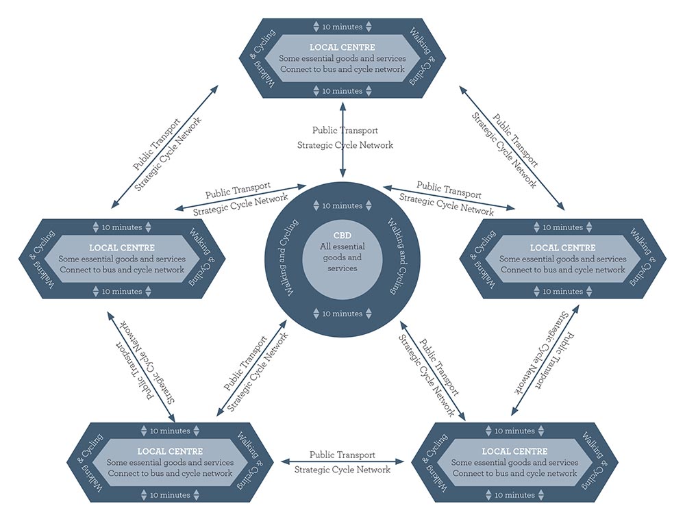 Figure 19. Schematic illustration of compact city with integrated network of hubs and centres, connected by walking, cycling and public transport. Illustration assumes underlying road connections maintained for vehicular use.
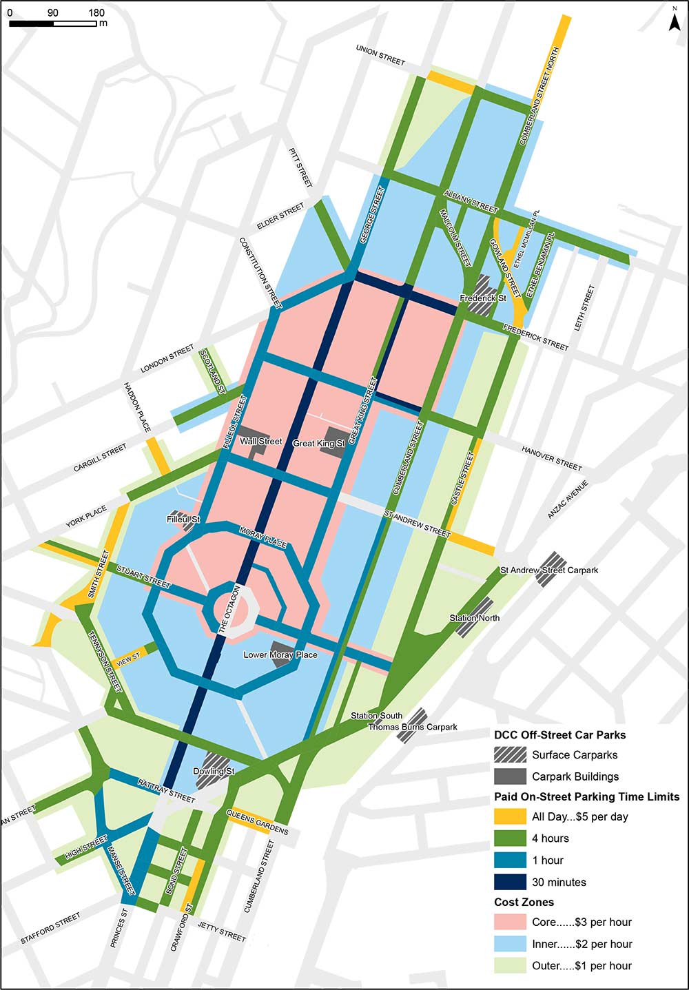 Figure 20. Central City Paid Parking Area