The George/ Bank Connection project is one of the component projects of the Shaping Future Dunedin Transport programme adopted in the 10 year Plan 2021 to 2031.
The DCC received government funding from the now-closed Transport Choices programme included within the Climate Emergency Response Fund (CERF) for the George/Bank St project. This funding was designated to improve the infrastructure along the route but has now been ended by the Ministry of Transport. This means the George/Bank Connection project is not moving ahead. Thank you to those who submitted feedback during consultation.
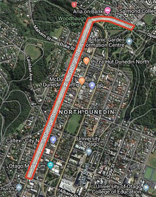
The George/Bank St Connection project aimed to improve safety for users of all ages and abilities along this route, which extends from Albany St to North Rd. It’s a busy road which includes bus stops, shops and schools, as well as being a thoroughfare to the north of the city, and a key residential area for tertiary students. In 2023, we proposed infrastructure improvements to ensure it is safer and easier for everyone to use regardless of their mode of transport, whether that’s walking, driving, cycling, using the bus, and for people who use mobility aids.
-
George/Bank St route map

In 2019, we engaged with the Dunedin public to learn how people use this route (8 other routes were also included) on what problems they encounter, and how they would like to see it changed in the future.
A total of 105 submissions were made through online interactive mapping and an online feedback form about George / Bank St route.
The key themes for the George/Bank St route were that people wanted more crossing points, cycleways, slower speeds, and safer intersections, while minimising parking removal, to help people safely walk to and from the tertiary precinct.
Our Streets 2019 consultation summary
In 2022, Council approved a 30 km/h speed limit reduction outside all Dunedin schools, which includes a new variable speed zone outside George St Normal School. These designs have been developed to work in complement with the lower speed in the George St Normal School Zone. In 2023 DCC consulted on a full Speed Management Plan, which proposed a 30km/h limit for the rest of the corridor.
2023 George/Bank St consultation
The DCC received government funding from the now-closed Transport Choices programme included within the Climate Emergency Response Fund (CERF) for the George/Bank St project. This funding was designated to improve the infrastructure along the route.
The DCC held consultation on design proposals for the route in September 2023. Two options were proposed, both including some changes to parking as a result of intersection infrastructure and in-lane bus stops. We also proposed two options to make the current trial roundabout at Park St/Regent Rd/George St/St David St permanent, and two options for St David Street. Consultation closed 25 September 2023.
- Option 1: includes improvements to intersections, in-lane bus stops and crossing points.
- Option 2: includes improvements to intersections, in-lane bus stops, crossing points and a painted cycle lane.
Option 1 concepts
-
Option 1 concepts
Option 1 includes raised intersections that will reduce vehicle speeds, enable safer and shorter crossing points for pedestrians, and include in-lane bus stops which will make it easier and quicker for people using buses while reducing the impact on parking.
Option 1 changes:
- New bus stop outside 521 George St going north, and new bus stop outside Archives New Zealand going south.
- Bus stops removed outside 607 George St going north (replaced at 521 George St) and 590 George St going south (replaced outside Archives NZ). Raised platform at intersection of George St and Union St West
- Regent Rd/Park St/St David St intersection: Bus stop removed outside 664 George St, moved slightly north to outside Buddha Stix restaurant. Bus stop moved from outside 715 George St to outside 677 George St. Raised pedestrian crossings at each road. Angled parks on Regent Rd become parallel parks, and two unrestricted parks added.
- Raised platform at intersection of Dundas St and George St. the bus stop between 795 - 803 George St is moving to outside 835 George St going north. The bus stop going south is moved to outside 20 Dundas St..
- New speed hump on Howe St at the school gateway, left turn lane removed on George St for a shared straight through and turning lane into Warrender st, southbound bus stop removed from outside 896 George St and moved to outside the George St Normal School signalised crossing at 948 George St, Northbound bus stop outside George St Normal School moved to the north of the signalised crossing.
- Raised platform at intersection of Dundas St and George St, bus stop removed outside 974 George St going south and bus stop removed outside 1007 George St going north. The shared straight ahead and right turn lane at George St/Duke St intersection changed to a right turn lane
- The bus stop outside 1074 George St going south is changing from kerbside to inlane, in the same location. The bus stop removed outside Woodhaugh Gardens entrance going north and moved slightly south to outside 1061 George St.
- Raised dividers on entrance to Pine Hill Road, raised build-outs at intersections.
- Raised crossing point on Bank St, bus stop removed outside Gardens Physio.
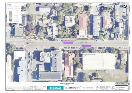
Concept maps
Option 1 design concepts - click on the images to view full screen


Option 2 concepts
-
Option 2 concepts
Option 2 includes similar intersection and bus stop improvements proposed in Option 1, with the addition of painted cycle lanes. There are some sections of this route that will result in more parking changes than Option 1.
Options 2 changes:
- Cycleway along the length of George St, both ways. Southbound bus stop outside #516 removed
- Cycleway continues, kerb build-outs at the intersection corner. Bus stop removed outside Allan Court Hotel going south, and bus stop removed outside 607 George St.
- Cycleway moves onto road to enter roundabout, continues as cycleway as exiting roundabout. Bus stop outside 664 George St moved slightly north to 678 George St. New bus stop outside 677 George St going north. St David St becomes one way.
- Cycleway continues, raised crossing at intersection of George St and Dundas St with kerb build-outs.
- Bus stop removed outside 896 George St, moved slightly south to outside 818 George St. Bus stop added outside 847 George St. Cycleway moves onto road to enter intersection.
- Kerb build-outs at intersection, raised pedestrian crossing on Howe St. Bus stop removed outside George St Normal School and moved slightly more north (still outside the school). Disabled parking zone and pick up/drop off zone relocated slightly further north down the street (still outside the school). New bus stop outside 950 George St (replaces bus stop at 974 George St). Kassel kerbs for both bus stops allow cyclists to continue on path behind bus stop.
- Bus stop removed from 974 George St (relocated slightly south to 950 George St), cycleway moves onto road to enter intersection, where there is a raised crossing. One bus stop removed at 1011 George St going north (moved to 1061 George St).
- New bus stop at 1061 George St going north (replacing bus stop at 1011 George St), raised pedestrian crossing outside 1067 George St. New bus stop outside 1074 George St. Bus stop removed outside Woodhaugh Gardens entrance. Kassel kerbs for both bus stops allow cyclists to continue on path behind bus stop and through to Bank St.
- Cycleway continues through to Bank St, no stopping lines from Willowbank to Bank St to allow cycleway. Kerb build-out outside 38 Bank St.
- Bus stop removed outside Gardens Health Centre, raised pedestrian crossing installed there. Cycleway moves onto road to enter intersection.


Options for roundabout
-
Options for roundabout
There are two options proposed for the roundabout at the George St/Park St/Regent Rd/St David St intersection.
Roundabout Option 1: This option maintains the turning movements for the majority of vehicles.
Roundabout Option 2: This option is a smaller roundabout that caters for a standard sized car, with a mountable centre dome. This means larger vehicles (buses and delivery trucks) will need to traverse the centre dome, and there will be left turn bans (for all vehicles) from George St into Park St, and from Park St into Regent Road.
Roundabout maps
Roundabout design concepts - click on images to view full screen


Additional option for St David Street
-
Additional option for St David Street
To ensure the roundabout improves safety, it is recommended that the number of approaches be reduced. Restricting the exit out of St David Street gives us the opportunity to simplify the roundabout and increase the amount of parking for residents. Therefore, we propose to close the St David Street approach to the roundabout. As a result, there are two proposed options for St David Street between George Street and Great King Street North.
St David St Option 1: This option proposes to turn this block into a one-way street from George Street to Great King St North. This option includes changing the parking layout so more parking spaces can be added, and adding a left turn ban from Great King St into St David St.
St David St Option 2: This option proposes to turn this block into a no exit street, with an entry only from the George St roundabout. This option maintains the existing intersection layout at Great King Street. There are approximately 3 additional carparking spaces in this option.
St David Street maps
St David Street design concepts
St David Street design concepts - click on images to view full screen


Have your say
We asked you to share your views on the George/Bank street design proposal.
Consultation submissions closed at 5pm Monday 25 September 2023.
You can read the submissions received on the consultation:
FAQs
-
Where did this project come from?
This project was originally part of a programme of work called Dunedin Urban Cycleways which started in 2013. This route was part of the Safer Streets/Arterial improvements which was included in the 2018 programme endorsed by Council.
A business case was completed in 2020 and endorsed by Waka Kotahi. In this business case, buffered cycle lanes, bus stop and intersection improvements were proposed along seven routes, George/Bank St was one of these routes.
The implementation of this route was included in the Shaping Future Dunedin Transport programme, as it will support mode shift and improve road safety for people accessing and travelling within the central city. The Shaping Future Dunedin Transport programme was approved by council through the 2021 10 Year Plan.
-
Why in-lane bus stops?
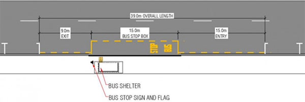
In-lane bus stops require less space than kerb side bus stops which require 39m of space for a bus to enter and exit the bus stop safely.
Kerbside bus stops are the most common bus stop layout for urban and suburban streets in New Zealand. Lead-in and lead-out space is required for the bus to pull out of and back into the kerbside traffic lane.
When on-street parking is too close to a kerbside bus stop, the bus may have trouble entering and exiting the stop and aligning close and parallel to the kerb.

-
How am I meant to negotiate the bus stops as a cyclist?
In option two cyclists will be directed behind the bus stop as per the Waka Kotahi NZ public transport design guidance
-
What is a Kassel Kerb?
Kassel kerbs are built with a higher kerb height to make it easier for people to get on/off a bus as it reduces the step height between the kerb and the bus.
A Kassel kerb is also aligned in a way that makes it easier for bus drivers to line up the bus with the kerb to reduce the horizontal distance to the bus door, without damaging the wheels. The kerbs in the bus hub are Kassel kerbs.
-
How is this project funded?
This project will be 90% funded by Waka Kotahi NZ Transport Agency through the Transport Choices programme, the other 10% is funded by the DCC from the Shaping Future Dunedin Transport programme budget.
